
Where Flight Simulation Enthusiasts Gather from Around the World!
AVSIM Library - Search Results

| Category: Flight Simulator X - Scenery | |
| Harrison Lake Seaplane Base - CAE7 |

|
File Description:
The Village of Harrison Hot Springs is a small community located at the southern end of Harrison Lake in the Fraser Valley of British Columbia, Canada. Air traffic arrives and departs via float planes on the north shore of the town site. This scenery includes the entire resort, new condominiums, and the marinas. There is some really great flying here, and a map is included with the package. VANCOUVER+ is required for this addon scenery to work.
| Filename: | Harrison_Lake_Seaplane_Base__CAE7.zip |
| License: | Freeware, limited distribution |
| Added: | 15th April 2009, 06:07:35 |
| Downloads: | 1,324 |
| Author: | Will Jones |
| Size: | 338.41 KB |
| Category: Navigation and ATC - Navigation | |
| Omaha Sectional Chart Chunks for Aerosoft's FSMap |
|
File Description:
Sectional chart chunks made from the August 2009 Sectional charts at the original scale, formatted in the WGS84 lat/long geographic coordinate system for the FSMap, moving map application for flight simulation use. The chart chunks are the full sectional divided by 2 tiles (east/west) and converted to baseline 8bit tiffs with packbits compression applied. The images are about 6,000x6,000 pixels at about 25mb each, also included is the FSMap fsm Calibration file for importing.
| Filename: | Omaha_Sectional_Chart_Chunks_for_Aerosofts_FSMap.zip |
| License: | Freeware |
| Added: | 22nd March 2010, 20:40:14 |
| Downloads: | 321 |
| Author: | David Myers |
| Size: | 29.55 MB |
| Category: Flight Simulator 2004 - AI Flight Plans | |
| Diego Garcia |
|
File Description:
An updated AI package for Diego Garcia featuring aircraft from MAIW packages so you will need to download and install the following packages from AVSIM or use the interactive map / aircraft selector on the MAIW website to get there.
This file is best used with Matt Magner's Diego Garcia package (which I strongly recommend you get) which can be downloaded from AVSIM or Simviation for the scenery - this gives B2 hangars and a working AFCAD with plenty of parking.
| Filename: | Diego_Garcia.zip |
| License: | Freeware, limited distribution |
| Added: | 1st September 2008, 02:44:20 |
| Downloads: | 969 |
| Author: | Dave Morgan |
| Size: | 252.04 KB |
| Category: Flight Simulator X - Scenery | |
| Cosenza, Calabria, Italy, Photo Real |
|
File Description:
The scenery covers the area of Cosenza and Sila (Calabria, South Italy). The Photo Real Scenery is wide for around 3500 squared Kms. The airport of Lamezia Terme (ICAO code LICA) are found near to the scenery (see map). Otherwise the airport of Crotone (ICAO code LIBC) can be used.
Note for FS2004 user:
This scenery is compatible to 100% with the FS2004 but for the best results, use it in association with Pietro Mauri Italymesh2004.
| Filename: | Cosenza_Calabria_Italy_Photo_Real.zip |
| License: | Freeware |
| Added: | 19th December 2006, 03:16:03 |
| Downloads: | 11,613 |
| Author: | Fulvio Mazzokan |
| Size: | 97.02 MB |
| Category: Flight Simulator 2004 - Scenery | |
| Italy, Toscana 7, Massa Carrara, Photo Real |
|
Images related to this file:
File Description:
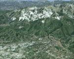
Toscana, Italy, Photoreal Scenery Part 7 (Massa Carrara).
The photoreal scenery covers a great area of Toscana (Tuscany) around the cities of Massa and Carrara. The airport of Firenze Peretola (LIRQ) and Lucca Tassignano (LIQL) and Luni (LIQW) are found near the scenery (see map). For the best results, use it in association with other parts of Toscana photoreal: Toscana 1 Grosseto, Toscana 2 Piombino, Toscana 3 Siena, Toscana 4 Poggibonsi, Toscana 5 Livorno_Lucca_Pisa_Pistoia, Toscana 6 Firenze, italy_islands_vfr_part2_nw.zip
| Filename: | Italy_Toscana_7_Massa_Carrara_Photo_Real.zip |
| License: | Freeware |
| Added: | 27th May 2010, 20:40:19 |
| Downloads: | 5,809 |
| Author: | Fulvio Mazzokan |
| Size: | 91.66 MB |
| Category: Orbiter - Miscellaneous Files | |
| Sol-Italy ver 1.0 |
|
File Description:
This add-on contains 22 italian towns produced using the City Builder tool, and one satellite image of the venetian laguna providing a map of about 30x30 kms around Venice.
Towns are located in the accurate position, considering the level-9 orbiter textures, in order to have a good layout for towns close to the sea. Some towns do not have a base where to land, this means they're are there just for flying over them.
| Filename: | SolItaly_ver_10.zip |
| License: | Freeware |
| Added: | 6th February 2004, 19:21:21 |
| Downloads: | 678 |
| Author: | Stefano Adriani |
| Size: | 1.03 MB |
| Category: Flight Simulator X - Miscellaneous Files | |
| Plan-G data files for New Zealand South Island (NZSI) |
|
File Description:
Plan-G data files for FSX payware Orbx/New Zealand South Island (NZSI).
These PlanG datas display spots of all objects which are provided with the above mentioned software (Points of interest like unlisted airfields, dams, windfarms, lighthouses, huts, etc.) and which are not inserted automatically into PlanG during database re-built. So pick the datas you like to see on your PlanG map and import them into PlanG. For further instructions see the included "readme".
| Filename: | PlanG_data_files_for_New_Zealand_South_Island_NZSI.zip |
| License: | Freeware |
| Added: | 25th March 2012, 21:23:53 |
| Downloads: | 306 |
| Author: | Harald Klose, Dieter Linde |
| Size: | 19.68 KB |
| Category: Flight Simulator 2004 - Utilities | |
| FlightSim Commander 7.7 |
|
File Description:
FlightSim Commander v. 7.7. Flight planner, navigation tool, and moving map for FS2004. Full installation version. You must have a registered fsuipc.dll. Displays both ground and airborne AI traffic, Weather reports for surface and ambient weather, Parking aids to quickly find your assigned parking position, Printable approach charts, airport layouts, and departure routes. Checks and displays control zone violations, realtime track and relative altitude display. New: extended support for VATSIM and IVAO online pilots. Revised topographic layout.
| Filename: | FlightSim_Commander_77.zip |
| License: | Shareware, limited functionality |
| Added: | 29th May 2006, 12:35:19 |
| Downloads: | 3,056 |
| Author: | Sascha W. Felix |
| Size: | 22.28 MB |
| Category: Flight Simulator X - Scenery | |
| Valle D'Aosta part 1 (Est), Alps, Italy, Photo Real |
|
Images related to this file:
File Description:
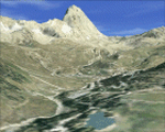
Re-upload. The scenery covers the oriental part of the Valle D'Aosta, North Italy, Alps. The Photo Real Scenery is wide for around 2200 squared Kms. The airport of Aosta (ICAO code LIMW) is found near to the scenery (see map). The complete scenery of the valley was divided in 2 parts to fit the 100Mb file space limit: part 1 (this file) and part 2 (West side see AVSIM library - valle_aosta_west_vfr.zip). For FSX and FS9.
| Filename: | Valle_DAosta_part_1_Est_Alps_Italy_Photo_Real.zip |
| License: | Freeware |
| Added: | 10th June 2010, 23:10:30 |
| Downloads: | 16,643 |
| Author: | Fulvio Mazzokan |
| Size: | 62.3 MB |
| Category: Flight Simulator 2004 - Scenery | |
| Italy, Toscana 5, Livorno Lucca Pisa Pistoia, Photo Real |
|
Images related to this file:
File Description:
Toscana, Italy, Photoreal Scenery Part 5 (Livorno_Lucca_Pisa_Pistoia).
The photoreal scenery covers a great area of Toscana (Tuscany) around the cities of Livorno, Lucca, Pisa and Pistoia. The airports of Pisa San Giusto (LIRP) and Lucca Tassignano (LIQL) are found inside the scenery (see map). For the best results, use it in association with other parts of Toscana photoreal: Toscana 1 Grosseto, Toscana 2 Piombino, Toscana 3 Siena, Toscana 4 Poggibonsi, Toscana 6 Firenze, Toscana 7 Massa_Carrara,
italy_islands_vfr_part2_nw.zip
| Filename: | Italy_Toscana_5_Livorno_Lucca_Pisa_Pistoia_Photo_R.zip |
| License: | Freeware |
| Added: | 6th June 2010, 15:24:12 |
| Downloads: | 6,743 |
| Author: | Fulvio Mazzokan |
| Size: | 83.57 MB |
© 2001-2026 AVSIM Online
All Rights Reserved
Privacy Policy |