
Where Flight Simulation Enthusiasts Gather from Around the World!
AVSIM Library - Search Results

| Category: Flight Simulator X - Scenery | |
| Valle D'Aosta part 1 (Est), Alps, Italy, Photo Real |

|
Images related to this file:
File Description:
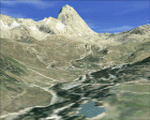
Re-upload. The scenery covers the oriental part of the Valle D'Aosta, North Italy, Alps. The Photo Real Scenery is wide for around 2200 squared Kms. The airport of Aosta (ICAO code LIMW) is found near to the scenery (see map). The complete scenery of the valley was divided in 2 parts to fit the 100Mb file space limit: part 1 (this file) and part 2 (West side see AVSIM library - valle_aosta_west_vfr.zip). For FSX and FS9.
| Filename: | Valle_DAosta_part_1_Est_Alps_Italy_Photo_Real.zip |
| License: | Freeware |
| Added: | 10th June 2010, 23:10:30 |
| Downloads: | 16,647 |
| Author: | Fulvio Mazzokan |
| Size: | 62.3 MB |
| Category: Flight Simulator X - Miscellaneous Files | |
| Plan-G data files for New Zealand South Island (NZSI) |
|
File Description:
Plan-G data files for FSX payware Orbx/New Zealand South Island (NZSI).
These PlanG datas display spots of all objects which are provided with the above mentioned software (Points of interest like unlisted airfields, dams, windfarms, lighthouses, huts, etc.) and which are not inserted automatically into PlanG during database re-built. So pick the datas you like to see on your PlanG map and import them into PlanG. For further instructions see the included "readme".
| Filename: | PlanG_data_files_for_New_Zealand_South_Island_NZSI.zip |
| License: | Freeware |
| Added: | 25th March 2012, 21:23:53 |
| Downloads: | 306 |
| Author: | Harald Klose, Dieter Linde |
| Size: | 19.68 KB |
| Category: Navigation and ATC - Navigation | |
| Omaha Sectional Chart Chunks for Aerosoft's FSMap |
|
File Description:
Sectional chart chunks made from the August 2009 Sectional charts at the original scale, formatted in the WGS84 lat/long geographic coordinate system for the FSMap, moving map application for flight simulation use. The chart chunks are the full sectional divided by 2 tiles (east/west) and converted to baseline 8bit tiffs with packbits compression applied. The images are about 6,000x6,000 pixels at about 25mb each, also included is the FSMap fsm Calibration file for importing.
| Filename: | Omaha_Sectional_Chart_Chunks_for_Aerosofts_FSMap.zip |
| License: | Freeware |
| Added: | 22nd March 2010, 20:40:14 |
| Downloads: | 323 |
| Author: | David Myers |
| Size: | 29.55 MB |
| Category: Civil Flight Simulators - Looking Glass Flight Unlimited 3 | |
| Terrain Meshes Edited With Gmax |
|
File Description:
The area of Pt.Reyes in the San Francisco region are in the upper
right corner of the megatile abag. In the maximum level of details in FU3 we can extract one quart of a megatile to .md3 format to import in
Gmax. The level 3 terrain map can be used as texture over the plane,
so for an area of 129x129 height points meshes can be edited. This is an example converted and ready for a Gmax try.
| Filename: | Terrain_Meshes_Edited_With_Gmax.zip |
| License: | Freeware, limited distribution |
| Added: | 28th December 2002, 22:53:16 |
| Downloads: | 95 |
| Author: | André Meystre |
| Size: | 354.11 KB |
| Category: Flight Simulator 2004 - Scenery | |
| Mt Rainier Fishing Strip |
|
File Description:
Mt Rainier Fishing Strip, a nice little fictional 600 foot grass strip leading upto a Lake at the foot of Mt Rainier, WA State, USA.
Has Cabins for weekend stopovers with night textures for those fishing and hunting trips.
Uses custom and default textures. Recommend using Gerrish Trees with this scenery and autogen set at Max for good forest coverage. Includes a Map Image for Destination Ref from Ranger Creek to aid location of the strip.
| Filename: | Mt_Rainier_Fishing_Strip.zip |
| License: | Freeware |
| Added: | 27th October 2003, 17:33:52 |
| Downloads: | 990 |
| Author: | Jeffrey Stanyer |
| Size: | 405.88 KB |
| Category: Orbiter - Miscellaneous Files | |
| Sol-Italy ver 1.0 |
|
File Description:
This add-on contains 22 italian towns produced using the City Builder tool, and one satellite image of the venetian laguna providing a map of about 30x30 kms around Venice.
Towns are located in the accurate position, considering the level-9 orbiter textures, in order to have a good layout for towns close to the sea. Some towns do not have a base where to land, this means they're are there just for flying over them.
| Filename: | SolItaly_ver_10.zip |
| License: | Freeware |
| Added: | 6th February 2004, 19:21:21 |
| Downloads: | 678 |
| Author: | Stefano Adriani |
| Size: | 1.03 MB |
| Category: Fly! II - Navigation | |
| Plotting Table V |
|
File Description:
The files included in the zip package can be used
to display the area covered by coast and rivers data
(used with ROTW moving map instruments), or to display
a flight user trace between airports and navaids.
Improved display since first version.
Added :
a xml file to customize your own IFR training,
a flight altitude display,
a ARC DME IFR training,
a LOAD button.
Only for PC : OpenGlide rendering.
Tested with XP and NVIDIA GeForce MX 420 64 Mb
| Filename: | Plotting_Table_V.zip |
| License: | Freeware |
| Added: | 31st March 2004, 17:11:23 |
| Downloads: | 107 |
| Author: | Laurent Claudet |
| Size: | 514.36 KB |
| Category: Flight Simulator X - Utilities | |
| FlightSim Commander 8.0 Upgrade |
|
File Description:
FlightSim Commander v. 8.0 is a professional flight planner and moving map for both FS2004 and FS X. This file upgrades from version 7.7 to version 8.0. You must have v. 7.7 properly installed to use this file. Note that your licence file for v. 7.x is no longer valid; for 8.0 you need to register at SimMarket.com. You also need fsuipc.dll v. 4.x if you want to use the program in conjunction with FS X.
| Filename: | FlightSim_Commander_80_Upgrade.zip |
| License: | Shareware, limited functionality |
| Added: | 20th April 2007, 14:07:56 |
| Downloads: | 991 |
| Author: | Sascha W. Felix & Volker Heine |
| Size: | 4.55 MB |
| Category: Flight Simulator 2004 - Utilities | |
| FlightSim Commander 7.7 |
|
File Description:
FlightSim Commander v. 7.7. Flight planner, navigation tool, and moving map for FS2004. Full installation version. You must have a registered fsuipc.dll. Displays both ground and airborne AI traffic, Weather reports for surface and ambient weather, Parking aids to quickly find your assigned parking position, Printable approach charts, airport layouts, and departure routes. Checks and displays control zone violations, realtime track and relative altitude display. New: extended support for VATSIM and IVAO online pilots. Revised topographic layout.
| Filename: | FlightSim_Commander_77.zip |
| License: | Shareware, limited functionality |
| Added: | 29th May 2006, 12:35:19 |
| Downloads: | 3,056 |
| Author: | Sascha W. Felix |
| Size: | 22.28 MB |
| Category: Flight Simulator 2004 - Flight Plans | |
| Brazilian SID/STAR's & Approaches/Gates |
|
File Description:
Brazilian SID/STAR's & Approaches/Gates for PMDG 737 - Version 1.0 (90 airports). The SID/STAR's included in this package are based in the AIP-MAP book issued by DECEA and it is the same used in real life by companies that operate the Boeing 737 in Brazil. This version include complete waypoints names and work with any AIRAC cycle. Use example : Insert the departure and destination airports ICAO names in the PMDG 737 FMC ORIGIN and DEST fields.
| Filename: | Brazilian_SIDSTARs__ApproachesGates.zip |
| License: | Freeware |
| Added: | 28th December 2007, 19:44:21 |
| Downloads: | 4,041 |
| Author: | Adenilson Dias dos Santos |
| Size: | 619.63 KB |


© 2001-2026 AVSIM Online
All Rights Reserved
Privacy Policy |