
Where Flight Simulation Enthusiasts Gather from Around the World!
AVSIM Library - Search Results

| Category: Miscellaneous Files - Miscellaneous Files | |
| 79C - Brennand Airport - Neenah, Wisconsin - USA |

|
Images related to this file:
File Description:
Well this is my 1st attempt at creating/editing an airport so be gentle. I created all the models in sketchup and used ADE to compile the airport. All you should have to do is unzip it and place it with your other add-on scenery and activate it in P3D. This is for P3D V2 only at the moment. When I get a chance I'll get an FSX version done if anyone wants it.
Brennand Airport (79C) located about 4 miles southwest of Neenah WI. This airport is between KATW and KOSH. Brennand has had new ownership since 2013 and they have made many improvements in that time to 79C. So I went out there and took lots of pictures to create what I have for us now. They have built a new building and hangar which I have added along with all the other building on the airport grounds. The runway has been widened from 20 feet to 30 feet and they added PAPI lights on both runways 18 and 36 all of which I have included. I have changed the grass parking areas to reflect the way they are currently set up. (For fun parking area 8 is in the EAA Chapter 41 hangar (Hangar 11) with the door open so you can taxi out of the hangar. Now just need to figure out how to animate the hangar door).
Compatible with P3D v2 ONLY. FSX version may follow later.
| Filename: | 79C__Brennand_Airport__Neenah_Wisconsin__USA.zip |
| License: | Freeware |
| Added: | 4th November 2014, 00:05:41 |
| Downloads: | 99 |
| Author: | Jon Verrett |
| Size: | 32.63 MB |
| Category: Flight Simulator 2004 - Scenery | |
| Havana 1962 Scenery |
|
File Description:
This scenery includes Havana as it was in 1962 (a mysterious city of much fascination for me) including El Morro Fortress on its rocky outcropping at the entrance to Havana harbor, the largest such fortress in the Caribbean, and its adjacent lighthouse. In downtown Havana you will see the capital building and several old cathedrals. Near the Malicon sea walk by the beach, you will find 3 famous hotels and former casinos, the Flamingo, the Riviera, and the Havana Hilton. The Havana Hilton opened just days before Castro seized power and nationalized it. When he first came to power he occupied the top floor for some time. Havana Airport opened originally as Rancho Los Boyeos Airport, located just southwest from the city in the village of the same name, which was then mostly farms, small ranches, and tiny communities. The original terminal was a very pretty Spanish colonial building, which the dictator Fulgencio Batista had remodeled in a 1950's cubist-tudor style. It was at the time of this remodeling (1957) that the airport's name was changed to Jose Marti International Airport, named after the famous Cuban revolutionary and poet of the 19th century. Jose Marti Airport was in the 1950s and 1960s the primary port of entry airport for Cuba. Up until the January 1st 1959 revolution many US airlines served Havana, but due to mounting tensions, the crisis of the Bay of Pigs attack, and later on the October 1962 missile crisis, traffic and tourism was ended as the US led blockade of Cuba took hold. By the time of this scenery, April 1962, the once former bustling Jose Marti airport had become quite sedate.
| Filename: | Havana_1962_Scenery.zip |
| License: | Freeware, limited distribution |
| Added: | 4th March 2010, 23:36:41 |
| Downloads: | 3,867 |
| Author: | Mike Stevens and Tom Gibson |
| Size: | 9.72 MB |
| Category: Flight Simulator 2004 - Scenery | |
| Chatrapatti Shivaji international Airport, Mumbai/ VABB |
|
Images related to this file:
File Description:
Mumbai is having frequent commissioning and decommissioning of various features especially aprons and stands and twy changing nomenclature. However the inf. and resources used while developing the scenery are as on Tue, 22 Jun 2010 13:14:00 UTC. Middle marker for rwy 27 has been permanently withdrawn so the missed approach point of the GP inop. procedure had been amended as 1D ILS/DME in place of middle marker(mm). Navaid BMB freq 396khz withdrawn from service.
New contents include - Commissioning of TWY L4 De-commissioning of portion of Taxi lane L beyond parking stand A1 Aircraft from parking stand A1 to A3 to push back facing west on the taxi lane L, to taxi out via TWY L4 on to TWY N.* Portion of taxi lane L beyond parking stand A1 shall be decommissioned w.e.f. 0430 UTC on 1st July 2010.1. Renaming portion of TWY P from RWY 14 to its junction with TWY E as E4 & TWY Y
as TWY S7
2. Commissioning of TWYs E7, E8, E9 & E10
3. Commissioning of one additional code C Parking Stand on Apron A named A1
4. Decommissioning of Parking Stands T4 & T5
5. Commissioning of Parking Stand G7and Decommissioning of Parking Stand G10 & G14
6. Renaming of Apron K(as apron J ) alongwith it's Parking Stands & Commissioning of
one additional code E Parking stand(J4).
7. Renaming of Apron M ( as apron K).layout chart included.
Scenery features includes - 3 different models of twy edge lights, holding point 3d lights at major intersection.check out pics. if you want extremely frame rate rate friendly update, look for file in library named as - Default mumbai.
| Filename: | Chatrapatti_Shivaji_international_Airport_Mumbai_V.zip |
| License: | Freeware |
| Added: | 22nd June 2010, 22:19:54 |
| Downloads: | 7,267 |
| Author: | Ashish Singh |
| Size: | 63.93 MB |
| Category: Prepar3D V1-4 - Aircraft Repaints, Textures and Modifications | |
| North American P-51D 52nd FG (WD-M) 'Pendaja / Miss Ruth' |
|
Images related to this file:
File Description:

This folder contains a repaint for the A2A WoP3 P-51D Mustang (with AccuSim), in the colors of P-51D-5-NA 44-13287 WD-M, which was the aircraft assigned to Lt William Parent of the 4th FS/ 52nd FG, based in Italy. On the 1st of September 1944 however, it was being flown by Major Wyatt P. Exum during an escort mission to Hungary. It was Maj. Exum's first operational mission nin the ETO. On the way back from the mission, the squadron strafed an airfield, before spotting a moving train. Lts Strout and Wilson attacked the train, and as a result of Lt Wilson's attack, the engine blew up while he was overflying it, damaging his cooling system and setting the engine on fire. The fire quickly blew out, and Lt Wilson decided to make an belly landing in a recently plowed field. Over the radio, he heard Maj Wyatt Exum transmit "I'll be down to get you, Charlie!" and indeed he landed close to Lt Wilson's aircraft. Lt Wilson managed to turn Maj Exum's aircraft, as his tail wheel had become stuck in a rut in the field, and both men tried to squeeze into the cockpit. Meanwhile, men on horseback were approaching, shooting several holes in the aircraft. While Lt Wilson shot back with his .45, Major Exum gunned the engine, and they managed to take off with Lt Wilson half outside the cockpit with his .45. They flew the 400 miles back to Madna in Italy on their last fuel, and landed with other Mustangs landing from the other side. Major Exum received the Silver Star for this action, as well as from the undying gratitude and admiration from Lt Wilson Repaint by Jan Kees Blom, based on the A2A paintkit.
| Filename: | North_American_P51D_52nd_FG_WDM_Pendaja__Miss_Ruth.zip |
| License: | Freeware |
| Added: | 4th November 2018, 17:24:47 |
| Downloads: | 66 |
| Author: | Jan Kees Blom |
| Size: | 11.83 MB |
| Category: Flight Simulator X - Scenery | |
| 2 Fronson Hangars |
|
Images related to this file:
File Description:
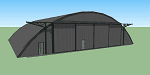
This model was created to be placed in FSX as airport scenery using Airport Design Editor.
I created it for my own use when i was re-creating RNAS HMS Nuthatch which was a Naval Airstation near Anthorn on the Solway Coast in Cumberland (now Cumbria), United Kingdom.
History of RNAS HMS Nuthatch...
Work began on building an airfield at Anthorn for the Fleet Air Arm in late 1943, with Royal Naval Air Station Anthorn, or HMS Nuthatch opening on 7 September 1944, with three tarmac runways.
It was the base of No. 1 Aircraft Receipt and Despatch Unit (No. 1 ARDU), which had the job of receiving aircraft fresh from manufacturers, modifying them to Service standards and despatching them to operational squadrons, with the unit specialising in the Vought F4U Corsair.
No. 1 ARDU continued to operate from Anthorn following the end of the Second World War, while a number of Fleet Air Arm Squadrons were also based at the airfield in the immediate post war years.
The airbase shut down in March 1958.
The Airfield is now the site of a VLF/LF transmitter used for transmitting orders to Submarines, it is also home to three atomic clocks for transmitting Britains time signal transmissions.
None of the Hangars (11 Pentad and 22 Fromson) survive at the site but their concrete standings are still visable.
Depicted here are representations of the Fromson type hangers created from dimensions in a 1947 survey.
I created the model using Google Sketchup and converted it for use in FSX using Model ConverterX.
This is my 1st attempt at scenery creation and is therefore pretty basic.
There are no known issues and it works fine in FSX.
| Filename: | 2_Fronson_Hangars.zip |
| License: | Freeware |
| Added: | 8th June 2014, 07:13:54 |
| Downloads: | 251 |
| Author: | Mark John Byers |
| Size: | 1.4 MB |
| Category: Flight Simulator 2004 - Scenery | |
| LIMN Cameri, Italy (UPDATED v2) |
|
Images related to this file:
File Description:

This scenery is a homage to the great military airport of Cameri NO, Italy; it has been revised with complete new ground that solves the previous flickering problems; it is builded-up with ownmade GMax objects and other existing ones; some buildings by GMax, remainder by others and by Generic Building system.
Information: Built during 1910 close to Novara, it became a prestigious Flight School where a lot of pilots of WWI where trained. Later, Gabardini/CANSA entered by promoting and developing aviation activities, mainly establishing a military flight school. On 27th July 1914, first of story's time, a flight from Cameri crossed the Alps (Camery - Viege, over Monte Rosa) with a Gabardini 80HP aircraft and pilot Achille Landini together with Giuseppe Lampugnani passenger. On 1930 the school closed, but the field still remained as aviation workshop. During the WWII the airport was quite destroyed by the german army, during their retreat. After the war, the rebuild operations carried on to Cameri several details, of which the acrobatic patrol of "Lancieri Neri" and, 1967-1999, the great 53th "Stormo Caccia". On 1998 the storm was moved to Gioia del Colle airport and the base was restructured as Comand Airport, where some technical departments still works (the 453th Operative Technical Services Group, the 553th Logistic Operative Services Group and, mainly the 1st Aircrafts Maintenance Dep.nt)
Contents: all around new great terrain for about 4.5 x 3.5 km; static aircraft inside hangar as Tornado, Eurofighter and historic monoliths at admittance and inside airport; ground equipments, cars outside and inside airport, bus, tankers, emergency trucks; military shelters (10) and workshop ones (5); buildings outside/inside airport, control tower, VOR, radar tower and some other navaids; lights at hangars, admittance and all over the boundaries; more then 10 km boundary by walls and fences of the complete areas; thousands trees all over the scenery. This scenery includes the airport scenery content only. You can find separate further sceneries for Babini Army station and Museum
| Filename: | LIMN_Cameri_Italy_UPDATED_v2.zip |
| License: | Freeware |
| Added: | 20th October 2011, 00:20:05 |
| Downloads: | 2,358 |
| Author: | Aldo Della Vedova, Daniele Lanfranchi |
| Size: | 25.08 MB |
| Category: Flight Simulator X - Scenery | |
| RAF Polebrook |
|
File Description:
On June 28, 1942, RAF Polebrook was officially turned over to the USAAF and the airbase became the base of the 97th Bombardment Group, the first USAAF heavy bomber organization to arrive in the UK. It was designated USAAF Station 110.
The 97th BG was assigned to the 1st Combat Wing, at RAF Bassingbourn. It's operational squadrons were divided between Polebrook and RAF Grafton Underwood:
340th Bomb Squadron (RAF Polebrook)
341st Bomb Squadron (RAF Polebrook)
The 97th BG conducted a total of 14 missions from Polebrook, attacking airfields, marshalling yards, industries, naval installations, and other targets in France and the Low Countries.
The group sortied 247 aircraft, dropped 395 tons of bombs on Nazi-controlled territory, and lost 14 aircraft. On October 21, 1942, the 97th Bomb Group was transferred to the Twelfth Air Force in the Mediterranean theater and Polebrook was unoccupied until April 1943.
351st Bombardment Group (Heavy)
On April 15, 1943, the 351st Bomb Group arrived at RAF Polebrook. It was assigned to the 94th Combat Wing, also at Polebrook. The group tail code was a "Triangle J". It's operational squadrons were:
508th Bomb Squadron (YB)
509th Bomb Squadron (RQ)
510th Bomb Squadron (TU)
511th Bomb Squadron (DS)
Boeing B-17G-85-BO Flying Fortress, Serial 43-38465 of the 510th Bomb Squadron. This aircraft survived the war and returned to USA on 8 June 1945
Douglas-Long Beach B-17G-30-DL Flying Fortress Serial 43-38116 of the 509th Bomb Squadron.The 351st's first completed combat mission took place on May 14, 1943, when 18 B-17's targeted a German Luftwaffe airfield at Kortrijk, Belgium. As the war progressed, the 351st operated primarily against strategic objectives in Germany, striking such targets as ball-bearing plants at Schweinfurt, communications at Mayen, marshalling yards at Koblenz, a locomotive and tank factory at Hannover, industries at Berlin, bridges at Cologne, an armaments factory at Mannheim, and oil refineries at Hamburg.This is for FSX and you will need to have Ted Andrews's RAF Hangars Library and his other great RAF Buildings. They can
be found on AVSIM. Search the FSX section for "Ted Andrews" - you'll find loads of his scenery object files for
RAF airfields. Follow his instructions on how to install them.
| Filename: | RAF_Polebrook.zip |
| License: | Freeware |
| Added: | 21st January 2009, 13:27:45 |
| Downloads: | 1,058 |
| Author: | Scott Berge |
| Size: | 15.01 KB |
| Category: Flight Simulator X - Scenery | |
| hythevillage_pier.zip |
|
File Description:
Hythe Village and Pier
Hythe Village [Town] nestles between the edge of Southampton Water and the New Forest, some 500 yards west of the ‘American Base – RAF Hythe’; the surrounding area is known as ‘The Waterside’. Hythe, with its waterfront, boasts incredible views across Southampton Water, while the village [town] centre, with its Georgian High Street, offers a range of shops, services, traffic-free precincts and parking facilities. Nearby is ‘Hythe Marina’, to be found on Southampton Water's southern shore; it’s a unique development of a 206 berth marina, together with waterside homes, shops, restaurants, bars and a boutique hotel.There is also a passenger ferry which sails back-and-forth from Hythe Pier to the City of Southampton every 30 minutes. Before Hythe Pier was built, ferry and other boats arriving at Hythe had to use a gravel hard ramp which ran from the land out to the low tide point in Southampton Water. Walking along the hard gravel was not easy and travellers often got very wet. Various ideas to improve the situation were suggested at the time and construction of Hythe Pier was eventually started in October 1879 and officially opened on the 1st January 1881. Many World War II heroes departed from this pier on D-Day in June 1944.The pier itself stretches some 640 meters into Southampton Water and is one of the ten longest piers in the British Isles. In 1922, a narrow gauge electric railway opened in order to take passengers the full length of the Pier. This railway, with its original engine and rolling stock, is the oldest operating electric pier train in the world and is still operational to this day – playing an important part in the local transportation system between Hythe and Southampton.
Scenery Features
* Bus Shelter
* Ferry Ticket Collectors (On pier landing platform)
* Ferry Ticket Office
* High Street Shops
* Hotspur House
* Hythe Library & Car Park
* Hythe Pier
* Hythe Pier Landing Platform
* Hythe Promenade
* Library Road & Shops
* Lidl Superstore & Car Park
* People (Static & animated)
* Pier Railway & Safety Railings
* Pier Train (Parked at village end of pier)
* Lord Nelson Public House
* Prospect Place Park
* Public Toilets
* Seashells Lounge Bar & Restaurant
* St. John's Church & Cemetery
* Street Lighting
* Streets & Roadways
* ‘The Marsh’ & New Road
* Vegetation (Trees, bushes)
* Vehicles (Buses & cars)
* Waitrose Supermarket & Car Park
* WWII Remembrance Plaque (Prospect Place)
Special Effects
* Animated Birds (seagulls-close to village & pier)
* Chimney Smoke
* Night, Dusk & Dawn Lighting Effects
* Seagull Cry Sounds
| Filename: | hythevillage_pierzip.zip |
| License: | Freeware |
| Added: | 21st November 2025, 12:42:28 |
| Downloads: | 76 |
| Author: | Barrie Semmens |
| Size: | 16.37 MB |
| Category: Prepar3D V1-4 - Utilities | |
| Flightplan Visualizer 1.16 |
|
Images related to this file:
File Description:
Flightplan Visualizer (FV) version 1.16.0. Copyright 2018-2020 by Pelle F. S. Liljendal ([email protected]), all rights reserved.
FV comes with 765 pre-imported Commercial AI flightplans (+380 BizJet flightplans are available as a separate download). However you are able to import additional (AI) flightplans yourself. Once imported these (AI) flightplans can be visualized on a map-view, and the user will be able to search accross all these. Hence you can use the program as inspiration as to which routes to fly. E.g. you can search across all imported flightplans to find all flights in an A321 flying into/out from LDDU, or simply to look for all flights in a Boeing 747-8F.
Simply run the included installer to install the software. The program will be installed into "C:\Program Files (x86)\Flightplan Visualizer" and all datafiles will be installed into: "C:\Users\[UserName]\AppData\Roaming\FlightplanVisualizer". The program comes with a full manual explaining everything, and a 3 page quick manual to get you started. The first 3 times you run the program the quick manual will automatically open. The forum is hosted here: https://forum.aerosoft.com/index.php?/forum/919-flightplan-visualizer/
Version 1.16 Contains the following changes:
- First of all a big THANK YOU to AIG (Alpha India Group) for allowing me to add features to both download their flight-plans (actually a feature suggested by Kai Kamjunke who is one of the developers of AIG AIM and other AIG tools) and access their list of defunct/renamed flightplans. While giving thanks, I also want to thank all (AI) aircraft-model creators, repainters and those who create all the flightplans ... our virtual sky would not be the same without your hard and dedicated work.
- Added new form to download or install AIG flightplans (downloaded directly from the AIG-servers). The form will identify all flightplans that are newer than those already installed or flightplans that are not currently installed. You can simply double-click a flightplan and it will be directly installed without the need to first download the file, and then choose to import this file.
- Both the new flightplan download- and the enable/disable flightplan- form contains a button which download- and show a list of defunct/renamed flightplans (obtained directly from the AIG forum).
- If you create a user-Airline while importing a flight-plan, when you return to the import-form you will be asked if you want to use that newly created flightplan (saves you from having to open the airline-browser and search-for/select that user-airline).
- Added Flightplan-, Airline- and Aircraft-filter to the top of the leg-search form to filter the items shown in the listviews.
- The "Select All" and "Select None" buttons now only (de)select visible items (if a filter is active there might be more items not displayed). However holding SHIFT while pressing these buttons, ALL items will be (de)selected no matter if they are shown or not.
- Replaced the two airport entry fields (in the leg-search form) with filter combo-boxes (MRU) so you can now enter a filter-text to filter which airports to include (the default filter is usign ICAO-codes so the old functionallity is preserved).
- Added filters to search for legs with specific flight-numbers and/or served by aircraft with specific registrations.
- When setting up a filter, sub-elements of the same type can now be separated by "/" so you only have to enter the type-name once (e.g. "country=dnk/nor/swe"). The pipe-char ("|") can be uses in stead if you prefer (e.g. "country=dnk|nor|swe").
- Now both "?" and "%" can be used as a single char wildcard in the filters ("?" is a DOS wildcard, whereas "%" is a SQL-wildcard).
- Added "#" as a wildcard for a single numeric value (0-9) in filters.
- Added "@" as a wildcard for a single alpha value (A-Z) in filters.
- Improved detection of invalid filter-text, which changes the text-color into red, to indicatet that the filter is invalid.
- The ISO3 country-code is now visible in the country combo-boxes in the leg-search form (these codes can be used in the airline- and airport- filters).
- Likewise 3-char Region- and Sub-region -codes have been added to their respective combo-boxes (these codes can also be used in the airline- and airport- filters).
- Saving the leg-search criteria will no longer require the input to be validated. E.g. you can now save the criteria where no aircraft have been selected. If you want to make sure that the criteria is valid for a search, please perform a search before you save the criteria.
- Flightplan-filter added to the "Re-process flightplans" form.
- Aircraft-filter added to the "Choose favorite aircraft-types" form. Also a few extra columns were added to the aicraft list-view.
- The Decode-METAR/TAF form now allows the user to manually enter METAR/TAF messages, and the form can now be opened directly from the main-menu (in case you optain METAR/TAF from other sources and need to decode it).
- Added a new button to the Randomizer form which lets you pick a random route (there is already a button to pick a random flight). The difference is the statistical chance of the chosen route.
- Added 2 columns to the runways listview in the Airport-info form showing head/cross-wind based on selected wind-direction/speed (automatically updated from the obtained METAR report).
- When accepting the result of a leg-search the previous used criteria (if different) are now archived. So you are able to load the 5 last used search criteria.
- The Result-viewer form now have a "Top-most" check-box. When checked that form will be shown on top of all other windows. This allows you to have this form shown on top of other forms (e.g. if you need to enter data from a metar-message into the FMC in the simulator).
- Many of the result-viewer forms now opens non-modal, meaning it can be displayed next to the window form where it was opened and you can switch between the two (you might need to use the new "Top-most" check-box for the best result). When closing the form from where the result-viewer was opened, the result-viewer will be closed as well.
- Likewise the Unit Conversion form also got the "Top-most" check-box in case you want to display this window on top of another program (e.g. if you have paper-work with weight based on kg and you need to enter the weights into a FMC/MCDU that only accepts lbs (or vice versa).
- The "Copy to clipboard" buttons on the METAR/TAF-decode form, and the Leg-Info form have been replaced by a "Show Report" button in stead. This new button will in stead show the text in the Result-viewer form (if you need to, it can be clipped to the clipboard from there).
- Below the (left/right) list-views in the "Enable/disable flightplans" form you now find a label showing two numbers. The 1st number shows the number of items (flightplans) shown in the list-view, and the 2nd number (in the parentheses) shows the number of selected items.
- When importing a flightplan where the aircraft-type can not be detected, the "lines" assigned to the "DUMMY AIRCRAFT" are now all automatically selected. So it is easy to just hit the "Change Aircraft type" button in case there is just a single, or multiple that should have the same type assigned.
- Hoovering the mouse over the gate-markers in the Airport-info form, the tool-tip now contains the GPS-position of the gate. Likewise editing the gate the caption of the edit window contains the GPS-position.
- Added airport size to "FS Comment" column in the "Nearby Airports" form.
- Added line-breaks to the METAR/TAF tool-tips displayed in the Leg-info form (line-breaks also included in the report).
- Fixed: There was a nasty bug in the "Legs" tab-page of the Airport-Info form where the same time-zone was used for both departure- and destination-airport when showing the departure-/destination-times as local times, even if departure- and destination-airports were in different time-zones.
- Fixed: The value of the "Calculated flighttime" check-box in the leg-search form was not set to the loaded value.
- Fixed: If one of your user-airlines had a blank callsign, it would list all airlines with a blank callsign as alternatives. Now it will only try to match non-blank callsigns.
- Fixed: The METAR/TAF decoder was not able to correctly detect a fraction visibility if following variable wind (e.g. "210V290 3/8SM").
- Fixed: Some of the combo-boxes in the leg-search form were enabled for text-entry, where the user should only be able to pick a value.
- Fixed: If "[None]" was selected and you executed a leg-search the "Edit" button remained disabled when you returned to the main form.
- Data: While testing some of the new filters I saw a few erros in the aircraft data (e.g. a few freight aircraft had a non-zero passenger count and other minor issues like that), which were fixed.
- Data: Thanks to Bruce Nicholson for bringing it to my attention that DC-9-15F was not being detected in version 1.15. Now all the DC-9 sub-variants should be detected correctly (e.g. 9-11/12/13/14...51 both pax and freight). The same better sub-variant detection was added to the DC-8's and DC-10's as well.
- Data: Thanks to Aucery for bringing it to my attension that some of the (BizJet) aircraft were not being detected, or not being detected correctly. The King Air 250/300 should now be detected correctly as are Hawker-700/1000, Mitsubishi MU-300, IAI Astra Jet 1125, Cessna T210/T303, and Dornier 328JET/PROP.
- Flightplans: All new/updated flightplans have been added to the installer, and all obsolete have been removed. A total of 765 active flightplans are bundled with the installer.
Pelle
| Filename: | Flightplan_Visualizer_116.zip |
| License: | Freeware, limited distribution |
| Added: | 2nd May 2020, 23:15:38 |
| Downloads: | 318 |
| Author: | Pelle Liljendal |
| Size: | 29.27 MB |
| Category: Microsoft Flight Simulator (2020) - Utilities | |
| Flightplan Visualizer 1.22 |
|
Images related to this file:
File Description:
Flightplan Visualizer (FV) version 1.22. Copyright 2018-2022 by Pelle F. S. Liljendal ([email protected]), all rights reserved.
FV comes with 1599 pre-imported AI flightplans (of which +726 are BizJet flightplans, the rest are commercial, government and military). However you are able to import additional (AI) flightplans yourself. Once imported these (AI) flightplans can be visualized on a map-view, and the user will be able to search accross all these. Hence you can use the program as inspiration as to which routes to fly. E.g. you can search across all imported flightplans to find all flights in an A321 flying into/out from LDDU, or simply to look for all flights in a Boeing 747-8F.
Simply run the included installer to install the software. The program will be installed into "C:\Program Files (x86)\Flightplan Visualizer" and all datafiles will be installed into: "C:\Users\[UserName]\AppData\Roaming\FlightplanVisualizer". The program comes with a full manual explaining everything, and a 3 page quick manual to get you started. The first 3 times you run the program the quick manual will automatically open. The forum is hosted here: https://forum.aerosoft.com/index.php?/forum/919-flightplan-visualizer/
Version 1.22 Contains the following changes:
- I had initially added a feature to download AIG airline-logos, however a later change in AIG's server setup rendered this feature useless. In stead you can now specify the local folder holding AIG's airline logo's (if/when you are using AIG AIM on your computer for AI-traffic). If specified, airline-logo's will be obtained from this folder.
- On the same note, I had to remove the menu-item to download AIG flightplans, as this program no longer have directly access to the AIG servers. For the same reason the menu-item to access the index with flightplans (up to summer 2021) was re-enabled.
- In the past when opening the Airport-Info form it defaulted to show in-/out-going traffic for the selected flightplan or active leg-search only. Now there is a new setting where you can set it up to in stead default to showing all traffic in/out of the airport (the Airport-info form still contains a combobox where you maually can choose what to see).
- "Owned aircraft" was renamed into "Simulator-aircraft", as these are the (flyable) aircraft you have available within your simulator of choise.
- When choosing to use calculated flight-times in a leg-search, you can now specify a percentage-difference (between leg-time and calculated-time). Only when the difference between leg-time and calculated-time exceeds this specified value will the calculated time be used during leg-search (e.g. "only use calc-times if diff. exceeds 50%, otherwise use leg-times").
- Began using (aircraft) short-names many places where the program in the past used IATA/ICAO-code (e.g. when hovering the mouse over a route, or list of aircraft servicing specific airports when editing flightplans). Also added short-name columns to aircraft browser and when choosing favorites (these stil contains columns for IATA/ICAO-codes).
- Pressing the "Usage" button when editing/viewing an aircraft-type or right-clicking an aircraft-type in the browser and choosing "View usage-report..." from the context menu, you will be shown a report that inform you how that aircraft-type is used: which simulator-aircraft are based on that type, which owned aircraft that have been marked as substitute for that type, which airlines are using that type (as carrier/operator), and finally in which (active) flightplans that type is used.
- Items in airline-browser are now by default sorted by (airline) name, and the usage-column shows the size of the airline if its in use. If available a logo for the selected airline is displayed in the upper/right corner.
- Improved performance when searching for ICAO-codes in the airport-browser. Also improved priority of the default selected item, in cases when an airport had a 3 letter ICAO-code, and another was using the same 3 leters for its IATA code.
- When searching for ICAO/IATA-codes in the airline-browser, it will now prioritize non-defunct airlines, if multiple airlines share the same ICAO/IATA-code.
- When enabling/disabling flightplans, you can now select all BizJet flightplans (those prefixed with "Bz_"), all Military (prefixed with "Ml_") or all Goverment (prefixed with "Gv_").
- Individual FP sub-folders can now be setup to leave (not move) defunct- and/or obsolete FP, even if the settings to automatic move these to the disabled folder is set.
- Performing "Search legs" you can now filter on aircrafts you are allowed to fly via type-ratings ("Must be type-rated").
- Performing a substitute of a user-airline, that airline will remain selected (previously the list scrolled to the top, and selected the 1st item).
- Added new check-box to "Search legs" that can exclude round-trips (legs taking-off and landing at same airport).
- Airline/Aircraft-repaint -filter can now filter on size of airline (e.g. "size=major"). Size is determined from usage as carrier/operator in active flightplans. Airlines not in use by active flightplans are listed with a size of "unknown").
- Added GPS-conversion (deg deg,min,sec) to the conversion-form, as requested by a colleague. You can either manually enter lat/lon or look-up an airport to get it. There is both a primary lat/lon and a secondary, and the form will show the (GC)distance between these and the initial/final course.
- Added new "Max airport-distance" for airport-redirections. At the same time added new feature when importing/editing airports to permanent change an airport. If used, it is not saved/handled as a redirection (can't be restored) but rather as a perpament change.
- Reordered- and renamed some of the tab-pages in the Airport-info form.
- Reordered the length/distance-fields in the unit-conversion form.
- The Wind-calculator have been removed from the main-menu, in stead wind-calcuations can now be performed using the unit-conversion form. Also now the speed of the wind is always displayed as a positive value, and in stead the label will either say "Head-wind" or "Tail-wind".
- Added new "Country list" menu-item in the misc-menu. Will list all countries twice (sorted by names, and sorted by ISO3-codes).
- Showing airport-marker tool-tips on the main-map is now prioritized over showing route tool-tips.
- Added "Min take-off fuel ("MTFL") field to user-aircraft weight-fields. As of now its not set for any aircraft in the database, however it can be estimated as 60 minutes of flight at cruise.
- Moved several group-boxes of the settings-form to the 2nd tab-page, and added new fields for defalt simulator/logging-environment based on the File-prefix used when starting the program.
- Also now the header-names that was previous fixed to "Rank" and "Traffic-density" can be changed, so the selectable 6 values can be used for something entirely different, if anyone have the need for this. If/when changed, these new names are shown when editing an airport, or when performing a leg-search (as the leg-search can filter on these fields).
- MakeRunways (MkRwy) by Pete Dowson is challenged handling unicode in the scenery it scans/writes to XML. E.g. the Icelandic airport (BIFL) "Flúðir Airport" is exported by MkRwy as "Flúðir Airport". In this version FV will try to identify when this happens, and then it will fall back using the airport/city-names from the databases bundled with FV. This is not a perfect solution, but at least it improves the result.
- Various minor changes and tweaks to multiple forms (e.g. Unit conversion form can now be closed with ESC, renamed log-archives and so on).
- Fixed: If the main-form had an active flightplan filter when using the search-legs feature the flightplan combo-box still only contained the filtered context. Pressing the Clear button did not resolve the issue.
- Fixed: Since adding support for the AIGFP file-format, there could be flights departing from- and arriving at the same airport (e.g. helicopter flights). In previous versions the calculated flights-time would only consist of taxi-out/in times. In this version the flightplan leg-time will now also be uses for the calculated time, when the same airport is used both for departure and destination.
- Fixed: In some cases re-processing flightplans (resetting and performing redirection) could corrupt the flightplans and remove airport-data from the flightplans. This version will also try to add any missing airport-data to flightplans when re-processing them.
- Fixed: Selecting "only show favorites" in the Search aircraft-type form would filter out all aircraft (including those marked as favories).
- Fixed: In the leg-info form the fields to show times (Out, Off, On, In) were too narrow for multi-week flights, when showing the week-number (e.g. "TH7/14:37").
- Fixed: Issues when estimating cruise/taxi fuel-burn for user-aircraft, where in some cases some fields were not saved, and wrong calcuation if setup to show weight in Kg.
- Fixed: In some cases wrong TimeZone was used when calculating local time for OUT, OFF, ON, IN-times.
- Data: The airport redirection file ("UserAirportRedirect.xml") in the UserData folder have been updated to match the latest MSFS world update. However this new file is only installed by the installer if it does not already exists (in case you made your own changes), hence you need to delete this file manually prior to running the version 1.22 installer.
- Data: Quite a few airports in the airport-database were updated (had wrong names due to issues with unicode-letters). Also some additional airports were added.
- Data: The installer comes bundled with +300 airline-logos (optional install), and a separat package of +1400 airline-logos are avilable for download from AVSIM (in both cases these are encoded into a propriotary format using the ".CAL" extension).
- Data: Added the P2F (Passenger-to-Freighter) versions of the Airbus A320, A321 and A330. Also added the package freighter versions of CRJ100 and CRJ200.
- Data: Improved detection of Boeing 737-700/800 BCF/BDSF when importing flightplans utilizing these (passenger aircraft converted into freighters). Also improved a few other freighter detections.
- Data: Changed a few (aircraft) short-names to either shorten them a bit, or make them "more readable".
- Flightplans: All new/updated flightplans have been added to the installer, and all obsolete/defunct have been marked/removed. A total of 1599 active flightplans are bundled with the installer.
| Filename: | Flightplan_Visualizer_122.zip |
| License: | Freeware, limited distribution |
| Added: | 18th October 2022, 23:31:28 |
| Downloads: | 398 |
| Author: | Pelle Liljendal |
| Size: | 45.57 MB |


© 2001-2026 AVSIM Online
All Rights Reserved
Privacy Policy |