
Where Flight Simulation Enthusiasts Gather from Around the World!
AVSIM Library - Search Results

| Category: Flight Simulator 2004 - Panels | |
| Flight1 ATR72 PANEL Enhancement -FAPE- |

|
File Description:
What FAPE does for you??
1) FAPE adds about 50 new clickspots to make easier the opening/closing of every panel window, following GUI ergonomical rules. You won't move your mouse anymore to open popup panels.
2) FAPE adds a clickspot to display the RealityXP500 Weather Radar (if you own it, of course).
3) FAPE integrates Rob Barendregt's nice Pushback gauge within the center panel.
4) FAPE displays the FMS in a smaller size and in the right bottom corner of the screen.
5) FAPE allows using the Panel Controller Window (panel icons) from the VFR window configuration, so you will be able to open every other panel from the VFR panel.
WARNING: THIS FILE IS ONLY FOR FLIGHT1 ATR72 OWNERS (GO AND BUY IT, IT'S A FANTASTIC AIRCRAFT!!) USING THE BROWN CONDENSED PANEL. UPON SIMMERS DEMAND I WILL DO THE SAME FOR THE BLUE CONFIG.
Enjoy!
| Filename: | Flight1_ATR72_PANEL_Enhancement_FAPE.zip |
| License: | Freeware |
| Added: | 10th November 2004, 14:02:26 |
| Downloads: | 2,500 |
| Author: | David Roch |
| Size: | 911.88 KB |
| Category: Flight Simulator 2004 - Utilities | |
| FS Launcher |
|
File Description:
Yes I know there are more programs like this, but this one includes some features I have missed:
You can optionally select the start flight from your saved flights and you can also set another time or weather for it.
And there is something else, which may sound familiar to you:
You had a nice flight yesterday with VATSIM or IVAO with your FS configured to keep running during temporary application changes.
Today you are flying on your own and are on short final for landing when you get interrupted by another application (like an incoming email).
When you came back to FS you may find your aircraft with it's nose in the ground because it did not wait for you.
Besides the usual preparations, FSLaunch lets you set the pause configuration before starting FS.
The program is in English and German and provides a short help file.
| Filename: | FS_Launcher.zip |
| License: | Freeware, limited distribution |
| Added: | 11th May 2005, 15:21:48 |
| Downloads: | 1,276 |
| Author: | Wolfgang Meininghaus |
| Size: | 590.67 KB |
| Category: Flight Simulator 2004 - Scenery | |
| CYQV Yorkton Municipal Airport Saskatchewan Version 2 |
|
Images related to this file:
File Description:

Yorkton Municipal Airport is situated approximately three kilometers north of the City of Yorkton, Saskatchewan, Canada. The airfield was built in 1940 for the Royal Canadian Air Force, as a British Commonwealth Air Training Plan station. Today, only a few of the wartime buildings remain and only two of the orginal four runways remain in operation. The airport continues, however, as the prinicipal hub of general aviation services for the east-central region of Saskatchewan.
CYQV was constructed using GMAX and represents the airport as it was in the Summer of 2008. It includes custom models of all the buildings at the airport, runway signs, refueling facilites,garages, weather station, fencing and trees, and a rotating beacon. CYQV includes custom ground textures to replicate the decommissioned runways and taxiways.
Version 2 replaces the original lost in the AVSIM hack and includes a number of improvements (see readme).
| Filename: | CYQV_Yorkton_Municipal_Airport_Saskatchewan_Versio.zip |
| License: | Freeware |
| Added: | 7th May 2010, 12:52:18 |
| Downloads: | 1,997 |
| Author: | Gregory Putz |
| Size: | 6.72 MB |
| Category: Flight Simulator 2004 - Scenery | |
| Oberpfaffenhofen v2.2 |
|
Images related to this file:
File Description:
This factory airport is located in the west of Munich (lovely Bavaria, South-Germany).The simulated version of the airport I dedicated to Claude Dornier, one of the
very famous aviation pioneers in the last century. Civil and military aircraft are manufactured and/or serviced on this airport. Over the years the ownership has changed in 1996 from Dornier to Fairchild/Dornier and in December 2002 to RUAG (Swiss Company). The airport also is hosting the "DLR" (German Aerospace Center) at the south western part of the field.
Version 2.2 replaces version 1 and 2.1 completely. Several airport buildings have
been modified and all the scenery textures have been converted to the DXT1/DXT3 format.
All EZ-Scenery BGL's and Textures are on board, therefore no further library downloads
are required. Gentlemen, it's time to get the weather briefing.
Re-upload.
| Filename: | Oberpfaffenhofen_v22.zip |
| License: | Freeware |
| Added: | 8th April 2011, 11:44:36 |
| Downloads: | 2,556 |
| Author: | Klaus Jone |
| Size: | 32.76 MB |
| Category: Flight Simulator X - Aircraft Repaints, Textures and Modifications | |
| Douglas R4D-8 US Navy #17171 |
|
Images related to this file:
File Description:
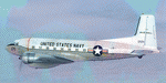
This folder contains a repaint for the Douglas C-117D by Manfred Jahn and colleagues in the colors of 17171 of the US Navy, which made an emergency landing in Iceland in 1973. On the 24th of november of that year, the Douglas R4D-8 17171 on route to Höfn à Hornafirði was forced to make an emergency landing at Sólheimasandur due to bad weather conditions at Höfn and low fuel. The landing was successful and the plane suffered no major damages. At the time the US navy was discontinuing it’s use of the Douglas C-47 and instead of repairing it, the plane was stripped of all valuables and abandoned in the black volcanic sand. Since then it’s been a favourite of photographers and adventure seeking tourists. Repaint by Jan Kees Blom, based on the paintkit by Gman5250.
| Filename: | Douglas_R4D8_US_Navy_17171.zip |
| License: | Freeware |
| Added: | 7th August 2018, 12:36:18 |
| Downloads: | 192 |
| Author: | Jan Kees Blom |
| Size: | 11.55 MB |
| Category: Flight Simulator X - Utilities | |
| Boeing 737 Dispatch sheet v 4.9.7 |
|
Images related to this file:
File Description:
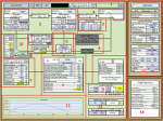
The 737 Dispatch sheet is a comprehensive dispatcher, fuel planner and performance calculator in Excel 2007 and above. It is designed to be used with the PMDG NGX and its ranges of engine and weight variants and other options such as Short Field Package and winglets. Calculations are based on many available optional user inputs such as selected Cost Index, weather information, altitudes en route, altitude steps, passenger load, luggage, and many other factors that impacts fuel usage and aircraft performance. The calculations include takeoff and landing weights as well as estimated flight time, cruise speeds and more. The build in airport and runway database helps you find all the information you would need to plan your flight including takeoff performance settings, engine derates, assumed temperatures, landing configuration, landing and takeoff speeds, and more. This updated version corrects a few issues with time zone calculations.
| Filename: | Boeing_737_Dispatch_sheet_v_497.zip |
| License: | Freeware |
| Added: | 27th January 2015, 23:04:14 |
| Downloads: | 2,636 |
| Author: | Lasse Kronborg |
| Size: | 8.65 MB |
| Category: Miscellaneous Files - General Utilities | |
| British Aerospace 146 / Avro RJ Runway Performance Calculator |
|
File Description:
This file is an Open Office Calc spreadsheet which calculates the runway performance required by the BAe146 / Avro RJ family of aircraft. The user is required to enter the passenger numbers, freight and fuel figures in kg, and the departure and destination airfield data and weather. The spreadsheet will calculate the required runway TODA and LDA distances in meters and provide an FSX/P3D fuel and payload table to be copied into the simulator. Note. the figures supplied are based on published British Aerospace data, but not taken from actual performance documents. If entering pressure in inches then leave MB as zero to obtain the correct calculation. The landing weight calculations are based on the take off weight and estimated fuel burn. To obtain a more accurate calculation then add the TOD fuel weight in the box provided. Weights in kgs and runway data in meters.
| Filename: | British_Aerospace_146__Avro_RJ_Runway_Performance_.zip |
| License: | Freeware |
| Added: | 23rd October 2016, 18:53:32 |
| Downloads: | 707 |
| Author: | Paul Gale |
| Size: | 36.63 KB |
| Category: Miscellaneous Files - Demos from Commercial Vendors | |
| Latin VFR Cuzco Photo and Airport Scenery |
|
File Description:
Cuzco or how is also formally known today as “Cusco” is one of the most important cities of Peru and is the historic capital of the Inca empire, it is also the historical capital of Peru designated by its constitution. The city is located in the Andes mountains and its elevation is above 3310 metres or 10860 feet above sea level. The city is nearby the ancient historical symbol of the Incas, Machu Picchu which is about 80 kilometers from Cusco, which became one of the New seven wonders of the world back in 2007.
This airport (SPZO) or (CUZ) has a visibility restriction and only operates during daylight due to the requirement of a visual approach to land. The aircraft operate mainly in one direction of flight in and out of this airport, they land on runway 28 and depart on runway 10. During weather situations in which no visual approach can be made the airport is closed until the weather gets better. No pilot dares to land with an overcast sky into an airport completely surrounded by mountains and no precision guidance navaid in order to assist for the landing. Therefore all landings conducted are SOLELY visual, and strict VFR rules apply. American Airlines (AA) briefly operated in this airport in the late 90’s and the word out there was that they kept doing miss approaches having difficulties with the approach, so it is widely known to be an airport dominated by veterans of the Cuzco approach, mainly Peruvian pilots or Andean pilots that know how difficult it is to have such restrictions. This is certainly the Madeira or the Innsbruck of all Latin American airports, it would be wise to say that this one is harder due to the lack of a precision approach. And by the way the largest aircraft permitted to operate here is a B757-200, however, anything bigger than a B737-200 needs government approval.
| Filename: | Latin_VFR_Cuzco_Photo_and_Airport_Scenery.zip |
| License: | Commercial demo |
| Added: | 2nd May 2009, 01:50:57 |
| Downloads: | 1,200 |
| Author: | LatinVFR |
| Size: | 34.22 MB |
| Category: Flight Simulator 2004 - Scenery Design | |
| Land Classification Visual Reference |
|
File Description:
Welcome to the visual reference for Land Classifications used with MSFS 2002 and 2004. This reference is not tested with MS Flight Simulator X, but I guess it could be very helpful there too.
You are able to see how a specific Land Classification Value will look in MSFS without building a .bgl file first. You can even compare different Values right away to make an easy decision of which one to use.
Since this reference is a PDF file, you don't need any other tool, but a PDF reader or editor of your choice.
The amount of the visual references is very complete, at least as far as the documentation of the SDK for Terrain Modeling is complete.
All the screenshots are taken at Ibiza, Spain at the exact same location, angle of view, season, date and time with identical weather conditions. This way it is easy to compare the different Land Classifications and get an idea of how they really look.
| Filename: | Land_Classification_Visual_Reference.zip |
| License: | Freeware |
| Added: | 23rd October 2006, 22:28:34 |
| Downloads: | 1,397 |
| Author: | Gerhard Scheuerecker |
| Size: | 18.2 MB |
| Category: Flight Simulator 2004 - Miscellaneous Files | |
| Ethiopia - Ras Dashen (Highest Mountains Package 003) |
|
File Description:
This is the flight package "003 Ethiopia Ras Dashen" of the series "Highest Mountains - of all Countries of the World". Flying around for sightseeing is one of the countless options you can do with MS Flight Simulator 2004. Mountain areas are a good choice for looking around, especially if you have a high quality mesh available for those areas. Why not travel to the highest mountain of each country of the world and have a flight from a near airfield up to the roof. With this flight package you will get a ready to fly programmed flight file, including a flight plan for GPS, an interactive map within the kneeboard using GoogleMaps showing the flight path while flying, a weather file generated with ActiveSky 6.5, GPS measured airfields, high quality mesh data for this area, a lot of GA traffic flying around, AI helicopters (not with this package) flying around and coming close to you and some other cool effects you will discover while flying.
| Filename: | Ethiopia__Ras_Dashen_Highest_Mountains_Package_003.zip |
| License: | Freeware |
| Added: | 6th October 2007, 13:55:52 |
| Downloads: | 446 |
| Author: | Gerhard Scheuerecker |
| Size: | 40.04 MB |


© 2001-2026 AVSIM Online
All Rights Reserved
Privacy Policy |