
Where Flight Simulation Enthusiasts Gather from Around the World!
AVSIM Library - Search Results

| Category: Prepar3D V1-4 - Scenery | |
| Brindisi Puglia Italy the city |

|
File Description:
Brindisi Puglia Italy. Brindisi stands on a natural harbor, an inlet that is wedged deeply on the Adriatic coast of Puglia. Within the outer arms of the port there are the Pedagne islands, a tiny archipelago that is currently not accessible because it was used for military purposes (the UN Schools Group, a base built at the time of the intervention in Bosnia). Presenting a morphology of the flat territory, the entire municipal territory falls within the Piana di Brindisi and is characterized by the high agricultural vocation of its land. It is located in the north-eastern part of the Salento plain, about 40 km from the Itria valley and then from the first offshoots of the low Murge. Not far from the city is the Torre Guaceto State Nature Reserve The Ionian Sea is located about 45 km instead.The northern municipal area is washed by the main watercourse of Salento, the Canale Reale which flows into Torre Guaceto. Important VFR point for approaching airport Brindisi.
Within the downloaded package you will find readme files for scenery installation. Good fly VFR. Pasquale Marrulli.
| Filename: | Brindisi_Puglia_Italy_the_city.zip |
| License: | Freeware |
| Added: | 1st March 2018, 00:31:30 |
| Downloads: | 241 |
| Author: | Pasquale Marrulli |
| Size: | 7.52 KB |
| Category: Flight Simulator X - Scenery | |
| Global AI Ship Traffic V1 |
|
Images related to this file:
File Description:
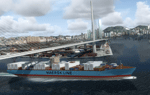
This package contains more than 600 AI ships and AI ship traffic routes for the entire globe for P3D and FSX. It is a stand-alone package comprising all my AI ship packages and fixes released until April 2016 including 86 new models released in 2016. The package includes cruise ships, ferries, container ships, oil tankers, bulk carriers, tall ships, fishing boats, destroyers, frigates, patrol boats, icebreakers and more. Many of the ships have helicopter platforms. You can land on all ships with an H painted on decks or hatches. Routes cover all mayor harbor cities including e.g. New York, Boston, Miami, Los Angeles, San Francisco, Vancouver, Seattle, Tokyo, Singapore, Hong Kong, Shanghai, Taoyuan, Manila, Jakarta, Sydney, Auckland, Ushuaia, Buenos Aires, Santos, Rio de Janeiro, Salvador, Panama, Chennai, Mumbai, Dubai, Cape Town, Lagos, Dakar, Las Palmas, Rotterdam, Amsterdam, London, Copenhagen, Aarhus, Gothenburg, Gibraltar, Barcelona, Istanbul, Marseille, Athens, Napoli, Bergen, Oslo, St. Petersburg, and many more. The package contains models, textures, and effects by Henrik Nielsen, Jean-Pierre Fillion, Erwin Welker, Knud Kristoffersen, Milton Shupe, Manfred Siedler, Bernardo Barroso, Paul Donnelly, Finn Kristoffer, Didier Puentes, Andrew Thomsen, Antonio Diaz, Sebastien Viale, Alberto Garcia, and Robystar.
| Filename: | Global_AI_Ship_Traffic_V1.zip |
| License: | Freeware |
| Added: | 1st April 2016, 08:35:36 |
| Downloads: | 23,266 |
| Author: | Henrik Nielsen |
| Size: | 424.03 MB |
| Category: Flight Simulator 2004 - Scenery | |
| OSM World: Western Europe |
|
Images related to this file:
File Description:
Read Installation instructions carefully, this is a complex scenery package!
This package includes a "Dev Kit" should you wish to expand it to other areas! Please contact me if you wish to do so! This is community effort! If we all contribute, we will hopefully have the entire world covered one day!
Welcome to OSM World: Western Europe! This is a vector data scenery package covering the western European area. Coastlines, Rivers, lakes, roads, railways, and power lines with detail never before seen! All in an autogen-compatible density! You can see roundabouts, train terminals, harbor areas in a resolution of a point every 10 meters. At this same resolution a vectorial city class places residential (in small and big building variations, depending on surface area) and industrial areas exactly where they are supposed to be. This gives the city areas a resolution far superior to the capacity of FS-2004 default landclass bitmaps, limited to approximately 1 Km x 1 Km squares. OSM World: Western Europe will even give you small roads leading to small towns (even a few houses across)! From big highway intersections, including ramps, to the tiniest rural pathways covering the entire western area! Wherever in Western Europe you fly, there is something to see!
| Filename: | OSM_World_Western_Europe.zip |
| License: | Freeware |
| Added: | 13th October 2014, 00:18:39 |
| Downloads: | 4,130 |
| Author: | Mario Noriega |
| Size: | 274.75 MB |
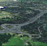
| Category: Flight Simulator 2004 - AFCAD Files | |
| Southwestern British Columbia Airport Corrections |
|
File Description:
As shorelines, water bodies, roads, railways and other features become more accurate in addon scenery, inaccuracies in airport placement become apparent. Although Microsoft did an excellent job of using published data to place airports, the published information is not always accurate. Some airports in the area of interest were misplaced by as much as 850m, thus conflicting with water and/or roadways. This release corrects Canadian airports in South-western British Columbia, in LOD5 cell 15x14 (915140). This area covers a portion of Vancouver Island from Duncan to Victoria, and the BC Mainland as far east as Douglas Lake and north of Pemberton. In this region CAK3, CAL3, CBT6, CYHE, CYLY, and CYPS are corrected, and Bruce Ellison has kindly modified his CAM3 for inclusion; see separate readme document for details. All these airports have been activated for AI use. A few buildings that may conflict from roads have been removed from CYNJ. The unrealistically large flatten and airport polygon at CYYJ is reduced in size. Airport features that end up in the water have been removed from CYVR and the overly large flatten there reduced. Some Rwy12 goodies have been tossed in as well, but if these are not important to the user, it is not necessary to have Rwy12 installed. Ultimate Terrain or similar accurate hydrology and roads recommended. FSGenesis 38m mesh or other high quality terrain mesh recommended.
| Filename: | Southwestern_British_Columbia_Airport_Corrections.zip |
| License: | Check within download |
| Added: | 30th May 2005, 07:31:45 |
| Downloads: | 3,001 |
| Author: | Jon Patch, Bruce Ellison |
| Size: | 1.53 MB |
| Category: Flight Simulator X - Scenery | |
| USCG Air Station Sitka PASI Scenery Package with AI Aircraft |
|
Images related to this file:
File Description:

Thanks to Airport Design Editor(ADE), Military AI Works (MAIW) scenery and aircraft, along with AI Flight Planner3 (AIFP3), I did my best to re-create USCG Air Station Sitka for FSX. Creating this airport scenery (along with Kodiak PADQ) was my first attempt at a BIG (for me) scenery project in ADE, but thanks to MAIW and their Global Scenery Library Objects, I think I've succeeded in re-creating the airbase. You'll need to go to MAIW's website and download that "Global Scenery" file for any of this to work, so I've copied that website link below (in STEP 1). I also added Sitka markings to all the AI helicopters for added realism.
And just for fun, I placed a USCG Cutter and a "fishing boat in distress" (complete with green smoke) out in the harbor as a "Practice Rescue Scenario". The Cutter has a "hard deck" to land on and I've also illuminated both it and the Fishing boat for DUSK and NIGHT practice.
*SPECIAL NOTE* THE AI C-130 in the pictures is from my Kodiak scenery package, there are only Helicopters based at Sitka...but I have it "fly in" from my Kodiak scenery package. So if you're interested in that, you can find the "USGC Air Station Kodiak AK PADQ Scenery Package with AI Aircraft" on AVSIM as well.
| Filename: | USCG_Air_Station_Sitka_PASI_Scenery_Package_with_A.zip |
| License: | Freeware |
| Added: | 31st January 2021, 06:43:13 |
| Downloads: | 1,078 |
| Author: | Daniel W Gregory |
| Size: | 16.58 MB |
| Category: Flight Simulator 2004 - Scenery | |
| Ulukhaktok (Holman) CYHI in the Northwest Territories, Canada |
|
Images related to this file:
File Description:
Ulukhaktok (Holman) is an airfield on the west side of Victoria Island, off the northern coast of Canada. It is 320 miles west of Cambridge Bay (and you should download and install the recent post of CYCB by Sid and Pete, as I use it for the AI included in this post) and around 400 miles east of Inuvik (my post of a few months ago). It has been officially called Ulukhaktok since 2006, and before that it's name was Holman.
The village of Ulukhaktok has been placed around the bay and is approximately the right shape; it houses some 460 people who used to rely solely on hunting and fishing. The village is close to 71 degrees north, and there are only four months of the year when the average high is above zero centigrade. The photograph with snow (and of course a frozen sea) is typical; for the frozen sea download my Frozen Rivers & Lakes post which will provide this. The buildings on the field have been modelled specifically for this scenery, and as in real life there is only JetA available. The AI visiting aircraft are an Aklak Air DC3 (based in Inuvik and operated by Kenn Borek Air) and a Canadian North Dash 8-100. Note that the runways are signed as "true" headings instead of magnetic; in the Canadian Northern Domestic Airspace all headings are given as true. Unfortunately FS9 doesn't accommodate this in ATC.
| Filename: | Ulukhaktok_Holman_CYHI_in_the_Northwest_Territorie.zip |
| License: | Freeware, limited distribution |
| Added: | 24th May 2011, 20:05:47 |
| Downloads: | 452 |
| Author: | Roger Wensley |
| Size: | 2.3 MB |
| Category: Prepar3D V1-4 - Scenery | |
| Mount Diablo Summit Museum |
|
Images related to this file:
File Description:
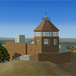
The museum and visitor center house a diorama of the parks ecosystems, complete with the sounds found in nature, and a topographic model of the mountain. On one wall, an instructional video and lighted display case describes the geologic forces that created the mountain. On anther wall, cultural history is chronicled with splendid photographs. The lower level of the summit building contains panels describing the Native American history of the region and an audio-visual room. Rotating displays of art and photography complement the permanent exhibits. In addition to the exhibits, there is a small gift center within the building.
| Filename: | Mount_Diablo_Summit_Museum.zip |
| License: | Freeware, limited distribution |
| Added: | 13th June 2016, 20:46:13 |
| Downloads: | 185 |
| Author: | Rick Keller |
| Size: | 1.08 MB |
| Category: Flight Simulator X - Aircraft Repaints, Textures and Modifications | |
| Douglas C-47 (VH-AGU) Adastra Aerial Surveys |
|
Images related to this file:
File Description:
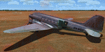
This folder contains a repaint for version 3.14 of the Douglas C-47 by Manfred Jahn and colleagues in the colors of C-47 VH-AGU of Adastra Aerial Surveys. It was originally constructed for the USAAF in 1944 as a C-47B-35-DK and allocated the military serial 44-76336. In February 1945 it was acquired by the RAAF and allocated the serial A65-72. Operated until 1959, it was then sold to Adastra Airways and converted for civil use. In October 1964 the aircraft was re-registered to Sepal Pty Ltd, but in October 1969 it was acquired by Adastra Aerial Surveys Pty Ltd. Adastra Aerial Surveys was acquired by East-West Airlines Ltd in April 1973 and VH-AGU was re-registered to East-West Airlines on 12 November 1974. East-West won the MLS trials support contract in December 1974 and VH-AGU was re-painted in East-West colours at Tamworth in the month prior to positioning at Melbourne/Essendon for the commencement of the contract on 25 January 1975. At some stage in the late 1970s the aircraft was transferred to South Coast Aviation, another East-West subsidiary. The aircraft was withdrawn from service in August 1979 at Essendon at the conclusion of its Departmental charter, and sold to Aerodyne Pty Ltd of Moorabbin. Since then, it has had several owners, and is still airworthy, flying in a USAF Vietnam war scheme from Morwell, Victoria. Repaint by Jan Kees Blom for Manfred Jahn's C-47 version 3.14, based on the paintkit by Gman5250.
| Filename: | Douglas_C47_VHAGU_Adastra_Aerial_Surveys.zip |
| License: | Freeware |
| Added: | 22nd August 2018, 15:12:21 |
| Downloads: | 192 |
| Author: | Jan Kees Blom |
| Size: | 15.68 MB |
| Category: Flight Simulator 2004 - Scenery | |
| Gjoa Haven CYHK, on King William Island, Nunavut, Canada, |
|
Images related to this file:
File Description:
Gjoa Haven is a village of 1,200 or so inhabitants at N 68 38 W 95 51 on the southeast corner of King William Island, around 155 miles north of the Arctic Circle. It's Inuit name is Uqsuqtuuq; the Gjoa Haven name was given by the Norwegian explorer Roald Amundsen when he spent two years there from 1903 to 1905 during his exploration of the northwest passage from east to west. His boat was called Gjoa and the cove was named Gjoa Harbour, in Norwegian. The village has been added in this scenery with approximately the right shape; though the coastline with Ultimate Terrain does have the small cove that serves as a harbor the coast shape is wrong. The airfield runway is 4,400 feet of gravel 100 feet wide at 154 feet above sea level. There is no LL100 available, only JetA1, delivered once a year by ship along with all the other requirements of the town. There is also a nearby CAM-B remotely operated defence radar station with its three protective domes. The old terminal building is still there, albeit repainted and spruced up, along with the far larger and newer one alongside it.
One of the screen shots shows Gjoa Haven as it appears for at least 8 months of the year, with snow on the ground and sea ice all around. If you want the ice then download my recent post of All Canada frozen lakes, rivers, and the northern seas, reversible with an untick in the FS scenery library.
| Filename: | Gjoa_Haven_CYHK_on_King_William_Island_Nunavut_Can.zip |
| License: | Freeware, limited distribution |
| Added: | 19th February 2011, 15:42:51 |
| Downloads: | 550 |
| Author: | Roger Wensley |
| Size: | 2.68 MB |
| Category: Flight Simulator 2004 - Scenery | |
| Naknek (5NK) and Naknek South (WSN) - Alaska, USA |
|
Images related to this file:
File Description:
Naknek and Naknek South are two towns close to the mouth of the Naknek River and on opposite banks. King Salmon is approximately 15 miles to the east. The canneries on both banks of the river are the reason for the existence of both towns and airfields, with fishing for salmon being the primary industry of the area. This takes place from the beach by individuals, by small boats in the river and the immediate sea area, and offshore by larger craft. There is a picture of one boat unloading in Naknek which will be known to anyone who has watched the most famous television fishing programme of all, Deadliest Catch. Cornelia Marie is better known for the crab fishing based in Dutch Harbor, but this area too is just as productive though without the drama. Naknek 5NK has two gravel runways and a float runway in the adjoining lake; all three are just under 2,000 feet long. Naknek South WSN has two gravel runways, 12-30 being 3,300 feet long and 04-22 2,260 feet. As the road connecting to King Salmon is on the north bank it is probable that more seasonal workers are brought into the southern canneries by air, hence the longer runway (and with PAPI on 12). Grant Aviation run scheduled flights into both and there are numerous seasonal charter flights. The AI is a further modification of that posted with King Salmon PAKN and includes these flights, and presumes that you have already downloaded PAKN.
| Filename: | Naknek_5NK_and_Naknek_South_WSN__Alaska_USA.zip |
| License: | Freeware, limited distribution |
| Added: | 29th April 2015, 20:44:31 |
| Downloads: | 214 |
| Author: | Roger Wensley |
| Size: | 6.09 MB |
© 2001-2026 AVSIM Online
All Rights Reserved
Privacy Policy |