
Where Flight Simulation Enthusiasts Gather from Around the World!
AVSIM Library - Search Results

| Category: Flight Simulator 2002 - Scenery | |
| Redding Municipal Airport.. Redding, CA |

|
File Description:
KRDD(Redding Municipal Airport) is located in the beautiful city of Redding Ca. Redding is a city located in Shasta County 150 mile's north of Sacramento on Interstate-5. Redding is known as a gateway for recreation for those visiting this Northern Ca. city, Lake Shasta and Mt Lassen are just a short drive out of town. As a former resident of Redding I drove past KRDD on a daily basis,on a couple of occasion's I had the opportunity to attend the annual Redding Airshow. The airshow play's host to many of aviations finest stunt pilot's as well as one of many military jet flying team's, the USN Blue Angels have been guest of the airshow many time's. The airshow still runs to this day. KRDD is also a destination city for several major and regional air carriers, HorizonAir and United Skywest are among them. This scenery I have done as a tribute to the many mile's I have put on driving past it as well as an opportunity to give it some dignity amongst the many airports in MSFS2002. This is also my first airport project I have released. My hope is that it adds to your FS2002 experience.
| Filename: | Redding_Municipal_Airport_Redding_CA.zip |
| License: | Freeware |
| Added: | 22nd November 2002, 04:37:21 |
| Downloads: | 621 |
| Author: | Randall R Smith |
| Size: | 557.2 KB |
| Category: Flight Simulator 2004 - Scenery | |
| CYHD - Dryden Regional - Ontario, Canada * Updated v2 * |
|
Images related to this file:
File Description:
This greatly modifies my previous (2009) post of Dryden; this version has bespoke buildings and is stand-alone and does not require you to have the previous post. There will also be follow-up posts of Sioux Lookout and Geraldton. Dryden is in northern Ontario, 110 miles east of the Manitoba border, 40 miles west of Sioux Lookout, and with the US border 90 miles to the south. The town is on the northern shore of Wabigoon Lake and has a population of around 7,800. The main business is pulp and paper, along with agriculture, tourism, and mining. The airport is 5 miles northeast of the town.
Dryden Regional has 6,000' of asphalt which in FS9 is aligned 11-29. The second runway is compacted sand 2,000' long and aligned 05-23. There are two aprons, the western being for the terminal building and some ga parking, and the eastern larger and used in the summer for parking fire fighting planes, along with maintenance hangarage and accomodation etc. The Ontario Fire Service planes were included with my original Geraldton post and are included here again; they fly back and forth and keep Dryden busy along with several Bearskin Airlines and Perimeter Aviation flights.
| Filename: | CYHD__Dryden_Regional__Ontario_Canada___Updated_v2.zip |
| License: | Freeware, limited distribution |
| Added: | 16th March 2013, 09:59:52 |
| Downloads: | 592 |
| Author: | Roger Wensley |
| Size: | 26.99 MB |
| Category: Flight Simulator X - Aircraft Repaints, Textures and Modifications | |
| VRS F-18E Superbug "TOP GUN MAVERICK" Repaint Textures |
|
Images related to this file:
File Description:
VRS F-18E Superbug "TOP GUN MAVERICK" Repaint Textures!
I "converted/painted over" one of the jets included in the Payware VRS SuperBug Package (VFA-14 LINE) and made it Maverick's New Super Hornet Ride...Sierra Hotel! Have fun turnin' and burnin' over China Lake, Fallon and thru the Mach Loop!
*** INSTALLATION ****
Copy and paste the "texture.TOP_GUN_MAVERICK" file into your
"FSX/SimObjects/Airplanes/VRS_FA-18E/" file
Add the following lines to your "aircraft.cfg" file...
[fltsim.xx]
title=TOP GUN MAVERICK
sim=FA-18E-6.8_SE
panel=
model=
texture=TOP_GUN_MAVERICK
kb_checklists=HTML/FA-18E-check
kb_reference=HTML/FA-18E-keys
ui_manufacturer=Boeing
ui_type=F/A-18E
ui_variation=TOP GUN MAVERICK
ui_typerole=Twin Engine Jet
ui_createdby=Vertical Reality Simulations
atc_heavy=0
atc_id=00
atc_airline=HORNET
atc_flight_number=00
atc_parking_types=MIL_COMBAT
description=
atc_parking_codes=M001
*************************************************************************
Special Thanks to VRS for making such an awesome aricraft to fly in FSX! The scenery I used in the promo pics (NAS FALLON B-17 weapons range) is courtesy of "Blue Sky Scenery".
On a personal note, painting airplanes for FSX has become a hobby of sorts for me during these difficult Covid-19 times, and it is my hope that my latest "Labor of Love" brings some happiness to your day!
Kick the Tires and Light the Fires!
Daniel Gregory
[email protected]
01-02-2021
| Filename: | VRS_F18E_Superbug_TOP_GUN_MAVERICK_Repaint_Texture.zip |
| License: | Freeware |
| Added: | 4th January 2021, 18:35:45 |
| Downloads: | 379 |
| Author: | Daniel W Gregory |
| Size: | 5.14 MB |
| Category: Flight Simulator 2004 - Scenery | |
| Lac des Plages grass strip in Quebec Canada |
|
Images related to this file:
File Description:
Lac des Plages is in Quebec on the north shore of the lake (and village) of the same name, some 55 miles northeast of Ottawa. It is an old grass strip and next to a tourist trailer park ("caravan" to the English). The runway is almost north-south and 2,200 feet long, and I went there to see if it is still in use. It is in good condition but there was nobody to ask (in early April) if it is still used and nobody turned up see if a plane had landed. I doubt if it is used regularly as there are no "wear" marks that show up on a grass strip, and the flare pots (actually old wheel rims with charcoal in them?) beside the runway could have been lit three months ago or three years ago, there was no way to tell. The single hangar is obviously no longer in use as a hangar, and the lack of a fence between the trailers and the grass strip would be a danger to pilot and strolling pedestrian alike. However, the runway still exists and here it is and as in real life the northern end slopes unevenly up.
| Filename: | Lac_des_Plages_grass_strip_in_Quebec_Canada.zip |
| License: | Freeware, limited distribution |
| Added: | 10th May 2010, 16:03:42 |
| Downloads: | 283 |
| Author: | Roger Wensley |
| Size: | 1.33 MB |
| Category: Flight Simulator 2004 - Scenery | |
| Rae Lakes CYRA at Gameti in the NW Territories Canada, corrected |
|
Images related to this file:
File Description:
This is a corrected version that rectifies the airfield elevation, which I forgot to include in the first post; 120 downloads and nobody tells me till now? The remainder of this is as first written, apart from the installation instructions: Gameti is a village in the Northwest Territories, around 65 miles north of Whati, which was recently posted. Until 2005 the village, which has a population of around 280, was known as Rae Lakes and the airfield is now renamed Gameti/Rae Lakes as shown in the 2010 version of the Nav Canada Flight Supplement, my standard reference year. Permanent settlement was established there in 1965 There is no all-weather road access and the village is reliant upon the airfield for supplies, along with an ice road in the winter months. The airfield is a mile or so east of the village, with a lit gravel runway of just over 3,000 feet aligned 14-32 and with PAPI at both ends. The airfield is served by Air Tindi from Yellowknife on an almost daily basis, included in the AI here along with some GA and a Friday delivery by a Buffalo DC3 that uses all of the runway. The runway has lake water at each end, ready for the unwary.
| Filename: | Rae_Lakes_CYRA_at_Gameti_in_the_NW_Territories_Can.zip |
| License: | Freeware, limited distribution |
| Added: | 30th November 2020, 18:04:00 |
| Downloads: | 135 |
| Author: | Roger Wensley |
| Size: | 3.9 MB |
| Category: Flight Simulator 2004 - Scenery | |
| Komakuk Beach & Storm Hills DEW sites in Yukon and Northwest Territories, Canada |
|
Images related to this file:
File Description:
These are DEW line sites in northern mainland Canada, to the west of Tuktoyaktuk.
Komakuk Beach CWKB is not included in FS9 and is in the Yukon, only 20 miles from the Alaska border. It is, as the name suggests, close to the sea, and the gravel runway 3,600' by 125' has its western end almost on the beach.
There is no lighting and no signage and the airfield is officially listed as closed, but in fact is used during the annual maintenance and refuelling of the automated NWS (North Warning Station) close by and for any unscheduled servicing. This replaced the previous much older DEW station that was manned year round and had a lot more buildings.
Storm Hills CWSH is in the Northwest Territories, 43 miles south-southwest of Tuktoyaktuk, up on higher land at 810 feet ASL. The NWS (there was no previous DEW station at this site) is serviced by helicopter from Tuktoyaktuk and has a gravel landing pad on the north side of the station. It will show on a gps and it is 5 miles west of the distinctively shaped and large Parsons Lake. This too was not in FS9.
| Filename: | Komakuk_Beach__Storm_Hills_DEW_sites_in_Yukon_and_.zip |
| License: | Freeware, limited distribution |
| Added: | 16th July 2012, 18:56:09 |
| Downloads: | 304 |
| Author: | Roger Wensley |
| Size: | 1.68 MB |
| Category: Flight Simulator 2004 - Scenery | |
| Montana Unleashed! - Part One |
|
Images related to this file:
File Description:
Montana Unleashed! Part 1 is the first in a two part series of a collection of airports in Montana. The majority of airports covered in Part 1 are located in the western half of the state. THIS IS A RE-UPLOAD OF A PREVIOUS UPLOADED SCENERY THAT WAS LOST DURING THE AVSIM HACK! NOTHING HAS CHANGED!
Montana Unleashed! is a collection of 14 highly detailed airports, created using Abacus' EZ-Scenery, scattered about the state of Montana and one in Washington. Do a ZipDive and check out some of the screenshots! The state of Montana, from what I've seen, seems to have been very neglected by scenery makers over the years which is surprising considering the beautiful and varied landscapes the state has to offer. There's some very cool approaches at many of these airports. The size of the airports vary from large all the way down to small county airports meaning you can fly just about any kind and size of aircraft with these sceneries. Fly your Delta 737 from Salt Lake to Bozeman. Fly your shiny new Skywest EMB-120 from Missoula to Billings. Or fly your Piper Cub from Havre City to Choteau and on to Dillon. It's all here!
| Filename: | Montana_Unleashed__Part_One.zip |
| License: | Freeware, limited distribution |
| Added: | 18th April 2010, 09:48:54 |
| Downloads: | 7,072 |
| Author: | Lauren Robison |
| Size: | 3.81 MB |
| Category: Flight Simulator 2004 - Scenery | |
| CYPE - Peace River - Northwest Alberta, Canada |
|
Images related to this file:
File Description:
The Peace River flows east from the Rockies, joining up with the Slave River to empty into Great Slave Lake. The town is on both banks close to a bend, 245 miles northwest of Edmonton. The population is 7,000 and the surrounding area is either farmland or forest and used for winter sports; Peace River hosted the 2004 Alberta Winter Games. The airport is just over 3 miles west of the town. The runway is 5,000 feet of wide asphalt (150 feet) aligned 04/22, lit, and with PAPI. There is a second runway to the south of the main runway, 1,900 feet of grass and aligned 08/26. The apron is to the north of the runway at the eastern end and is large; there is a purpose-built terminal building, plus other hangar buildings along taxiway C that extends westward from the apron. The airport gives the impression that it is under-used; there are no long lines of parked planes waiting for the weekend and few scheduled flights. These are mainly (totally?) by Sunwest Home Aviation, but unfortunately nobody has made the textures for Sunwest and my talents do not run in that direction so I have made believable substitutions. There is also a small but obstinate AI difficulty, described in the notes.
| Filename: | CYPE__Peace_River__Northwest_Alberta_Canada.zip |
| License: | Freeware, limited distribution |
| Added: | 10th November 2013, 23:56:22 |
| Downloads: | 332 |
| Author: | Roger Wensley |
| Size: | 10.83 MB |
| Category: Flight Simulator 2004 - Scenery | |
| Mountain View CPZ3 in Ontario, Canada |
|
Images related to this file:
File Description:
This is Mountain View, a small RCAF airfield at the eastern end of Lake Ontario on Prince Edward Island, some 40 miles west of Kingston. Mountain View is used for training during the summer months, and part of this training is for C-130 crews, who practice landing on rough or unprepared landing strips. The crews are based at Trenton, which is a large base 10 miles to the northwest on the mainland. There are (or were, I haven't seen it recently) numerous parked and ancient fighter planes such T-33's and Canadair Tutors; these could also have possibly been used for summer training or perhaps were just stored. Last summer there were only two hangars left standing; in 2002 there were five. In real life you would be on the lookout not only for C-130's but also (at certain times during the summer) for parachutists and also gliders. This airfield is one that you will fly over and not land on; I confess that I have cheated with the length of the 06L-24R gravel "practice" runway, so that it became possible for the FS version of a touch-n-go with a C-130 to be completed without using the grass. The aerial photograph shows the new "practice" gravel runway under construction.
| Filename: | Mountain_View_CPZ3_in_Ontario_Canada.zip |
| License: | Freeware, limited distribution |
| Added: | 9th March 2012, 15:05:57 |
| Downloads: | 350 |
| Author: | Roger Wensley |
| Size: | 7.26 MB |
| Category: Prepar3D V1-4 - Scenery | |
| POLISH AIRPORTS VOL. 3 X DEMO |
|
Images related to this file:
File Description:
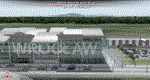
POLISH AIRPORTS VOL. 3 X DEMO is a package of detailed sceneries of EPPO Poznan, EPWR Wroclaw, EPBY Bydgoszcz and EPSY Olsztyn-Mazury airports in Poland, fully compatible with FSX, FSX:SE and P3D (v1,v2,v3,v4).
This product is a fully functional DEMO version of the commercial payware product that features simplified airports with main buildings but with low resolution textures, non-animated jetways and generally much less details. Using this free demo ensures no problems with online (VATSIM, IVAO, multiplayer etc.) flying in case some users use the payware scenery and some don't.
Poznan-Lawica Henryk Wieniawski Airport (POZ/EPPO), built in 1913, is one of the oldest airports in Poland. Bydgoszcz Ignacy Jan Paderewski Airport (BZG/EPBY) is a Polish regional airport in the city of Bydgoszcz. Wroclaw Copernicus Airport (WRO/EPWR) is an international commercial airport in Wroclaw in southwestern Poland, the 4th largest airport in Poland. Olsztyn-Mazury Airport (SZY/EPSY) is an international passenger airport in the North-East of Poland, branded as the gateway to the Masurian Lake District.
The product is equipped with an automatic installer, which means that the scenery will be automatically added to the Flight Simulator Scenery Library. Please uninstall all previous versions of this airport you may have installed before. Please make also sure that no duplicated AFCAD files are installed.
Enjoy your virtual flying with Drzewiecki Design!
| Filename: | POLISH_AIRPORTS_VOL_3_X_DEMO.zip |
| License: | Freeware, limited distribution |
| Added: | 27th July 2018, 00:06:20 |
| Downloads: | 341 |
| Author: | Drzewiecki Design |
| Size: | 20.81 MB |
© 2001-2026 AVSIM Online
All Rights Reserved
Privacy Policy |