
Where Flight Simulation Enthusiasts Gather from Around the World!
AVSIM Library - Search Results

| Category: Flight Simulator 2004 - Scenery | |
| North Haledon |

|
File Description:
North Haledon is a small town in Northern New Jersey, USA. This is Chopper Friendly scenery, folks. It wasn't designed to be flown over at 10,000 feet - although, if you like to fly heavy iron into the major New York/New Jersey airports, you'll notice that it replaces the terrain elevation of Northern New Jersey with all the hills and valleys that the default scenery left out. No, this is interactive scenery. Built to be explored low and slow. Want to perfect your landing skills in a huge playground of rooftops, irregular terrain, and tight spaces? This is the place. You won't find any unlandable surfaces or false crashes here - just hundreds of places to touch down ranging from beginner, through expert, to downright sick! There's a police station with landable helipad, four schools, ballfields, an optional forest fire (with a scenic lake nearby for refilling), too many highly detailed houses and buildings to count, and much more.
| Filename: | North_Haledon.zip |
| License: | Freeware, limited distribution |
| Added: | 25th April 2006, 02:48:26 |
| Downloads: | 1,924 |
| Author: | Mick Posch |
| Size: | 13.14 MB |
| Category: Flight Simulator 2004 - Scenery | |
| High Prairie CZHP in Alberta, Canada |
|
Images related to this file:
File Description:
High Prairie is at 1,974 feet asl, 15 miles west of Lesser Slave Lake, 70 miles southeast of Peace River CYPE, and 90 miles east of Grande Prairie CYQU (both already posted). The town has a population of around 2,600 and is based on agriculture, forestry, and oil and gas. The initial impetus behind its growth was the routing of the railroad in 1914. The airport is around 2 miles south of the town, and is fairly basic. There is a single runway just under 4,000 feet of asphalt aligned 07-25. There is a daily flight and around 2010 this was by Central Mountain Air. I believe that there is now a newer terminal building, but a lack of information leaves the older one in place here. There are runway and taxiway lights, unlike some of my recent posts. I made this to fill in the gap between Edmonton and the airports to the northwest such as Grande Prairie.
| Filename: | High_Prairie_CZHP_in_Alberta_Canada.zip |
| License: | Freeware, limited distribution |
| Added: | 9th December 2018, 17:21:09 |
| Downloads: | 119 |
| Author: | Roger Wensley |
| Size: | 3.16 MB |
| Category: Flight Simulator 2002 - Miscellaneous Files | |
| Las Vegas Sectional Chart |
|
File Description:
If you plan a virtual flight to some of the States´ most beautiful National Parks, this chart is for you. The 5300*4200 pixel chart merges the front and back of the Las Vegas sectional and covers Las Vegas, the Grand Canyon, Bryce Canyon, Death Valley, Lake Mead, Marble Canyon... The desert states have a lot to offer! Take off from Richard "Georender" Goldstein´s Escalante and aim for Hurricane, at Bryce Canyon (KBCE) you may have a soft drink and practice high altitude take-offs and landings. While it can be used "as is" without any other software, it will develop its full potential if used as moving map with SimSystem´s FSFlightMax or FSGarmin. It wouldn´t have been possible to offer this chart without Richard Harvey and his love to flightsimming, so please consider this file to be "donationware" and make a however small contribution to the Richard Harvey Endowed Scholarship.
| Filename: | Las_Vegas_Sectional_Chart.zip |
| License: | Check within download |
| Added: | 24th March 2003, 13:41:22 |
| Downloads: | 2,031 |
| Author: | Uwe Rademacher |
| Size: | 15.23 MB |
| Category: Flight Simulator 2004 - Scenery | |
| Misty Moorings DynaScene Scenario - 08/18/2005 |
|
File Description:
DynaScene scenario based scenery file for Misty Moorings members and other interested parties. (Misty Fjords Scenery from www.fsaddon.com required). Provides background text, photos, and scenery for a temporary scenario. Story as follows: NEWS FLASH! 08/18/2005 - BUSH PILOT GROUNDED PENDING INVESTIGATION - KETCHIKAN (APX) - The alaska wilderness is no stranger to strange tales. At least that's how it appears in the case of a local bush pilot, Randy Morgan, who had quite a large one to tell.
At 6 PM on the evening of the 16th, Randy and one passenger took off in a Cessna 182RG from Maloney's Tavern on his way back to Ketchikan. "The weather was good and I had no idea what was about to happen" said Randy Morgan. "We had planned our flight to pass over Raptor's Roost and Punchbowl Lake before heading into Ketchikan when I saw it." (full text in download) - Makes use of Rwy12 libraries by Seev Kahn and Glen Gordon (included in download).
| Filename: | Misty_Moorings_DynaScene_Scenario__08182005.zip |
| License: | Freeware |
| Added: | 22nd August 2005, 01:04:19 |
| Downloads: | 968 |
| Author: | Glen Gordon (Professor Khaos) |
| Size: | 4.76 MB |
| Category: Flight Simulator 2004 - Scenery | |
| Fourth of July Fireworks Part 3 Complete Final |
|
File Description:
This is the third and final part of my Fourth of July Fireworks scenery. All 3 parts are included in this file. It will add Fourth of July Fireworks to the following cities: Columbus, Boston, Philadelphia, New York, Washington DC, Atlanta, Orlando, Tampa, Miami, Key West, Chicago, St Louis, Seattle, Portland, San Francisco, Oakland, Los Angeles, San Diego, Pittsburgh, Buffalo, Cleveland, Detroit, Phoenix, Albuquerque, Dallas, Houston, Kansas City, Milwaukee, Denver, Salt Lake City, Nashville, Bangor, Portland(me), Concord(nh), Manchester(nh), Burlington(vt), Montpelier, Hartford, Providence, Albany, Syracuse, Harrisburg, Erie, Dover, Trenton, Baltimore, Charleston(wva), Richmond, Raliegh, Charlotte, Columbia, Charleston(sc), Savannah, Jacksonville, Tallahassee, Pensacola, Mobile, Birmingham, Jackson(ms), Knoxville, Memphis, Louisville, Chatham(ma), Provincetown(ma), Marthas Vinyard, Nantucket, San Antonio, Cincinnati, Dayton, Toledo, Indianapolis, Minneapolis, Des Moines, Little Rock, New Orleans, Austin, El Paso, Oklahoma City, Wichita, Omaha, Sioux Falls, Pierre, Bismarck, Butte, Helena, Casper, Jackson Hole, Tucson, Boise, Spokane, Eugene, Aspen, Hilo, Honolulu, Fairbanks, Anckorage, and Juneau.
| Filename: | Fourth_of_July_Fireworks_Part_3_Complete_Final.zip |
| License: | Freeware |
| Added: | 1st July 2006, 00:08:36 |
| Downloads: | 3,835 |
| Author: | Gregg Wolfram |
| Size: | 199.46 KB |
| Category: Navigation and ATC - Navigation | |
| Twin Cities Sectional Chart Chunks for Aerosoft's FSMap |
|
File Description:
Sectional chart chunks made from the August 2009 Sectional charts at the original scale, formatted in the WGS84 lat/long geographic coordinate system for the FSMap, moving map application for flight simulation use.
The chart chunks are the full sectional divided by 2 tiles (east/west) and converted from the geotiffs to baseline 8bit tiffs with packbit compression applied, not for size but for efficiency. The images are about 6,000x6,000 pixels at about 25mb each, also included is the FSMap fsm Calibration file for importing.
**Note: The files in this download are the largest of the split sectionals, 6,000x7,000 due to the Lake of the Woods region extending the northern border. These should work in the gauge just fine, having tested the full sectional area tiff that is 12,000x7,000 at 60mb in size in the gauge the only difference was that the zoom in was limited to 10nm with these larger images (see the notes in the zip file).
| Filename: | Twin_Cities_Sectional_Chart_Chunks_for_Aerosofts_F.zip |
| License: | Freeware |
| Added: | 19th March 2010, 01:17:18 |
| Downloads: | 334 |
| Author: | David Myers |
| Size: | 34.27 MB |
| Category: Flight Simulator X - AFCAD Files | |
| Tamchy Airport Kyrgyzstan (UAFL) |
|
File Description:
Tamchy Airport (ICAO: UAFL) is an airport in Kyrgyzstan.
This AFCAD file for FSX adds a taxiway, apron, 3 parking spots and some generic buildings and other airport objects to the standard FSX Tamchy airport.
Although this airport has been designed roughly from looking at Google Earth/Maps, this is by no means 100% realistic. The buildings are all placed randomly by me, just to make it more interesting. Same story for the fuel tanks, trees, and vehicles. However, I did keep the proportions realistic, i.e. you won't land or park an A380 here.
In FSX, this is an awesome airport, right next to the massive Issyk-Kul lake which is one of the largest in the world. The scenery (even the standard FSX scenery) is just awesome. Hop into a turboprop plane, plan a flight between this airport and Bishkek or Almaty, and off you go.
This airport is served by Central Asian Airlines VA - www.flycentralasian.com
| Filename: | Tamchy_Airport_Kyrgyzstan_UAFL.zip |
| License: | Freeware |
| Added: | 22nd March 2012, 04:07:05 |
| Downloads: | 252 |
| Author: | Peter Wouters |
| Size: | 3.41 KB |
| Category: Flight Simulator 2004 - Aircraft Repaints, Textures and Modifications | |
| Futura Airlines Lockheed L-049 Constellation |
|
Images related to this file:
File Description:
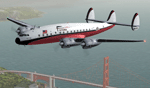
Textures for the Lockheed L-049 Constellation by the team Roland Berger, Volker Boehme, Manfred Jahn, Luis Pallas, Bill Tyne and Stefan Werner. Repaint by Manfred Meyer.
The company Nevada Airmotive bought TWA's L-049 fleet in 1962 for lease and/or resell them. But only fife of the 25 Constellations found new operators .
One of these aircrafts was c/n 2075, built 1946 and delivered to Air France as F-BAZD.Sold 1950 to TWA, reg. as N9414H, named "Star of Lebanon". Sold to Nevada Airmotive in 1962 and leased to Futura Airlines Inc. Oakland, CA. This Company was short lived - flights startet from Oakland to Lake Tahoe, but operations ceased a few month later and the Constellation went to Paradise Airlines. In 1964 she was sold to Pasco Avn. Inc. later to Zephyr Hills Inc. and stored at Miami, FL, 1947 leased to Quisqueyana Dom. Rep.ans subsequently scrapped at Miami 1970.
| Filename: | Futura_Airlines_Lockheed_L049_Constellation.zip |
| License: | Freeware |
| Added: | 11th July 2015, 11:26:23 |
| Downloads: | 130 |
| Author: | Manfred Meyer |
| Size: | 4.14 MB |
| Category: Flight Simulator 2004 - Scenery | |
| Turangi Airfield, New Zealand. NZTN. Version-2 UPDATE and FIX. |
|
File Description:
Welcome to Turangi Airfield, 1nm North of the township of Turangi, at the southern end of the
beautiful Lake Taupo, in the central North Island of New Zealand.
The airfield is home to the Turangi Aero Club, and is served by Mountain Air, undertaking tourist flights
around the National Park and central North Island volcanoes, and flights to the Chateau and skifields
at Mount Ruapehu.
This scenery is built to fit into the freeware "Turangi" photoreal area scenery by Robin Corn, freely available
from avsim.com, filename...... godzoneturangi.zip .
This version corrects an error i made in the first scenery, when i accidentally mixed some pictures of another airfield
in with the Turangi pictures i was using for building. It corrects the type of buildings, and their locations on the airfield.
Update also adds a few other detail changes and additions.
This is a TOTAL replacement for my previous scenery. Requires some EZ Scenery Object Sets (see INSTALL instructions for details).
| Filename: | Turangi_Airfield_New_Zealand__NZTN__Version2_UPDAT.zip |
| License: | Freeware, limited distribution |
| Added: | 13th November 2008, 12:52:09 |
| Downloads: | 733 |
| Author: | Lawrie Roache |
| Size: | 549.77 KB |
| Category: Flight Simulator 2004 - Scenery | |
| Ontario Small Fields in Canada: #04 Stoney Point (Le Cunff) CRML V1 |
|
Images related to this file:
File Description:
This is the fourth in a series of small airfields in southern Ontario, Canada. It is Stoney Point (Le Cunff) CRML, a field near a small town (Stoney Point) close to Lake St Clair. The airfield has a grass runway of 2,250 feet, aligned 18/36; with trees around the house gardens between road and runway the south threshold is displaced by 250 feet. The markers approximately show the touchdown point north of the runway end. Le Cunff is the family name of the owners, included to differentiate between this and another Stoney Point field, CRJ2. I found the default FS9 airfield at the correct elevation of 625 feet, but sitting on a plateau, despite my Genesis Mesh. This looked so unreal that I have revised this to an incorrect lower elevation of 580. So if you find the airfield sitting in a hole in your installation you now know the reason. Let me know, with a screenshot please.
| Filename: | Ontario_Small_Fields_in_Canada_04_Stoney_Point_Le_.zip |
| License: | Freeware, limited distribution |
| Added: | 29th July 2015, 16:08:32 |
| Downloads: | 146 |
| Author: | Roger Wensley |
| Size: | 1.6 MB |
© 2001-2026 AVSIM Online
All Rights Reserved
Privacy Policy |