
Where Flight Simulation Enthusiasts Gather from Around the World!
AVSIM Library - Search Results

| Category: Flight Simulator 2004 - Miscellaneous Files | |
| Active ILS - EFHK (Helsinki - Vantaa Aerodrome) |

|
File Description:
As most know initiating the ILS at certain airports for AI Traffic is not a function at this time when using AFCAD2. If you add a new ILS runway to an airport such as EFHK (Helsinki - Vantaa 4L/22R) only the user aircraft can use this runway when visibility falls below 3 miles. ATC will no longer use this runway for AI Traffic because FS9 sees it as a visual runway. This will cause ATC to vector all your AI Traffic back to 4R/22L which is also a Terminal departure runway. This bgl file adds all NAVAIDS for making 4L/22R a Precision Instrument Runway by adding all the radar fixes for both the ILS approach portion and the missed approach procedures, altitudes and intersections as per current published plates. All AI Aircraft will now continue to use 4L/22R when Airport weather conditions are less than 3 miles.
*** FISD Finnish Scenery Designers and FS2004 Default Scenery AFCAD's included ***
| Filename: | Active_ILS__EFHK_Helsinki__Vantaa_Aerodrome.zip |
| License: | Freeware, limited distribution |
| Added: | 5th August 2004, 16:56:59 |
| Downloads: | 2,133 |
| Author: | Jim Vile |
| Size: | 27.25 KB |
| Category: Flight Simulator 2004 - Panels | |
| 737 757 767 777 VRIF GG PANEL v13 |
|
File Description:
This is Greetmir Goodeguard's modification of Ken Mitchell's great Boeing 757 panel. He has made these modifications to comply with his "VRIF" criteria. (Visibility Readablility Information & Functionality) This panel has been thoroughly tested and is believed it to be totally funtional as well as VERY FSNAV friendly.
Although this panel modification is designed to be an ideal panel for the Boeing 767 series, it surely can be used in any two engine jet especially Boeing 737's, 757's and 777's. Features of this panel include Ken Mitchell's super PFD and MFD gauges, Eric Mariciano's excellent sweep-hand TCAS Radar Gauge. Bob Guy's very informative Fuel Statistics Gauge and the MSFS 2004 GPS System.
This is a stand-alone panel with all files, gauges, bitmaps and installation as well as PFD and MFD use instructions included. This panel is intended for FS2004 (FS9) and has NOT been tested on FS2002 or FS2000.
| Filename: | 737_757_767_777_VRIF_GG_PANEL_v13.zip |
| License: | Freeware |
| Added: | 4th January 2006, 14:45:40 |
| Downloads: | 74,697 |
| Author: | Greetmir Goodeguard |
| Size: | 22.76 MB |
| Category: Flight Simulator 2004 - Scenery | |
| Himalayan Peaks LOD10 Mesh, Volume 1 - Mt. Everest and Kula Kangri |
|
File Description:
Highly detailed terrain mesh of the Mt. Everest and Kula Kangri areas, N26°-29° E85°-92°. The files in this package are based on Shuttle Radar (SRTM) Version 2 data but with many of the void areas, especially the most significant sections, filled with elevation data generated from topographic maps by Jonathan de Ferranti. While Jonathan's work is unrelated to flight simulation he kindly gave me permission to compile his data for use in FS. The result is a wonderful improvement in detail and accuracy over any existing mesh file, freeware or commercial, based on SRTM or DTED data alone. Due to the large area of the Himalayas I've compiled the source data as two separate series: the "Himalayan Peaks" series covers prominent mountains and ranges in higher detail and locally overrides any existing LOD9 terrain mesh. In addition, a LOD9 "base mesh" series covering the entire Himalayas will be available for those who do not yet have an add-on terrain mesh of these beautiful mountains.
| Filename: | Himalayan_Peaks_LOD10_Mesh_Volume_1__Mt_Everest_an.zip |
| License: | Freeware, limited distribution |
| Added: | 9th February 2006, 22:13:00 |
| Downloads: | 37,043 |
| Author: | Holger Sandmann and Jonathan de Ferranti |
| Size: | 52.01 MB |
| Category: Flight Simulator 2004 - Scenery | |
| "Himalayan Peaks" LOD10 Mesh, Volume 3 - Namcha Barwa |
|
File Description:
Highly detailed terrain mesh of the Namcha Barwa area, N29°-31° E94°-96°. The files in this package are based on Shuttle Radar (SRTM) Version 2 data but with many of the void areas, especially the most significant sections, filled with elevation data generated from topographic maps by Jonathan de Ferranti. While Jonathan's work is unrelated to flight simulation he kindly gave me permission to compile his data for use in FS. The result is a wonderful improvement in detail and accuracy over any existing mesh file, freeware or commercial, based on SRTM or DTED data alone. Due to the large area of the Himalayas I've compiled the source data as two separate series: the "Himalayan Peaks" series covers prominent mountains and ranges in higher detail and locally overrides any existing LOD9 terrain mesh. In addition, a LOD9 "base mesh" series covering the entire Himalayas will be available for those who do not yet have an add-on terrain mesh of these beautiful mountains.
| Filename: | Himalayan_Peaks_LOD10_Mesh_Volume_3__Namcha_Barwa.zip |
| License: | Freeware, limited distribution |
| Added: | 18th February 2006, 23:15:17 |
| Downloads: | 12,186 |
| Author: | Holger Sandmann and Jonathan de Ferranti |
| Size: | 15.09 MB |
| Category: Flight Simulator 2004 - Scenery | |
| "Himalayan Peaks" LOD10 Mesh, Volume 4 - Annapurna |
|
Images related to this file:
File Description:

Highly detailed terrain mesh of the Annapurna area, N28-30 E83-85. The files in this package are based on Shuttle Radar (SRTM) Version 2 data but with many of the void areas, especially the most significant sections, filled with elevation data generated from topographic maps by Jonathan de Ferranti. While Jonathan's work is unrelated to flight simulation he kindly gave me permission to compile his data for use in FS. The result is a wonderful improvement in detail and accuracy over any existing mesh file, freeware or commercial, based on SRTM or DTED data alone.
Due to the large area of the Himalayas I've compiled the source data as two separate series: the "Himalayan Peaks" series covers prominent mountains and ranges in higher detail and locally overrides any existing LOD9 terrain mesh. In addition, a LOD9 "base mesh" series covering the entire Himalayas will be available for those who do not yet have an add-on terrain mesh of these beautiful mountains.
| Filename: | Himalayan_Peaks_LOD10_Mesh_Volume_4__Annapurna.zip |
| License: | Freeware, limited distribution |
| Added: | 29th May 2010, 08:59:29 |
| Downloads: | 10,461 |
| Author: | Holger Sandmann, Jonathan de Ferranti |
| Size: | 15.07 MB |
| Category: Flight Simulator 2004 - Scenery | |
| "Himalayan Peaks" LOD10 Mesh, Volume 5 - Garhwal |
|
File Description:
Highly detailed terrain mesh of the Garhwal area, N30°-32° E78°-81°. The files in this package are based on Shuttle Radar (SRTM) Version 2 data but with many of the void areas, especially the most significant sections, filled with elevation data generated from topographic maps by Jonathan de Ferranti. While Jonathan's work is unrelated to flight simulation he kindly gave me permission to compile his data for use in FS. The result is a wonderful improvement in detail and accuracy over any existing mesh file, freeware or commercial, based on SRTM or DTED data alone. Due to the large area of the Himalayas I've compiled the source data as two separate series: the "Himalayan Peaks" series covers prominent mountains and ranges in higher detail and locally overrides any existing LOD9 terrain mesh. In addition, a LOD9 "base mesh" series covering the entire Himalayas will be available for those who do not yet have an add-on terrain mesh of these beautiful mountains.
| Filename: | Himalayan_Peaks_LOD10_Mesh_Volume_5__Garhwal.zip |
| License: | Freeware, limited distribution |
| Added: | 18th February 2006, 23:16:47 |
| Downloads: | 10,132 |
| Author: | Holger Sandmann and Jonathan de Ferranti |
| Size: | 27.72 MB |
| Category: Flight Simulator 2004 - Scenery | |
| "Himalayan Peaks" LOD10 Mesh, Volume 7 - K2 and Karakoram |
|
Images related to this file:
File Description:

Highly detailed terrain mesh of the Karakoram area, N35-37 E73-77. The files in this package are based on Shuttle Radar (SRTM) Version 2 data but with many of the void areas, especially the most significant sections, filled with elevation data generated from topographic maps by Jonathan de Ferranti. While Jonathan's work is unrelated to flight simulation he kindly gave me permission to compile his data for use in FS. The result is a wonderful improvement in detail and accuracy over any existing mesh file, freeware or commercial, based on SRTM or DTED data alone.
Due to the large area of the Himalayas I've compiled the source data as two separate series: the "Himalayan Peaks" series covers prominent mountains and ranges in higher detail and locally overrides any existing LOD9 terrain mesh. In addition, a LOD9 "base mesh" series covering the entire Himalayas will be available for those who do not yet have an add-on terrain mesh of these beautiful mountains.
| Filename: | Himalayan_Peaks_LOD10_Mesh_Volume_7__K2_and_Karako.zip |
| License: | Freeware, limited distribution |
| Added: | 30th May 2010, 09:56:27 |
| Downloads: | 9,475 |
| Author: | Holger Sandmann, Jonathan de Ferranti |
| Size: | 38.58 MB |
| Category: Flight Simulator 2004 - Scenery | |
| "Himalayan Peaks" LOD10 Mesh, Volume 6 - Jammu and Kashmir |
|
Images related to this file:
File Description:
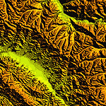
Highly detailed terrain mesh of the Jammu and Kashmir areas, N31-36 E76-78. The files in this package are based on Shuttle Radar (SRTM) Version 2 data but with many of the void areas, especially the most significant sections, filled with elevation data generated from topographic maps by Jonathan de Ferranti. While Jonathan's work is unrelated to flight simulation he kindly gave me permission to compile his data for use in FS. The result is a wonderful improvement in detail and accuracy over any existing mesh file, freeware or commercial, based on SRTM or DTED data alone.
Due to the large area of the Himalayas I've compiled the source data as two separate series: the "Himalayan Peaks" series covers prominent mountains and ranges in higher detail and locally overrides any existing LOD9 terrain mesh. In addition, a LOD9 "base mesh" series covering the entire Himalayas will be available for those who do not yet have an add-on terrain mesh of these beautiful mountains.
| Filename: | Himalayan_Peaks_LOD10_Mesh_Volume_6__Jammu_and_Kas.zip |
| License: | Freeware, limited distribution |
| Added: | 29th May 2010, 08:55:43 |
| Downloads: | 9,664 |
| Author: | Holger Sandmann, Jonathan de Ferranti |
| Size: | 52.19 MB |
| Category: Flight Simulator 2004 - Panels | |
| Bristol Britannia |
|
File Description:
A highly detailed and comprehensive panel designed for Mike Stone's Bristol
Britannia aircraft. In addition to the standard instrumentation, includes cabin
announcements, traffic radar, fuel management etc.
Also requires a) FSUIPC (the latest version is always available at http://www.schiratti.com/dowson.html and is essential for the operation of some of the gauges in this panel), b) (optional) Flight Deck Sound Effects available here at AVSIM - fdsfxpnl.zip, and c) (optional) GPWS Altitude Call-Out Sounds available here at AVSIM - fpda_a330_callout.zip.
The manual is available in plain text format in this main download, or you can download an illustrated manual separately from the same download site in PDF format (britpanm.zip).
This is the result of over eighteen months of development and has been produced
specifically as a thankyou to all the people that have produced free add-ons that I have benefitted from.
I hope this enhances the pleasure of flying the only British-built long long-range turboprop airliner.
| Filename: | Bristol_Britannia.zip |
| License: | Freeware |
| Added: | 30th November 2004, 01:15:55 |
| Downloads: | 2,434 |
| Author: | John Hinson |
| Size: | 9.41 MB |
| Category: Flight Simulator 2004 - Panels | |
| Boeing 737 700/800/900 Series |
|
File Description:
If you're a keen flight Simmer like myself you strive for realism - you have found the most detailed favourite aircraft in your airline colours - you have downloaded accurate scenery and AFCAD files for your flying area, but when it comes time to fly, the realism is shattered because your aircraft's panel looks 'comic book' or far from the real thing. It is with this in mind that I developed this final version of my previously designed 737 700/800 panel. Although it is hard to accurately position every gauge and function of the real panel into the sim one - because of size constraints I believe this panel is as realistic as is possible. You have the glass 'usuals' HSI, EICAS, FMS, NAv AI TRAFFIC RADAR as well as the stanby 'steam' gauges. I have tried to rework the photoreal panel bitmap with appropriate graphics to achieve shadowing. I hope you enjoy using it.
| Filename: | Boeing_737_700800900_Series.zip |
| License: | Freeware |
| Added: | 27th February 2006, 14:13:01 |
| Downloads: | 30,100 |
| Author: | Steve Southey |
| Size: | 10.18 MB |


© 2001-2026 AVSIM Online
All Rights Reserved
Privacy Policy |