
Where Flight Simulation Enthusiasts Gather from Around the World!
AVSIM Library - Search Results

| Category: Flight Simulator X - Scenery | |
| FSX - Barnstable Municipal Airport KHYA |

|
Images related to this file:
File Description:
FSX Scenery - Barnstable Municipal Airport (IATA: HYA, ICAO: KHYA, FAA LID: HYA), also known as Boardman/Polando Field, is a public airport located on Cape Cod, one mile (1.6 km) north of the central business district of Hyannis, in Barnstable County, Massachusetts, United States. This airport is publicly owned by the Town of Barnstable. It is Cape Cod's major airport as well as an air hub for the Cape and the Islands (Martha's Vineyard and Nantucket). The airport is served by scheduled commercial flights as well as charters and general aviation. This is a total re-do of my FS9 scenery. For you flight sim flying pleasure by John B. Loney, Jr.
| Filename: | barnstable_municipal_khya_fsx_2017.zip |
| License: | Freeware, limited distribution |
| Added: | 19th March 2017, 18:23:44 |
| Downloads: | 652 |
| Author: | John B. Loney, Jr. |
| Size: | 36.46 MB |
| Category: Flight Simulator X - Scenery | |
| YPLU Plutonic Gold Mine, Peak Hill, Western Australia |
|
File Description:
The Plutonic Gold Mine is located 82 km east north east of Peak Hill, Western Australia. It is operated by Barrick Gold and located at the Plutonic Well Greenstone Belt. In 1988, Great Central Mines discovered the deposit which was to become Plutonic, which the company sold for A$50 million. The site was then owned by Plutonic Resources, a major Australian gold mining and exploration company. Homestake Mining Company purchased Plutonic in April 1998 for more than $1.0 billion, and, in turn, Homestake was acquired by Barrick Gold at the end of 2001. REQUIRES Blencowe_LibraryKit.zip
REQUIRES blencowe_librarykit_309494.zip (Available HERE)
| Filename: | blencowe_plutonicmine.zip |
| License: | Freeware |
| Added: | 28th February 2013, 14:00:30 |
| Downloads: | 245 |
| Author: | Alan Blencowe |
| Size: | 10.21 MB |
| Category: Flight Simulator X - Scenery | |
| 17Z - Manakotak Airport - Alaska |
|
Images related to this file:
File Description:
Manokotak Airport (IATA: KMO, ICAO: PAMB, FAA LID: MBA, formerly 17Z) is a state-owned public-use airport located one mile (2 km) north of the central business district of Manokotak, a city in the Dillingham Census Area of the U.S. state of Alaska.
Increased runway 3/21 from 3,300 feet to 4,000 feet. Added aditional aprons and custom buildings. Changes are based on 2006 construction plans.
Created with Airport Design Editor 9x by ScruffyDuck Software using current FAA documentation and Google Earth measurements, this package offers a replacement for FSX's stock airport. All these enhancements are as close to the real airport as I can get with stock library objects and custom buildings.
| Filename: | 17zairport.zip |
| License: | Freeware |
| Added: | 16th January 2015, 20:14:02 |
| Downloads: | 772 |
| Author: | Wayne Roberts |
| Size: | 64 KB |
| Category: Flight Simulator X - Scenery | |
| KFKN - Franklin Municipal / John Beverly Rose Airport - Virginia, USA |
|
File Description:
Also known as Franklin Municipal Airport or John Beverly Rose Field (IATA: FKN, ICAO: KFKN, FAA LID: FKN) is a public airport in Isle of Wight County, Virginia, United States. The airport is owned by the City of Franklin and is located at 32470 John Beverly Rose Drive, two nautical miles (4 km) northeast of the city's central business district.
Added aircraft parkng and custom buildings. Created with Airport Design Editor by ScruffyDuck Software using current FAA documentation and Google Earth measurements, this package offers a replacement for FSX's stock airport. All these enhancements are as close to the real airport as I can get with stock library objects and custom buildings.
| Filename: | kfknairport.zip |
| License: | Freeware |
| Added: | 10th November 2014, 01:11:40 |
| Downloads: | 299 |
| Author: | Wayne Roberts |
| Size: | 354 KB |
| Category: Flight Simulator X - Scenery | |
| KPVG - Hampton Roads Executive Airport - Virginia, USA |
|
Images related to this file:
File Description:
FSX Scenery - Hampton Roads Executive Airport (ICAO: KPVG, FAA LID: PVG) is a public-use airport located seven miles (11 km) southwest of the central business district of Norfolk and northwest of Chesapeake, both independent cities in the U.S. state of Virginia. It is privately owned by Virginia Aviation Associates, L.L.C. Although most U.S. airports use the same three-letter location identifier for the FAA and IATA, Hampton Roads Executive Airport is assigned PVG by the FAA but has no designation from the IATA (which assigned PVG to Pudong International Airport in Shanghai, China). All buildings are custom made. AI traffic contains default aircraft. Created for your flight simming pleasure by John B. Loney, Jr.
| Filename: | hampton-roads_kpvg_fsx_2014.zip |
| License: | Freeware, limited distribution |
| Added: | 7th September 2014, 23:05:56 |
| Downloads: | 835 |
| Author: | John B. Loney, Jr. |
| Size: | 18.89 MB |
| Category: Flight Simulator X - Scenery | |
| KBHB - Hancock County-Bar Harbor - Maine, USA |
|
Images related to this file:
File Description:
FSX Scenery - Hancock County-Bar Harbor Airport (IATA: BHB, ICAO: KBHB, FAA LID: BHB) is a county owned, public use airport located in Trenton, Maine, eight nautical miles (9 mi, 15 km) northwest of the central business district of Bar Harbor, a city in Hancock County, Maine, United States. It serves the residents of Hancock County with commercial and charter aviation services. During the summer months, the airport becomes one of Maine's busiest, with significant private jet operations bringing visitors to the numerous summer colonies in the county. THIS PACKAGE FIXES THE BLACK OBJECTS PROBLEM FROM THE PREVIOUS RELEASE. Scenery built by John B Loney Jr. Frame rate enhanced by Bob Lacy.
| Filename: | hancock_cty-bar_harbor_kbhb_fsx_2.zip |
| License: | Freeware, limited distribution |
| Added: | 7th May 2015, 21:58:36 |
| Downloads: | 841 |
| Author: | John B. Loney, Jr |
| Size: | 24.23 MB |
| Category: Flight Simulator X - Scenery | |
| KUTS - Huntsville Airport - Texas, USA |
|
Images related to this file:
File Description:
FSX Scenery - Bruce Brothers Huntsville Regional Airport, also known as Huntsville Municipal Airport, (IATA: HTV, ICAO: KUTS, FAA LID: UTS), is a city owned, public use airport located two nautical miles (4 km) northwest of the central business district of Huntsville, a city in Walker County, Texas, United States. It is included in the National Plan of Integrated Airport Systems for 2011-2015, which categorized it as a general aviation facility. Although most U.S. airports use the same three-letter location identifier for the Federal Aviation Administration (FAA) and International Air Transport Association (IATA), this airport is assigned UTS by the FAA and HTV by the IATA. For your flying pleasure by John B. Loney, Jr.
| Filename: | huntsville_kuts_2015_fsx.zip |
| License: | Freeware, limited distribution |
| Added: | 7th September 2015, 22:30:00 |
| Downloads: | 447 |
| Author: | John B. Loney, Jr. |
| Size: | 8.64 MB |
| Category: Flight Simulator X - Scenery | |
| FSX Bob Hope Airport KBUR |
|
Images related to this file:
File Description:
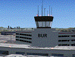
Welcome to Bob Hope Airport (KBUR) in Burbank California. KBUR is one of my favorite airports to fly into. Runway 8 is used for landing and if you are long and still in the air you better do a go-around. Some may remember when a Southwest 737 punched through the fence and ended up on N Hollywood Way. There is an EMAS there now. Hangar 71 is open and you can start from there by selecting "Parking 54" for your start. I added a couple of vehicle paths that cross both runways to keep the vehicle traffic off of the taxiways All runways and taxiways conform to the current FAA Airport Diagram (copy included). All the structures are new.
| Filename: | kbur_384155.zip |
| License: | Freeware, limited distribution |
| Added: | 10th June 2020, 19:26:25 |
| Downloads: | 1,108 |
| Author: | Brett Delana |
| Size: | 11.52 MB |
| Category: Flight Simulator X - Scenery | |
| 130 AI Ships and AI Ship Traffic |
|
Images related to this file:
File Description:
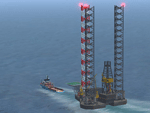
This package contains 130 new AI ships and AI ship traffic routes for the North Sea, the Norwegian coast and the sea around the Arabian Peninsula and a few routes for the Mediterranean Sea.
The new ship models include 40 ferries, 4 cruise ships, different types of fishing vessels, Platform Supply Vessels (PSV), Offshore Subsea Construction Vessels (OSCV), and shuttle tankers from off shore oil industry, a pirate mother ship, pirate attack boats, a Greenpeace ship, a heavy lift ship, a couple of frigates, a coast guard ship, container ships, bulk carriers, a number of small coasters, and much more. Around 40 ships have landable helicopter platforms - all marked with an H. Most ships will have simple animations and custom wake, smoke and light effects.
Ships visits among other places Le Havre, Plymouth, Jersey, Hull, Aberdeen, Oslo, Kristiansand, Stavanger, Bergen, Trondheim, Bodo, Narvik, Tromso, Hammerfest, Murmansk, Mallorca, Rome, Neaples, Heraklion, Port Said, Suez, Jeddah, Djibouti, Salalah, Muscat, Dubai, Abu Dhabi, Doha, Ras Tanura, Kuwait, Basra, Bandar Imam, Mogadishu, Karachi, and Mumbai.
In order to get full benefit of this package you must first download and install 63 AI Ships and AI Ship Traffic for Europe and South America, 75 AI Ships and AI Ship Traffic, and the corresponding patch. With that installed you will have a total of 268 ships on shipping routes across the globe.
Full credits to the many people who have contributed in this project can be found in the PDF manual.
| Filename: | 130_ai_ships_and_ai_ship_traffic.zip |
| License: | Freeware |
| Added: | 2nd March 2014, 12:37:04 |
| Downloads: | 11,471 |
| Author: | Henrik Nielsen |
| Size: | 56.26 MB |
| Category: Flight Simulator X - Scenery | |
| Crete Island, Version 2 |
|
Images related to this file:
File Description:
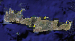
Crete is the bigger than the islands of the Greek archipelago and it is the south rampant of the Aegean sea. This scenery contains the following airports: LGIR, LGSA, LGOB, LGTL and 78 cities.
In this 2nd version I have used the mesh terrain of Yiannis Dermitzakis that offers a bigger realism to the costs. This has put under an obligation to reconstruct the entirety of the populations of the since costs they were located inside the sea. At the same time I have been able to redraw them populations with houses and real facilities that. I believe that I can offer a quite realistic scenery especially in the group of populations of the coast.
| Filename: | crete_264140.zip |
| License: | Freeware |
| Added: | 7th November 2009, 21:08:05 |
| Downloads: | 6,004 |
| Author: | Toni Agramont |
| Size: | 31.14 MB |
© 2001-2025 AVSIM Online
All Rights Reserved