
Where Flight Simulation Enthusiasts Gather from Around the World!
AVSIM Library - Search Results

| Category: Flight Simulator X - Scenery | |
| Centrair RJGG V3.0 complete |

|
Images related to this file:
File Description:
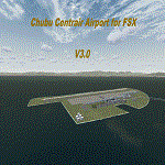
Chubu Centrair International Airport (IATA: NGO, ICAO: RJGG) is an airport on an artificial island in Ise Bay, 22 miles south of Nagoya in central Japan. Chubu is Japan's third off-shore airport, after Nagasaki Airport and Kansai International Airport, and is also the second airport built in Japan on a man-made island.
In this final version are added:
cars on parking garages
parking areas
static Air stairs
more realistic bagage loader
ANA logo on ground vehicles
Changed Skychefs catering trucks to NAC ( Nagoya Air Catering) catering trucks as in real life
benches on Chubu Airport's Sky Deck
lights on some static vehicles at night
fixed the readme desciption
| Filename: | centrair_rjgg_v3.0.zip |
| License: | Freeware |
| Added: | 20th November 2011, 00:13:22 |
| Downloads: | 7,981 |
| Author: | Morten Thomas van der Linden |
| Size: | 43.07 MB |
| Category: Flight Simulator X - Scenery | |
| Aerodromo de Tela - MHTE |
|
Images related to this file:
File Description:
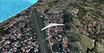
Tela Airport (Spanish: Aeropuerto de Tela) (IATA: TEA, ICAO: MHTE) is an airport serving Tela, a town in the Atlántida Department on the northern coast of Honduras. In 2009, plans were laid to lengthen the runway from 1,346 metres (4,416 ft) to 1,600 metres (5,200 ft) and possibly to construct a new terminal building. There are hills southeast of the runway. Northeast approach and departure are over the water. The La Mesa VOR-DME (Ident: LMS) is located 31.0 nautical miles (57.4 km) southwest of the airport. The Bonito VOR-DME (Ident: BTO)is located 35.4 nautical miles (65.6 km) east of the airport.
| Filename: | mhte_fsx.zip |
| License: | Freeware |
| Added: | 25th January 2021, 02:29:26 |
| Downloads: | 201 |
| Author: | Luis Flores |
| Size: | 88.04 MB |
| Category: Flight Simulator X - Scenery | |
| Robben Island Airstrip (AX78), Table Bay, South Africa |
|
Images related to this file:
File Description:
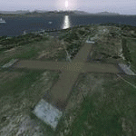
Robben Island is an island in Table Bay, some seven kilometers off the coast
of Cape Town, South Africa. The name is Dutch for "Seal Island". Robben Island
is roughly oval shaped with a disused gravel airstrip. It is of particular note
as it was here that former South African President and Nobel Laureate Nelson
Mandela and former South African President Kgalema Motlanthe, alongside many
other political prisoners were imprisoned. During the Second World War, the
island was fortified and guns were installed as part of the defences for Cape
Town. Please install fsxWorx01, fsxWorx02, and the updates before this
scenery.
| Filename: | fsxworx05upd1.zip |
| License: | Freeware, limited distribution |
| Added: | 18th November 2012, 09:56:56 |
| Downloads: | 3,462 |
| Author: | Hannes Steyn, Martin du Preez, Aeroworx |
| Size: | 18.99 MB |
| Category: Flight Simulator X - Scenery | |
| Savannah, Georgia - USA |
|
Images related to this file:
File Description:
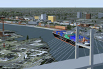
A large and detailed scenery of Savannah, Georgia. Includes downtown Savannah
and riverfront (with custom made buildings, hotels, convention center, gold domed
courthouse, and Talmadge Bridge), harbor with container terminal, AI ship traffic, and
a custom built streetcar to travel the downtown streets of Savannah.
KSAV Savannah/Hilton Head Intl Airport has a custom built terminal, Gulfstream factory, and Air National
Guard facility. KSVN Hunter AAF has a custom built US Coast Guard facility and AI helicopter
traffic. Coastal Tybee Island is represented with beachfront resorts and hotels, pier,
shopping district, and 2 functioning lighthouses. Great for the VFR flyer!
By Dan French.
| Filename: | savannahgeorgiausa_dlffsx.zip |
| License: | Freeware, limited distribution |
| Added: | 21st April 2014, 22:57:17 |
| Downloads: | 1,115 |
| Author: | Dan French |
| Size: | 11.54 MB |
| Category: Flight Simulator X - Scenery | |
| ValparaÃso Provincia, Litoral 2016. Chile. For FSX |
|
Images related to this file:
File Description:
Scenery of ValparaÃso Province from North (Quintero) to South (Laguna Verde valley). About 2.000 km2 intervention that brings up to fsx the current urban density, neighborhoods, forests and the most important iconic 3d objects you can recognize from a real VFR flight. This project uses FTX Vector as it main complement (only for the shapes of the coast). Also uses satellite background DAY/NIGHT, SPRING/ FALL / WINTER Photoscenery for Ritoque, Aconcagua, Concon, Embalse Los Aromos, Salinas, Borde Costero de Viña del Mar, Tranque La Luz, Peñuelas. Recomended to use (as an option) with my airport projects. SCVM, SCER, SCRD, SCSN, SCCV, SCIR, SCEL.
| Filename: | valparaiso_provincia_ov.zip |
| License: | Freeware |
| Added: | 4th November 2016, 04:59:42 |
| Downloads: | 1,077 |
| Author: | Orlando Veas |
| Size: | 180.37 MB |
| Category: Flight Simulator X - Scenery | |
| Detailed Terrain Features for Southern Africa, Update 9 |
|
Images related to this file:
File Description:
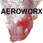
Scenery consist of Updated Terrain Vector data concerning Coastlines, rivers, dams, lakes, streams, roads, traffic, railroads, power lines and extrusion bridges for Southern African countries South of the Equator. A lot of work was done from the East Coast at Dar Es Salaam, west towards the Great Lakes in the Rift Valley like Lake Malawi, Lake Tanganyika, Lake Rukwa, Zambia and the Republic of the Congo and as far down as Lusaka and the Kafue swamps. Some work was also done around Robertson in the Cape and some around Ceres, With this scenery it is important to install the previous release of "fsxWorx01" and updates 1 to 8 before this file.
| Filename: | fsxworx01upd9.zip |
| License: | Freeware |
| Added: | 19th March 2014, 22:12:43 |
| Downloads: | 2,223 |
| Author: | Hannes Steyn, Aeroworx |
| Size: | 4.79 MB |
| Category: Flight Simulator X - Scenery | |
| Bastia Poretta Korsika |
|
File Description:
today, after almost three quarters of a year of construction, I present my new Airport Bastia Poretta in Corsica ....... I was there in 2019 and found nothing for the FSX other than Payware that I liked so building it myself was once announced again ............ the airport was tested by me on a different computer everything works perfectly, traffic works, AI traffic, road traffic and ILS approach works. So have fun in Bastia and go on a voyage of discovery with a small plane or helicopter so that you can see the many details fly from the airport along the coast to Bastia to the ferry port .........
| Filename: | lfkb-bastia-korsika.zip |
| License: | Freeware |
| Added: | 15th January 2020, 17:50:00 |
| Downloads: | 2,045 |
| Author: | Ewald Wagner |
| Size: | 70.37 MB |
| Category: Flight Simulator X - Scenery | |
| St Marys Municipal KOYM |
|
Images related to this file:
File Description:
FSX Scenery - St. Marys Municipal Airport (IATA: STQ, ICAO: KOYM, FAA LID: OYM) is a city-owned public-use airport three miles (5 km) southeast of the central business district of St. Marys, a city in Elk County, Pennsylvania, United States..[1] This general aviation airport is located off South Michael Road in St. Marys. St. Marys Municipal Airport covers an area of 283 acres (115 ha) and contains one runway designated 10/28 with a 4,300 x 75 ft (1,311 x 23 m) asphalt pavement. For the 12-month period ending October 31, 2007, the airport had 6,730 aircraft operations, an average of 18 per day: 85% general aviation, 15% air taxi and
| Filename: | st_marys_municipal_koym_fsx.zip |
| License: | Freeware, limited distribution |
| Added: | 2nd November 2010, 01:35:54 |
| Downloads: | 529 |
| Author: | John B. Loney, Jr. |
| Size: | 1.06 MB |
| Category: Flight Simulator X - Scenery | |
| RCMQ Ching Chuan Kang Air Base, Taiwan |
|
File Description:
This is an improvement of the default RCMQ Ching Chuan Kang Air Base, a dual-use airport in Central Taiwan that was built by the US in 1960s to serve as a divert base for B-52 bombers during Vietnam War. It is now the home of ROCAF 427th Tactical Fighter Wing flying F-CK-1 Ching-Kuo fighters. It is also served by airlines with flights to domestic destinations as well as Hongkong, China, and Vietnam. Satellite imagery available online were used to reposition taxiways, add and resize aprons, and add civilian gates and military aircraft parking. Prominent buildings were represented using stock library objects. Created using Airport Design Editor 1.39b by Mike Huang.
| Filename: | mh_rcmq.zip |
| License: | Freeware |
| Added: | 7th February 2009, 19:31:44 |
| Downloads: | 2,677 |
| Author: | Mike Huang |
| Size: | 522 KB |
| Category: Flight Simulator X - Scenery | |
| Greater Kankakee KIKK |
|
Images related to this file:
File Description:
FSX Scenery - Greater Kankakee Airport (IATA: IKK, ICAO: KIKK, FAA LID: IKK) is a public airport located three miles (5 km) south of the central business district of Kankakee, in Kankakee County, Illinois, United States. The airport was opened in 1962 and continues to operate as a general aviation facility serving the Kankakee area and South Chicago. It is 60 miles (97 km) south of Chicago and 75 miles (121 km) north of Champaign, Illinois. It is the largest Airport between the Chicago Midway Airport and the Champaign Airport. Greater Kankakee is a general aviation airport, consisting of mostly private aircraft with a mix of corporate and business aircraft usage. Created by John B Loney Jr.
| Filename: | greater_kankakee_kikk_fsx.zip |
| License: | Freeware, limited distribution |
| Added: | 20th March 2012, 01:36:22 |
| Downloads: | 635 |
| Author: | John B. Loney, Jr. |
| Size: | 4.09 MB |
© 2001-2025 AVSIM Online
All Rights Reserved