
Where Flight Simulation Enthusiasts Gather from Around the World!
AVSIM Library - Search Results

| Category: Flight Simulator X - Scenery | |
| Project OTHH - Hamad International Airport (New Doha), Qatar |

|
Images related to this file:
File Description:
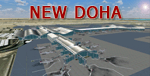
Hamad International Airport (New Doha). Ground surrounding is photoreal captured with FS Earth Tiles. It includes GMAX Main terminal, Concourses A, B, C, Tower, biggest hangars. All additional objects have been placed with Instant Scenery 2 from (Flight 1). Airport ground textures are made with SBuilderX & FS Earth Tiles. Dedicated AFCAD is set to "OTBD" ICAO to use actual AI Flightplans. Include official OTHH ATC frequencies, rwy lightning, runway settings, ILS, and approaches and many other surprises... Visit my web site www.christophebouville.com
| Filename: | Project_OTHH__Hamad_International_Airport_New_Doha.zip |
| License: | Freeware, limited distribution |
| Added: | 5th October 2013, 18:28:56 |
| Downloads: | 42,621 |
| Author: | Christophe Bouville |
| Size: | 54.41 MB |
| Category: Flight Simulator X - Scenery | |
| KDAY - Dayton International Airport - Vandalia, Ohio |
|
Images related to this file:
File Description:
The Dayton International Airport, located 11 miles north of Dayton in Vandalia, Ohio, is a medium sized commercial airport serving nearly three million passengers annually with daily nonstop service to about twenty destinations.
This scenery includes a custom terminal building, moving jetways, and an AFX file with accurate parking assignments. Also modeled is the new air traffic control tower, terminal parking garage, the Fed Ex building, the PSA Airlines headquarters and maintenance hanger, the former Emery Worldwide cargo sort facility, the airport hotel, and hangers for fixed base operators Stevens Aviation and Wright Brothers Aero.
More than a thousand objects have been added to enhance detail around the airport using Flight 1's excellent instant scenery program. AI Traffic has been tested to ensure efficient flow. The landclass file has also been adjusted to better reflect the real airport.
| Filename: | KDAY__Dayton_International_Airport__Vandalia_Ohio.zip |
| License: | Freeware |
| Added: | 2nd December 2012, 22:32:37 |
| Downloads: | 1,567 |
| Author: | Matt Parr |
| Size: | 5.78 MB |
| Category: Flight Simulator X - Scenery | |
| Calgary Intl Airport (CYYC) Alberta, Canada with new Terminal |
|
Images related to this file:
File Description:
This scenery is for CYYC with two optional files and made only for FSX: one version with the Crosswind runways operating where all 4 runways will be used for takeoff and landing and one version as the default airport runway operation: assigned parking as per their website with extra parking, the new international terminal added, concourse D and Concourse E, a new midfield control tower, Sunwest Aviation has now moved to its new location with its buildings and hangar also included, i have also coded the parking spots for Sunwest for those using their flight plans, taxiways and taxi signs updated to the latest charts, lighted helipad, extra fuel trucks, support vehicle roads rebuilt and many other scenery improvements and objects added, airport views are from the roof of the new control tower (when in tower view), please view the readme before installation.
| Filename: | Calgary_Intl_Airport_CYYC_Alberta_Canada_with_new_.zip |
| License: | Freeware, limited distribution |
| Added: | 12th November 2016, 18:56:35 |
| Downloads: | 42,364 |
| Author: | Ray Smith |
| Size: | 2.7 MB |
| Category: Flight Simulator X - Scenery | |
| Boundary Bay Airport - CZBB |
|
File Description:
Located North and West of the community of Boundary Bay, so named because it is situated on the border between Canada and the United States. The airport is home to a large number of general aviation operations, as well as many flight training schools and flying clubs that provide aircraft rentals, safety seminars and social events. I have endeavored to represent the photos and satellite images through the use of FSX Deluxe library objects. VANCOUVER PLUS is required for this scenery to work correctly.
| Filename: | Boundary_Bay_Airport__CZBB.zip |
| License: | Freeware, limited distribution |
| Added: | 15th April 2009, 06:07:00 |
| Downloads: | 859 |
| Author: | Will Jones |
| Size: | 195.9 KB |
| Category: Flight Simulator X - Scenery | |
| Cross Country VFR Airfields |
|
File Description:
Here are 23 airports spanning the United States from Provincetown, Massachusetts to Oceanside, California...Designed for the VFR general aviation pilot...These are not "photo-real", just fun to fly into and see something other than blank fields when you arrive...They are built from FSX generic objects so no additional libraries or textures are needed...Please see the readme file for complete listing of airports and other info...I hope these fields will encourage the general aviation FSX pilot to try that cross country flight!
| Filename: | Cross_Country_VFR_Airfields.zip |
| License: | Freeware |
| Added: | 24th September 2008, 02:44:16 |
| Downloads: | 1,708 |
| Author: | Steve Ziegler |
| Size: | 107.44 KB |
| Category: Flight Simulator X - Scenery | |
| LMML-JVX |
|
Images related to this file:
File Description:
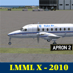
LMML Luqa Malta Airport reworked.
Landing on a flight to Luqa I found out the Runway numbers and directions [degr.] of the scenery was wrong.
Not only that, Luqa is a fairly big airport, but this scenery is a bit barren as well.
Therefore: Luqa with corrected runways 31-13 plus slightly corrected heading 313 degree. plus a bit.
Runway 23-05 corrected by name not by direction.
Added the usual fun stuff such as boats on the Mediterranean Sea, seagulls, crows, sinage, buildings etc.
| Filename: | LMMLJVX.zip |
| License: | Freeware, limited distribution |
| Added: | 26th May 2010, 19:02:30 |
| Downloads: | 6,785 |
| Author: | Joost Visser |
| Size: | 327.84 KB |
| Category: Flight Simulator X - Scenery | |
| KCLL Easterwood Airport College Station Texas USA |
|
Images related to this file:
File Description:
Easterwood College Station Texas Airport for FSX. Several improvements have been made to the default airport. The default terminal building has been replaced with one created in FSDS; aircraft gates have been correctly coded using Airport Design Editor 1.70.6042; a new airport vehicle network has been built to prevent airport vehicles from entering the taxiways; extra fuel trucks have been added throughout the airport; the tower view has been changed to display from the roof of the control tower; all taxiway signs are correctly placed and all taxiway designators are correctly named; there is the option to open all runways to AI traffic; optionally, a set of GA flight plans is included using all default FSX aircraft to liven up the GA area; and Jim Dhaenen's excellent ramp lights are also included. Please refer to the README.txt file to insure proper installation of all files.
| Filename: | KCLL_Easterwood_Airport_College_Station_Texas_USA.zip |
| License: | Freeware, limited distribution |
| Added: | 25th November 2017, 16:08:22 |
| Downloads: | 442 |
| Author: | Patrick Finch |
| Size: | 1.09 MB |
| Category: Flight Simulator X - Scenery | |
| HALA - Hawassa Intl. - Hawassa, Ethiopia |
|
Images related to this file:
File Description:
This project adds the booming city of Hawassa, Ethiopia, creates the new international airport (HALA), moves (and rebuilds) the downtown airport (recoded to HALX), and includes AI flight plans for the Ethiopian Airlines service that began April 2016. Tested in both the default FSX: Acceleration and with FTX Global/Vector, accurate coastlines, lakes, road data, and SRTMGL1 (30m) mesh, as well as corrected landclass are provided based on the latest available satellite imagery. The Hawassa International Airport was created using information from the current satellite footprint and the promotional video from Ethiopian Airports Enterprise (EAE). Although there is still very little published data on the airport, it is fully functional.
Updates were created or rebuilt in a manner which carefully aligns airport data with current satellite imagery. Scenery was created using Airport Design Editor X v1.70.6042, SBuilderX 3.13, and the FSX Object Placement Tool. Scenery objects were added and modified from stock FSX scenery to resemble as closely as possible the actual airports. The FSX apron lights included are from the set created by Jim Dhaenens. Thanks to Ron Blehm for bringing this part of the world to my attention.
| Filename: | HALA__Hawassa_Intl___Hawassa_Ethiopia.zip |
| License: | Freeware |
| Added: | 20th July 2016, 09:06:40 |
| Downloads: | 1,016 |
| Author: | Carlyle Sharpe |
| Size: | 10.41 MB |
| Category: Flight Simulator X - Scenery | |
| Bhutan Airports and Paro Valley |
|
Images related to this file:
File Description:
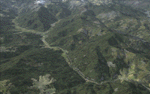
This project adds and updates all of the airports of Bhutan. Bathpalathang (VQBT) and Gelephu (VQGP) are added, Yongphulla (VQ10) is updated and recoded as VQTY, and Paro (VQPR) is fully updated to reflect current satellite imagery. These are all fully functioning AI airports as well. Special attention was given to the entire Paro Valley, and numerous road/river vectors were updated around Gelephu. Accurate coastlines, lakes, road and river data, as well as corrected landclass are provided based on the latest available satellite imagery. They are optimized to fit seamlessly with FTX Vector's roads/water, but they should be fully functional in all FSX configurations.
GA-encoded flight plans for the Buddha Air/Kathmandu charter are provided to enhance service to Paro. NASA SRTM Global 3 arc second terrain mesh is also included for all of Bhutan. Updates were created or rebuilt in a manner which carefully aligned airport data with current satellite imagery, when available. Scenery was created using Airport Design Editor X v1.61.5298, SBuilderX 3.13, and the FSX Object Placement Tool. Scenery objects were added and modified from stock FSX scenery to resemble as closely as possible the actual airports.
| Filename: | Bhutan_Airports_and_Paro_Valley.zip |
| License: | Freeware |
| Added: | 19th January 2015, 06:09:17 |
| Downloads: | 11,410 |
| Author: | Carlyle Sharpe |
| Size: | 21.4 MB |
| Category: Flight Simulator X - Scenery | |
| LYPG Podgorica Airport, Montenegro |
|
File Description:
Podgorica Airport (IATA: TGD, ICAO: LYPG) is an international airport located 11 km (6.8 mi) south of Podgorica, Montenegro. It is the main hub for Montenegro Airlines.
It is one of two public airports in Montenegro, the other being Tivat Airport. Both are operated by the state-owned company Airports of Montenegro. The airport is sometimes called Golubovci Airport by the locals, as the town of
Golubovci is in close proximity. Airports Council International awarded Podgorica the best airport under 1 million passengers in 2007.
The IATA code of the airport is still TGD because Podgorica was named Titograd (after Josip Broz Tito) from 1946 to 1992, during which time the airport opened.
The airport handles domestic flights within Montenegro as well as international flights. As Montenegro's two main airports are merely 80 km apart, there are no regular passenger domestic flights. Domestic flights have been reduced to
charter flights and general aviation, and all scheduled traffic is international.
There are daily scheduled flights to various European destinations. During the summer season, there are many charter flights and air connections to various major cities in the world. The flight to Belgrade airport has traditionally
accounted for majority of the traffic at the airport, but the percentage is decreasing.
VIP and taxi airlines Vektra Aviation, Di Air and OKI Air are based at the airport. Serbian VIP airlines Air Pink and Prince Aviation also use the airport.
Podgorica Airport served 538,477 passengers in 2008. However, due to global economic downturn, passenger numbers declined to 450,504 in 2009. In 2010, strong growth was recorded, so numbers passed the 600,000 mark.
Thanks to Serbia And Montenegro Virtual Area Control Center for the airport charts.
This file has the right coordinates, with the apron and characteristics of the airport, airport vehicles and buildings, also it is set to the correct altitude of 126 feet or 38 meters.
| Filename: | LYPG_Podgorica_Airport_Montenegro.zip |
| License: | Freeware |
| Added: | 29th October 2012, 21:41:37 |
| Downloads: | 4,647 |
| Author: | Anwar Gonzalez |
| Size: | 10.52 MB |
© 2001-2026 AVSIM Online
All Rights Reserved
Privacy Policy |