
Where Flight Simulation Enthusiasts Gather from Around the World!
AVSIM Library - Search Results

| Category: Flight Simulator X - Scenery | |
| MKBS - Boscobel Aerodrome - Ocho Rios, Jamaica |

|
File Description:
This is NOT a representation of the Ian Fleming International Airport. This is the Boscobel Aerodrome before the renovation which was much more challenging and busier as far as air traffic.
Neither FSX nor any third party gave Jamaican domestic airports enough attention to detail, so I messed around with an afcad file for MKBS. Also included is a bgl file for Ocho Rios, an important tourist town served by MKBS, that FSX basically forgets about. Though not necessary for this scenery to work correctly, I recommend Installing SceneryTech North America 1.4 as this scenery blends in nicely with it as it changes Jamaican vegetation completely.
This supersedes a file by Martin Erinin for FS2004. A pack of all the domestic airports in Jamaica.
| Filename: | MKBS__Boscobel_Aerodrome__Ocho_Rios_Jamaica.zip |
| License: | Freeware |
| Added: | 24th April 2014, 12:00:34 |
| Downloads: | 655 |
| Author: | Chris Zoepound / Martin Erinin |
| Size: | 7.44 MB |
| Category: Flight Simulator X - Scenery | |
| LGLS - Lousoi Airfield **Fictional** |
|
Images related to this file:
File Description:
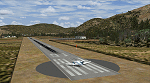
An imaginary airfield in north central Peloponnese Greece named after the elevated mountain plain where it would be situated. LGLS Lousoi airfield has a 1,000m runway at elevation of 3,186ft surrounded by mountains.
The aiport is equiped with NDB, ILS DME, PAPIs and night lighting for instrument approaches; approach chart included.
As bonus two imaginary helipads LGKK Kleitoria and LGPP Planitero are added in the nearby two villages.
All are infrastructure I wish they existed in the area since I drive there often for vacations in Planitero and always wondered how it would be if I could fly there. Planitero sits at the south footings of Chelmos mountain, the highest peak in the area. No AI traffic plans included.
| Filename: | LGLS__Lousoi_Airfield_Fictional.zip |
| License: | Freeware, limited distribution |
| Added: | 15th April 2015, 01:07:43 |
| Downloads: | 138 |
| Author: | Kyprianos Biris |
| Size: | 1.87 MB |
| Category: Flight Simulator X - AI Flight Plans | |
| Sky Regional - Summer 2018 |
|
Images related to this file:
File Description:

Current flight plan of Sky Regional for summer 2018.
Sky Regional Airlines is an airline whose corporate headquarters is on the property of Toronto Pearson International Airport, Mississauga, Ontario, Canada. Linked with Skyservice Business Aviation, it began operation under the Air Canada Express brand on May 1, 2011. The airline began offering daily flights between Toronto Island and Montréal–Pierre Elliott Trudeau International Airport.
Sky Regional introduced a fleet of Embraer 175 jets in March 2013 to serve US destinations such as New York, Newark, Boston, Philadelphia, Chicago, and Dallas/Fort Worth.
Between October and December 2015 the fleet of 20 was expanded to 25 after obtaining 5 additional Embraer 175 previously operated by Azul Brazilian Airlines. These aircraft were put into service in April 2016 allowing the airline to add routes to more US destination such as Denver International Airport, and Hartsfield-Jackson Atlanta International Airport.
| Filename: | Sky_Regional__Summer_2018.zip |
| License: | Freeware |
| Added: | 12th August 2018, 19:31:54 |
| Downloads: | 262 |
| Author: | Frank Drebing |
| Size: | 26.07 KB |
| Category: Flight Simulator X - Scenery | |
| CYQQ (2010) Version 2 for FS9, FSX and Prepar3D |
|
Images related to this file:
File Description:
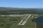
CYQQ (2010) portrays Canadian Forces Base Comox (Vancouver Island, British Columbia, Canada) (CYQQ), the Comox Valley Air Terminal and surrounding area. It is fully compatible with Ultimate Terrain Canada/Alaska for FS2004, Ultimate Terrain X - Canada for FSX and ORBX's FTX NA Blue. CYQQ (2010) includes over 100 "hand-crafted" buildings and other structures and 10 different vintage aircraft on static display, as well as aircraft and traffic files for a realistic AI scenario that causes a variety of military aircraft that come and go. (Use BC Regional AI - also available from this file library - for scheduled traffic.) Civilian AI is now routed so as not to transit military aprons.
Aside from the new approach lighting, generally, this new version is visually identical to its predecessor - even though quite different internally. As well, to the extent possible, it is compatible with Prepar3Dv2.
| Filename: | CYQQ_2010_Version_2_for_FS9_FSX_and_Prepar3D.zip |
| License: | Freeware, limited distribution |
| Added: | 20th June 2014, 11:39:47 |
| Downloads: | 11,035 |
| Author: | Don Grovestine |
| Size: | 33.19 MB |
| Category: Flight Simulator X - Scenery | |
| FIMP - Sir Seewoosagur Ramgoolam Intl - Mauritius *New Terminal & Airport Layout* |
|
Images related to this file:
File Description:

This scenery adds the new terminal and taxiways, and rebuilds the aprons and runway to provide a fully functioning AI traffic extension for runway 14. The airport is assigned a mean elevation, allowing it to blend naturally with the surrounding terrain, and landclass is provided for the entire island. This scenery is most effective when used in combination with "mauritius_fsx.zip" by Max Kraus. This scenery is optimized to fit seamlessly with FTX Global/Vector and should also be fully functional in all FSX configurations. The airport is updated to reflect current satellite imagery and positioning. Scenery was created using Airport Design Editor X v1.61.5298, SBuilderX 3.13, and the FSX Object Placement Tool. Scenery objects were added and modified from stock FSX scenery to resemble as closely as possible the actual airport. The FSX apron lights included are from the set created by Jim Dhaenens.
| Filename: | FIMP__Sir_Seewoosagur_Ramgoolam_Intl__Mauritius_Ne.zip |
| License: | Freeware |
| Added: | 10th July 2015, 16:16:40 |
| Downloads: | 8,786 |
| Author: | Carlyle Sharpe |
| Size: | 5.06 MB |
| Category: Flight Simulator X - AFCAD Files | |
| KEGE - Eagle County Regional - Eagle, Colorado USA * FIX * |
|
File Description: KEGE - Eagle County Rgnl - Eagle, CO, USA version 1.1 by Jason Boche
This is an update of the default FSX KEGE airport.
Enhancements include:
-Runway 7/25 lengthened to current, displaced threshold and markings added
-Blast pads added
-Updated taxiways to current
-PAPI lights moved to right/north side of runway 25
-Updated LOC frequency for runway 25 to 109.75
-Moved and added additional LOC antennea to the west end of runway 7
-Tower moved and model replaced
-Realistic terminal parking spots 1-10
-Asphalt and concrete aprons added/updated, ground lighting updated
-Asphalt, concrete, and gravel roads added
-Many bulidings updated
-All applicable runway signs updated
-Added airport, civilian, and construction vehicles
-Airport perimeter fencing updated
-Runway demolition fencing added
-National Guard helipads added
-GA refueling moved to the north end of the field
Please provide any feedback and suggestions to me at the email address listed
in the readme.txt. Thank you.
Acknowledgements:
Airport Design Editor (ADE -Freeware) - Jon Masterson.........http://www.scruffyduck.org.uk/
This also has a download centre for many other ADE files.
Please visit here for more information...........http://www.airportdesigneditor.co.uk
Any questions relating to ADE can be answered at www.fsdeveloper.com/forum......look
for Airport Design Editor author
Ray Smith for providing so many freeware airports and airport updates which
inspired me to give ADE a try.
Jason Boche
| Filename: | KEGE__Eagle_County_Regional__Eagle_Colorado_USA__F.zip |
| License: | Freeware |
| Added: | 30th November 2013, 10:42:48 |
| Downloads: | 1,476 |
| Author: | Jason Boche |
| Size: | 373.01 KB |
| Category: Flight Simulator X - Scenery | |
| RAF Spanhoe - Northamptonshire, England |
|
File Description:
RAF Spanhoe (also known as Harringworth or Wakerley) (ICAO X3SE) is a former World War II airfield in Northamptonshire, England. The airfield is located approximately 4 miles (6.4 km) east of Uppingham; about 80 miles (130 km) north-northwest of London
Opened in 1943, it was used by both the Royal Air Force and United States Army Air Forces. During the war it was used primarily as a transport airfield,
it was closed in late 1945 after the WWII.
Today, much of the airfield has been returned to agriculture, however; the remains of some of the runways can be seen from the air and a part of the old peri track is used by various privately owned light aircraft which are housed at the old airfield. Source: Wikipedia
| Filename: | RAF_Spanhoe__Northamptonshire_England.zip |
| License: | Freeware |
| Added: | 7th March 2016, 21:40:28 |
| Downloads: | 222 |
| Author: | Terry Boissel |
| Size: | 2.36 MB |
| Category: Flight Simulator X - Scenery | |
| RAF Kelstern - Lincolnshire, England |
|
File Description:
RAF Kelstern is a former Royal Air Force station located 3.6 miles (5.8 km) south east of Binbrook, Lincolnshire and 4.9 miles (7.9 km) north west of Louth,
Opening for business in late September of 1943 the first Sqn to be based at the station was actually formed there (No 625) and became operational in mid October 1943 and was undertaking their first operational tour with 9 Lancasters bombing Hanover afew nights later. As with many RAF Stations, of the era, RAF Kelstern was placed on care and maintenance and finally closed in August 1946. The Station was sold off to various farmers during the 60s with very little left to show of an active airfield. Third party add-on's will be required. See the readme.txt file for details.
| Filename: | RAF_Kelstern__Lincolnshire_England.zip |
| License: | Freeware |
| Added: | 31st October 2015, 12:25:45 |
| Downloads: | 151 |
| Author: | Terry Boissel |
| Size: | 9.63 KB |
| Category: Flight Simulator X - Scenery | |
| RAF Lindholme (1940s) |
|
File Description:
RAF Lindholme is located 3.9 miles (6.3 km) south of Thorne and 6.9 miles (11.1 km) north east of Doncaster and was initially called RAF Hatfield Woodhouse and started life as an
expansion scheme aerodrome built on the wide expanse of Hatfield moors, some five miles east of Doncaster. The site, to the east of the A614 Thorne to Bawtry road, was a mile
south of the small village of Hatfield Woodhouse, the name first selected for the new station. Work began in the spring of 1938 taking in approximately 250 acres (1.0 km2) of
pasture for the airfield itself and a further 150 for the camp and support facilities.
RAF lindholme had a long a varied career, details of which cam be found at:- https://en.wikipedia.org/wiki/RAF_Lindholme
Source:Wikipedia
| Filename: | RAF_Lindholme_1940s.zip |
| License: | Freeware |
| Added: | 4th March 2017, 19:57:23 |
| Downloads: | 87 |
| Author: | Terry Boissel |
| Size: | 1.24 MB |
| Category: Flight Simulator X - Aircraft Repaints, Textures and Modifications | |
| Republic Airlines '1985' Boeing 727-200 |
|
Images related to this file:
File Description:

Republic Airlines was formed on July 1 1979 through the merger of Southern Airlines and North Central Airlines, both major regional carriers. In 1980 Republic absorbed Hughes Airwest, also a major regional carrier. By 1984 republic was the 5th largest airline in the USA (and 7th largest in the world) with over 1,300 daily flights. They mainly flew to points in the USA, Canada, Mexico, and the Cayman Islands. Northwest Airlines was unhappy with the upstart competitor, and in January 1986 made a huge $884 million bid for Republic. Stephen Wolf, Republic's president & CEO, accepted the Northwest offer. Thus ended Republic's short life. Textures are 32 bit. This repaint is in Republic's mid 80s "Mary Tyler Moore" scheme. It was tested on P3D v3, and should work on FSX & FSX-SE.
| Filename: | Republic_Airlines_1985_Boeing_727200.zip |
| License: | Freeware |
| Added: | 12th April 2018, 00:26:39 |
| Downloads: | 62 |
| Author: | Ted Giana |
| Size: | 10.73 MB |
© 2001-2026 AVSIM Online
All Rights Reserved
Privacy Policy |