
Where Flight Simulation Enthusiasts Gather from Around the World!
AVSIM Library - Search Results

| Category: Flight Simulator X - Scenery | |
| Vancouver Extras |

|
Images related to this file:
File Description:
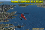
Vancouver Extras. A lot of new objects like high rise helipads (an aerial map showing their locations), more helipads on docks at the waters edge, many ships in port and out at sea including a carrier with escorts. The carrier has 3 Jayhawks and 1 RAC Bell 412 on it. Cruise ships, cargo ships and a super tanker.
Most of the objects are north of the city on the shoreline and the addition of several marinas with docks/boats. Also an area with cranes, vehicles and a shipping container yard with lots of other stuff.
Add the download "Indian Arm Float Base.zip" and really spruce up the area.
Designed to enhance your FSX world and make your flights more interesting.
Please enjoy! savageagle
| Filename: | Vancouver_Extras.zip |
| License: | Freeware |
| Added: | 24th July 2010, 09:06:13 |
| Downloads: | 3,618 |
| Author: | Tim Durham |
| Size: | 8.55 MB |
| Category: Flight Simulator X - Aircraft Repaints, Textures and Modifications | |
| Cessna C172M (SX-AWD) |
|
Images related to this file:
File Description:

This is a representation of SX-AWD, of the Athens Aeroclub based in Tatoi LGTT, north of Athens. It is used by all club members holding a PPL and is the next step of graduation by all pilots who have completed their basic training in the trusty smaller brother the Cessna 152 II. It is also available for pleasure flights and initiation flights for non members.
The actual plane is an older "M" model with carburetor equipped engine so there are several model differences from the "R" represented by A2A including antennae, landing lights on the nose and very different cockpit with no headrests and different door interior and instrument panel. The actual one is also equipped with an ASI in mph instead of knots.
| Filename: | Cessna_C172M_SXAWD.zip |
| License: | Freeware |
| Added: | 13th September 2013, 23:01:42 |
| Downloads: | 322 |
| Author: | Vassilios Dimoulas |
| Size: | 20.05 MB |
| Category: Flight Simulator X - Scenery | |
| MKBS - Boscobel Aerodrome - Ocho Rios, Jamaica |
|
File Description:
This is NOT a representation of the Ian Fleming International Airport. This is the Boscobel Aerodrome before the renovation which was much more challenging and busier as far as air traffic.
Neither FSX nor any third party gave Jamaican domestic airports enough attention to detail, so I messed around with an afcad file for MKBS. Also included is a bgl file for Ocho Rios, an important tourist town served by MKBS, that FSX basically forgets about. Though not necessary for this scenery to work correctly, I recommend Installing SceneryTech North America 1.4 as this scenery blends in nicely with it as it changes Jamaican vegetation completely.
This supersedes a file by Martin Erinin for FS2004. A pack of all the domestic airports in Jamaica.
| Filename: | MKBS__Boscobel_Aerodrome__Ocho_Rios_Jamaica.zip |
| License: | Freeware |
| Added: | 24th April 2014, 12:00:34 |
| Downloads: | 655 |
| Author: | Chris Zoepound / Martin Erinin |
| Size: | 7.44 MB |
| Category: Flight Simulator X - Scenery | |
| LGLS - Lousoi Airfield **Fictional** |
|
Images related to this file:
File Description:
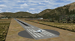
An imaginary airfield in north central Peloponnese Greece named after the elevated mountain plain where it would be situated. LGLS Lousoi airfield has a 1,000m runway at elevation of 3,186ft surrounded by mountains.
The aiport is equiped with NDB, ILS DME, PAPIs and night lighting for instrument approaches; approach chart included.
As bonus two imaginary helipads LGKK Kleitoria and LGPP Planitero are added in the nearby two villages.
All are infrastructure I wish they existed in the area since I drive there often for vacations in Planitero and always wondered how it would be if I could fly there. Planitero sits at the south footings of Chelmos mountain, the highest peak in the area. No AI traffic plans included.
| Filename: | LGLS__Lousoi_Airfield_Fictional.zip |
| License: | Freeware, limited distribution |
| Added: | 15th April 2015, 01:07:43 |
| Downloads: | 138 |
| Author: | Kyprianos Biris |
| Size: | 1.87 MB |
| Category: Flight Simulator X - Aircraft Repaints, Textures and Modifications | |
| "Real World Livery" Embraer EMB-505 Phenom 300 (N900HT) |
|
Images related to this file:
File Description:

This is a very close approximation of a real world Embraer Phenom 300. The home base of N900HT is not known for sure, but is occasionally seen coming and going from Big Bear City airport in Southern California. Daytona Beach, FL is also frequented by this one. Big Bear City is one of those high altitude airports in the mountains West of twentynine Palms and East of LAX and North of Palm Springs. N900HT was delivered in September, 2011 and was featured in a sales video by one of the active private jet dealers in sunny Southern California. You will need to own a copy of the Carenado EMB-505 Phenom 300 for FSX, P3D or FSX:Steam to use this repaint. Enjoy.
| Filename: | Real_World_Livery_Embraer_EMB505_Phenom_300_N900HT.zip |
| License: | Freeware |
| Added: | 29th October 2015, 23:48:38 |
| Downloads: | 1,312 |
| Author: | Ray Marshall |
| Size: | 27.9 MB |
| Category: Flight Simulator X - Scenery | |
| RAF Upper Heyford "1940s" - Oxfordshire, England |
|
File Description:
RAF Upper Heyford was a Royal Air Force station located 5 miles (8 km) north-west of Bicester near the village of Upper Heyford, Oxfordshire, England.
| Filename: | RAF_Upper_Heyford_1940s__Oxfordshire_England.zip |
| License: | Freeware |
| Added: | 21st May 2016, 20:33:23 |
| Downloads: | 156 |
| Author: | Terry Boissel |
| Size: | 1.27 MB |
| Category: Flight Simulator X - Scenery | |
| RAF Atcham |
|
File Description:
Royal Air Force Atcham or more simply RAF Atcham is a former Royal Air Force station located 5.0 miles (8.0 km) east of Shrewsbury, Shropshire, England, on the north eastern boundary of Attingham Park.
Initially built for RAF Fighter Command, during the Second World War its primary use was by the United States Army Air Forces (USAAF) Eighth Air Force. It was mainly the home of the 495th Fighter Training Group, where pilots were trained to fly Republic P-47 Thunderbolts although a few also were trained to fly twin-engined Lockheed P-38 Lightnings for both Eighth and Ninth Air Force units. Atcham continued to see use as a training base until it was returned to the RAF in March 1945.
Source:Wikipedia
| Filename: | RAF_Atcham.zip |
| License: | Freeware |
| Added: | 7th February 2017, 21:22:53 |
| Downloads: | 139 |
| Author: | Terry Boissel |
| Size: | 82.57 MB |
| Category: Flight Simulator X - Scenery | |
| Lake Kipawa - Quebec bush scenery |
|
File Description:
This scenery is fictitious and created for the pleasure of all. All the objects are already included in FSX and no other library was used. Seaplane base Kipawa is located on the North side of the lake, and this place is meant to be a site of free time for small boats. It can also be a refueling place for seaplanes. Lake Kipawa is situated at the far South West coast of Quebec, in the region of Abitibi-Temiscamingue. Must have before installing the Aerovirtuel bush flying sceneries:
1-Quebec Elevation 38m (LOD10) Gilles Gauthier sur http://avsim.com/ 5 files.
2-Quebec Scenery - Lakes and Rivers (1/5) http://avsim.com/ 5 files and one fix
3-Quebec Scenery - Addition of Roads http://avsim.com/
| Filename: | Lake_Kipawa__Quebec_bush_scenery.zip |
| License: | Freeware, limited distribution |
| Added: | 10th November 2007, 22:15:04 |
| Downloads: | 838 |
| Author: | Denis Dupuis |
| Size: | 1.01 MB |
| Category: Flight Simulator X - Scenery | |
| Lake Magpie - Quebec bush scenery |
|
File Description:
This scenery is fictitious and created for the pleasure of all. All the objects are already included in FSX and no other library was used. This scenery simulates the Headquarters of Aérovirtuel bush flying section for the region of Duplessis, Qc. The Lake Magpie is about 100Km North West of Havre St-Pierre. This place is hilly but perfect for a quick response for emergencies in the East part of Québec. This base has all services, oil gaz included.Must have before installing the Aerovirtuel bush flying sceneries:
1-Quebec Elevation 38m (LOD10) Gilles Gauthier sur http://avsim.com/ 5 files.
2-Quebec Scenery - Lakes and Rivers (1/5) http://avsim.com/ 5 files and one fix
3-Quebec Scenery - Addition of Roads http://avsim.com/
| Filename: | Lake_Magpie__Quebec_bush_scenery.zip |
| License: | Freeware, limited distribution |
| Added: | 10th November 2007, 22:15:41 |
| Downloads: | 846 |
| Author: | Denis Dupuis |
| Size: | 416.57 KB |
| Category: Flight Simulator X - Miscellaneous Files | |
| European RVSM v1.1 |
|
File Description:
I quite often forget which the correct Reduced Vertical Separation Minima (RVSM) flight levels for Europe are. To complicate things further some countries apply a North-South instead of the standard East-West altitude designation.
To avoid being a potential conflict when flying online on Vatsim or IVAO, I've made the following graphic as a quick reference for my flight levels in Europe. It is in an A4 portrait format to allow easy printing.
I'd like to thank the following people for replying to my posts and helping me to get the correct information regarding European RVSM: CaptainCernick, Marten Weber, Mike T, Tom Pieters and Richard Ronhovde.
Version 1.1: Updated the image to make it clear that RVSM applies from FL290 up to FL410.
| Filename: | European_RVSM_v11.zip |
| License: | Freeware |
| Added: | 21st May 2008, 16:08:32 |
| Downloads: | 1,031 |
| Author: | Gerhard Brouwer |
| Size: | 1.02 MB |


© 2001-2026 AVSIM Online
All Rights Reserved
Privacy Policy |