
Where Flight Simulation Enthusiasts Gather from Around the World!
AVSIM Library - Search Results

| Category: Flight Simulator X - Scenery | |
| GABS Bamako Senou International Airport |

|
File Description:
Bamako Senou International Airport (IATA: BKO, ICAO: GABS) is Malis main airport approximately 15 km south of downtown Bamako, the capital of Mali in West Africa. It is managed by Aeroports du Mali (ADM). Its operations are overseen
by the Malian Ministry of Equipment and Transports. Senou Airport was opened to traffic in 1974. The airport was upgraded between 2007 and 2012 in a 181 million US dollar project funded by the Millennium Challenge Corporation, a United
States foreign aid agency. Passenger traffic steadily increased in the early 2000s. Government figures show 403,380 passengers in 1999, 423,506 in 2003, 486,526 in 2004, and 516,000 in 2005. It is predicted to reach over 900,000 by 2015
under a low (4%) yearly growth rate scenario.
To date this growth rate has been surpassed. Total air traffic at BKO increased by 12.4% in 2007 and 14% in 2008. Most of this increase came in passenger transport, with the number of passengers served increasing by 20% in 2007 and 17%
in 2008. Twenty-seven airline carriers operated weekly or better at BKO in the 2007-2008 period. This continued growth was offset by cargo flights decline of 16.75% in 2007, and 3.93% in 2008.
The highest frequency route is on the Bamako-Dakar sector with 29 weekly non-stop connections. Domestic flights also serve Mali's regional capitals Kayes, Mopti, Timbuktu, Sikasso, Gao, and Kidal.
This work is dedicated to West Wind Airlines.
| Filename: | GABS_Bamako_Senou_International_Airport.zip |
| License: | Freeware |
| Added: | 27th March 2013, 01:12:43 |
| Downloads: | 3,396 |
| Author: | Anwar Gonzalez |
| Size: | 915.65 KB |
| Category: Flight Simulator X - Gauges | |
| V-One Gauge for Boeing 727-100/200/F (Complete) |
|
Images related to this file:
File Description:
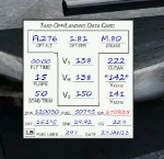
New features in this version are in indicated in '[ ]'.
Twenty call-outs sounds integrated into gauge [13 new call-outs].
Take-off V-Speeds calculated for Flaps 5, 15, or 25 with temperature and altitude adjustments.
[Take-off speed bugs and Command speed bug automatically set for: V1/Vr, V2, V2 + 15].
[Flaps-up maneuvering speed (clean speed) bug set after flaps-up].
Optimum altitude and optimum EPR (EPR calc for M.80) are continually calculated.
Gross Weight overage will display in 'red' text. Tooltip indicates overweight value (LB/KG).
Take-off trim calculated for current gross weight.
Maximum Climb Thrust (MCT) calculated based on current TAT temperature.
[Current EPR displayed adjacent to MCT for ease of use during climb phase].
Display units can be toggled between LB and KG (default LB).
Outside air Temperature can be toggle between Fahrenheit and Celsius.
Resettable fuel use.
Resettable flight timer.
[Selectable Vref landing configurations, Vref30 (default) or Vref40].
[Approach / landing speed bugs and Command speed bug automatically set for: Vref, Vref + 5, Vref + 15].
ZFW, Fuel, CG, Gross Weight and Barometric Pressure MSL (QNH) displayed.
['Barometer Set' call-out occurs when pressing keyboard letter 'B' (V-One gauge must be open)].
[Airspeed gauge enhanced: CMD speed bug colorized orange and notch added for visibly of tick marks below].
[Decision Height adjustment now on Data Card in hidden click-spot located on upper right corner].
[Now installation to a single location will work for all variants].
| Filename: | VOne_Gauge_for_Boeing_727100200F_Complete.zip |
| License: | Freeware, limited distribution |
| Added: | 28th January 2013, 11:30:53 |
| Downloads: | 1,512 |
| Author: | Paul Tally |
| Size: | 3.55 MB |
| Category: Flight Simulator X - Scenery | |
| KSNA, John Wayne-Orange County Airport |
|
Images related to this file:
File Description:

John Wayne Airport (IATA: SNA, ICAO: KSNA, FAA LID: SNA) is an airport in an unincorporated area in Orange County, California, with its mailing address in the city of Santa Ana, which is also the county seat, hence the International Air Transport Association (IATA) airport code. The main entrance to the airport is off of MacArthur Blvd in Irvine, the city that abuts the airport from the north and east. Newport Beach and Costa Mesa form the southern and western boundaries, respectively, together with a small unincorporated area along the Corona del Mar (73) Freeway. Santa Ana lies just north, not actually touching the airport directly. Originally named Orange County Airport, the county Board of Supervisors renamed it in 1979 to honor the actor John Wayne, who resided in neighboring Newport Beach and died that year. It also became the first airport to be named after an entertainer.
The main runway, at 5,701 feet (1,738 m), is one of the shortest of any major airport in the United States, resulting in most passenger aircraft operating from the airport to be no larger than the Boeing 757. However, some larger cargo aircraft, such as the FedEx A310/300, fly from SNA. Some gates are built to handle planes up to the size of a Boeing 767, which can operate with payload/fuel load restrictions. No wide-body passenger aircraft are currently in scheduled service at the airport.
| Filename: | KSNA_John_WayneOrange_County_Airport.zip |
| License: | Freeware, limited distribution |
| Added: | 11th October 2011, 08:25:20 |
| Downloads: | 11,005 |
| Author: | Mateusz Stabryla MK-Studios |
| Size: | 66.92 MB |
| Category: Flight Simulator X - Aircraft Repaints, Textures and Modifications | |
| Consolidated PBY-5 RNZAF 6 Sqn XX-N |
|
Images related to this file:
File Description:

A repaint for the Aerosoft PBY-5 Catalina in the colors of PBY-5 (Bu08450) NZ4012 XX-N 'The Naughty Nine" of the RNZAF, as it looked while flying with FltLt Guy Rogers and crew from the Solomon Islands in 1945 with 6 Flying Boat Squadron. Following Japan's entry into the war in December 1941, the RNZAF had to switch from primarily training pilots to Europe into a combat force. No. 6 Squadron RNZAF was formed as an army co-operation unit at Milson in February 1942 flying Vickers Vildebeest and Hawker Hind aircraft. At the same time, No. 5 Squadron RNZAF moved to Fiji with Short Singapores and Vickers Vildebeest and Vincent biplanes. Modern maritime patrol flying boats (and more Hudson light bombers) were requested under Lend Lease and when the first Consolidated Catalinas arrived a detachment of men from No. 5 Squadron was assigned to convert to these types as No. 6 Squadron. Before the squadron was officially formed these men successfully completed their first air-sea rescue of a downed US aircrew. From May 1943 No. 6 squadron undertook action against the Japanese. The Squadron also conducted search and rescue missions for allied aircrew and seamen, and undertook many open sea rescues. XX-N arrived in Fiji on 20 june 1943. It was declared surplus to requirements in 1951, and was broken up in Hobsonville in 1952.
Repaint by Jan Kees Blom, based on the paintkit by Aerosoft
| Filename: | Consolidated_PBY5_RNZAF_6_Sqn_XXN.zip |
| License: | Freeware |
| Added: | 13th July 2018, 20:40:11 |
| Downloads: | 132 |
| Author: | Jan Kees Blom |
| Size: | 9.44 MB |
| Category: Flight Simulator X - Scenery | |
| RAF Honeybourne 1945 - Worcestershire, England |
|
File Description:
RAF Honeybourne was a Royal Air Force station located 0.6 miles (0.97 km) south of Honeybourne, Worcestershire, England and 4.6 miles (7.4 km) east of Evesham, Worcestershire, England.
The airfield was home to No. 24 Operational Training Unit RAF (OTU) which used Vickers Wellingtons and Armstrong Whitworth Whitleys from 15 March 1942 until July 1945 flying many operational bombing and leaflet dropping operations.
A number of units from Ferry Command were based here including a ferry training unit using Lockheed Hudsons and Bristol Beauforts.
The airfield was also temporarily home to No. 21 OTU flying Wellingtons from RAF Enstone from August 1945 for two months because the runways at their home base were being repaired. From October 1945 until 1946 107 Sub Storage Unit from No. 8 Maintenance Unit used the airfield for storing Wellingtons and General Aircraft Hamilcar gliders.
The role of the airfield after the war changed with the reduction of flying movements and with a slight change in what the units did on the airfield when No. 107 Sub Storage Unit from 1947 began to collect no longer needed Wellingtons which were then scrapped and taken to Weston Subedge goods yard (which was near to the south-western corner) where the railway would take them to the necessary destination.
In July 1948 the site was closed and much has reverted to farmland with runways being removed in 1968. Since then, the airside area has evolved into the Honeybourne Airfield Trading Estate with the five hangars being used for different purposes.
| Filename: | RAF_Honeybourne_1945__Worcestershire_England.zip |
| License: | Freeware |
| Added: | 3rd June 2016, 11:00:06 |
| Downloads: | 131 |
| Author: | Terry Boissel |
| Size: | 2.29 MB |
| Category: Flight Simulator X - Scenery | |
| RAF Bircham Newton - Norfolk, England |
|
File Description:
RAF Bircham Newton is a former Royal Air Force station located 2.1 miles (3.4 km) south east of Docking, Norfolk
and 13.4 miles (21.6 km) north east of King's Lynn, Norfolk, England.
The site was first used during the First World War and received the largest British bomber of the time, the Handley Page V/1500. They would have carried out bombing missions against Berlin but the Armistice was arranged before any missions were actually flown.
The airfield was equipped with one aircraft repair shed and three double bay general service sheds, although these had been demolished by 1937. It had two Belfast hangars, three C Type hangars, three Bellman hangars and ten Blister hangars. It operated through the Second World War as part of No. 16 Group RAF as part of Coastal Command.
No. 206 Squadron RAF was one of the squadrons being based there, on maritime patrol duties. Two satellite airfields, RAF Docking and RAF Langham were opened to accommodate units. In 1965 the airfield was used for evaluation trials of the Hawker Siddeley Kestrel V/STOL aircraft.
After closure as an operational airfield in 1966, the airfield became the home of the Construction Industry Training Board. The runways have gone, but the majority of buildings on the site, including some hangars and the control tower, remain in use by the CITB.The control tower was demolished in 2010 due to its poor condition. Constructionarium is also based within the estate, providing a week's practical learning opportunity for undergraduates
| Filename: | RAF_Bircham_Newton__Norfolk_England.zip |
| License: | Freeware |
| Added: | 25th December 2015, 18:15:50 |
| Downloads: | 360 |
| Author: | Terry Boissel |
| Size: | 1.6 MB |
| Category: Flight Simulator X - Scenery | |
| YKLN Kulin Town and YJLN Kulin, Jilakin Rock, Western Australia |
|
File Description:
YKLN Kulin Town and YJLN Kulin, Jilakin Rock. Kulin is located in the upper great southern Wheatbelt of Western Australia, the Shire of Kulin covers an area of 4,790 square kilometres. It encompasses the towns of Kulin, Pingaring, Dudinin, Jitarning, and Holt Rock. The Kulin economy is based on agriculture and was settled by pastoralists in 1905. The crosswind runway is actually 7 miles to the east at Jilakin Rock and slopes uphill to the east. For convenience, I have used fictitious YJLN. Jilakin Downs is a Dorper sheep stud farm and the home of the Kulin Bush Races. Dorpers are currently under a cloud in Western Australia as the local abatoirs claim their hair is contaminating the meat and won't accept them. "We welcome air traffic to our 2012 Kulin Bush Races Weekend. A crosswind airstrip is available, with a shuttle bus service to the Jilakin Track. GPS position is S32-39-95 E118-18-71 and the elevation is 950 feet. The strip is 7 nautical miles east of the town of Kulin. Camping and toilets are close to the strip so that you can camp near your plane.
Kulin airstrip is also available for landing and takeoff during the weekend, a shuttle bus is available to take you out to the race track. If this option is chosen please contact Barry West. Please contact Barry West for flying information on 9880 9021" www.kulin.wa.gov.au/tourism_and_local_events/kulin_bush_races/flying_visit.html REQUIRES Blencowe_LibraryKit.zip
REQUIRES blencowe_librarykit_309494.zip (Available HERE)
| Filename: | YKLN_Kulin_Town_and_YJLN_Kulin_Jilakin_Rock_Wester.zip |
| License: | Freeware |
| Added: | 28th February 2013, 13:52:31 |
| Downloads: | 225 |
| Author: | Alan Blencowe |
| Size: | 5.73 MB |
| Category: Flight Simulator X - AFCAD Files | |
| Greenwood Lake Airport (4N1), NJ |
|
File Description:
Located 01 miles E of West Milford, New Jersey on 150 acres of land, Greenwood Lake Airport is a public asphalt strip that services small to medium GA air traffic. The second runway that used to be there has been re-paved and now serves as extra aircraft parking. You can park anywhere on the closed runway, along the edge of the main tarmac where the terminal building is, or between any two white cones (50 foot max wingspan) that mark tie-down locations in the middle of the main tarmac. A helicopter start is provided as well. For parking, Small GA spaces are for craft with wingspans of less than 50 feet; Medium GA spaces are for craft with wingspans from 50-60 feet. The glide slope for Runway 24 has been adjusted up from 3.5 degrees to 4 degrees as in real life the runway sits higher than the ground the trees grow from so this will give you proper clearance on approach. Fuel is available by stopping near the tank on the main tarmac. Scenery constructed with use of satellite images/streetview/aerial photos - the author has not been there in person. This scenery is meant to be used in conjunction with MegaScenery Earth New York 005. It is not required, but apron use is minimized to allow satellite scenery to show through as much as possible, and objects are placed based on the MSE textures - lack of it may make scenery look out of place.
| Filename: | Greenwood_Lake_Airport_4N1_NJ.zip |
| License: | Freeware |
| Added: | 22nd July 2011, 03:59:26 |
| Downloads: | 479 |
| Author: | Drew Sikora |
| Size: | 1.98 MB |
| Category: Flight Simulator X - Miscellaneous Files | |
| Drivable and Flyable Grey Van |
|
Images related to this file:
File Description:
The Drivable and Flyable Grey Van is derived from a stationary Euro Van model by the following modifications / additions:
-land-vehicle instrument panel
-sound files
-FSX effects and custom exhaust smoke effects files
-modified .CFG and .AIR files
The vehicle is powered by a single aircraft piston engine with modified flaps to serve as a gear-shift. High gear allows the vehicle to speed up to 70 Kt on wide highways, while the low gear restricts the speed to about 12 Kt, but enables the vehicle to ascend steep slopes for exploring terrain scenery.
At speeds around 65-70 Kt (in gear 4), pulling back on the yoke will allow the vehicle to take off and fly at level-flight speeds around 70 Kt. This is an interesting way to go island-hopping, overcome insurmountable terrain obstacles, or cover larger straight-line distances without using the slew mode.
An autopilot with hold altitude and hold heading options is operable during flight only.
All dashboard instruments are fully functional, including the Radio-Magnetic Indicator (RMI) during flight. Needles 1 and 2 are activated if correct frequencies are entered in the ADF and VOR radios.
The vehicle has lights which are toggled by pressing [L]. Lights are associated with a very thin exhaust smoke effect. Thick exhaust smoke is toggled by pressing [I].
Driving vehicles through FSX scenery in different seasons presents a whole new aspect to the simulation. It allows us to imagine discovering innumerable places on the planet which are in practice beyond our reach.
I hope you enjoy!
| Filename: | Drivable_and_Flyable_Grey_Van.zip |
| License: | Freeware |
| Added: | 29th January 2024, 15:24:50 |
| Downloads: | 37 |
| Author: | Rudy E. Kokich |
| Size: | 38.63 MB |
| Category: Flight Simulator X - Aircraft Repaints, Textures and Modifications | |
| FSX Canadian Airlines (Concept) Boeing 737-MAX10 |
|
Images related to this file:
File Description:

This is a repaint for the amazing TDS Boeing 737-MAX10. It includes the base model, high-quality textures, a VC, and custom ground service vehicles.
Canadian Airlines never flew the Boeing 737-MAX10, as by the time the company was absorbed by Air Canada in 1999 the aircraft did not exist. Canadian Airlines did fly a fleet of 77 737-200's and -300's. However, in our new universe, Canadian Airlines has taken delivery of one single Boeing 737-MAX10, available to fly any route of your choice. It flies under the registration C-FCDS and the tail number 731.
Livery Info
This is a concept livery created completely by me. I'd like to think if Canadian Airlines still existed, they would be thinking about rebranding into this wonderful, modern livery. It features Canada Goose on the tail and red and blue styling representing the mountains and sea; two of Canada's most stunning natural features. The engines are also splashed with some red, and the Canadian Airlines Chevron adorns the belly of the aircraft, as well as on the Sharklet wingtips.
MAX VC and Cockpit Info
This aircraft includes a VC updated to closer resemble the true-to-life MAX cockpit. The VC is the Microsoft/Alejandro Rojas Lucena/FSND base modified by Speedbird77 including gauges by G. Munro. I have also modified the 2d panel. I increased the size of the PFD and MFD to better fill the panel. If you don't like this modification, you can search for the original panel included in the base model.
| Filename: | FSX_Canadian_Airlines_Concept_Boeing_737MAX10.zip |
| License: | Freeware, limited distribution |
| Added: | 26th April 2024, 13:36:31 |
| Downloads: | 148 |
| Author: | Julian Flight |
| Size: | 81.27 MB |


© 2001-2026 AVSIM Online
All Rights Reserved
Privacy Policy |