
Where Flight Simulation Enthusiasts Gather from Around the World!
AVSIM Library - Search Results

| Category: Flight Simulator 2004 - Scenery | |
| Fs Sky World 2004 v1.005 |

|
File Description:
Fix the compatibility with Windows 98, Windows 2000 and XP and fix few broken sky that’s cause crash to Fs 2004, plus some others minor fix, light,sun, little bit change and de-saturated the Fixed Dawn & Dusk set 1 to set 5.
| Filename: | Fs_Sky_World_2004_v1005.zip |
| License: | Freeware, limited distribution |
| Added: | 9th March 2005, 13:41:23 |
| Downloads: | 16,241 |
| Author: | Chris Willis |
| Size: | 1.75 MB |
| Category: Flight Simulator 2004 - Scenery | |
| RJST - Matsushima Air Base - Miyagi Japan |
|
Images related to this file:
File Description:
This project represents Matsushima Air Base (RJST) in Miyagi Japan, home of the the F-2 training for the JASDF and the Blue Impulse aerobatic team. Matsushima was heavily damaged by the tsunami following the 2011 Tohoku earthquake and is in the process of extensive rebuilding and remodeling.
Included are scenery for Matsushima and paints and flight plans for the F-2B aircraft of 21 Squadron. The full squadron is represented even though only a few of them have been fully repaired and returned to service since the tsunami.
To use the AI aircraft, you will need the HTAI F-16D drag chute models.
| Filename: | RJST__Matsushima_Air_Base__Miyagi_Japan.zip |
| License: | Freeware |
| Added: | 27th October 2015, 12:18:16 |
| Downloads: | 784 |
| Author: | Brent Newman |
| Size: | 4.71 MB |
| Category: Flight Simulator 2004 - Scenery | |
| Fresno, CA KFAT |
|
File Description:
This is a small enhancement to Fresno Air Terminal. It will liven things up a bit at this small California airport. Jetways and a new terminal building with lighting as well as an accurate AFCAD are included. Many thanks to the guys at RWY12 and S. Ansari for the programs and macros which make this possible.
| Filename: | Fresno_CA_KFAT.zip |
| License: | Freeware |
| Added: | 29th October 2005, 05:31:57 |
| Downloads: | 3,024 |
| Author: | William Morgan/FRF Studio |
| Size: | 523.8 KB |
| Category: Flight Simulator 2004 - Scenery | |
| Cottonwood, AZ Photoreal |
|
File Description:
Photo scenery of Cottonwood, AZ based on 1992 USGS black & white aerial photos that have been colorized. The file includes full autogen, custom AFCAD and new generic buildings. Cottonwood is located in northern Arizona, just west of Sedona.
| Filename: | Cottonwood_AZ_Photoreal.zip |
| License: | Freeware |
| Added: | 22nd December 2006, 12:31:44 |
| Downloads: | 1,453 |
| Author: | Kevin Burns |
| Size: | 6.36 MB |
| Category: Flight Simulator 2004 - Scenery | |
| KSNC Chester, Connecticut (formerly 3B9) |
|
Images related to this file:
File Description:
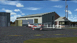
Chester is a small public-use airport in southeastern Connecticut. There is almost always a crosswind on the short, narrow runway. Sharp dropoffs at both ends of the strip make for a tricky approach, but if you can manage it, you'll be rewarded with a neat little airport surrounded by the gorgeous scenery of the Connecticut River Valley. The FBO is top-notch, fuel prices are the best around, and it's one of the last places still selling 80-octane.
Custom Gmax scenery and photo textures. AI traffic with default aircraft included.
| Filename: | KSNC_Chester_Connecticut_formerly_3B9.zip |
| License: | Freeware, limited distribution |
| Added: | 15th November 2009, 00:43:41 |
| Downloads: | 667 |
| Author: | Dave Athay |
| Size: | 1017.03 KB |
| Category: Flight Simulator 2004 - Scenery | |
| EDAM Zweibrucken Air Base, Zweibrucken, Germany |
|
Images related to this file:
File Description:
This scenery represents Zweibrucken Air Base in Germany as it was during 1990. At this point, the base was the home to the reconnaissance Phantoms of the 38th TRS/26th TRW. Also based here were the C-23 Sherpa's of the 10th MAS, which played a huge role in the European Distribution System, providing spares and supplies to bases throughout Europe without the cost of using larger cargo aircraft.
The scenery has been constructed using objects mainly from MAIW sceneries, which will need to be installed in order to gain the full visual experince.
| Filename: | EDAM_Zweibrucken_Air_Base_Zweibrucken_Germany.zip |
| License: | Freeware |
| Added: | 1st April 2013, 14:08:32 |
| Downloads: | 1,300 |
| Author: | Brian Clarke, Stewart Pearson, Daryl Payne |
| Size: | 757.24 KB |
| Category: Flight Simulator 2004 - Scenery | |
| Cape Girardeau Regional |
|
File Description:
FS2004 Scenery - Cape Girardeau Regional Airport (IATA: CGI, ICAO: KCGI) is a public airport located five miles (8 km) southwest of the central business district (CBD) of Cape Girardeau, a city in Cape Girardeau County, Missouri, USA. The airport covers 557 acres (225 ha) and has two runways. It is used for general aviation. Created using Instant Scenery. Libraries listed. Created With assistance from David "Opa" Marshall, by John B. Loney, Jr.
| Filename: | Cape_Girardeau_Regional.zip |
| License: | Freeware, limited distribution |
| Added: | 3rd August 2008, 17:02:06 |
| Downloads: | 783 |
| Author: | John B. Loney, Jr. |
| Size: | 1.18 MB |
| Category: Flight Simulator 2004 - Scenery | |
| Camp Dawson 3G5 |
|
File Description:
Camp Dawson 3G5 WV is a real world training post for ARNG and others in northern West Virginia. I don't like making military sceneries very accurate for obvious reasons. The runway and the roads are close to what you see as you fly over the Camp. My afcad is included inside the scenery folder. Thanks to those AVSIM object makers and credits are in readme file.
| Filename: | Camp_Dawson_3G5.zip |
| License: | Freeware |
| Added: | 27th August 2005, 01:30:52 |
| Downloads: | 1,013 |
| Author: | Rick Connolly |
| Size: | 2.73 MB |
| Category: Flight Simulator 2004 - Scenery | |
| EZ Scenery Cass Field (00CO) |
|
File Description:
FS2004 EZ Scenery CASS FIELD (00CO)
Briggsdale Colorado and surrounding parts of Eastern Co are well known for seeds. Seeds of almost any
kind imaginable like flowers, potatoes, bird seed and the list goes on and on. It is most always windy for there are no trees to slow the flow. Hot & windy in summer, cold and windy in winter and no natural enviromnent to harm plant growth. You can see the mountains to the west and more desolation to the east. A lonely place to drive through but rich in good people and seeds harvested for the world.
Area outside of airport's default flatten area require FS Global or Abasus extreme landscapes for elevation data. Download FREE library of RWY12 - EZ scenery objects (available on FlightSim.com or AVSIM) for objects. Ultimate Terrain USA for detailed landclass. FSX compatable.
Instructions inside.
jimmy R martin
| Filename: | EZ_Scenery_Cass_Field_00CO.zip |
| License: | Freeware |
| Added: | 6th June 2006, 01:54:47 |
| Downloads: | 619 |
| Author: | jimmy R martin |
| Size: | 255.55 KB |
| Category: Flight Simulator 2004 - Scenery | |
| N-43 Braden Airpark Easton, Pennsylvania USA |
|
Images related to this file:
File Description:

N43 Braden Airpark. Easton, PA. I live close by this wonderful short field airport. I wanted to model this one for a few years. I went out and took some pictures to get it as close to real as possible. Credit also to Matthias Rauh for allowing me to use some of is textures from his beautiful work on KPLN Pellston, MI.
| Filename: | N43_Braden_Airpark_Easton_Pennsylvania_USA.zip |
| License: | Freeware, limited distribution |
| Added: | 24th September 2012, 22:59:26 |
| Downloads: | 266 |
| Author: | Rob Touchtone |
| Size: | 6.06 MB |


© 2001-2026 AVSIM Online
All Rights Reserved
Privacy Policy |