
Where Flight Simulation Enthusiasts Gather from Around the World!
AVSIM Library - Search Results

| Category: Flight Simulator 2004 - Scenery | |
| New Detail Texture |

|
File Description:
Upgraded detail texture for FS9:COF, it should also work with FS2002. Works great for low flying in rural areas, less so for cities (acceptable though). Also improves texture on distant terrain/mountains. More repetitive than the standard detail texture.
| Filename: | New_Detail_Texture.zip |
| License: | Freeware, limited distribution |
| Added: | 6th December 2003, 07:25:53 |
| Downloads: | 1,413 |
| Author: | Daniel Buechter |
| Size: | 193.77 KB |
| Category: Flight Simulator 2004 - Scenery | |
| Replacement Dynamic Water Textures v11 |
|
File Description:
Replacement dynamic water texture-sets for FS2004 (VERSION 11). These newer version 11 moon light textures are a completely new type than my earlier versions. The results are much improved and there is also a "new moon" texture in this version which is a more realistic and darker blue/black which contrasts nicely with my moon light textures. This compares quite drastically to the default over lit pinkish brown tones the default FS9 uses for a new moon. Now when you fly by moonlight you can actually see the moon kissed water and even see some wave action. It actually feels like you are there! There are 2 moon light textures in this download. The default reflections and water colors leave a lot to be desired in FS2004. As an example; The default milky "bright green" overcast texture is highly unrealistic in overcast conditions. The replacement textures will change this dramatically to a much more convincing and realistic "blue/grey", cast, with improved lighting and reflections in respect to the sun. These replacement textures will generally give a much more realistic tone and color to the water effects in FS2004. The change is quite dramatic and transforms the flight sim experience to a much greater level of realism. It is important to stress the default FS9 textures are fully compatible with these new textures and they can be used in any combinations and can be mixed and matched with the new textures. For example it may be that some users want to keep some of the water environment textures as they are by default but change only one or two textures. The choice is yours. As a further added bonus a voice control file has been included for "Shoot" which will control FS2004 by voice. It is brilliant and it's free.
| Filename: | Replacement_Dynamic_Water_Textures_v11.zip |
| License: | Freeware |
| Added: | 11th January 2004, 20:38:03 |
| Downloads: | 3,057 |
| Author: | Peter Wilding |
| Size: | 3.49 MB |
| Category: Flight Simulator 2004 - Scenery | |
| Imporved CFG file and Patches Explained |
|
File Description:
Good framerates and nice scenery views require modification of the FS9.CFG file. Here is an improved FS9.CFG file with READ ME full of explanations and hints. Want sharp outside world-views and good framerates - then try this one!
| Filename: | Imporved_CFG_file_and_Patches_Explained.zip |
| License: | Freeware |
| Added: | 12th February 2006, 22:14:53 |
| Downloads: | 4,651 |
| Author: | John van Kampen |
| Size: | 80.71 KB |
| Category: Flight Simulator 2004 - Scenery | |
| Kent International Airport - Manston |
|
Images related to this file:
File Description:
Kent International Airport, Manston EGMH. Scenery and afcad changed to reflect what the Airport could look like in 2030. Based on rough sketch included in PDF file released recently by the Airports Owners.
| Filename: | Kent_International_Airport__Manston.zip |
| License: | Freeware |
| Added: | 19th February 2010, 15:10:31 |
| Downloads: | 638 |
| Author: | Douglas Clark |
| Size: | 461.13 KB |
| Category: Flight Simulator 2004 - Scenery | |
| Elizabeth City Coast Guard Air Station |
|
File Description:
This package is a complete re-do of CGAS Elizabeth City. The AFCAD is redone as well as some custom GMAX objects along with some RWY12 objects. There is parking for Jets, Jayhawks and Hercs. Enjoy.
| Filename: | Elizabeth_City_Coast_Guard_Air_Station.zip |
| License: | Freeware |
| Added: | 2nd August 2007, 01:09:42 |
| Downloads: | 1,196 |
| Author: | Jim Donlin |
| Size: | 205.37 KB |
| Category: Flight Simulator 2004 - Scenery | |
| Florida Keys Marathon Airport (KMTH) |
|
File Description:
The goal of this scenery was to improve the Marathon Airport in the Florida Keys (KMTH), while still keeping framerates high. Performance has been the #1 priority with this design. To achive this, I am careful not to use a large number of objects.
| Filename: | Florida_Keys_Marathon_Airport_KMTH.zip |
| License: | Freeware, limited distribution |
| Added: | 24th February 2006, 04:09:45 |
| Downloads: | 2,101 |
| Author: | Craig Swartzlander |
| Size: | 292.31 KB |
| Category: Flight Simulator 2004 - Scenery | |
| CYUX - Hall Beach - Nunavut, Canada |
|
Images related to this file:
File Description:
This is the Fox-Main DEW line station that I somehow omitted to include when I posted Hall Beach. It is all those large radar things in the background in the screen shot.
Just install it like any scenery, just below HallBeachCYUX in the FS9 library priority.
| Filename: | CYUX__Hall_Beach__Nunavut_Canada.zip |
| License: | Freeware, limited distribution |
| Added: | 11th May 2014, 13:44:09 |
| Downloads: | 222 |
| Author: | Roger Wensley |
| Size: | 864.63 KB |
| Category: Flight Simulator 2004 - Scenery | |
| SAE-1, First Soviet Antarctic Expedition |
|
Images related to this file:
File Description:
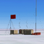
FS2004 Scenery - the First Soviet Antarctic expedition. This scenery represents three permanent Antarctic stations established by the First Soviet Antarctic expedition (Mirny, Pionerskaya, Oasis). By Alexander Belov
| Filename: | SAE1_First_Soviet_Antarctic_Expedition.zip |
| License: | Freeware, limited distribution |
| Added: | 2nd June 2010, 13:46:42 |
| Downloads: | 1,244 |
| Author: | Alexander Belov |
| Size: | 3.85 MB |
| Category: Flight Simulator 2004 - Scenery | |
| LTBQ - Cengiz Topel Naval Air Station Scenery |
|
Images related to this file:
File Description:
LTBQ - Cengiz Topel Naval Air Station Scenery created with ADE9 v.1.79 and static objects libraries with using the latest satellite images available from Google Earth.
| Filename: | LTBQ__Cengiz_Topel_Naval_Air_Station_Scenery.zip |
| License: | Freeware |
| Added: | 27th May 2023, 00:48:20 |
| Downloads: | 231 |
| Author: | Taner Akol |
| Size: | 8.57 MB |
| Category: Flight Simulator 2004 - Scenery | |
| Rangsdorf Airfield |
|
Images related to this file:
File Description:
Rangsdorf Airfield, the place where Graf Schenk von Stauffenberg once enter a aircraft to kill the fuehrer of the third reich adolf hitler. It was closed in 1990. In former times it was used by the soviet army as helicopter base. In the beginning, it was the homebase of buecker flugzeugwerke till world war II. The airfield is located ca. 2 miles south of Berlin-Schoenefeld Airport which will soon be Berlin-Brandenburg International.
| Filename: | Rangsdorf_Airfield.zip |
| License: | Freeware |
| Added: | 19th July 2014, 17:24:03 |
| Downloads: | 403 |
| Author: | David Kolas |
| Size: | 10.24 MB |
© 2001-2026 AVSIM Online
All Rights Reserved
Privacy Policy |