
Where Flight Simulation Enthusiasts Gather from Around the World!
AVSIM Library - Search Results

| Category: Flight Simulator 2004 - Scenery | |
| Pennsylvania 30 meter Mesh Scenery Revision |

|
File Description:
Pennsylvania 30 meter Mesh Scenery revision. "pamesh3.bgl" was replaced from "pa_30m_mesh2_8.zip". Removes the three erroneous mountain peaks from the area near Pittsburgh. Note: This download is a replacement for the original "pa_30m_mesh2_8.zip". If yo downloaded the original and the fix, you don't need this file.
| Filename: | Pennsylvania_30_meter_Mesh_Scenery_Revision.zip |
| License: | Freeware |
| Added: | 14th December 2003, 23:34:24 |
| Downloads: | 2,302 |
| Author: | Phil Cruikshank |
| Size: | 4.95 MB |
| Category: Flight Simulator 2004 - Scenery | |
| Hal Far Float Base, Malta |
|
File Description:
Hal Far Float Base is a large facility located just to the Southeast of Hal Far Royal Naval Air Station, Malta, circa WWII. The base is entirely ficticious. Aerosoft's "Islands of Malta" is required for this scenery to work. Default scenery places this floatbase entirely on land. See also O. Morris' "hal_far_v2.zip"
| Filename: | Hal_Far_Float_Base_Malta.zip |
| License: | Freeware, limited distribution |
| Added: | 25th April 2012, 02:38:53 |
| Downloads: | 170 |
| Author: | Stew Stewart |
| Size: | 9.86 MB |
| Category: Flight Simulator 2004 - Scenery | |
| Mulino in Oregon |
|
File Description:
This is an enhancement of a stock airport in Mulino, Oregon. In your flightsim it is listed under Portland, Oregon. ILS for rwy 14, VOR and NDB. fuel station works.
| Filename: | Mulino_in_Oregon.zip |
| License: | Freeware |
| Added: | 12th January 2006, 05:42:51 |
| Downloads: | 776 |
| Author: | Robert M. Lacy |
| Size: | 4.89 MB |
| Category: Flight Simulator 2004 - Scenery | |
| VEAT Argatala, India |
|
Images related to this file:
File Description:
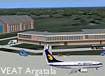
Googly scenery for VEAT Argatala, India - one of the airports that Microsoft seem to have, um, "forgotten" in FS2004. In the real world it is regularly served by Boeings and Airbii of Alliance Air, Indian Airlines, Jet Airways and Kingfisher Airlines (and smaller aircraft), using the 6000 foot runway with little room for manoevre. These scenery files add aprons, taxiways, buildings and other airport features to Flight Simulator's bland representation and allow you, and "AI" traffic, to land, taxi, park and take off realistically. The scenery does not purport to be ultra-accurate. Based on high-detail satellite imagery from Google Earth, the layout is proportianally correct but the added airport features, such as buildings, are built from default Microsoft objects and add-on libraries so will not look like the real thing. You are not obliged to download and install any additional scenery libraries, but to enjoy this scenery in its entirety, you may wish to. It will work fine, with or without. Details of optional additional scenery library downloads are provided within.
[File re-uploaded at request of AVSIM]
| Filename: | VEAT_Argatala_India.zip |
| License: | Freeware |
| Added: | 14th May 2010, 04:49:05 |
| Downloads: | 1,658 |
| Author: | John Hinson |
| Size: | 65.16 KB |
| Category: Flight Simulator 2004 - Scenery | |
| Aurangabad Domestic Airport [VAAU] |
|
Images related to this file:
File Description:
Aurangabad Airport is about 135nm East of Mumbai. Recently a New Apron has been added to the airport which has also been amended in the scenery. One of the runways i.e. Rwy 27 has ILS CAT II, Vor, Ndb - every basic requirement is available.Quick Short Flights to Mumbai is what one might enjoy . The other reason to fly in-out of this airport. ...well ... these screen shots might ....just...help you decide. 2 tiny mini terminal buildings and landscape gives a good frame rate.
| Filename: | Aurangabad_Domestic_Airport_VAAU.zip |
| License: | Freeware |
| Added: | 12th August 2010, 00:38:05 |
| Downloads: | 1,047 |
| Author: | Ashish Singh |
| Size: | 19.88 MB |
| Category: Flight Simulator 2004 - Scenery | |
| Gaya (VEGY) and Baghdogra (VEBD) |
|
Images related to this file:
File Description:
This is a simple scenery for both Indian airports: Gaya (VEGY) and Baghdogra (VEBD).
| Filename: | Gaya_VEGY_and_Baghdogra_VEBD.zip |
| License: | Freeware |
| Added: | 12th January 2010, 19:15:35 |
| Downloads: | 663 |
| Author: | Filipe Fonseca |
| Size: | 268.02 KB |
| Category: Flight Simulator 2004 - Scenery | |
| Quebec sceneries Enhancements Update |
|
File Description:
Enhanced sceneries and mesh update of the province of Quebec, Canada. Must be used with
Scenes_du_Quebec_2k4.zip and qc09_2K4a.zip, qc09_2K4b.zip, qc09_2K4c.zip,
qc09_2K4d.zip files (AVSIM files library).Installation procedure in INSTALLATION_SETUP.txt.
Mise � jour et nouvelles sc�¨nes de la province de Qu�©bec. Pour utiliser cette mise � jour, il faut obligatoirement avoir d�©j� install�© les sc�¨nes du Qu�©bec contenues dans Scenes_du_Quebec_2k4.zip (sur AVSIM). Inclus aussi une mise � jour des �©l�©vations de terrain (mesh - lod09) de la province de Qu�©bec (qc09_2K4a.zip, qc09_2K4b.zip, qc09_2K4c.zip, qc09_2K4d.zip sur AVSIM). L'installation des fichiers est d�©crite dans INSTALLATION_SETUP.txt.
| Filename: | Quebec_sceneries_Enhancements_Update.zip |
| License: | Freeware, limited distribution |
| Added: | 1st November 2009, 06:49:03 |
| Downloads: | 4,759 |
| Author: | Gilles Gauthier |
| Size: | 6.81 MB |
| Category: Flight Simulator 2004 - Scenery | |
| Kounos Airfield, Greece |
|
File Description:
FS2002/FS2004 Greek Scenery -- Kounos, Greece.
A small (fictional) grass airfield in Kounos,
southern Peloponnessos. Features broad
grass airstrips in classic X-layout and old
fashioned buildings which work particularly
well with 'older' classic aircraft. Includes
bonus sceneries: the Corinth Canal and the
'Themis(tocles) Float-plane Airfield, Marina,
which also features a 2,132 ft. dirt RW.
By Tia & Björn Hall
| Filename: | Kounos_Airfield_Greece.zip |
| License: | Freeware |
| Added: | 16th September 2003, 22:31:19 |
| Downloads: | 1,705 |
| Author: | Tia & Björn Hall |
| Size: | 7.77 MB |
| Category: Flight Simulator 2004 - Scenery | |
| Hydroport |
|
File Description:
This is a neat little airport 30k appx. west of cyvr (Vancouver,B.C>). It has VOR, NDB, ILS, & ai ready parking. Also there is a hangar with movable doors operated by your radio on NAV 1. All the pertinent numbers for all of the above are in the readme file. There are also some boats just off shore. The town is Nanaimo. There are some LAGO sound files in another file I will upload shorty.
| Filename: | Hydroport.zip |
| License: | Freeware |
| Added: | 12th January 2006, 05:37:55 |
| Downloads: | 1,915 |
| Author: | Robert Lacy |
| Size: | 5.57 MB |
| Category: Flight Simulator 2004 - Scenery | |
| Asheville Regional Airport (KAVL) |
|
Images related to this file:
File Description:
Re-upload. This file updates Asheville Regional Airport (KAVL) with enhanced scenery. I tried to be as accurate as possible, however I could only find one top-down satellite photo to work from. I had to use some common sense and some guessing, so the airport might not be totally accurate to the real world version. It still should be a significant improvement over the default. Keeping performance high is one of my main concerns. The scenery includes optional static aircraft which can be removed.
| Filename: | Asheville_Regional_Airport_KAVL.zip |
| License: | Freeware, limited distribution |
| Added: | 6th June 2010, 03:27:22 |
| Downloads: | 2,773 |
| Author: | Craig Swartzlander |
| Size: | 328.59 KB |
© 2001-2026 AVSIM Online
All Rights Reserved
Privacy Policy |