
Where Flight Simulation Enthusiasts Gather from Around the World!
AVSIM Library - Search Results

| Category: Flight Simulator 2004 - Scenery | |
| Kangiqsualujjuaq CYLU in northern Quebec, Canada |

|
Images related to this file:
File Description:
Kangiqsualujjuaq is in northern Quebec on the east side of Ungava Bay, which is to the east of Hudson Bay and around 150 miles wide and 120 miles deep. Kuujjuaq, the administrative capital of northern Quebec, is 100 miles to the southwest. The town is on the bank of the George River, and has also been known as Fort George River, George River, etc. There was a Hudson Bay trading post at the town's location as early as 1838, though it was closed and reopened more than once and the town did not grow because of the trading post; the Inuit lived on the coast during the summer but moved 30 miles inland in winter for trapping. A cooperative was formed in 1959 to market fish, and this was the creative force that brought about establishment of the town; a school was built in 1963.
The airport is to the north of the town in a valley between the surrounding hills at 215 feet ASL. The gravel runway is just over 3,500 feet long and aligned 16/34; there is no PAPI, but there is fuel available, both 100LL and JetA. There are flights by Air Inuit and a warning of caribou on the runway during October and November.
| Filename: | Kangiqsualujjuaq_CYLU_in_northern_Quebec_Canada.zip |
| License: | Freeware, limited distribution |
| Added: | 1st February 2013, 21:24:55 |
| Downloads: | 277 |
| Author: | Roger Wensley |
| Size: | 2.76 MB |
| Category: Flight Simulator 2004 - Scenery | |
| PAAQ - Palmer Muni - Anchorage, Alaska - USA |
|
Images related to this file:
File Description:
Palmer PAAQ is in Alaska, some 40 miles northeast of Anchorage on the north side of Knik Arm and beside the west bank of the Matanuska River. It is for both GA and commercial aircraft. There are two apron areas, north and south, separated by the east-west runway. The north apron is for the Forestry Service planes and for resident GA tie-down places and hangars, along with maintenance facilities; the southern end of the north apron is for itinerant aircraft. The south apron is almost entirely for commercial companies and again maintenance. The main runway is just under 6,000 feet long, aligned L16-R34 and asphalted and lit, as is the parallel taxiway A. There is also a shorter and parallel runway that is grass and which receives no winter maintenance. The second main runway is 3,600 feet long and aligned 09-27, asphalt and lit and with a parallel taxiway B, also lit. The airport is undergoing a process of upgrading, which explains the varied colours (and age) of resurfaced taxiways. There are adjustment bgl's for two other neighbourhood airstrips, Toad Lake 24AK and Wolf Track 9AK8, which I just discovered buried in nearby holes in the ground; I also revised their runway surfaces.
| Filename: | PAAQ__Palmer_Muni__Anchorage_Alaska__USA.zip |
| License: | Freeware, limited distribution |
| Added: | 4th November 2014, 00:01:43 |
| Downloads: | 447 |
| Author: | Roger Wensley |
| Size: | 22.35 MB |
| Category: Flight Simulator 2004 - Scenery | |
| CYQU - Grande Prairie, Alberta, Canada |
|
Images related to this file:
File Description:
Grande Prairie is at 2,195 feet asl, 65 miles southeast of Dawsons Creek, 90 miles southwest of Peace River and around 60 miles east of the Rockies. The town has a population of 55,000 and growing. The airport is just to the west of the town and was originally a military base, built during WW2. The two runways are 07-25 and 11-29 and when one is the active runway then the other is used as a taxiway. AI in FS9 doesn't like this, and just stops at the first hold short without ever reaching the active runway. I have found a way to overcome this and AI will now use taxiway A and whichever runway is inactive to feed to and from both ends of the active runway. The vertical red tanks are for de-icing fluid; de-icing is carried out before take-off in the winter. The industrial area to the southeast is now larger than I have made it, but I kept it to this minimum size to keep frame rates down. All the buildings are modeled specifically for CYQU. The AI includes Westjet, Air Canada Jazz, and others as listed. The GA AI uses only FS9 standard aircraft.
| Filename: | CYQU__Grande_Prairie_Alberta_Canada.zip |
| License: | Freeware, limited distribution |
| Added: | 9th May 2014, 10:05:40 |
| Downloads: | 670 |
| Author: | Roger Wensley |
| Size: | 18.33 MB |
| Category: Flight Simulator 2004 - Scenery | |
| North Manitoba Airfields 20# in Canada |
|
Images related to this file:
File Description:
These are 20 airfields in north Manitoba, Canada. They were all previously posted individually But not on Avsim. There is a screenshot of Google Earth showing their names and locations amid other airfields. "Lodge" indicates the fact that there is a fishing lodge and airfield at that location but that I have no information to enable me to make the scenery. There are also some airfields that I downloaded years ago and are part of my FS9 set up, such as Flin Flon. There is AI with the supply flights that are vital for these isolated outposts. Gillam is a northern airfield that is connected to the rest of Canada by a railroad that continues north to Churchill Manitoba on the Hudson Bay coast and is used for grain exports during the ice-free summer months. A large number of the supply flights originate from Gillam. You may wonder about the numbers of fuel tanks at these airfields. These are not for the airfield use, they are for the settlement to be able to generate electricity and also to provide heating in the winter. If you find an error email me please, and note that my email address has been changed to rogwens at Gmail dot com.
| Filename: | North_Manitoba_Airfields_20_in_Canada.zip |
| License: | Freeware, limited distribution |
| Added: | 7th April 2021, 17:09:34 |
| Downloads: | 82 |
| Author: | Roger Wensley |
| Size: | 35.99 MB |
| Category: Flight Simulator 2004 - Scenery | |
| Rae Lakes CYRA at Gameti in the NW Territories Canada, corrected |
|
Images related to this file:
File Description:
This is a corrected version that rectifies the airfield elevation, which I forgot to include in the first post; 120 downloads and nobody tells me till now? The remainder of this is as first written, apart from the installation instructions: Gameti is a village in the Northwest Territories, around 65 miles north of Whati, which was recently posted. Until 2005 the village, which has a population of around 280, was known as Rae Lakes and the airfield is now renamed Gameti/Rae Lakes as shown in the 2010 version of the Nav Canada Flight Supplement, my standard reference year. Permanent settlement was established there in 1965 There is no all-weather road access and the village is reliant upon the airfield for supplies, along with an ice road in the winter months. The airfield is a mile or so east of the village, with a lit gravel runway of just over 3,000 feet aligned 14-32 and with PAPI at both ends. The airfield is served by Air Tindi from Yellowknife on an almost daily basis, included in the AI here along with some GA and a Friday delivery by a Buffalo DC3 that uses all of the runway. The runway has lake water at each end, ready for the unwary.
| Filename: | Rae_Lakes_CYRA_at_Gameti_in_the_NW_Territories_Can.zip |
| License: | Freeware, limited distribution |
| Added: | 30th November 2020, 18:04:00 |
| Downloads: | 136 |
| Author: | Roger Wensley |
| Size: | 3.9 MB |
| Category: Flight Simulator 2004 - Scenery | |
| VFR of Lario, Area C2A - Como lake, Italy |
|
Images related to this file:
File Description:
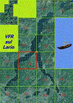
*** REPLACEMENT OF PREVIOUS ISSUE, due to a bug of an High Winter texture ***
This is the fifth scenery of the "VFR of Lario" project, made with photorealistic terrain (multiseason & night) and with some 3D GMax realistic objects.
Information: Como's lake is in the north of Italy, closed to the Helvetic border; this scenery covers approximately an area of 7.5x6 kmt, from la "Zoca de l'Oli" and mountains over Ossuccio (NW) to Tremezzo (NE), and from Colonno (SW) to Magreglio (SE) and includes the NLC piers of Sala Comacina, Comacina island, Campo, Lenno, Tremezzo, Bellagio (2), S. Giovanni, Lezzeno; it includes several dedicated buildings as Taverna Bleu hotel (Sala Comacina), S. Maria e S.Giacomo churches and villa Balbiano (Ossuccio), church and pier of S. Michele (Colonno), villa del Balbianello (Lenno), hotel Villa Marie, S. Lorenzo Church, villa La Quiete, Grand Hotel, villa Carlotta, hotel La Darsena, Pub motor ship Bisbino (Tremezzo), villa Melzi, villa Giulia, buildings Carillon e lungolago Manzoni, hotels Excelsior, Du Lac, Metropole (Bellagio). Two NLC ferry (moted on the way Bellagio-Cadenabbia) are placed together with other minor boats and docks placed alongside the coast, including platforms for seaplanes arrival.
Contents: GMax objects as above and other buildings, minor piers and boats together with autogen buildings and trees are fully spreaded on the scenery.
| Filename: | VFR_of_Lario_Area_C2A__Como_lake_Italy.zip |
| License: | Freeware |
| Added: | 22nd May 2012, 18:12:41 |
| Downloads: | 1,671 |
| Author: | Aldo Della Vedova, Daniele Lanfranchi, Gian Mario Verga, Diego Caligiuri |
| Size: | 28.49 MB |
| Category: Flight Simulator 2004 - Scenery | |
| Mackenzie CYZY in British Columbia, Canada |
|
Images related to this file:
File Description:
Mackenzie is around 120 miles west of Peace River and the BC/Alberta border, at the southern end of Williston Lake. The lake is 135 miles long and the population of the town is about 3,500; those figures illustrate typical Canada, a huge area enjoyed by the few. The main occupations relate to timber and mining in some form, plus tourism (in particular winter sports tourism). The airport is 2 miles southwest of the town, with no regular scheduled flights but it is not unusual to find Central Mountain Air there delivering either charter passengers or freight. The single runway is aligned 16-34 and 100 feet wide lit asphalt that is just over 5,000 feet long, with (in 2010 or so) an additional 1,500 feet of gravel. There is PAPI at both ends of the asphalt. The largest operation based at the airfield is a helicopter company, at the northern end of the apron. There is a "mandatory frequency" of 123.5 which is a Canadian invention; you MUST have a radio. There is no control tower at the actual airfield, and if or when there is no response from further afield then you announce your intentions etc. In FS9 there is no way to "switch off or on" the monitoring of a MF radio frequency so you will find that this one is always silent.
| Filename: | Mackenzie_CYZY_in_British_Columbia_Canada.zip |
| License: | Freeware, limited distribution |
| Added: | 27th December 2018, 20:19:05 |
| Downloads: | 133 |
| Author: | Roger Wensley |
| Size: | 19.81 MB |
| Category: Flight Simulator 2004 - Scenery | |
| Rae Lakes CYRA at Gameti in the Northwest Territories, Canada |
|
Images related to this file:
File Description:
Gameti is a village in the Northwest Territories, around 65 miles north of Whati which was recently posted. Until 2005 the village, which has a population of around 280, was known as Rae Lakes and the airfield is now renamed Gameti/Rae Lakes as shown in the 2010 version of the Nav Canada Flight Supplement, my standard reference year. Permanent settlement was established there in 1965. There is no all-weather road access and the village is reliant upon the airfield for supplies, along with an ice road in the winter months. The airfield is a mile or so east of the village, with a lit gravel runway of just over 3,000 feet aligned 14-32 and with PAPI at both ends. The airfield is served by Air Tindi from Yellowknife on an almost daily basis, included in the AI here along with some GA and a Friday delivery by a Buffalo DC3 that uses all of the runway. The runway has lake water at each end, ready for the unwary. A note here about my scenery making. There will not be many more to follow this as I am almost at the end of the photos I either took or found for scenery purposes, plus I expect to move on from FS9 at some point during next year.
| Filename: | Rae_Lakes_CYRA_at_Gameti_in_the_Northwest_Territor.zip |
| License: | Freeware, limited distribution |
| Added: | 26th December 2019, 19:32:09 |
| Downloads: | 124 |
| Author: | Roger Wensley |
| Size: | 4.81 MB |
| Category: Flight Simulator 2004 - Scenery | |
| Steamboat Springs (KSBS), Flat Tops Wilderness Area, Colorado - Photo-Scenery |
|
Images related to this file:
File Description:

Steamboat Springs (KSBS), Flat Tops Wilderness Area, Colorado, Photo-Scenery (FS9 & FSX)
The Flat Tops Wilderness Area, which is the second largest wilderness area in Colorado, is named for its many flat topped mountains that are clearly visible from the sky. Trappers Lake, located in the north of the area inspired Arthur Carhart, a US Forest Service official, to initiate a plea for Wilderness preservation as early as 1919. Finally in 1975, three years before his death in 1978, the Flat Tops were designated a wilderness area. No wonder he found the area so entrancing: Behind Trappers Lake loom majestic volcanic cliffs, and beyond them a vast subalpine terrain reluctantly yields to alpine tundra with an average elevation of about 10.000 feet. More than 100 lakes dot the country above and below numerous flat-topped cliffs. Steamboat Springs is an internationally known winter resort destination.
To explore the scenery depart from Steamboat Springs Airport (KSBS) or Yampa Valley Airport (KHDN) and head south. High resolution versions of this scenery for FS9 and FSX (much sharper, but larger and multiple downloads) are available at www.blueskyscenery.com/GNB_West2.html . The screenies are taken from the high-res versions, so expect this version to be slightly more blurry. Thanks to Joop Mak for providing custom AFCADs that correct airport layouts so that they align with the photo-textures! They are available at www.blueskyscenery.com/AFCADs.html . YourDonation@Work: Dedicated to James.
| Filename: | Steamboat_Springs_KSBS_Flat_Tops_Wilderness_Area_C.zip |
| License: | Freeware, limited distribution |
| Added: | 26th April 2010, 17:53:25 |
| Downloads: | 1,303 |
| Author: | Gottfried Razek - blueskyscenery.com |
| Size: | 91.57 MB |
| Category: Flight Simulator 2004 - Scenery | |
| CYYQ - Churchill Port & York Factory - Northern Manitoba, Canada |
|
Images related to this file:
File Description:
The main part of this scenery installs the Port of Churchill and the grain silos. Churchill CYYQ has been made by Sidney Schwartz, and this also adds AI and slightly modifies his parking to make a space big enough for Buffalo's C46. Churchill is in northern Manitoba, on the Churchill River where it empties into Hudson Bay. The town is accesible by air, by boat (once the winter ice melts) and most importantly by rail from the south. Grain from the Canadian prairies is hauled north and stored in Churchill for export to Europe by a sea route that is significantly shorter than any other, and there is a grain carrier included in the AI. Today there are perhaps 810 people living in Churchill, a slowly declining number. There are also a number of impressive polar bears. There was another port south of Churchill, but it was never completed, never connected to a railroad track, and never used. It was called Port Nelson, and was at the mouth of the Nelson River. Nearby, on the Hayes River, there is an old trading post called York Factory, built in 1684 and preserved as part of the living history of the north of Canada. The second scenery is for this, and for the nearby tourist camp called Silver Goose Lodge, which as the name suggests is for hunters. The large grassy area alongside the fort was for the trappers to camp on when they all arrived in early summer to trade the furs for goods.
| Filename: | CYYQ__Churchill_Port__York_Factory__Northern_Manit.zip |
| License: | Freeware, limited distribution |
| Added: | 23rd July 2014, 02:26:04 |
| Downloads: | 545 |
| Author: | Roger Wensley |
| Size: | 3.69 MB |
© 2001-2026 AVSIM Online
All Rights Reserved
Privacy Policy |