
Where Flight Simulation Enthusiasts Gather from Around the World!
AVSIM Library - Search Results

| Category: Flight Simulator 2004 - Scenery | |
| Rae Lakes CYRA at Gameti in the Northwest Territories, Canada |

|
Images related to this file:
File Description:
Gameti is a village in the Northwest Territories, around 65 miles north of Whati which was recently posted. Until 2005 the village, which has a population of around 280, was known as Rae Lakes and the airfield is now renamed Gameti/Rae Lakes as shown in the 2010 version of the Nav Canada Flight Supplement, my standard reference year. Permanent settlement was established there in 1965. There is no all-weather road access and the village is reliant upon the airfield for supplies, along with an ice road in the winter months. The airfield is a mile or so east of the village, with a lit gravel runway of just over 3,000 feet aligned 14-32 and with PAPI at both ends. The airfield is served by Air Tindi from Yellowknife on an almost daily basis, included in the AI here along with some GA and a Friday delivery by a Buffalo DC3 that uses all of the runway. The runway has lake water at each end, ready for the unwary. A note here about my scenery making. There will not be many more to follow this as I am almost at the end of the photos I either took or found for scenery purposes, plus I expect to move on from FS9 at some point during next year.
| Filename: | Rae_Lakes_CYRA_at_Gameti_in_the_Northwest_Territor.zip |
| License: | Freeware, limited distribution |
| Added: | 26th December 2019, 19:32:09 |
| Downloads: | 124 |
| Author: | Roger Wensley |
| Size: | 4.81 MB |
| Category: Flight Simulator 2004 - Scenery | |
| Bryce Canyon National Park (KBCE), Utah, Photo-Scenery |
|
Images related to this file:
File Description:
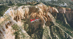
Bryce Canyon National Park (KBCE), Utah, Photo-Scenery (FS9 & FSX)
Despite its name, Bryce Canyon is not actually a canyon that was formed by a river, but rather a giant natural cliff shaped through erosion by wind, water, and ice. Bryce is distinctive due to its geological formations, delicate and colorful pinnacles called hoodoos that are up to 200ft high. The bizarre forms and red, orange and white colors of the rocks provide spectacular views. Unfortunately the hoodoos are too small for the elevation mesh in flight simulator. But you can enjoy the colors and shape of the cliffs. The cliffs in main region of the park, just south of the airport are partly covered
by snow. But on the southern and western part of the plateau you can enjoy them free of snow. Bryce Canyon is named after the Mormon pioneer Ebenezer Bryce who settled in this area in the 1850s. It was designated as a national park in 1928.
Bryce Canyon Airport (KBCE) just handles small aircraft on a daily basis. But is was actually built to handle larger aircraft in case of emergency. And so on Oct.6th 2000 an American Airlines MD-82 from Denver to Los Angeles made a successful emergency landing after reporting smoke in the cockpit and a loss of cabin pressure.
High resolution versions of this scenery for FS9 and FSX (much sharper, but larger and multiple downloads)are available at www.blueskyscenery.com/CNY_South2West4.html . The screenies are taken from the high-res versions, so expect this version to be slightly more blurry. Thanks to Joop Mak for providing a custom AFCADs that correct airport layouts so that they align with the photo-textures! They are available here: www.blueskyscenery.com/AFCADs.html . YourDonation@Work: Dedicated to Michael, Pat and Keith.
| Filename: | Bryce_Canyon_National_Park_KBCE_Utah_PhotoScenery.zip |
| License: | Freeware, limited distribution |
| Added: | 7th March 2010, 11:17:56 |
| Downloads: | 2,210 |
| Author: | Gottfried Razek, blueskyscenery.com |
| Size: | 96.35 MB |
| Category: Flight Simulator 2004 - Scenery | |
| Homer PaHO in Alaska US |
|
Images related to this file:
File Description:
Homer is a mainly GA airfield with rows of open air parking, but it also has scheduled flights, a terminal building, a long (for GA) runway of just under 6,700 feet that is 150 feet wide and aligned 03-21 with VASI on both ends and ILS on 03. So I think we can refer to it as an airport. Plus, at the time of this scenery (around 2010) there were three newly completed hangars on the north apron that I was told were for three companies, Bald Mountain Air service, Maritime Helicopters, and Pathfinder Aviation. I do not know which was for whom, but all three companies are in the helicopter and/or plane charter business. The south apron has a number of hangars and other buildings along it's length, starting at the western end with Smokey Bay Air that has an old control tower on the roof, then the Fire Station, and then Homer Air. I am not aware of who owns what after those first three, except that at the far eastern end there are several garages etc for the airport maintenance equipment. Next to the airport at that end there are a number of boat maintenance companies with boats pulled out of the water; this could not be well replicated due to the airport elevation above the sea level and a misplaced road. The nearby Beluga Lake 5BL float base is also included here, with some AI. The lake height above sea level has been adjusted to cope with too many cliffs intruding into the water; this is an annoying FS9 habit. The Homer scenery is as close to the actual airport as I could make it, while coping with inaccurate coast lines and roads, and grassed areas that could not all be modified for reasons that I will not bore you with. The Spit is a major scenery feature next to the airport, and I have added to this to provide some boats, docks, and nearby buildings etc. Small planes use the adjacent gravel taxi path instead of the runway when back-tracking to take off on runway 21. They only go as far as the path takes them and then u-turn onto the runway and take off. By the way, this airport's AI will function at its best if the prevailing wind makes 03 the runway in use. And I will eventually stop writing 03 and just call it 3, as the US, alone in the world, does not put a zero in front of 01, 02, 03, 04 etc. Just one other thing to note is that all access to the runway is from taxiways A and B; there was (in 2010) no access to the extreme western end of the runway as the taxiway there is marked as out of service pending a needed resurfacing.
If you find an error email me please, and note that my email address has been changed to rogwens at Gmail dot com.
| Filename: | Homer_PaHO_in_Alaska_US.zip |
| License: | Freeware, limited distribution |
| Added: | 28th July 2021, 03:31:04 |
| Downloads: | 131 |
| Author: | Roger Wensley |
| Size: | 11.86 MB |
| Category: Flight Simulator 2004 - Scenery | |
| Hana Heli-Obstacle Course v3.0 |
|
File Description:
Hana Airport is a regional airport of the State of Hawaii on the east shore of the island of Maui, 3 NM northwest of the unincorporated town of Hana. The airport covers 119 acres and has one runway. It is primarily a commuter facility used by unscheduled air taxis and general aviation. This scenery is intended as a single/multiplayer helicopter obstacle course where heli pilots can meet to compete, show off, and share their helo skills. Since birdseye (Timm Turner) already did a neat scenery called Hana_Scenery_PHHN (search for "hana" in the HoverControl Downloads), we decided to convert PHHN to a full helicopter training area. Makes a great place for helo pilots to gather to practice and perfect their skills, and challenge other pilots! And keep an eye-out for that Hot Air Balloon, cruising around an altitude of 3000 feet (don't forget to wave at them!).
Another unique thing about this scenery is the neighboring islands (Honolulu Intl/Hickam AFB, Bellows AFB, Lanai City, Kahului, Molokai, etc). If you get frustrated during your heli obstacle course training, just take a heading of 275 degrees, and relax at one of the neighboring islands. We also added an Easter Egg - If you set your FS calendar to July 21st, you'll see a large ridge fire up in the hills. Load Jordan Moore's Erickson S64E (http://www.hovercontrol.com/) & try your skills at water bombing!
| Filename: | Hana_HeliObstacle_Course_v30.zip |
| License: | Freeware |
| Added: | 28th August 2011, 17:53:18 |
| Downloads: | 468 |
| Author: | Greg Spellmen, Bob Ferguson |
| Size: | 95.52 MB |
| Category: Flight Simulator 2004 - Scenery | |
| Hana Heli-Obstacle Course v2.0 |
|
Images related to this file:
File Description:
Hana Airport is a regional airport of the State of Hawaii on the east shore of the island of Maui, 3 NM northwest of the unincorporated town of Hana. The airport covers 119 acres and has one runway. It is primarily a commuter facility used by unscheduled air taxis and general aviation. This scenery is intended as a single/multiplayer helicopter obstacle course where heli pilots can meet to compete, show off, and share their helo skills. Since birdseye (Timm Turner) already did a neat scenery called Hana_Scenery_PHHN (search for "hana" in the HoverControl Downloads), we decided to convert PHHN to a full helicopter training area. Makes a great place for helo pilots to gather to practice and perfect their skills, and challenge other pilots! And keep an eye-out for that Hot Air Balloon, cruising around an altitude of 3000 feet (don't forget to wave at them!). Another unique thing about this scenery is the neighboring islands (Honolulu Intl/Hickam AFB, Bellows AFB, Lanai City, Kahului, Molokai, etc). If you get frustrated during your heli obstacle course training, just take a heading of 275 degrees, and relax at one of the neighboring islands. We also added an Easter Egg - If you set your FS calendar to July 21st, you'll see a large ridge fire up in the hills. Load Jordan Moore's Erickson S64E (http://www.hovercontrol.com/) & try your skills at water bombing!
| Filename: | Hana_HeliObstacle_Course_v20.zip |
| License: | Freeware |
| Added: | 7th December 2010, 03:28:47 |
| Downloads: | 476 |
| Author: | Greg Spellmen & Bob Ferguson |
| Size: | 58.56 MB |
| Category: Flight Simulator 2004 - Scenery | |
| Carrier Division Two off Cape Cod |
|
File Description:
This scenery places the two Yorktown-class aircraft carriers of the pre-WW2 U.S. Navy with a screen of four cruisers at sea 100 miles due east of Provincetown, Massachusetts, on the tip of Cape Cod. The ships are the Virtual Navy's Task Force 16 relocated and with the Hornet posing as the Yorktown. This package contains the carriers, cruisers, ship wakes, AFCAD files for all six ships and Arrestor Cables catch zones for the carriers. It provides start points on both carriers, on the catapults of all four cruisers, and in the water between the carriers for seaplanes. Also included are flight starts for Paul Clawson's Curtiss SOC Seagull on the catapults of the cruisers and for the plane of your choice on the carriers, and authentic repaints of the SOC for aircraft assigned to the cruisers plus one for the personal aircraft of the Admiral commanding CarDiv2. There is also a selection of Golden Wings splash screens featuring the ships and planes of CarDiv2. Carrier Division 2 is being released in celebration of Golden Wings 3, but works just as well in a standard FS9 installation. Catapult floatplane operations require the Carrier Operations Gauge Package and Paul Clawson's Curtiss SOC Seagull or another catapult floatplane. Ships and wake effects by The Virtual Navy, modified AFCAD files, SOC repaints, flights and ship placement by Mick Morrissey. A big Thank you to the Virtual Navy for allowing this use of their ships!
| Filename: | Carrier_Division_Two_off_Cape_Cod.zip |
| License: | Freeware, limited distribution |
| Added: | 17th September 2005, 12:50:26 |
| Downloads: | 3,291 |
| Author: | Mick Morrissey |
| Size: | 5.19 MB |
| Category: Flight Simulator 2004 - Scenery | |
| VFR of Lario - Como lake, Italy |
|
Images related to this file:
File Description:
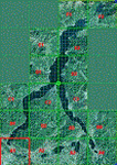
This is the first of the expected seventeen sceneries in the "VFR of Lario" project, that will include the full view of the Como Lake, made with photorealistic terrain (multiseason & night) and with 3D GMax realistic objects, including some motions. Further the Como seaplane airport, the project will include some other virtual ones, and all the piers of NLC (Navigation Lake Como). The project will be completed with a related AI seaplane traffic.
The "VFR of Lario" project REQUEST the installation of the scenery "Itcoast2.zip" & the related "ITAC2_P1.zip", both available for free download from different libraries.
Information: Como is the main and beautifull city on the namesake lake (called Lario), placed in the north of Italy, closed to the Helvetic border. It includes the AeroClub Como seaplanes international airport, with his own flight school. Como has the headseat of NLC, the fleet management for connection of forty Lario's piers. This first scenery covers approximately an area of 7.5x6 kmt.
Contents: airport water track with hangar and static seaplanes; breackwater and stadium lake front, war memorial monument, Volta's temple and lighthouse, main Cathedral, Social theater, city old towers and wall, villa Olmo, square Cavour's buildings, NLC main pier and some minor others, Como-Brunate's funicolar connection (animated), lake fountain, Tavernola shipyard, Baradello's castle, Valduce hospital; motor ships (animated), steamer, hydrofoils and other minor boats; several other buildings (GenericBuilding system), trees and lights widespread all over the scenery.
| Filename: | VFR_of_Lario__Como_lake_Italy.zip |
| License: | Freeware |
| Added: | 22nd December 2011, 23:30:47 |
| Downloads: | 3,551 |
| Author: | Aldo Della Vedova, Daniele Lanfranchi, Diego Caligiuri |
| Size: | 25.33 MB |
| Category: Flight Simulator 2004 - Scenery | |
| Sydney CYQY in Nova Scotia Canada |
|
Images related to this file:
File Description:
Sydney is a maritime port on the east coast of Canada, on the eastern corner of Cape Breton Island. It was founded in 1785 and grew in size emormously from 1900 as a steel mill was founded that prospered along with local coal mines until 1950 or so. After that date and following the final closure of the mill in 2001 the population declined to the current 29,000 or so. The airport is 3 or 4 miles southwest and inland of a coastal urban area which stretches from New Waterford in the north through Lingan, Dominion, Reserve Mines, and Glace Bay, to Port Caledonia, and 5 miles east of the town of Sydney which is beside a sheltered deep water harbour area. This version is not from a fixed date as although I had video of some of the buildings from 2010 I inadvertently constructed part of the apron layout from 2018 information, and then decided to keep it like that either because I liked it or perhaps was too lazy to redo it. The terminal building and the garages to the east of the terminal are original and old, though renovated and maintained to a fairly good standard. The other buildings on the airport are "hangars" in the expected form, with steel frames, insulated cladding, and pitched roofs. The airport publicises it's ability to cater for all the needs of visiting aircraft, with a large FBO hanger just beside the terminal. There are (or were, before the virus came along) scheduled flights by Westjet, Air Canada Jazz, and Air North, which are included in the AI along with GA flights. The runways are 07-25 at 7,000 feet and with PAPI on 25 and ILS on 07, and 01-19 at 6,000 feet with PAPI on 01 and ILS on 19. You will see once the scenery is installed that there are two folders in Sydney CYQY called "Scenery summer" and "scenery winter". Editing the folder name down from "scenery summer" to just "scenery" results in FS9 loading the summer ground textures and parked planes etc. In February you would edit down the "scenery winter" folder to just "scenery" and the unused and unswept taxiways, runway, and aprons will be invisible under the snow, the open-topped cars will not be parked in the open, and privately-owned planes will be in the hangars. If FS9 decides that there is snow on the ground then you need the winter textures, if not then the summer textures. The winter textures are not the full-snowdrift-middle-of-Winter-gale type and are more like early or late winter. One thing you must NOT DO is to edit both folders down at the same time.
| Filename: | Sydney_CYQY_in_Nova_Scotia_Canada.zip |
| License: | Freeware, limited distribution |
| Added: | 22nd August 2020, 00:07:58 |
| Downloads: | 277 |
| Author: | Roger Wensley |
| Size: | 29.42 MB |
| Category: Flight Simulator 2004 - Scenery | |
| OSM World: South America |
|
Images related to this file:
File Description:
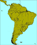
OSM World is a community project! If you wish to help, check the documentation and contact the author!
Welcome to OSM Wold: South America! This is a vector data scenery package covering the South American area. Coastlines, Rivers, lakes, roads, railways, and power lines with detail never before seen! All in an autogen-compatible density! You can see roundabouts, train terminals, harbor areas in a resolution of a point every 10 meters. At this same resolution a vectorial city class places residential (in small and big building variations, depending on surface area) and industrial areas exactly where they are supposed to be. This gives the city areas a resolution far superior to the capacity of FS-2004 default landclass bitmaps, limited to approximately 1 Km x 1 Km squares. OSM World: South America will even give you small roads leading to small towns (even a few houses across)! From big highway intersections, including ramps, to the tiniest rural pathways covering the entire South american area! Wherever in South America you fly, there is something to see!
You can enjoy this scenery near coastlines too! harbor areas and extremely detailed coastal topology (try the southern Chile). This scenery makes sure that the ocean is always flat, you can forget about the climbing water often found around photo-sceneries! This scenery is best paired with a good set of terrain meshes (like the freeware global SRTM mesh by Stephen Rothlisberger , available here: http://simviation.com/1/fs2004terrainmesh).
| Filename: | OSM_World_South_America.zip |
| License: | Freeware |
| Added: | 5th August 2015, 02:31:08 |
| Downloads: | 3,106 |
| Author: | Mario Noriega, Luis Miguel Hernandez |
| Size: | 64.37 MB |
| Category: Flight Simulator 2004 - Scenery | |
| Dawson Creek CYDQ in British Columbia, Canada UPDATED |
|
Images related to this file:
File Description:
This is a revised version of Dawson Creek CYDQ and the floats base CBD3, made primarily to provide one of the parked planes with it's textures but also to improve the apron markings and the AI. The float AI now includes Beavers and I also removed two planes that were not properly showing their textures in my current FS9 installation. The Beavers were included in my post of Nimpo Lake CAF8 and will need to be installed to show up here. This version is complete in itself and can be installed as-is if you do not have the original scenery. Dawson Creek is at 2,148 feet asl just east of the Rocky Mountains, less than 10 miles west of the BC/Alberta border and where the Rockies are at their narrowest. The population grew when the Northern Alberta Railway was extended to Dawsons Creek in 1932, and grew even more more when the Alaska Highway was built in 1942, starting from Dawsons Creek. In the 1950's the town was linked through the Rockies by a railway and a road to the BC interior, and the town grew again. Now it is static at just under 12,000 and once again has become a farming centre, with Fort St John and Grand Prairie winning out for new industry and commerce. The airport is just to the east of the town. The runway is 5,000 feet of wide asphalt (150 feet) aligned 06/24, lit, and with PAPI and approach lights. There is also a water runway for float planes, separately designated as Dawson Creek CBD3. The two effectively operate as one; traffic for both use the mandatory frequency of 122.2 and talk to one controller in one control tower. However, in FS9 the ATC for two separately designated airfields (or float fields) operates as if they are nowhere near each other and takes no notice of near misses between the two lots of planes. As a result I have put them both in un-manned tower mode so you will announce your position and intentions and select your own parking spots, either next to one of the hangars or on the grass. The aprons vary from asphalt, to concrete, onwards to gravel, and then further onwards to some gravel amid the bare dirt; I have replicated this variation as far as FS9 permits.
| Filename: | Dawson_Creek_CYDQ_in_British_Columbia_Canada_UPDAT.zip |
| License: | Freeware, limited distribution |
| Added: | 17th December 2018, 17:50:08 |
| Downloads: | 208 |
| Author: | Roger Wensley |
| Size: | 26.71 MB |


© 2001-2026 AVSIM Online
All Rights Reserved
Privacy Policy |