
Where Flight Simulation Enthusiasts Gather from Around the World!
AVSIM Library - Search Results

| Category: Flight Simulator 2004 - Scenery | |
| Port McNeill CAM8 float base in British Columbia, Canada |

|
Images related to this file:
File Description:
This is the seventh in a series of new and renovated float bases in BC. Port McNeill is a float base in a sheltered inlet on the northeast coast of Vancouver Island, close to the town and just under 20 miles east of the Port Hardy float base. There is no fuel available as the Port Hardy floatbase (already posted) acts as a refuelling centre for this and other float bases in the neighbourhood. The dock is to the west of the marina and east of the log raft area. The AI is a further adaptation of the CF36 AI and involves Beavers as listed in the AI folder. At Port McNeill all the AI works for both landing and takeoff for all of the planes, no matter what the wind direction is. All of these float bases can be installed together in the same folders, with a saving in duplicate textures. So a series called BC Floats (or whatever you want to call it) or individually installed float bases; your choice. The next in the series was suposed to be Sullivan Bay, another floating marina, but I digressed to Port Hardy and Port McNeill.
| Filename: | Port_McNeill_CAM8_float_base_in_British_Columbia_C.zip |
| License: | Freeware, limited distribution |
| Added: | 21st January 2017, 19:11:03 |
| Downloads: | 168 |
| Author: | Roger Wensley |
| Size: | 5.07 MB |
| Category: Flight Simulator 2004 - Scenery | |
| "Himalayan Peaks" LOD10 Mesh, Volume 5 - Garhwal |
|
File Description:
Highly detailed terrain mesh of the Garhwal area, N30°-32° E78°-81°. The files in this package are based on Shuttle Radar (SRTM) Version 2 data but with many of the void areas, especially the most significant sections, filled with elevation data generated from topographic maps by Jonathan de Ferranti. While Jonathan's work is unrelated to flight simulation he kindly gave me permission to compile his data for use in FS. The result is a wonderful improvement in detail and accuracy over any existing mesh file, freeware or commercial, based on SRTM or DTED data alone. Due to the large area of the Himalayas I've compiled the source data as two separate series: the "Himalayan Peaks" series covers prominent mountains and ranges in higher detail and locally overrides any existing LOD9 terrain mesh. In addition, a LOD9 "base mesh" series covering the entire Himalayas will be available for those who do not yet have an add-on terrain mesh of these beautiful mountains.
| Filename: | Himalayan_Peaks_LOD10_Mesh_Volume_5__Garhwal.zip |
| License: | Freeware, limited distribution |
| Added: | 18th February 2006, 23:16:47 |
| Downloads: | 10,130 |
| Author: | Holger Sandmann and Jonathan de Ferranti |
| Size: | 27.72 MB |
| Category: Flight Simulator 2004 - Scenery | |
| "Himalayan Peaks" LOD10 Mesh, Volume 3 - Namcha Barwa |
|
File Description:
Highly detailed terrain mesh of the Namcha Barwa area, N29°-31° E94°-96°. The files in this package are based on Shuttle Radar (SRTM) Version 2 data but with many of the void areas, especially the most significant sections, filled with elevation data generated from topographic maps by Jonathan de Ferranti. While Jonathan's work is unrelated to flight simulation he kindly gave me permission to compile his data for use in FS. The result is a wonderful improvement in detail and accuracy over any existing mesh file, freeware or commercial, based on SRTM or DTED data alone. Due to the large area of the Himalayas I've compiled the source data as two separate series: the "Himalayan Peaks" series covers prominent mountains and ranges in higher detail and locally overrides any existing LOD9 terrain mesh. In addition, a LOD9 "base mesh" series covering the entire Himalayas will be available for those who do not yet have an add-on terrain mesh of these beautiful mountains.
| Filename: | Himalayan_Peaks_LOD10_Mesh_Volume_3__Namcha_Barwa.zip |
| License: | Freeware, limited distribution |
| Added: | 18th February 2006, 23:15:17 |
| Downloads: | 12,184 |
| Author: | Holger Sandmann and Jonathan de Ferranti |
| Size: | 15.09 MB |
| Category: Flight Simulator 2004 - Scenery | |
| Himalayan Peaks LOD10 Mesh, Volume 1 - Mt. Everest and Kula Kangri |
|
File Description:
Highly detailed terrain mesh of the Mt. Everest and Kula Kangri areas, N26°-29° E85°-92°. The files in this package are based on Shuttle Radar (SRTM) Version 2 data but with many of the void areas, especially the most significant sections, filled with elevation data generated from topographic maps by Jonathan de Ferranti. While Jonathan's work is unrelated to flight simulation he kindly gave me permission to compile his data for use in FS. The result is a wonderful improvement in detail and accuracy over any existing mesh file, freeware or commercial, based on SRTM or DTED data alone. Due to the large area of the Himalayas I've compiled the source data as two separate series: the "Himalayan Peaks" series covers prominent mountains and ranges in higher detail and locally overrides any existing LOD9 terrain mesh. In addition, a LOD9 "base mesh" series covering the entire Himalayas will be available for those who do not yet have an add-on terrain mesh of these beautiful mountains.
| Filename: | Himalayan_Peaks_LOD10_Mesh_Volume_1__Mt_Everest_an.zip |
| License: | Freeware, limited distribution |
| Added: | 9th February 2006, 22:13:00 |
| Downloads: | 37,041 |
| Author: | Holger Sandmann and Jonathan de Ferranti |
| Size: | 52.01 MB |
| Category: Flight Simulator 2004 - Scenery | |
| Vancouver Default Object Corrections for Ultimate Terrain |
|
Images related to this file:
File Description:
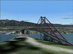
The default shorelines that come with Microsoft Flight Simulator 2004 are inaccurately placed. Consequently roads and other features are misplaced. Ultimate Terrain (R) from Flight One Software corrects this, however the Microsoft default objects are then misplaced. This software corrects the Lions Gate Bridge, Canada Place, Harbour Centre, Burrard Bridge, Science World and BC Place Stadium. Further it excludes a number of generic MS buildings that are now placed in False Creek. For developers, the XML code is included. Users may delete this file. Ultimate Terrain required. By Jon Patch
| Filename: | Vancouver_Default_Object_Corrections_for_Ultimate_.zip |
| License: | Check within download |
| Added: | 5th May 2010, 21:43:07 |
| Downloads: | 3,517 |
| Author: | Jon Patch |
| Size: | 288.76 KB |
| Category: Flight Simulator 2004 - Scenery | |
| Port Hardy CAW5 in British Columbia, Canada |
|
Images related to this file:
File Description:
This is the sixth in a series of new and renovated float bases in BC. Port Hardy CAW5 is in a sheltered inlet on the northeast coast of Vancouver Island, close to the town and just 6 miles northwest of the Port Hardy airport. There is fuel (both JetA and 100LL) and also oil available, and the base acts as a refuelling centre for the other float bases in the neighbourhood. The dock is one-sided as the northern side borders a shallow area that is in fact exposed at low tide, as is most of the inlet to the south of BC Packers (adjacent to the float base, to the south). The parking along the dock is maximised by backing up each plane by hand so that it is close to the one behind it; this is not possible to replicate with AI in FS9 (watch the video). Watch out for the log boom on the other side of the inlet, it is there to protect fish farm "pools". The AI involves several Beavers and Otters, as listed in the AI folder. At Port Hardy all the AI works for both landing and takeoff for all of the planes, no matter what is the wind direction. There is a pic of the Supplement Port Hardy page, showing the two take-off and landing areas plus the third area that is to be used for take-off before 7am. All of these float bases can be installed together in the same folders, with a saving in duplicate textures. So a series called BC Floats (or whatever you want to call it) or individually installed float bases; your choice. The next in the series was suposed to be Sullivan Bay, another floating marina, but I digressed to Port Hardy and Port McNeill (next to be posted). The two hotels by the nearby marina are included. One of them gave me weird problems and I gave up on achieving the correct shape.
| Filename: | Port_Hardy_CAW5_in_British_Columbia_Canada.zip |
| License: | Freeware, limited distribution |
| Added: | 19th January 2017, 15:01:45 |
| Downloads: | 200 |
| Author: | Roger Wensley |
| Size: | 8.27 MB |
| Category: Flight Simulator 2004 - Scenery | |
| LTFD - Edremit Korfez Airport |
|
File Description:
Edremit is a district in the coasts of Aegean Sea, linking to Balýkesir province, in the Marmara region of TURKEY.
Korfez Airport(LTFD) is located in between Kaz mountains and the gulf of Erdemit.
Edremit was founded in BC 1443 with the name of Adramyteion.Here was the most important settlement at that time.
Geographical characteristics of Edremit are determined by Kazdaðý
(Goose Mountain) which enclose the location in north direction.
The South part of Kazdaðý that commands the Gulf is ripped by innumerable deep valleys.The streams sourced from Kazdaðý give life to Edremit Gulf by passing canyons, flowing over waterfalls.
| Filename: | LTFD__Edremit_Korfez_Airport.zip |
| License: | Freeware |
| Added: | 22nd April 2008, 17:36:45 |
| Downloads: | 1,254 |
| Author: | Gökhan Bayrakdar |
| Size: | 7.19 MB |
| Category: Flight Simulator 2004 - Scenery | |
| Squamish CYSE replacement with AFCAD file |
|
File Description:
This is a replacement for my previous post, this time with the missing AFCAD file, and thanks to Richard for pointing this out. Squamish is around 40 miles north of Vancouver, at the top end of a BC fjord, past Bowen, Gambier, and Anvil Islands. There are 2,400 feet of asphalt runway 14/32, and watch out for the noise abatement procedures that either take you around the town on a much enlarged circuit and back to 14, or keep you away from the town with a slant final to 32, turning left 20 degrees when on short finals. There is no fuel.
| Filename: | Squamish_CYSE_replacement_with_AFCAD_file.zip |
| License: | Freeware |
| Added: | 12th January 2009, 12:11:08 |
| Downloads: | 651 |
| Author: | Roger Wensley |
| Size: | 3.62 MB |
| Category: Flight Simulator 2004 - Scenery | |
| The Victoria Falls of the Zambezi River, Zambia/Zimbabwe |
|
File Description:
One of the main landmarks of Africa, the spectacular Victoria Falls of the Zambezi River are missing in out-of-the-box FS. With a local SRTM LOD9 mesh as a base (included) and the help of satellite imagery, maps, Ground2K4, and GMax, we did our best to model a realistic representation of the falls, the river, and the gorge, complete with custom waterfall and spray effects. The portion of the Zambezi covered in this project extends from E25 to E26.5 (more than 100km), with the falls at its center. Also included is a replacement landclass file for an area of about 20km on either side of the Zambezi River and an optional AI boat (by Lynn and Bill Lyons) cruising on the Zambezi above the falls. Tested with FS2004 only but most scenery enhancements (not the AI boat) should work just as well in FS2002.
| Filename: | The_Victoria_Falls_of_the_Zambezi_River_ZambiaZimb.zip |
| License: | Freeware, limited distribution |
| Added: | 8th May 2004, 02:45:30 |
| Downloads: | 19,140 |
| Author: | Holger Sandmann and Johan van Wyk, Aeroworx |
| Size: | 3.5 MB |
| Category: Flight Simulator 2004 - Scenery | |
| Canadian Mountain Parks Pack |
|
File Description:
FS2004 Scenery - This file creates 12 new airports in six of Canada's National Parks (Banff, Jasper, Kootenay, Yoho, Glacier and Mt Revelstoke). Required is Holger Sandmann's excellent BC mesh, which is the reason for this file in the first place, and Lago's FSE demo file. Pack designed for low level visual 30 mile scenic flights with some tourist attraction additions (Takakkaw Falls, Emerald Lake, Lake Louise, Morainne Lake, Spiral Tunnel etc). The strips are ficticious, but the names and places are real. There is parking for you to add your own AI traffic as well. There are also improvements to other area strips (mainly lights and taxiways). Six flights included.
| Filename: | Canadian_Mountain_Parks_Pack.zip |
| License: | Freeware |
| Added: | 11th April 2004, 23:15:31 |
| Downloads: | 5,262 |
| Author: | Peter Vibe |
| Size: | 1.68 MB |
© 2001-2026 AVSIM Online
All Rights Reserved
Privacy Policy |