
Where Flight Simulation Enthusiasts Gather from Around the World!
AVSIM Library - Search Results

| Category: Flight Simulator 2004 - Scenery | |
| East Midlands Xtreme |

|
Images related to this file:
File Description:
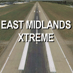
Extremely accurate scenery for East Midlands airport, UK. Includes night lighting, animation vehicles,High resolution photo base image, replacement AFCAD file, static and Museum aircraft. All textures
made to the highest standard based on actual photographs.
| Filename: | egnxx-fs9setupdemo.zip |
| License: | Commercial demo |
| Added: | 10th February 2012, 21:59:44 |
| Downloads: | 2,005 |
| Author: | Gary Summons/UK2000 Scenery |
| Size: | 77.83 MB |
| Category: Flight Simulator 2004 - Scenery | |
| Houston Downtown Scenery |
|
File Description:
Houston downtown scenery for FS2004.
Houston as it's never been seen before in FS!
Highly detailed, has 80+ custom-made buildings.
Replaces the default buildings and terrain.
Photo-realistic terrain is included.
Scenery features night lighting effects.
| Filename: | houston2010.zip |
| License: | Freeware |
| Added: | 10th June 2010, 00:44:47 |
| Downloads: | 1,729 |
| Author: | James Shaddox |
| Size: | 20.34 MB |
| Category: Flight Simulator 2004 - Scenery | |
| Timaru Airport |
|
File Description:
Richard Pearse Airport and South Canterbury Aero Club, Timaru, NZ.
The first release of phase 2 of the Godzone project, an attempt to add photo-realism to the New Zealand simming experience.
For use with FS2004 only!
| Filename: | timaru.zip |
| License: | Freeware, limited distribution |
| Added: | 14th March 2004, 17:44:10 |
| Downloads: | 4,255 |
| Author: | Robin Corn |
| Size: | 5.51 MB |
| Category: Flight Simulator 2004 - Scenery | |
| CJN4 Assiniboia Saskatchewan, Canada |
|
Images related to this file:
File Description:

Assiniboia Airport is located 11 km (7 miles) north of the town of Assiniboia in south central Saskatchewan, Canada. The airport is situated on the site of the wartime aerodrome built as part of the British Commonwealth Air Training Plan.
CJN4 Assiniboia was constructed using GMAX. It includes photo-real custom models of all the buildings at the airport, runway signs, refueling facilities, weather station, vehicles, runway and taxiway lighting and a rotating beacon. It also includes custom ground textures to replicate the crumbling decommissioned runways and cracked tarmac. The scenery replicates the pilot activated ARCAL lighting of airfield approach lights, edge lights, runway and taxiway lights.
| Filename: | cjn4_assiniboia_scenery.zip |
| License: | Freeware |
| Added: | 4th September 2010, 19:13:59 |
| Downloads: | 1,028 |
| Author: | Gregory Putz |
| Size: | 9.22 MB |
| Category: Flight Simulator 2004 - Scenery | |
| Cottonwood, AZ Photoreal |
|
File Description:
Photo scenery of Cottonwood, AZ based on 1992 USGS black & white aerial photos that have been colorized. The file includes full autogen, custom AFCAD and new generic buildings. Cottonwood is located in northern Arizona, just west of Sedona.
| Filename: | cottonwood.zip |
| License: | Freeware |
| Added: | 22nd December 2006, 12:31:44 |
| Downloads: | 1,447 |
| Author: | Kevin Burns |
| Size: | 6.36 MB |
| Category: Flight Simulator 2004 - Scenery | |
| Capitol Reef National Park/North - Hanksville (KHVE), Utah, Photo-Scenery |
|
Images related to this file:
File Description:
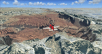
Capitol Reef National Park/North - Hanksville (KHVE), Utah, Photo-Scenery (for FS9 & FSX)
This scenery covers the northern part of Capitol Reef National Park, Hanksville (KHVE), the Goblin Valley and extends north to I70 and the San Rafael Swell. It extends my Canyonlands sceneries to the west and brings you another 3.500 sq km in 4.7m/pix quality. To explore the scenery depart from Hanksville (KHVE) and head northwest. High resolution versions of this scenery for FS9 and FSX (much sharper, but larger and multiple downloads) are available at www.blueskyscenery.com/CNY_West2.html . The screenies are taken from the high-res versions, so expect this version to be slightly more blurry. YourDonation@Work: Dedicated to Andy and Robert.
| Filename: | cny_west2_2010_lr.zip |
| License: | Freeware, limited distribution |
| Added: | 13th January 2010, 19:32:33 |
| Downloads: | 1,679 |
| Author: | Gottfried Razek, blueskyscenery.com |
| Size: | 94.77 MB |
| Category: Flight Simulator 2004 - Scenery | |
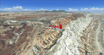
| Steamboat Springs (KSBS), Flat Tops Wilderness Area, Colorado - Photo-Scenery |
|
Images related to this file:
File Description:

Steamboat Springs (KSBS), Flat Tops Wilderness Area, Colorado, Photo-Scenery (FS9 & FSX)
The Flat Tops Wilderness Area, which is the second largest wilderness area in Colorado, is named for its many flat topped mountains that are clearly visible from the sky. Trappers Lake, located in the north of the area inspired Arthur Carhart, a US Forest Service official, to initiate a plea for Wilderness preservation as early as 1919. Finally in 1975, three years before his death in 1978, the Flat Tops were designated a wilderness area. No wonder he found the area so entrancing: Behind Trappers Lake loom majestic volcanic cliffs, and beyond them a vast subalpine terrain reluctantly yields to alpine tundra with an average elevation of about 10.000 feet. More than 100 lakes dot the country above and below numerous flat-topped cliffs. Steamboat Springs is an internationally known winter resort destination.
To explore the scenery depart from Steamboat Springs Airport (KSBS) or Yampa Valley Airport (KHDN) and head south. High resolution versions of this scenery for FS9 and FSX (much sharper, but larger and multiple downloads) are available at www.blueskyscenery.com/GNB_West2.html . The screenies are taken from the high-res versions, so expect this version to be slightly more blurry. Thanks to Joop Mak for providing custom AFCADs that correct airport layouts so that they align with the photo-textures! They are available at www.blueskyscenery.com/AFCADs.html . YourDonation@Work: Dedicated to James.
| Filename: | Steamboat_Springs_KSBS_Flat_Tops_Wilderness_Area_C.zip |
| License: | Freeware, limited distribution |
| Added: | 26th April 2010, 17:53:25 |
| Downloads: | 1,293 |
| Author: | Gottfried Razek - blueskyscenery.com |
| Size: | 91.57 MB |
| Category: Flight Simulator 2004 - Scenery | |
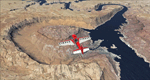
| Capitol Reef National Park/South - Waterpocket Fold, Utah, Photo-Scenery |
|
Images related to this file:
File Description:
Capitol Reef National Park/South - Waterpocket Fold, Utah, Photo-Scenery (for FS9 & FSX)
This scenery covers the area from the southern part of Capitol Reef National Park down along the Waterpocket Fold and the Henry Mountains. It extends my Canyonlands sceneries to the west and brings you another 3.500 sq km in 4.7m/pix quality. To explore the scenery depart from Hanksville (KHVE) and head northwest. High resolution versions of this scenery for FS9 and FSX (much sharper, but larger and multiple downloads)
are available at www.blueskyscenery.com/CNY_SouthWest2.html . The screenies are taken from the high-res versions, so expect this version to be slightly more blurry. YourDonation@Work: Eric and Andy.
| Filename: | cny_southwest2_2010_lr.zip |
| License: | Freeware, limited distribution |
| Added: | 13th January 2010, 20:46:53 |
| Downloads: | 1,716 |
| Author: | Gottfried Razek - blueskyscenery.com |
| Size: | 95.92 MB |
| Category: Flight Simulator 2004 - Scenery | |
| Lake Powell - Bullfrog Basin (U07), Utah, Photo-Scenery (FS9 & FSX) |
|
Images related to this file:
File Description:
This scenery covers the area from the southern end of the Waterpocket Fold down to the Bullfrog Basin and the eastern end of the Kiaparowits Plateau. It extends my Canyonlands sceneries to the southwest and brings you another 3.500 sq km in 4.7m/pix quality. To explore the scenery depart from Bullfrog Basin Airport (U07) and west. High resolution versions of this scenery for FS9 and FSX (much sharper, but larger and multiple downloads)
are available at www.blueskyscenery.com/CNY_South2West2.html . The screenies are taken from the high-res versions, so expect this version to be slightly more blurry. YourDonation@Work: Dedicated to Jean-Marc, Jim and Cay.
| Filename: | cny_south2west2_2010_lr.zip |
| License: | Freeware, limited distribution |
| Added: | 18th January 2010, 19:27:52 |
| Downloads: | 1,589 |
| Author: | Gottfried Razek - blueskyscenery.com |
| Size: | 92.83 MB |
| Category: Flight Simulator 2004 - Scenery | |
| Arches National Park, Moab (KCNY), Utah, Photo-Scenery (FSX too) |
|
File Description:
This scenery covers another beautiful National Park: Arches National Park near Moab in Utah. It contains the park itself, Moab, the La Sal Moutains and the northern part of Canyonlands National Park, which will be covered in an upcoming package. The total area is 3.500 sq km and comes in 4.7m/pix quality. To explore the scenery depart from Canyonlands Field Airport (KCNY) and head south. YourDonation@Work: Dedicated to Hector, William and Jerald. Thanks!
| Filename: | cny2009_lr.zip |
| License: | Freeware, limited distribution |
| Added: | 5th January 2009, 19:31:11 |
| Downloads: | 3,697 |
| Author: | Gottfried Razek - www.blueskyscenery.com |
| Size: | 94.68 MB |
© 2001-2025 AVSIM Online
All Rights Reserved