
Where Flight Simulation Enthusiasts Gather from Around the World!
AVSIM Library - Search Results

| Category: Flight Simulator 2004 - Scenery | |
| EKAH - Aarhus, Denmark v1.2 (2012) |

|
Images related to this file:
File Description:
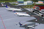
Expansion scenery for Aarhus airport at Tirstrup in Denmark.
Featuring detailed but low impact custom buildings for both civilian and military areas, custom apron polygons with accurate placement of gates and taxiways with two stage night lighting, drive through parking where applicable (AI aircraft do not push back from stands 1-4), custom vehicles and other objects.
This is version 1.2 only for FS9/2004 by UDSoft.
| Filename: | EKAH__Aarhus_Denmark_v12_2012.zip |
| License: | Freeware, limited distribution |
| Added: | 4th October 2012, 10:38:03 |
| Downloads: | 2,579 |
| Author: | Graham Heaven |
| Size: | 3.43 MB |
| Category: Flight Simulator 2004 - Scenery | |
| Kecskemét LHKE |
|
File Description:
LHKE Kecskemét Military Airport, Hungary. An active AFB 3nm from the city of Kecskemét. Most of the Hungarian Air Force Mig-29s are here,which ones hopfully 'll be replaced by SAAB JAS 39s. Not real-life buildings, but the RWY and TXWY routing is made from real map. I hope I could do the night lighting properly. Any comments,please write me. Good Flyn'!
| Filename: | Kecskemt_LHKE.zip |
| License: | Freeware, limited distribution |
| Added: | 2nd June 2004, 00:40:03 |
| Downloads: | 2,030 |
| Author: | Kornél Várhelyi |
| Size: | 3.83 MB |
| Category: Flight Simulator 2004 - Scenery | |
| Webster OFL (KNUI) for UT/USA |
|
File Description:
Webster Field is an outlying airport realted to PAX Naval Air Test Center in Maryland. According to what I have read, they use the airport mainly to test unmanned aircraft.
In a support note I saw an image of this airfield in Ultimate Terrain showing its runways extending out into the water. So I fixed it. I couldn't find much more info on it other than that on www.AirNav.com, so I've just kept the default layout for the most part. I did have to rotate the runways a bit to match the satellite photo about 10 degrees for 14/32. I kept the runway labels, however as that is how they are listed in Airnav and show up in the satellite photo. If anyone has any further info I'd be happy to add to it.
This version is meant for use with Ultimate Terrain USA.
| Filename: | Webster_OFL_KNUI_for_UTUSA.zip |
| License: | Freeware |
| Added: | 23rd February 2006, 05:20:49 |
| Downloads: | 377 |
| Author: | Thomas Perry |
| Size: | 218.88 KB |
| Category: Flight Simulator 2004 - Scenery | |
| Petaluma , California (O69) Scenery |
|
File Description:
This is a scenery upgrade for Petaluma Airport, California (O69). This is part Five of a series of small airstrip and minor airfield scenery enhancements which are based on real world data from Google Earth.
This is a more complex scenery than previous ones. You can see from the Google earth image that a golf course runs alongside the airport (appropriately called the Rabbit Run!). I have tried to include this with a golf course landclass polygon, also the airfield base seems mainly a red soil and this is reflected in the airbase poly. Built using EZ_Scenery, Lee Swordy's AFCAD and SBuilder. You must have rwy12 and EZ scenery libraries installed for the buildings to show. Both libraries of objects are free;
EZ Library is available from this URL http://www.abacuspub.com/pub/AbacusEZLibraries.exe
rwy12 from Avsim and additional EZ Custom libraries from Avsim. Search under Scenery design.
| Filename: | Petaluma__California_O69_Scenery.zip |
| License: | Freeware |
| Added: | 23rd March 2006, 23:09:07 |
| Downloads: | 719 |
| Author: | Kim Gowney |
| Size: | 629.87 KB |
| Category: Flight Simulator 2004 - Scenery | |
| Omni Aviation School and PhilipinesAirlines Flight Trianning Center AFCAD and Scenery |
|
File Description:
Manny Aquino for the acacia and acacia tree textures
OMNI AVIATION- www.omni-aviation.com
Tonet, Mike B and Pecorino for identifying the trees in front of the omni barracks and for identifying a missing taxiway. :-)
My cousin Spike Acenas for taking pictures of the airport.
Ina Patrimonio for taking some of the PFSGers up in an aerial tour around Clark last Feb 17 2002. :-)
Dennis T. for more OMNI pics.
Capt's: Ina Patrimonio, Joy Roa, Jessica Horne & Rene Mapua.
Installation:
Copy the OMNI folder to your FS2002/scenery/ folder and activate the scenery in FS2002.
Happy flying!
Clark Intl Airport AFCAD with Omni Aviation School and Philipines Airlines Flight Trianning Center.They also use Clark Tower to make Communication when their Aircraft wanna take off and landing. Its Pattern is on Right Hand Side at 700ft and their Parking Ramps are just for Cessna,Piper or Beech Craft!
| Filename: | Omni_Aviation_School_and_PhilipinesAirlines_Flight.zip |
| License: | Freeware |
| Added: | 15th November 2003, 05:28:34 |
| Downloads: | 962 |
| Author: | Peter Binamira(Scenery) and Cadmus Lee( AFCAD ) |
| Size: | 1.14 MB |
| Category: Flight Simulator 2004 - Scenery | |
| Mehrabad Ver 1.0 (Tehran-Iran) |
|
Images related to this file:
File Description:

.::PERSIAN-SIM::. This package contains a simple scenery of Mehrabad Intl Airport OIII (Tehran-IRAN) and its buildings, aprons and hangars. The aprons contain all civil ,military and others. The AFCAD file of the airport is designed and updated exactly using the latest changes of Mehrabad which includes the following changes: 1.The complete change of Taxiway names and Taxiway signs; 2.Additional west parking space with 10 parking positions (APRON 4); 3.TWY 13 has been eliminated; 4.Apron names have been changed; 5.The position of Fire Fighting Station is changed (a new station is built); 6.All Parking positions are changed in names and headings. This version of Mehrabad is fully freeware and is available only from PERSIAN-SIM and AVSIM Library. The PROFESSIONAL version of Mehrabad (Payware), including the realistic scenery, buildings, static aircrafts, and realistic dynamic scenery, will be available soon on www.PERSIAN-SIM.com.
| Filename: | Mehrabad_Ver_10_TehranIran.zip |
| License: | Freeware, limited distribution |
| Added: | 3rd November 2010, 23:26:41 |
| Downloads: | 1,644 |
| Author: | PERSIAN-SIM ::: Behnam Zamani |
| Size: | 5.12 MB |
| Category: Flight Simulator 2004 - Scenery | |
| Siofok Kiliti-Sagvar (LHSK) 2.0 |
|
File Description:
Freeware Scenery of Siófok Kiliti-Ságvár airport. This airport is used for general aviation, at Lake Balaton, has grass runway. Only for Flight simulator 2004. Changes and addons for version 2.0: Correct AFCAD from map, correct city placement, with VTP2 polygons. Roads, railways, Rivers, bridges and coastline position is now correct. Added Docks, detailed landclass with VTP2 polygons. Every centimeter of the detailed area now fits the sattelite photo. This scenery itself has a large addition to the default LHSK, which only has a runway. This addon has a correct afcad with taxiways and apron. Also added the ILS and PAPI for runway 33. This scenery was made for an aerobatic event on the IVAO network, so an aerobatic box is also added above Lake Balaton. You can remove this box at anytime via the instructions. Hope you enjoy this scenery and will have fun with it.
| Filename: | Siofok_KilitiSagvar_LHSK_20.zip |
| License: | Freeware, limited distribution |
| Added: | 11th March 2006, 16:45:04 |
| Downloads: | 1,530 |
| Author: | David Zoltan |
| Size: | 571.88 KB |
| Category: Flight Simulator 2004 - Scenery | |
| Homer PaHO in Alaska US |
|
Images related to this file:
File Description:
Homer is a mainly GA airfield with rows of open air parking, but it also has scheduled flights, a terminal building, a long (for GA) runway of just under 6,700 feet that is 150 feet wide and aligned 03-21 with VASI on both ends and ILS on 03. So I think we can refer to it as an airport. Plus, at the time of this scenery (around 2010) there were three newly completed hangars on the north apron that I was told were for three companies, Bald Mountain Air service, Maritime Helicopters, and Pathfinder Aviation. I do not know which was for whom, but all three companies are in the helicopter and/or plane charter business. The south apron has a number of hangars and other buildings along it's length, starting at the western end with Smokey Bay Air that has an old control tower on the roof, then the Fire Station, and then Homer Air. I am not aware of who owns what after those first three, except that at the far eastern end there are several garages etc for the airport maintenance equipment. Next to the airport at that end there are a number of boat maintenance companies with boats pulled out of the water; this could not be well replicated due to the airport elevation above the sea level and a misplaced road. The nearby Beluga Lake 5BL float base is also included here, with some AI. The lake height above sea level has been adjusted to cope with too many cliffs intruding into the water; this is an annoying FS9 habit. The Homer scenery is as close to the actual airport as I could make it, while coping with inaccurate coast lines and roads, and grassed areas that could not all be modified for reasons that I will not bore you with. The Spit is a major scenery feature next to the airport, and I have added to this to provide some boats, docks, and nearby buildings etc. Small planes use the adjacent gravel taxi path instead of the runway when back-tracking to take off on runway 21. They only go as far as the path takes them and then u-turn onto the runway and take off. By the way, this airport's AI will function at its best if the prevailing wind makes 03 the runway in use. And I will eventually stop writing 03 and just call it 3, as the US, alone in the world, does not put a zero in front of 01, 02, 03, 04 etc. Just one other thing to note is that all access to the runway is from taxiways A and B; there was (in 2010) no access to the extreme western end of the runway as the taxiway there is marked as out of service pending a needed resurfacing.
If you find an error email me please, and note that my email address has been changed to rogwens at Gmail dot com.
| Filename: | Homer_PaHO_in_Alaska_US.zip |
| License: | Freeware, limited distribution |
| Added: | 28th July 2021, 03:31:04 |
| Downloads: | 125 |
| Author: | Roger Wensley |
| Size: | 11.86 MB |
| Category: Flight Simulator 2004 - Scenery | |
| CYKF - Kitchener, Regional Muni of Waterloo - Ontario Canada |
|
Images related to this file:
File Description:
The town of Kitchener is in southern Ontario, 40 miles southwest of Toronto. The population is just over half a million, including the adjoining Cambridge and Waterloo which are known locally as the Tri Cities. The Kitchener name was adopted in 1916, replacing the former "City of Berlin".
The airport is on the northeastern side of the town, with the main runway aligned 08-26 and just over 7,000 feet of asphalt 150 feet wide, lit, with PAPI at both ends and approach lighting and ILS on 26. The second runway is aligned 14-32 and is 4,100 feet long, lit and with PAPI at both ends; right hand circuits for 32. The airport is being steadily enlarged and improved, with new hangars for rental, operators, and maintenance companies. The largest and most visible presence is the training operation located just off the southwest end of taxiway A, where there are 14 Cessna 172, 2 Cessna 152, 2 Piper Seminole, and others. These are represented in the AI. There are morning and evening scheduled flights by Westjet to Calgary and American Eagle to Chicago, also in the AI. To the southwest, past taxiway C, there is GA parking; request taxi to what is named here "southwest parking" where there are spaces on both grass and asphalt. To the southeast, along a taxiway off the southeast corner of the main apron, are mainly operators and maintenance facilities. This version of CYKF includes the new(ish) terminal, the first of the new central rental hangars alongside the new taxiway and access road, and the very new large hangar off taxiway C, but not the new airport services building (fire and snow clearance) that is off to the southeast of taxiway A, and not the new car park to the south of the airport access road. So an uncertain and possibly historically innacurate date, but with the correct taxiway lighting and signage, and building textures from photographs.
| Filename: | CYKF__Kitchener_Regional_Muni_of_Waterloo__Ontario.zip |
| License: | Freeware, limited distribution |
| Added: | 7th May 2016, 21:13:28 |
| Downloads: | 547 |
| Author: | Roger Wensley |
| Size: | 28.69 MB |
| Category: Flight Simulator 2004 - Scenery | |
| VFR of Lario - Como lake, Italy |
|
Images related to this file:
File Description:
This is the first of the expected seventeen sceneries in the "VFR of Lario" project, that will include the full view of the Como Lake, made with photorealistic terrain (multiseason & night) and with 3D GMax realistic objects, including some motions. Further the Como seaplane airport, the project will include some other virtual ones, and all the piers of NLC (Navigation Lake Como). The project will be completed with a related AI seaplane traffic.
The "VFR of Lario" project REQUEST the installation of the scenery "Itcoast2.zip" & the related "ITAC2_P1.zip", both available for free download from different libraries.
Information: Como is the main and beautifull city on the namesake lake (called Lario), placed in the north of Italy, closed to the Helvetic border. It includes the AeroClub Como seaplanes international airport, with his own flight school. Como has the headseat of NLC, the fleet management for connection of forty Lario's piers. This first scenery covers approximately an area of 7.5x6 kmt.
Contents: airport water track with hangar and static seaplanes; breackwater and stadium lake front, war memorial monument, Volta's temple and lighthouse, main Cathedral, Social theater, city old towers and wall, villa Olmo, square Cavour's buildings, NLC main pier and some minor others, Como-Brunate's funicolar connection (animated), lake fountain, Tavernola shipyard, Baradello's castle, Valduce hospital; motor ships (animated), steamer, hydrofoils and other minor boats; several other buildings (GenericBuilding system), trees and lights widespread all over the scenery.
| Filename: | VFR_of_Lario__Como_lake_Italy.zip |
| License: | Freeware |
| Added: | 22nd December 2011, 23:30:47 |
| Downloads: | 3,549 |
| Author: | Aldo Della Vedova, Daniele Lanfranchi, Diego Caligiuri |
| Size: | 25.33 MB |
© 2001-2026 AVSIM Online
All Rights Reserved
Privacy Policy |