
Where Flight Simulation Enthusiasts Gather from Around the World!
AVSIM Library - Search Results

| Category: Flight Simulator 2004 - Scenery | |
| Alma CYTF in Quebec Canada |

|
Images related to this file:
File Description:
This is the second of five sceneries around Lac Saint-Jean in Quebec, Canada. Alma, the town, is 7 miles east of Lac Saint-Jean, on both the northern and southern banks of the Saguenay River. The airfield is at the southern edge of the town, with a single 13-31 runway 5,000 feet long and approach lighting at both ends. There is a visible ILS sytem but this was no longer in operation by 2010, the approximate date setting of this scenery. The largest operation on the field, by far, is Panorama Helicopters (actually Helicopteres Panorama) and this is reflected in the AI and a parked static helicopter. The ai includes helicopters that were originally posted as part of the payware Alaska Fjords series, with the permission of FSAddon. There are also other planes listed that will be required here or for the future posts in this series and are included here. The amphibious Beaver AI plane will only be available if you already have the payware Aerosoft Beaver installed, and I should have made it clear that the float Beaver included in the CTD3 AI was also an Aerosoft plane.
| Filename: | Alma_CYTF_in_Quebec_Canada.zip |
| License: | Freeware, limited distribution |
| Added: | 6th November 2017, 19:30:34 |
| Downloads: | 226 |
| Author: | Roger Wensley |
| Size: | 17.42 MB |
| Category: Flight Simulator 2004 - Scenery | |
| Mackenzie River close to Tulita CZFN in Northwest Territories Canada |
|
Images related to this file:
File Description:
I discovered, while testing another airfield near the Mackenzie River, that along the side of the Mackenzie adjacent to Tulita, and for a considerable distance, there was a cliff of water. I have no idea if my version of Ultimate Terrain has developed a fault or if this has been caused by the installation of a terrain mesh that now argues with UT for some unknown reason. Whatever, it was impossible to leave it as it was. I have included a screenshot of the cliff further upstream. To avoid the cliff of water I have flattened that area of the Mackenzie River and the adjacent river banks and both the town and the airfield to a height above sea level of 400 feet. This does not reflect the real life situation but is the lesser of two optical evils. I have included a screenshot of the flattened area. If you do not have a problem then you do not need this. If you too have a cliff of water then you might want to try this. It does not completely get rid of the problem, but it does get rid of it in the area visible when landing or taking off at Tulita.
| Filename: | Mackenzie_River_close_to_Tulita_CZFN_in_Northwest_.zip |
| License: | Freeware, limited distribution |
| Added: | 1st August 2021, 22:27:01 |
| Downloads: | 74 |
| Author: | Roger Wensley |
| Size: | 573.48 KB |
| Category: Flight Simulator 2004 - Scenery | |
| St Lawrence Island AK: Gambell PAGM, Savoonga PASA, and Northeast Cape |
|
Images related to this file:
File Description:
St Lawrence Island is in Alaska, but "in" is slightly misleading as it is in fact in the Barents Sea and 120 miles from the Alaska mainland, and only 40 miles offshore of Russia. The island is around 100 miles long, with two villages and at the eastern end an old air force radar base that was cleared away some 25 years ago. Gambell is one of the two villages and is at the far western end of the island, with a population of around 700 living mainly from the sea. This northern airfield is unusual in that it has an asphalt runway and apron, the lit runway being aligned 16-34 and just over 4,500 feet long. The reason for the asphalt becomes apparent if you try walking in the vicinity, as underfoot there are rounded pebbles down to varying depths, and they are quite small and eventually slippery enough to trip you up. To base a flexible gravel runway on top of this would have been difficult, and when it was originally built it was for an air force base (closed long ago). The village is also fairly unique among northern settlements in that it has wind turbines and also solar panels. The second village is Savoonga and is around 40 miles east of Gambell with a similar population. The runway here is lit gravel aligned 5-23 and 4,900 feet long. This village also has wind turbines and solar panels. There are no vehicles (cars, pickups, trucks etc) on the island, mainly because there is nowhere far to go to and in the case of Gambell because roads as such would be difficult to create. ATV's are the standard way to go, along with small boats for fishing and whaling. At the eastern and of the island the remaining traces of the air force radar base are just the gravel runway and aprons, included with the Savoonga scenery. The AI included here is for daily flights from Nome by ERA and Bering Air, along with some GA. Also included here is the EZ library that includes the wind turbines, to save you looking for it. Installing this will also mean that a wind farm in my Cyprus scenery wii now be visible to the north of Larnaca, and there are other libraries in the series that include useful objects. The Lens_EZ_Animated library could go into your static objects folders, which is where I have it; up to you.
| Filename: | St_Lawrence_Island_AK_Gambell_PAGM_Savoonga_PASA_a.zip |
| License: | Freeware, limited distribution |
| Added: | 29th February 2020, 00:09:36 |
| Downloads: | 221 |
| Author: | Roger Wensley |
| Size: | 11.59 MB |
| Category: Flight Simulator 2004 - Scenery | |
| Qikiqtarjuaq CYVM (Broughton) and DEW FOX-5 in Nunavut, Canada |
|
Images related to this file:
File Description:
Qikiqtarjuaq is an airfield on the northeast coast of Baffin Island, just over 100 miles north of Pangnirtung. The airfield is the closest Canadian airfield to Greenland and is used for ferry flights from Canada to Europe for small planes, though there is normally only JetA1 fuel available. The airfield is at only 18 feet ASL next to the sea with the village to the north; it was previously (before 1998) called Broughton Island. The runway is 3,800' of 100' wide gravel and is lighted; as it is in the Northern Domestic Airspace the runway is signed as 033T-213T, using "true" bearings instead of magnetic. There is a terminal and a small maintenance building on the apron and these have been modeled specifically for this scenery. There are AI parking spots; the AI visiting aircraft are a Canadian North Dash 8 and a First Air 42-300. Qikiqtarjuaq village is just north of the airfield and has a population of around 520; it is approximately the right size and shape but no buildings were specifically modeled for the village. There is also a North Warning System site called Fox-5 to the northeast, and this too is included. You will need Ultimate Terrain Alaska Canada.
| Filename: | Qikiqtarjuaq_CYVM_Broughton_and_DEW_FOX5_in_Nunavu.zip |
| License: | Freeware, limited distribution |
| Added: | 14th June 2011, 02:04:26 |
| Downloads: | 555 |
| Author: | Roger Wensley |
| Size: | 1.85 MB |
| Category: Flight Simulator 2004 - Scenery | |
| Komakuk Beach & Storm Hills DEW sites in Yukon and Northwest Territories, Canada |
|
Images related to this file:
File Description:
These are DEW line sites in northern mainland Canada, to the west of Tuktoyaktuk.
Komakuk Beach CWKB is not included in FS9 and is in the Yukon, only 20 miles from the Alaska border. It is, as the name suggests, close to the sea, and the gravel runway 3,600' by 125' has its western end almost on the beach.
There is no lighting and no signage and the airfield is officially listed as closed, but in fact is used during the annual maintenance and refuelling of the automated NWS (North Warning Station) close by and for any unscheduled servicing. This replaced the previous much older DEW station that was manned year round and had a lot more buildings.
Storm Hills CWSH is in the Northwest Territories, 43 miles south-southwest of Tuktoyaktuk, up on higher land at 810 feet ASL. The NWS (there was no previous DEW station at this site) is serviced by helicopter from Tuktoyaktuk and has a gravel landing pad on the north side of the station. It will show on a gps and it is 5 miles west of the distinctively shaped and large Parsons Lake. This too was not in FS9.
| Filename: | Komakuk_Beach__Storm_Hills_DEW_sites_in_Yukon_and_.zip |
| License: | Freeware, limited distribution |
| Added: | 16th July 2012, 18:56:09 |
| Downloads: | 304 |
| Author: | Roger Wensley |
| Size: | 1.68 MB |
| Category: Flight Simulator 2004 - Scenery | |
| Exploring Our World - Part 2 - Easter Island, Chile - SCIP - a complete makover. |
|
File Description:
Exploring Our World - Part 2 - Easter Island, Chile. In part two of this new series you will find a complete makeover of Easter Island which MS virtually ignored. Designed to compliment the fine Mataveri International Airport by Daniel Rojas (scip_o7.zip at Flightsim.com), this package includes Mesh and adjusted coastlines by John Young. John has also provided a new Afcad which removes unrealistic pushback starts. A new landclass file by John Burford adds the villages near the airport and more realistic ground treatments. You will also find numerous scenery enhancements using objects from the RWY12 and EZ Scenery libraries. Francisco Vargas has contributed a set of Thermals which soaring fans will enjoy. Of special interest is the use of AI Volkswagens, as taxi's driving around the airport and AI Helicopters that take visiting tourists on sightseeing tours. The AI Volkswagens have been provided by Ranier Girbig and are used with his permission. Easter Island, home of the mysterious head statues (Moai) has many new and exciting things just waiting for you to explore. Even the small adjacent Moto Nui Island, which MS forgot, has been added. This is the second of a series exploring lesser known parts of our FS world. Please unzip (using folders option) to a temporary folder and follow the documentation very carefully to assure a proper installation. ......
| Filename: | Exploring_Our_World__Part_2__Easter_Island_Chile__.zip |
| License: | Freeware |
| Added: | 13th July 2006, 03:22:45 |
| Downloads: | 6,691 |
| Author: | David "Opa" Marshall and friends |
| Size: | 6.7 MB |
| Category: Flight Simulator 2004 - Scenery | |
| Airstrips of Central Germany |
|
Images related to this file:
File Description:

Another selection in my Airstrips of Western Europe project, herewith 80+ small airfields in central Germany, each enhanced with taxiways, parking spaces, buildings etc. and aprons as appropriate, to further facilitate the generation of lightweight AI traffic in the area, without overloading the more major airfields.
Again, there's no photo-realism here, just a selection of basic 'generic' buildings, more or less accurately sized and placed to reflect the airfield layout as seen on on-line satellite imagery and aerial photography. These buildings have minimal effect on frame-rates, so are ideal for this kind of job. The airfields are aligned as well as possible with the roads etc. in UT Europe and the Genesis Europe mesh, but should mostly be fine in a default installation or other configuration.
As before, the files for each airfield can be easily identified by the ICAO code, even if the airfield names vary slightly, so you can pick and choose and mix and match to suit any sceneries you already have, should you so wish. There is no requirement for any other download. Each airfield will exist as a stand-alone entity should you only want a few of them.
Please read the rest of this "blurb" in the included text file. There may be some details of note or interest.
| Filename: | Airstrips_of_Central_Germany.zip |
| License: | Freeware |
| Added: | 26th February 2025, 19:22:06 |
| Downloads: | 108 |
| Author: | Chris Eve |
| Size: | 1.14 MB |
| Category: Flight Simulator 2004 - Scenery | |
| Union Island TVSU in the Grenadines, eastern Caribbean Version 1.1 |
|
Images related to this file:
File Description:
This is a self-contained version 1.1 that modifies the terrain flattens around the airport. I found that suddenly, and for no apparent reason, the Lesser Antilles mesh and my flattens were at war and creating hills within the airport boundary. If you are not having problems then you do not need this.
Union Island is in the southern tail of the chain of islands known as St Vincent and the Grenadines, between Canouan and Carriacou. Union is another small island, 3.5 miles long and at its widest 1.5 miles wide; the resident population is around 3,000, mostly in the two towns Clifton and Ashton. The airport is at the eastern end of the island, and has been extended into the sea on landfill. The runway is now around 2,480 feet long, aligned 08 (and with the southeast trade winds it is unlikely that you will find yourself using 26) and with a displaced threshold of 530 feet due to the hill to the west. The terminal is adjacent to a rather small apron; there is parking on the grass north of the taxiway. There are connecting flights by SVG to Barbados and the other islands and these are reflected in the AI. The airport has no lighting, and flights are obliged to land and depart in daylight hours only, outside of which the airport is closed.
| Filename: | Union_Island_TVSU_in_the_Grenadines_eastern_Caribb.zip |
| License: | Freeware, limited distribution |
| Added: | 16th June 2013, 18:46:33 |
| Downloads: | 526 |
| Author: | Roger Wensley |
| Size: | 2.02 MB |
| Category: Flight Simulator 2004 - Scenery | |
| LFRD2004 Dinard/St-Malo VFR Scenery |
|
Images related to this file:
File Description:
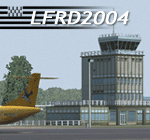
LFRD is a regional airport in Brittany, France. This scenery was created entirely with GMax and the latest Microsoft compilers. Everything was made to ensure maximum framerate while giving maximum visual impact, even on humbler machines. This scenery will run just as fast as the default one (which is very bare) with your current settings, even though there are literally thousands of houses, buildings, trees and a detailed airport.
This is a complete package:
-SRTM local mesh with custom coast trimming
-Custom phototexture (200sq km), with seamless blending into FS9 standard landclass
-Full autogen with custom local texture
-Custom landclass and waterclass
-AFCAD2 file with parking codes
-Custom Hi-res photographic textures at airport.
-Gmax buildings and xml librairy objects.
It was made by a real life pilot and is totally aimed at recreating the feeling of being there, not so much on the ground (after all, this is a FLIGHT simulator), but at circuit altitudes. This is not about recreating an airport in all its glorious details at the cost of framerate, but instead an exercise in balancing visual cues and details as viewed from up there to make it 'as real as it gets' within the limits of FS9. Scenery made by Vauchez (http://mapage.noos.fr/euro_vauchez/)
| Filename: | LFRD2004_DinardStMalo_VFR_Scenery.zip |
| License: | Freeware, limited distribution |
| Added: | 28th April 2010, 18:06:05 |
| Downloads: | 46,559 |
| Author: | Etienne Vauchez |
| Size: | 10.55 MB |
| Category: Flight Simulator 2004 - Scenery | |
| CYOC - Old Crow - Yukon Territory, Canada |
|
Images related to this file:
File Description:
Old Crow is in the far north of the Yukon Territory, Canada, 115 miles south of the nearest coastline and 30 miles east of the border with Alaska. The town has a population of less than 300 and the population are reliant on the caribou migration for an annual food supply replenishment. The fact that it is the only Yukon town that cannot be reached by car makes the airport important, and there are regular flights by Air North, the Yukon airline. They are included in the AI along with GA aircraft. I had several tries at matching up the Hawker Siddeley 748 with the right set of textures and I have included both here so that you do not have to go through the same torture. Thanks go to Hernan for sorting all that out, and for his textures. The airport is beside the town that is built along a bank of the Porcupine River. I have replicated the current shore line of the river that has cut a new channel at one end of the town, and I flattened the river as it was somewhat mountainous. The runway is gravel and just over 5,000 feet long, aligned 03-21. The terminal building is specific to Old Crow as I had photos, but the hangars are approximations and the village houses are only representational.
| Filename: | CYOC__Old_Crow__Yukon_Territory_Canada.zip |
| License: | Freeware, limited distribution |
| Added: | 5th December 2014, 13:31:46 |
| Downloads: | 370 |
| Author: | Roger Wensley |
| Size: | 7.58 MB |
© 2001-2026 AVSIM Online
All Rights Reserved
Privacy Policy |