
Where Flight Simulation Enthusiasts Gather from Around the World!
AVSIM Library - Search Results

| Category: Flight Simulator 2004 - Scenery | |
| Albian CAL4, Firebag CFG6, Horizon CYNR, Mildred Lake CER4, and Muskeg Tower CFW4 in Alberta Canada |

|
Images related to this file:
File Description:
All of these airfields are in or close to the Athabasca Tar Sands in Alberta, modelled here along with the airfields. The tar sands workings extend along the Athabasca River for over 60 miles north of Fort McMurray in northern Alberta, and the huge cleared areas, surface mining, tailings ponds, and refineries along the Athabasca are right up there as Alberta's biggest VFR landmark. One look at a tailings pond (sea? ocean?) makes it clear that someone was worried about public reaction to the size. As well as the surface mining there are also large areas where there is underground extraction with a grid of dirt tracks between equipment installations. There are four airfields associated with the tar sands. Horizon CYNR is a public service airport operated by Canadian Natural Reources Ltd. Mildred Lake CER4 is owned and operated by Syncrude. Albian CAL4 is owned and operated by Shell Canada, and Firebag CFG6 is owned and operated by Suncor Energy. The fifth airfield is the nearby Muskeg Tower CFW4, which is there solely to support folks during their fire watch in the 120 feet tall tower. There is also a sixth airfield east of Horizon across the river and still visible, Bitumount; this is no longer in use. There is Ai included involving Canadian North, North Cariboo, Wasaya, HTS, First Air, Suncor, etc.
| Filename: | Albian_CAL4_Firebag_CFG6_Horizon_CYNR_Mildred_Lake.zip |
| License: | Freeware, limited distribution |
| Added: | 4th October 2013, 22:12:42 |
| Downloads: | 935 |
| Author: | Roger Wensley |
| Size: | 16.75 MB |
| Category: Flight Simulator 2004 - Scenery | |
| Mackenzie CYZY in British Columbia, Canada |
|
Images related to this file:
File Description:
Mackenzie is around 120 miles west of Peace River and the BC/Alberta border, at the southern end of Williston Lake. The lake is 135 miles long and the population of the town is about 3,500; those figures illustrate typical Canada, a huge area enjoyed by the few. The main occupations relate to timber and mining in some form, plus tourism (in particular winter sports tourism). The airport is 2 miles southwest of the town, with no regular scheduled flights but it is not unusual to find Central Mountain Air there delivering either charter passengers or freight. The single runway is aligned 16-34 and 100 feet wide lit asphalt that is just over 5,000 feet long, with (in 2010 or so) an additional 1,500 feet of gravel. There is PAPI at both ends of the asphalt. The largest operation based at the airfield is a helicopter company, at the northern end of the apron. There is a "mandatory frequency" of 123.5 which is a Canadian invention; you MUST have a radio. There is no control tower at the actual airfield, and if or when there is no response from further afield then you announce your intentions etc. In FS9 there is no way to "switch off or on" the monitoring of a MF radio frequency so you will find that this one is always silent.
| Filename: | Mackenzie_CYZY_in_British_Columbia_Canada.zip |
| License: | Freeware, limited distribution |
| Added: | 27th December 2018, 20:19:05 |
| Downloads: | 132 |
| Author: | Roger Wensley |
| Size: | 19.81 MB |
| Category: Flight Simulator 2004 - Scenery | |
| Chignik Lake A79 and Port Heiden PAPH - Alaska, USA |
|
Images related to this file:
File Description:
These are two villages in Alaska, in the peninsula that is the start of the Aleutians. Both are east of Perryville, Chignik Lake by 30 miles on the south side of the peninsula and Port Heiden by 75 miles on the north coast. Both are served by Grant Aviation government-subsidised regional flights from King Salmon. Chignik Lake has a population of around 70. There are two buildings on the airfield, but passengers still wait in their car for the plane to arrive as there is no terminal building as such. The runway is 3,300 feet of gravel aligned 08-26, as are so many in this area. Port Heiden is on the north shore of the peninsula, and the population is around 100. FS9 showed the town as being large enough to house 10,000; the new landclass here reduces this to the actual 40 or so houses, one and a half miles south of the airport. The roads are still the FS9 originals, which are approximately in the right place but are brightly lit at night as I was too lazy. The main occupation is fishing. There are buildings on the airfield (mostly old, except for a garage building) but passengers again wait in their cars for the plane to arrive. The two runways are both gravel, and are 05-23 of 6,200 feet, and 13-31 of 4,400 feet.
| Filename: | Chignik_Lake_A79_and_Port_Heiden_PAPH__Alaska_USA.zip |
| License: | Freeware, limited distribution |
| Added: | 30th March 2015, 20:28:47 |
| Downloads: | 292 |
| Author: | Roger Wensley |
| Size: | 5.1 MB |
| Category: Flight Simulator 2004 - Scenery | |
| Bethel PABE in southwest Alaska |
|
Images related to this file:
File Description:
There are four main northwestern Alaska towns which have good airports and are serviced by Alaska Airlines. From these airports local flights connect to nearby villages, "nearby" in Alaska meaning up to 200 miles away. The northernmost is Barrow. Southwest of Barrow is Kotzebue, then Nome, and the furthest south is this one, Bethel. The town of Bethel has a population of just over 6,000 and is 50 miles from the sea on the Kuskowim River, that splits and forks into many tributaries. Bethel Airport is close to the town and provides the only contact with the rest of Alaska, as there is no connecting highway system. There are scheduled flights by Alaska Airlines, ERA (now called Ravn) and Grant Aviation, plus others such as Ryan Air. There are cargo flights by Everts, Northern, and Lynden, and redistribution onwards to nearby villages by the smaller locally-based planes; all of these are included in the AI. There are two main runways, one just under 6,400 feet and another just under 3,900 feet, both of them aligned 19-1. The third runway is around 1,800 feet and mainly gravel, aligned 11-29. Parking at PABE is on three aprons, the northern for smaller commercial planes of Grant, ERA, Ryan etc, the central for larger planes of Alaska, Northern, Everts, and Lynden, and the southern for a large collection of GA; each apron has further hangars for maintenance companies and smaller operators. There is also another separate apron for the local military and Coastguard. There is not much photographic information available for PABE, and I have never been there; as a result it was impossible to make detailed photographic textures for some of the buildings. However, for most hangars I have made textures of at least the right colour etc based on the information I assembled and if it is green with white trim and side windows then that is how it now appears here. The exceptions are the Alaska Airlines terminal building which has complicated curved elements, and the two military hangars and workshops where I had to settle for an Alaska terminal building from another airport and the same for the military. There are numerous small villages in the vicinity of Bethel, all of them being beside either a river tributary or the coast. There are two Google Earth screenshots to show the villages that are served by the flights from Bethel and that are (mostly) included in the AI. Some of these airfields were not included in FS9 but AI will still operate in and out of Bethel. The smaller area screenshot shows the villages that are close to Bethel, and of these eight I have so far made six and they are included in this post: Napaskiak PKA, Napakiak WNA, Kwethluk KWT, Atmautluak 4A2, Nunapitchuk 16A, and Kasigluk Z09. I will work my way through the rest of the area.
| Filename: | Bethel_PABE_in_southwest_Alaska.zip |
| License: | Freeware, limited distribution |
| Added: | 8th March 2019, 00:37:58 |
| Downloads: | 303 |
| Author: | Roger Wensley |
| Size: | 32.02 MB |
| Category: Flight Simulator 2004 - Scenery | |
| Sioux Lookout CYXL in northern Ontario, Canada, updated |
|
Images related to this file:
File Description:
This greatly modifies my previous post of Sioux Lookout; it is stand-alone and does not require you to have the 2009 version. The AI provided with the post complements what was included with Dryden (March 2013). Sioux Lookout is in northern Ontario, 40 miles east of Dryden, and 145 miles northwest of Thunder Bay. The town is on the northeastern shore of a lake that I don't know the name of (I've been there, but has anyone COUNTED how many lakes Canada has?). It has a population of around 5,000. The main businesses are lumber, tourism, and health care. The airport is immediately adjacent to the northeastern corner of the town, and has 5,300' of asphalt which is aligned 16-34. There are two taxiways which curve and climb up to the apron which is 20 or 30 feet higher. When you taxi on them the knowledge that in reality you would be climbing makes sense of the curved routing. The apron is large and a mixture of asphalt and gravel. I did not make the terminal building and I have no photo or even a recollection of what it looks like, so you should first install Northwest Ontario Airports by Eric O'Link as he has a terminal building for CYXL that might be how it looks; some of his airfields collide with other and newer versions and I have kept only his CYXL and CYPL bgl's.
| Filename: | Sioux_Lookout_CYXL_in_northern_Ontario_Canada_upda.zip |
| License: | Freeware, limited distribution |
| Added: | 19th March 2013, 19:23:24 |
| Downloads: | 405 |
| Author: | Roger Wensley |
| Size: | 5.08 MB |
| Category: Flight Simulator 2004 - Scenery | |
| CYVP - Kuujjuaq - Quebec, Canada |
|
Images related to this file:
File Description:
Kuujjuaq is in northern Quebec at the southern end of Ungava Bay, and 30 miles up the Koksoak River. Kuujjuaq has a population of around 2,400; it was previously called Fort Chimo and in 1830 there was a Hudson Bay trading post established close by, but on the other bank of the river. A nursing station and a school were established in 1948 and the Hudson Bay post moved across the river to the current location. The airport is to the south of the town and, unusally for northern airfields, has two runways. The asphalt runway is 6,000 feet long and aligned 07/25, and the gravel runway is 5,000 feet long and aligned 13/31; 07 has ILS. There is fuel available, both 100LL and JetA, but the 100LL will be in drums and you are required to have your own pump. There are numerous flights that stop at Kuujjuaq; the AI included here has Air Creebec, First Air, Wasaya Airways, and Air Inuit (Kuujjuaq is a maintenance centre for Air Inuit) plus private flights by various aircraft. There is also a flight by my poor representation of a Helicopter Transport Services chopper. There is a float base on the nearby Stewart Lake during the summer months. The base is within the Kuujjuaq control zone, and normally you would talk to the tower and inform them of your intentions, but in FS9 this cannot be replicated.
| Filename: | CYVP__Kuujjuaq__Quebec_Canada.zip |
| License: | Freeware, limited distribution |
| Added: | 11th February 2013, 06:22:50 |
| Downloads: | 812 |
| Author: | Roger Wensley |
| Size: | 5.92 MB |
| Category: Flight Simulator 2004 - Scenery | |
| Mesa Verde National Park, Cortez (KCEZ), Colorado, Photo-Scenery (FS9 & FSX) |
|
Images related to this file:
File Description:
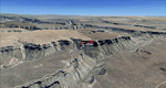
Mesa Verde National Park is famed for its numerous ruins of cliff dwellings built in the 12th century by ancient Pueblo people called Anasazi. Cliff dwellings are highly defensible stone villages situated under alcoves (rock overhangs) along the canyon walls. The largest cliff dwelling in the park is Cliff Palace, which is the largest cliff dwelling in North America. Cliff Palace contained 150 rooms and housed approximately 100 people. Unfortunately you won't see the cliff dwellings from the air, because they are under the cliffs but you will see everything else like all roads, trails and facilities. Very little is known about the Anasazis and the reason for their sudden departure at the end of the 13th century remains a mystery. Theories range from crop failures due to droughts to an intrusion of foreign tribes from the North. The name "Mesa Verde" stems from Spanish explorers seeking for a route from Sante Fe to California. They named the region Mesa Verde (spanish for green table) because of its high, tree-covered plateaus. High resolution versions of this scenery for FS9 and FSX (much sharper, but larger and multiple downloads)
are available at www.blueskyscenery.com/GNB_West2.html . The screenies are taken from the high-res versions, so expect this version to be slightly more blurry. Thanks to Joop Mak for providing custom AFCADs that correct airport layouts so that they align with the photo-textures! They are available at www.blueskyscenery.com/AFCADs.html . YourDonation@Work: Dedicated to David.
| Filename: | Mesa_Verde_National_Park_Cortez_KCEZ_Colorado_Phot.zip |
| License: | Freeware, limited distribution |
| Added: | 1st May 2010, 03:55:31 |
| Downloads: | 1,467 |
| Author: | Gottfried Razek - blueskyscenery.com |
| Size: | 92.87 MB |
| Category: Flight Simulator 2004 - Scenery | |
| Aspen (KASE), Colorado, Photo-Scenery (FS9 & FSX) |
|
Images related to this file:
File Description:
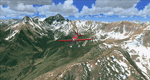
There sure is more than one reason to go to Aspen and this is sure another must-have of my Colorado sceneries. If you're coming IFR there's a couple of very demanding approach procedures. From a LOC/DME to several visual approaches there's everything your heart might desire. Due to the steep and high surrounding terrain these are quiet some hair raisers (see www.airnav.com/airport/KASE). If you're coming VFR then the traffic pattern altitude is 9.005 ft for light aircraft (vs. 9.505 for aircraft 12.500 lbs or more). Weather and wind permitting, RW15 is preferred for all landings (left pattern). RW33 has a right pattern and is preferred for all takeoffs. You even need a written permission to depart RW15. When departing VFR make a right turn to a heading of 360 degrees ASAP for noise abatement and hold this heading for at least 2 miles from the field. And don't forget to enjoy the impressive mountain scenery with two 14ers: Snowmass Mtn. and Castle Pk. to the southwest. This scenery brings you another 3.500 sq km of beautiful Colorado in 4.7m/pix quality. High resolution versions of this scenery for FS9 and FSX (much sharper, but larger and multiple downloads) are available at www.blueskyscenery.com/GNB_South2West2.html . The screenies are taken from the high-res versions, so expect this version to be slightly more blurry. YourDonation@Work: Dedicated to Mark, Markus and Yves.
| Filename: | Aspen_KASE_Colorado_PhotoScenery_FS9__FSX.zip |
| License: | Freeware, limited distribution |
| Added: | 30th January 2010, 17:04:55 |
| Downloads: | 3,578 |
| Author: | Gottfried Razek - blueskyscenery.com |
| Size: | 92.5 MB |
| Category: Flight Simulator 2004 - Scenery | |
| Squamish CYSE in British Columbia Canada |
|
Images related to this file:
File Description:
Squamish is a town with a population of just under 20,000, located at the northern end of Howe Sound where the Squamish River reaches the sea. Howe Sound is 25 miles deep and around 10 miles northwest of downtown Vancouver. It was for years based on the surrounding timber and a pulp mill, but with the closure of the saw and pulp mills now is more tourist oriented and the escape for Vancouver residents looking for (relative) peace and quiet. The runway is 2,400 feet of asphalt aligned 14-32. The buildings are built on differing levels of terrain, and the taxiways are sloped access ramps between the levels. This, of course, cannot be replicated in FS9, but it explains what at first sight appears to be a strange layout. The buildings are fairly well replicated. This is not an airport, it is an airfield meant for summer use as there is no lighting of any sort for runway or taxiways. The AI includes both GA and the helicopter flights by the two companies with bases at Squamish, Black Tusk and Blackcomb, the latter having several bases in this area with a HQ in Whistler. If you have the Vancouver scenery by FSAddon then you will need to move some of their bgl's aside; there are screenshots so that you can see which ones I have relocated. The UT settings are optional; I have been asked for my personal preferences. If you find a defect, email me.
| Filename: | Squamish_CYSE_in_British_Columbia_Canada.zip |
| License: | Freeware, limited distribution |
| Added: | 16th November 2020, 19:15:12 |
| Downloads: | 125 |
| Author: | Roger Wensley |
| Size: | 15.9 MB |
| Category: Flight Simulator 2004 - Scenery | |
| Bear Creek Winery & Lodging (v2.0.9) - "Diamond Edition" |
|
Images related to this file:
File Description:
Bear Creek Winery & Lodging Enhanced v2.0.9 "Diamond Edition".
An all new Flight Simulator experience awaits you at Bear Creek. This is a completely re-vamped "Extreme Make Over" of the previous Bear Creek Winery & Lodging. Some additions include: Scenery Changer Utility, Custom Textures, Festive Events (Christmas, Balloon Festival Etc.) Also added enhanced AI Traffic to the whole of Bear Creek. If you are a previous user of the original Bear Creek scenery this one that awaits you will indeed replace the original!!
No need to keep the previous version 1.0 that you may have downloaded this 2.0 version is a whole new interface that utilizes different install criteria.
Some of the Extra additions that are used with the new 2.0 version are: Runway12 3 Part Library, the Abacus Scenery Creator default libraries, Lago FSE, AI Schweizer 300C Helicopter, Gerrish Grey Tree Library Version 3. The direct links to these downloads are provided to you to download to display the scenery in its entirety. Not all of the above mentioned are required, like Lago, as it is a payware addition. All others mentioned are freely distributed at various download sites.
Please unzip (using folders option) to a temporary location and follow the installation instructions very carefully. Do not attempt to install this scenery with a "scenery manager" - for proper installation please use the built in installation routine.
Enjoy the newest edition: Airport Code: BCWL near Homer, Alaska.
| Filename: | Bear_Creek_Winery__Lodging_v209__Diamond_Edition.zip |
| License: | Freeware |
| Added: | 2nd February 2010, 10:50:06 |
| Downloads: | 4,947 |
| Author: | Mike Woolsey & David "Opa" Marshall |
| Size: | 58.49 MB |
© 2001-2026 AVSIM Online
All Rights Reserved
Privacy Policy |