
Where Flight Simulation Enthusiasts Gather from Around the World!
AVSIM Library - Search Results

| Category: Flight Simulator 2004 - Scenery | |
| Kimmirut CYLC on Baffin Island in Nunavut, Canada |

|
Images related to this file:
File Description:
Kimmirut is a village of some 400 folks at the southern end of the southwest-facing coast of Baffin Island, 75 miles southwest of Iqaluit. It is on the northern side of the Hudson Strait between Baffin Island and Quebec, opposite Kangiqsujuaq on the Quebec shore. The airfield is served by two flights per week, one on Monday and another on Friday, only half fueled to be able to use the 1,899' of gravel 75' wide runway. The terminal building is small and there is a garage building for airport maintenance vehicles (snow clearing). There are some nearby buildings that I have included. The village is "represented" (not "modeled") with approximately the right shape and road layout. Take enough fuel so that you can leave again, as fuel is no longer for sale here. The Cape Dyer bgls are to make a small correction, it is explained in the text. I will not be posting new sceneries in the future and this is the last one for Avsim; it completes Baffin Island.
| Filename: | Kimmirut_CYLC_on_Baffin_Island_in_Nunavut_Canada.zip |
| License: | Freeware, limited distribution |
| Added: | 25th July 2011, 17:36:57 |
| Downloads: | 534 |
| Author: | Roger Wensley |
| Size: | 2.53 MB |
| Category: Flight Simulator 2004 - Scenery | |
| CZFM - Fort McPherson - Northwest Territories, Canada |
|
Images related to this file:
File Description:
This is the first of a series of airfields that follow (approximately) that early access route to the Canadian northern shore, the Mackenzie River. At the far northern end of the river and on the eastern side of the delta there is Tuktoyaktuk, then 80 miles south is Inuvik (both already posted). 70 miles south of Inuvik is Fort McPherson, on the east bank of the Peel River, 20 miles west of the junction with the Mackenzie and on the Dempster Highway. The town has a population of around 830, and (as usual in the north!) was the site of a Hudson Bay trading post, the main post for the Mackenzie delta area for over 50 years. The airport is less than 2 miles to the south of the town, and has 3,500 feet of gravel runway. AI is two ga flights and a Buffalo Airways delivery trip that hops north and south from field to field; this will change with further posts. There is no fuel available.
| Filename: | CZFM__Fort_McPherson__Northwest_Territories_Canada.zip |
| License: | Freeware, limited distribution |
| Added: | 4th July 2014, 05:33:03 |
| Downloads: | 288 |
| Author: | Roger Wensley |
| Size: | 2.3 MB |
| Category: Flight Simulator 2004 - Scenery | |
| Zion National Park South, Hurricane (1L8), Colorado City (KAZC), Utah/Arizona, Photo-Scenery (FS9 & FSX) |
|
Images related to this file:
File Description:
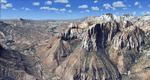
Covers the southern part of Zion National Park extends south along the cities of Hurricane and Colorado City. Zion National Park is another place where erosion of the Colorado Plateau formed the most beautiful colorful stone formations of unique and wonderful shapes. There are nine different layers of stone visible in the park. Most of them consist of sandstone. But there is also limestone, gypsum, siltstone, shale, clay and mudstone. The Virgin River cut a spectacular and famous canyon thru Zion Park that is as narrow as 20ft and up to 2000ft tall.
High resolution versions of this scenery for FS9 and FSX (much sharper, but larger and multiple downloads)
are available at www.blueskyscenery.com/CNY_South3West5.html . The screenies are taken from the high-res versions,
so expect this version to be slightly more blurry. Thanks to Joop Mak for providing custom AFCADs that
correct airport layouts so that they align with the photo-textures! They are available at www.blueskyscenery.com/AFCADs.html . YourDonation@Work: Dedicated to Jerry, Ralph J. and Lance.
| Filename: | Zion_National_Park_South_Hurricane_1L8_Colorado_Ci.zip |
| License: | Freeware, limited distribution |
| Added: | 20th March 2010, 23:26:42 |
| Downloads: | 1,784 |
| Author: | Gottfried Razek - blueskyscenery.com |
| Size: | 95.39 MB |
| Category: Flight Simulator 2004 - Scenery | |
| Milano Malpensa Area (ISD) 2013 |
|
Images related to this file:
File Description:
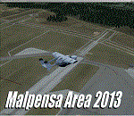
Dear Friends simmer, as always taking advantage of the beautiful objects bgl Gianluca Giovannini, I tried to improve with a symmetric pairing of autogen trees / towns / industrial buildings, the urban area near the international airport of Milano Malpensa, in the best ever scenery by the ISD project.
With the current integration I have created the village of Casenuove, Cardano al Campo, Cascina Costa, Femo, part of the small towns near the attached industrial buildings and new parking in 3D for both terminals. I paid particular attention to the impact of the approach in view of the Ticino Park with a significant density of trees near the runway. Inside you will also find the file on the grass in 3D previously published by me, so if you have already installed, you can deactivate maintaining this.
Warning Very Important: the scenery "is not complete" and to get the best result, you must install ISD LIMC 2009 (limc2009v1.1.zip) - available HERE.
| Filename: | Milano_Malpensa_Area_ISD_2013.zip |
| License: | Freeware |
| Added: | 22nd February 2013, 17:15:22 |
| Downloads: | 4,750 |
| Author: | Fabio Ferrari "fafo air" |
| Size: | 4.51 MB |
| Category: Flight Simulator 2004 - Scenery | |
| Tofino CYAZ 2012 |
|
Images related to this file:
File Description:
I've always had a particular fondness for Tofino CYAZ, located on the west coast of Vancouver Island. I made my first Tofino scenery in 2005 using Lago's FSE, and an updated version in 2006 using EZ-Scenery. Neither of those included custom models. This final version is a complete, from-the-ground-up rebuild. Every building and many of the other scenery objects are custom made based on photos and using photo textures. (The images in the "Tour" folder will take you on a tour of the real and virtual airport.) In the time since the first two virtual versions were made, a new terminal building has been added to the east ramp at the real Tofino, along with some new hangers, and the scenery includes these changes. Tofino has an NDB instrument approach (CYAZ NDB A.pdf), but night operations are not allowed. For this reason the new terminal building has no night lighting. The golf clubhouse restaurant and pro shop are open after dark for your shopping and dining pleasure. This scenery represents many hours of work...I hope you enjoy it.
| Filename: | Tofino_CYAZ_2012.zip |
| License: | Freeware |
| Added: | 19th August 2012, 14:33:09 |
| Downloads: | 650 |
| Author: | Sidney Schwartz |
| Size: | 10.14 MB |
| Category: Flight Simulator 2004 - Scenery | |
| Terrace CYXT in British Columbia, Canada - REVISED |
|
Images related to this file:
File Description:
This version includes the correct Piper Cub texture, unreported by all but one downloader (why?).
Terrace is fifteen miles east and inland from Prince Rupert, which is 500 miles north of Vancouver up the BC coast. It is at the point in the mountains where two fjords meet, one coming from Prince Rupert and the other from Kitimat. The airport is a couple of miles south of the town and on the south side of the Skeene River. There are two runways, and the main one is a recently-extended 7,500 feet long and lighted 33/15. The second is 5,373 feet of unlit 03/21. The apron has been enlarged to be able to accommodate a Boeing 737 so I have parked an Air Canada jet there, but the pics show the planes that do fly to Terrace, and these are Air Canada and Hawk Air Dash 8-300's. The original aircraft and the textures are down-loadable and and can be used for AI.
| Filename: | Terrace_CYXT_in_British_Columbia_Canada__REVISED.zip |
| License: | Freeware, limited distribution |
| Added: | 21st February 2010, 16:25:38 |
| Downloads: | 1,110 |
| Author: | Roger Wensley |
| Size: | 3.39 MB |
| Category: Flight Simulator 2004 - Scenery | |
| Nome PAOM on the northwestern coast of Alaska |
|
Images related to this file:
File Description:
There are four main northwestern Alaska towns which have good airports and are serviced by Alaska Airlines. From these airports local flights connect to nearby villages, "nearby" in Alaska meaning up to 200 miles away. The northernmost is Barrow. Southwest of Barrow is Kotzebue, then Nome, and the furthest south is Bethel. The town of Nome is south of the Bering Strait on the southern coast of the Seward Peninsula, around 185 miles south of Kotzebue, with a population of about 3,800. It is the town that led to the creation of the most famous dogsledge race in the world, the Iditarod, which is based on the delivery to Nome of diphtheria serum during the blizzard conditions of the winter of 1925. The Nome airport (it currently has no other name) was originally built as the last of the refuelling airfields for planes being ferried to Russia during WW2. It has two runways, aligned 09-27 and 02-20 in FS9 (the wandering magnetic north has recently renamed the magnetic headings) and both of them around 6,000 feet with an ILS on 27. There is a modern airport layout diagram included showing taxiway names etc. Alaska Airlines, ERA, and Bering Air (which is headquartered in Nome), along with the shared cargo terminal for Northern Air Cargo and Everts Air, are all on the southern apron. The northern apron is mainly for GA, along with maintenance facilities, a garage building that also houses a weather bureau, and at the far northern end of runway 02-20 an apron and hanger for the Alaska Air National Guard. All AI aircraft in FS9 much prefer to use a runway that has an ILS and so will continue to use 09-27 even if the wind is from the north or south, right up until it reaches 30+ knots, so for AI realism in FS9 a permanent wind from the west would be the most realistic on a daily basis. There is also a small gravel strip just north of the town and this is included (94Z), as are some old line-of-sight radio communication reflectors on the hills above the town. There is a note about making adjustments to Ultimate Terrain Alaska-Canada regarding both realistic road lighting and also auto-generation.
| Filename: | Nome_PAOM_on_the_northwestern_coast_of_Alaska.zip |
| License: | Freeware, limited distribution |
| Added: | 18th October 2016, 02:38:42 |
| Downloads: | 486 |
| Author: | Roger Wensley |
| Size: | 22.65 MB |
| Category: Flight Simulator 2004 - Scenery | |
| PADL - Dillingham - Alaska, USA |
|
Images related to this file:
File Description:
Dillingham is a town with a population of around 2,300 at the southeast corner of the Bering Sea in Bristol Bay, 70 miles west of King Salmon. The town's economical well being is based on the commercial price of salmon and the numerous surrounding sport fishing lodges. FS9 shows the town as way more extensive than it is; the landclass textures correct this. The airport is a mile west of the town and has a single runway 6,400 feet long and orientated 01-19. There are scheduled passenger flights by Alaska Air (numerous in summer and non-existant in winter) and PenAir (year around) plus cargo flights by Everts and Northern Air Transport, and local scheduled flights by Grant Air; the AI includes these, plus GA. The GA gravel apron is behind the main apron and across a road, which is unusual. The parking on the asphalt apron is marked; in actuality there are no markings but landing at a field in FS9 that doesn't have a control tower leaves one wondering where to go; the six spots at the far northern end are unused by AI and free for visitors.
| Filename: | PADL__Dillingham__Alaska_USA.zip |
| License: | Freeware, limited distribution |
| Added: | 14th May 2015, 17:35:29 |
| Downloads: | 393 |
| Author: | Roger Wensley |
| Size: | 10.39 MB |
| Category: Flight Simulator 2004 - Scenery | |
| CYCQ - Chetwynd - British Columbia, Canada |
|
Images related to this file:
File Description:
The town of Chetwynd (population around 2,600) is on the east side of the Rocky Mountains, the first town to be encountered when descending from the Rockies on highway 97. Previously known as Little Prairie, the town name was changed in 1962. The main occupations of the town are linked to forestry, fossil fuels, and transportation; there are railway lines north to Fort St John, east to Dawson Creek, and south to Prince George. The airport is on the southern side of the town, with one runway aligned 05-23, asphalted in 1975 and just under 4,500 feet long. There are no scheduled services, although a new terminal building was constructed in 2008, and the helicopter operations by at least two companies (oil and gas and medical evacuation flights) are the primary operations from the field. These are included in the AI, incorporating helicopter modifications made by Holger Sandmann so that they function properly as AI at an airfield. As an aside, landing like a plane and using the runway and taxiways is in fact exactly what a helicopter does at a normal airfield in real life; everyone does the same thing so that guessing is unneccesary.
| Filename: | CYCQ__Chetwynd__British_Columbia_Canada.zip |
| License: | Freeware, limited distribution |
| Added: | 28th March 2016, 21:36:33 |
| Downloads: | 298 |
| Author: | Roger Wensley |
| Size: | 18.84 MB |
| Category: Flight Simulator 2004 - Scenery | |
| Forggensee, v2 Update |
|
Images related to this file:
File Description:

This UPDATE enhances the existing Forggensee Water-Airport(EDAF).
Klaus Jone did a magnificent job in creating this scenery for us flightsimmers, and my enhancements do NOT alter any Scenery Objects by Klaus Jone. The buildings are the same. And the number of AI planes and ships are unchanged.
My enhancements modify the BEHAVIOR of the Ships.
But the floatplane traffic is so superbly programmed that no further modifications are necessary.
Mr. Klaus Jone passed away in May 2009, and it is my intention to preserve Forggensee pretty much as HE designed it. Except for modifying the BEHAVIOR of the AI traffic, to spread it out to cover the entire area of Lake Forggensee. As the screenshots I've included illustrate.
Naturally, these updated files require that Forggensee Part 1 and Part 2 are ALREADY installed in your FS2004. My part here was to perform a few tweaks to make the AI traffic spread out all over Lake Forggensee, and ensure that ALL wake/spray effects are visible. As Klaus Jone stated: "There is some amazing traffic on the lake, have a look and have fun!"
| Filename: | Forggensee_v2_Update.zip |
| License: | Freeware |
| Added: | 18th April 2011, 19:13:38 |
| Downloads: | 726 |
| Author: | Klaus Jone, Ronald Falzon |
| Size: | 1.41 MB |
© 2001-2026 AVSIM Online
All Rights Reserved
Privacy Policy |