
Where Flight Simulation Enthusiasts Gather from Around the World!
AVSIM Library - Search Results

| Category: Flight Simulator 2004 - Scenery | |
| South-east Asia SRTM Mesh Part 2 |

|
File Description:
This release covers all of following countries: Thailand, Laos, Kampuchea and Vietnam. Also include parts of Malaysia (Malacca peninsula), Burma (along Thai border) and China (along Vietnam and Laos borders). See SE-Asia-Mesh-part1-1.jpg for detail of BGL coverage. This part includes Thailand-W1 and Thailand-W2 BGL files. Based on SRTM Data (3 arcsec, 90m), generated with Matthew Styles's program "SRTM To BGL v1.04", sampled to LOD9 resolution (76m). John Childs's Blackart program was used to fix large void areas by merging with DTED0 data.
| Filename: | Southeast_Asia_SRTM_Mesh_Part_2.zip |
| License: | Freeware, limited distribution |
| Added: | 1st March 2004, 01:36:06 |
| Downloads: | 12,935 |
| Author: | Yohann Baptiste |
| Size: | 34.46 MB |
| Category: Flight Simulator 2004 - Scenery | |
| South-east Asia SRTM Mesh Part 3 |
|
File Description:
This release covers all of following countries: Thailand, Laos, Kampuchea and Vietnam. Also include parts of Malaysia (Malacca peninsula), Burma (along Thai border) and China (along Vietnam and Laos borders). See SE-Asia-Mesh-part3-1.jpg for detail of BGL coverage. This part includes Indo-1 to Indo-5 BGL files. Based on SRTM Data (3 arcsec, 90m), generated with Matthew Styles's program "SRTM To BGL v1.04", sampled to LOD9 resolution (76m). John Childs's Blackart program was used to fix large void areas by merging with DTED0 data.
| Filename: | Southeast_Asia_SRTM_Mesh_Part_3.zip |
| License: | Freeware, limited distribution |
| Added: | 1st March 2004, 01:39:13 |
| Downloads: | 12,793 |
| Author: | Yohann Baptiste |
| Size: | 35.85 MB |
| Category: Flight Simulator 2004 - Scenery | |
| South-east Asia SRTM Mesh part 4 |
|
File Description:
This release covers all of following countries: Thailand, Laos, Kampuchea and Vietnam. Also include parts of Malaysia (Malacca peninsula), Burma (along Thai border) and China (along Vietnam and Laos borders). See SE-Asia-Mesh-part4-1.jpg for detail of BGL coverage. This part includes Laos-N BGL file. Based on SRTM Data (3 arcsec, 90m), generated with Matthew Styles's program "SRTM To BGL v1.04", sampled to LOD9 resolution (76m). John Childs's Blackart program was used to fix large void areas by merging with DTED0 data.
| Filename: | Southeast_Asia_SRTM_Mesh_part_4.zip |
| License: | Freeware, limited distribution |
| Added: | 1st March 2004, 13:36:01 |
| Downloads: | 12,590 |
| Author: | Yohann Baptiste |
| Size: | 27.3 MB |
| Category: Flight Simulator 2004 - Scenery | |
| Lesser Antilles SRTM Mesh |
|
File Description:
This is a terrain mesh scenery for the whole lesser antilles, from the Anguilla Isl (north) to Trinidad Isl (south), including a small part of Venezuela.
Based on SRTM Data (3 arc/ sec), generated with Matthew Styles's program "SRTM To BGL v1.04", sampled to LOD9 resolution (76m) with 5 interpolation passes.
While tested under Fs2004, this mesh should also run in FS2002.
| Filename: | Lesser_Antilles_SRTM_Mesh.zip |
| License: | Freeware |
| Added: | 26th September 2003, 01:46:44 |
| Downloads: | 5,691 |
| Author: | Yohann Baptiste |
| Size: | 5.18 MB |
| Category: Flight Simulator 2004 - Scenery | |
| Datong Beijiazao Airport (ZBDT) |
|
Images related to this file:
File Description:
Scheduled operators at ZBDT: Air China, China Express, China Eastern, China Southern, & China United Airlines.
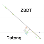
A basic "Google Earth" based scenery for the new Datong Beijiazao Airport (ZBDT) which is missing in FS9 stock version.
All airport features are accurately placed/shaped according to sat imagery. Navaids valid as AIRAC 1110.
It features basic default terminal, tower, and taxi signs.
ILS 32 & VOR 14 approaches coded for AI & UI.
| Filename: | Datong_Beijiazao_Airport_ZBDT.zip |
| License: | Freeware, limited distribution |
| Added: | 8th January 2012, 07:49:37 |
| Downloads: | 727 |
| Author: | Yohann Baptiste |
| Size: | 384.79 KB |
| Category: Flight Simulator 2004 - Scenery | |
| ZBCF - Chifeng Airport (Non-Stock) |
|
Images related to this file:
File Description:
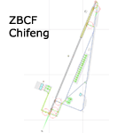
A basic google-earthed scenery for the new Chifeng airport which is missing in FS9 stock version.
All features accurately placed/shaped according to sat imagery. Navaids froms AIRAC cycle 1110.
Features basic default terminal & tower, and taxisigns. Includes code for ILS 21 approach with CHF VOR transition. Scheduled operators at ZBCF: Tiajin Airlines, China Eastern, Sichuan Airlines, Air China & China Express.
| Filename: | ZBCF__Chifeng_Airport_NonStock.zip |
| License: | Freeware, limited distribution |
| Added: | 29th December 2011, 23:13:00 |
| Downloads: | 725 |
| Author: | Yohann Baptiste |
| Size: | 323.84 KB |
| Category: Flight Simulator 2004 - Scenery | |
| ZBHD Handan Airport (Non-stock) |
|
Images related to this file:
File Description:
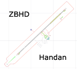
A google-earthed scenery for Handan airport which is missing in FS9 stock version, with basic default terminal & tower, and taxisigns.
All features accurately placed/shaped according to june 2010 sat imagery. Navaids valid as AIRAC 1110, with ILS 23 approach coded for AI & UI (HDH & WXI transitions).
Current scheduled operators at ZBHD: China Eastern, China Express Airlines, China Southern, Shenzhen airlines.
| Filename: | ZBHD_Handan_Airport_Nonstock.zip |
| License: | Freeware, limited distribution |
| Added: | 23rd January 2012, 21:37:26 |
| Downloads: | 595 |
| Author: | Yohann Baptiste |
| Size: | 536.42 KB |
| Category: Flight Simulator 2004 - Scenery | |
| ZLIC - Yinchuan/Hedong (Non-Stock) |
|
Images related to this file:
File Description:

A basic scenery for Yinchuan/Hedong airport which is missing in FS9 stock version.
All features accurately placed/shaped according to sat imagery & Chinese AIP AMD from Oct 15th 2011, including basic default terminal & tower, taxisigns, jetways, and ILS approach code for AI & UI users.
Scheduled operators at ZLIC: China southern, China Eastern, Joy Air, Hainan Airlines, Tianjin Airlines, Air Chinan, Sichuan Airlines, Shandong Airlines, Shenzhen Airlines & Xiamen Airlines.
| Filename: | ZLIC__YinchuanHedong_NonStock.zip |
| License: | Freeware, limited distribution |
| Added: | 29th December 2011, 23:15:38 |
| Downloads: | 1,039 |
| Author: | Yohann Baptiste |
| Size: | 307.2 KB |
| Category: Flight Simulator 2004 - Scenery | |
| ZGOW - Jieyang/Chaoshan |
|
Images related to this file:
File Description:
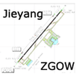
A basic scenery for Jieyang/Chaoshan airport which opened on Dec 18th 2011, replacing old Shantou/Waishan airport with the same ICAO/IATA codes: ZGOW/SWA.
All features accurately placed/shaped according to Chinese AIP SUP from Dec 15th 2011, with basic default terminal & tower, taxisigns, jetways, and ILS approach code for AI & UI users.
Scheduled operators at ZGOW: China southern (focus city), China Eastern, Tianjin Airlines, Air Chinan & Shandong Airlines.
| Filename: | ZGOW__JieyangChaoshan.zip |
| License: | Freeware, limited distribution |
| Added: | 29th December 2011, 23:15:11 |
| Downloads: | 977 |
| Author: | Yohann Baptiste |
| Size: | 504.08 KB |
| Category: Flight Simulator 2004 - Scenery | |
| WADL - Praya Lombok International Airport |
|
Images related to this file:
File Description:
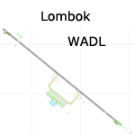
A basic scenery for new Lombok Intl airport which is missing in FS9 stock version. WADL replaced old Mataram airport (WADA/WRRA/AMI) which closed on september 30th 2011.
All features accurately placed/shaped according to charts from AIRAC cycle 1113.
Includes basic default terminal, tower, taxisigns, and the following xml-coded approaches for AI & UI: ILS 13, RNAV 13 & RNAV 31.
| Filename: | WADL__Praya_Lombok_International_Airport.zip |
| License: | Freeware, limited distribution |
| Added: | 10th January 2012, 14:20:07 |
| Downloads: | 3,366 |
| Author: | Yohann Baptiste |
| Size: | 309.24 KB |
© 2001-2026 AVSIM Online
All Rights Reserved
Privacy Policy |