
Where Flight Simulation Enthusiasts Gather from Around the World!
AVSIM Library - Search Results

| Category: Flight Simulator 2004 - Scenery | |
| Fort Graham CBW3 in British Columbia Canada |

|
Images related to this file:
File Description:
Fort Graham is what looks like a very small village on the eastern shore of Williston Lake in northern British Columbia, around 100 miles north of Mackenzie (a previous post). The lake, while not large by Canadian standards, is well over 100 miles long but squeezed in width to a maximum of 5 miles amid the surrounding Rockies. The airfield has a gravel runway of 5,000 feet aligned 13-31 and at 2,230 feet ASL. There is no lighting. The operator of the airfield (and presumably the "village" too) is Finlay River Outfitters, a company that is based in Mackenzie and "outfits" hunting trips in the local area. I have posted this as Fort Graham CBW3, but I suggest that you just add it to your previously created "BC airfields" and avoid the inevitable doubling up of common textures etc. Up to you. If you find a defect, email me.
| Filename: | Fort_Graham_CBW3_in_British_Columbia_Canada.zip |
| License: | Freeware, limited distribution |
| Added: | 23rd November 2020, 20:13:11 |
| Downloads: | 105 |
| Author: | Roger Wensley |
| Size: | 7.75 MB |
| Category: Flight Simulator 2004 - Scenery | |
| Kerkira Airport Enhancement |
|
File Description:
This is old scenery which has been updated for FS2004 and enhances the visual environment of Ionian sea island airport of Kerkira, also known as Corfu. Its part of my “Greek Airfields” package that currently is not fully compatible with FS2004 since MS decided to move the airports in Greece and elsewhere to adjacent positions and ASD, which I use for placing these objects, is not compatible with FS2004. Here you will find airport & terrain enhancements for Hellenic airport of Kerkira LGKR that make it look closer to the real one; hotels, runway turning bay, perimeter fences, windsocks, radio antennae, new approach radar antenna to the southwest and most importantly, an exclusion of autogen scenery that is wrongfully generated on each side of the runway. A big difference is attributed to Babis Peribolas’s Kerkira mesh terrain that is included in this scenery. Scenery includes the necessary ASD 2.1 textures.
| Filename: | Kerkira_Airport_Enhancement.zip |
| License: | Freeware, limited distribution |
| Added: | 4th September 2003, 02:23:06 |
| Downloads: | 12,173 |
| Author: | Kyprianos Biris |
| Size: | 1.94 MB |
| Category: Flight Simulator 2004 - Scenery | |
| Talkeetna Village AK44 in Alaska, REVISED |
|
Images related to this file:
File Description:
The town of Talkeetna is around 75 miles north of Anchorage in Alaska, on the east shore of the Susitna River where the Susitna, Talkeetna, and Chulitna rivers join. The town is where Don Sheldon started Talkeetna Air Services. His story is told in "Wager With The Wind" by James Greinar and is well worth reading for the descriptions of mountain flying. There are two airfields at Talkeetna, PATK with its long asphalt runway and Talkeetna Village AK44 in the town. This is AK44; measuring the space left for the runway between the river bank in the south and the curve in the road that marks the north end of the field there is just enough space for the 900 feet of runway that is described in the book. The result is a step back in time to 1973, when the second hangar was built. Neither hangar has survived to today.
| Filename: | Talkeetna_Village_AK44_in_Alaska_REVISED.zip |
| License: | Freeware, limited distribution |
| Added: | 18th April 2010, 09:52:26 |
| Downloads: | 869 |
| Author: | Roger Wensley |
| Size: | 3.47 MB |
| Category: Flight Simulator 2004 - Scenery | |
| PABV - Birchwood airfield - Anchorage, Alaska - USA |
|
Images related to this file:
File Description:
Birchwood PABV is in Alaska, some 20 miles northeast of Anchorage, on the south shore of Knik Arm. It is a smaller version of Merrill Field, almost entirely for just GA aircraft and the maintenance shops that a gathering of such aircraft attracts. The main runway is just over 4,000 feet long, aligned L01-R19 and asphalted and lit; this last is even more important in Alaska with short winter days. There is also a shorter and parallel runway that is gravel and which receives no winter maintenance; this is for winter use by planes that are on skis, rather than wheel/skis. This is not unusual and is found at other Alaska airfields. This scenery provides a place to fly to from my previous posts of Merrill Field and Lake Hood close to Anchorage. There will be others in this series, on the northern side of Knik Arm.
| Filename: | PABV__Birchwood_airfield__Anchorage_Alaska__USA.zip |
| License: | Freeware, limited distribution |
| Added: | 7th October 2014, 19:41:37 |
| Downloads: | 614 |
| Author: | Roger Wensley |
| Size: | 22.21 MB |
| Category: Flight Simulator 2004 - Scenery | |
| PGUA - Andersen AFB, Guam (V3) **UPDATE** |
|
Images related to this file:
File Description:

FS2004 scenery for Andersen AFB on the island of Guam. Andersen AFB started life as one of many airfields constructed in 1944 for the final aerial assault on the Japanese islands. Originally designed as a long range bomber base, Andersen has grown in scale to keep pace with the newest U.S. Air Force ships. Andersen remained busy during the Korean and Vietnamese conflicts hosting the 19th Bomb Wing as well as various SAC units for combat, refueling, and logistical/material support. The base is hosted by the 36th Wing and provides support services for all visiting and transient aircraft from numerous allied nations. This scenery contains all-new custom objects for Andersen AFB as well as photo-realistic ground cover for the airfield. MY SINCERE APOLOGIES TO ALL WHO HAVE PREVIOUSLY DOWNLOADED THIS SCENERY. PLEASE DELETE ANY EXISTING INSTALLATION AND REPLACE WITH THIS FINAL VERSION 3.
| Filename: | PGUA__Andersen_AFB_Guam_V3_UPDATE.zip |
| License: | Freeware, limited distribution |
| Added: | 27th April 2013, 22:29:34 |
| Downloads: | 2,309 |
| Author: | John Stinstrom |
| Size: | 2.58 MB |
| Category: Flight Simulator 2004 - Scenery | |
| Ontario Small Fields in Canada: #02 Harrow CGL2 |
|
Images related to this file:
File Description:
This is the second in a series of small airfields in southern Ontario, Canada. It is Harrow CGL2, a field near a small town of the same name close to Lake Erie. The airfield has a grass runway of 3,000 feet, with short displaced thresholds (400 feet) at each end; the south due to the trees and the north due to a road and fence. The electric cable strung along this road (unlike Leamington, with it's warning visibility spheres) is buried for a short stretch the width of the runway, but avoid the poles. The intention is that downloaders will add further posts to the earlier ones, which will avoid unnecessary texture duplication (for instance for parked cars or planes) and avoid adding yet another small field to the FS9 scenery library. The third airfield will probably be Essex CNE9, a grass field to the west of Harrow.
| Filename: | Ontario_Small_Fields_in_Canada_02_Harrow_CGL2.zip |
| License: | Freeware, limited distribution |
| Added: | 19th July 2015, 19:44:00 |
| Downloads: | 182 |
| Author: | Roger Wensley |
| Size: | 1.54 MB |
| Category: Flight Simulator 2004 - Scenery | |
| Ontario Small Fields in Canada: #03 Essex CNE9 |
|
Images related to this file:
File Description:
This is the third in a series of small airfields in southern Ontario, Canada. It is Essex CNE9, a field near a small town of the same name close to Lake Erie and just northwest of Harrow (visible in one of the screenshots). The airfield has a grass runway of just 1,935 feet, with electric cables strung along the west side of the road on the approach to 09, buried for a short stretch the width of the runway (but avoid the poles). The airfield has three hangars, not the first farm strip to have more than the expected one-for-the-farmer. The intention is that downloaders will add further posts to the earlier ones, which will avoid uneccesary texture duplication etc. The fourth airfield will probably be Stoney Point CRML, a grass field to the northeast of Essex, close to Lake St. Clair.
| Filename: | Ontario_Small_Fields_in_Canada_03_Essex_CNE9.zip |
| License: | Freeware, limited distribution |
| Added: | 21st July 2015, 16:11:05 |
| Downloads: | 153 |
| Author: | Roger Wensley |
| Size: | 3.64 MB |
| Category: Flight Simulator 2004 - Scenery | |
| Ford-Timor (Jump Ramp Heaven) |
|
Images related to this file:
File Description:
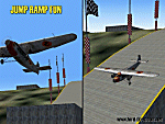
6 different layers in one pack. This scenery pack is a fun experiment in Jump Ramp development - to get aircraft to launch into the air.
Many different angles and many different challenges for your fun flying pleasure.
Contains lots of small and large Jump Ramps, a couple of Ski Ramps and a Grass up/down Hill Runway.
Also contains an Aircraft Carrier with two jump ramps and an Airship with a runway and jump ramp on top.
All set up on 6 different height levels - absolute fun flying and some great challenges for takeoff and landings.
BONUS AIRFIELDS
For those that already have Ford-Blackhawk, Ford-Brazil and Ford-Switzerland installed - a collection of files are included in the Ford-Timor project that will add ramps and jumps to these packages.
Slideshow to show you what is included:
http://www.ford-tri-motor.net/Slideshows/JUMP_RAMP_HEAVEN.html
| Filename: | FordTimor_Jump_Ramp_Heaven.zip |
| License: | Freeware, limited distribution |
| Added: | 16th July 2016, 14:34:48 |
| Downloads: | 80 |
| Author: | Garry J. Smith - Ford Project Team |
| Size: | 3.91 MB |
| Category: Flight Simulator 2004 - Scenery | |
| 8AK7 - Bullen Point - Alaska North Slope 7 |
|
Images related to this file:
File Description:
The town of Barrow is in the far north of Alaska, and these are coastal villages or radar installations to the west, south, and now east of Barrow. There will be further additions. Bullen Point is a DEW station Air Force base 240 miles east of Barrow and 75 miles east of Oliktok. The runway is just under 4,000 feet of gravel and aligned 05-23; this is approximately at right angles to the default FS9 alignment and how that came about is something I doubt Bill Gates could explain. Most of the DEW buildings have now been removed (including the large hangar, which is unusual) but as I had a layout I made the whole site as it was originally, way back in the days when the north slope was still a wilderness. The AI is one day a C-130, on another a Cessna, and on a third a DC3. When I started this North Slope series it was my intention to create the full monty and make all the oil and gas installations and Deadhorse airport etc. I have come to realise that the oil side is impossible to make. There is so much of it and each bit is as time consuming as Heathrow while the actual airfields are more like Rockcliffe CYRO, so a lot of effort for what is just background to an adjoining airfield. But at the same time, if I make the new airstrips it is impossible NOT to make the oil installations as they are the dominating feature. So no new airstrips, and this is going to be just the 1960's or 1970's, when the oil business was only exploratory and the airfields were for villages or DEW stations, and Harmon Helmerick had his dirt strip on the Colville River estuary and was guiding hunters and fishermen and had just started to help out Sinclair Oil with oil exploration in 1966. Read his book. Download my previous post of his field.
| Filename: | 8AK7__Bullen_Point__Alaska_North_Slope_7.zip |
| License: | Freeware, limited distribution |
| Added: | 15th July 2016, 17:46:54 |
| Downloads: | 277 |
| Author: | Roger Wensley |
| Size: | 2.5 MB |
| Category: Flight Simulator 2004 - Scenery | |
| FS2004 Scenery World War II Naval Air Stations. |
|
Images related to this file:
File Description:

FS2004 Scenery--World War II Naval Air Stations. Leading up to the Second World War, the United States pursued a rush building program for airship bases. These bases were designed to support fleets of blimps that would patrol its coasts and help protect its vulnurable shipping lanes. Together these bases boasted fourteen airdocks which are widely believed to be the largest free-standing wooden buildings ever constructed. Although time and misfortune have destroyed most of them, this scenery will bring them back in their heyday of the early 1940's. This scenery package contains all eight of these wartime Naval Air Stations; Weeksville, North Carolina (NC), Hitchcock, Texas (TX), Glynco, Georgia (GA), Santa Ana, California (CA), Richmond, Florida (FL), Houma, Louisiana (LA), South Weymouth, Massachusetts (MA), and Tillamook, Oregon (OR). As a bonus for your patience you will also find the seaplane base at Tongue Point OR and a custom scenery addon package of ground crews and vintage vehicles. This is a stand alone scenery package and requires the removal of any and all previous versions. Re-upload of previous file due to library hack. By John Stinstrom.
| Filename: | FS2004_Scenery_World_War_II_Naval_Air_Stations.zip |
| License: | Freeware, limited distribution |
| Added: | 27th May 2010, 09:37:53 |
| Downloads: | 901 |
| Author: | John Stinstrom |
| Size: | 11.09 MB |
© 2001-2026 AVSIM Online
All Rights Reserved
Privacy Policy |