
Where Flight Simulation Enthusiasts Gather from Around the World!
AVSIM Library - Search Results

| Category: Flight Simulator 2004 - Scenery | |
| FSFlightline FSE Vol. 1: Enumclaw, WA (WA77) & Pacemaker Landing Zone, WA (KZ0A) |

|
File Description:
The first volume in a series of sceneries designed with and made for LAGO's Flight Simulator Enhancer (FSE). This first volume includes fictional depictions of Enumclaw, WA (WA77) and Pacemaker Landing Zone (KZ0A). Sceneries include ambient sounds, dynamic scenery movement, and special AFCADs for both airfields. Enjoy the songbirds and eagles flying overhead, the working farms, and vehicles moving about the nearby roads. Requires LAGO's Flight Simulator Enhancer to function.
| Filename: | FSFlightline_FSE_Vol_1_Enumclaw_WA_WA77__Pacemaker.zip |
| License: | Freeware |
| Added: | 1st February 2004, 02:43:43 |
| Downloads: | 635 |
| Author: | Jeff Shields |
| Size: | 181.97 KB |
| Category: Flight Simulator 2004 - Scenery | |
| UKmil Harrier Ski-Jump for UK2000 Scenery |
|
File Description:
This add-on will add a working Harrier Ski-Jump to Gary Summons UK2000 Wittering and Yeovilton sceneries. It should work with the following payware sceneries; UK2000 Part 2 and Part 5, RAF Airfields South and a last minute addition Just Flights British Airports Central & SW.
For custom AI aircraft and flight plans, add the ukmil Harrier which will use the Skijump. Go to www.ukmil.org.uk and have a look.
| Filename: | UKmil_Harrier_SkiJump_for_UK2000_Scenery.zip |
| License: | Freeware, limited distribution |
| Added: | 10th November 2007, 00:26:31 |
| Downloads: | 824 |
| Author: | Stephen Legg |
| Size: | 1.93 MB |
| Category: Flight Simulator 2004 - Scenery | |
| Airstrips east of the Alps |
|
File Description:
A collection of over 70 small airfields in Hungary, Slovakia, Slovenia and Croatia, many of which aren't featured in FS2004, each enhanced with taxiways, parking spaces, buildings etc. and aprons as appropriate, to fill in a few gaps to the north-east of Italy and to allow the generation of lightweight GA AI traffic in this area and into the adjacent countries.Again, there's no photo-realism here, just a selection of basic 'generic' buildings, more or less accurately sized and placed to reflect the airfield layout as seen on on-line satellite imagery and aerial photography. These buildings have minimal effect on frame-rates, so are ideal for this kind of job. The airfields are aligned as well as possible with the roads etc. in UT Europe, where applicable, and the Genesis Europe mesh, but should mostly be fine in a default installation or other configuration.
| Filename: | Airstrips_east_of_the_Alps.zip |
| License: | Freeware |
| Added: | 12th September 2025, 13:29:14 |
| Downloads: | 56 |
| Author: | Chris Eve |
| Size: | 785.49 KB |
| Category: Flight Simulator 2004 - Scenery | |
| Kangirsuk CYAS in Quebec Canada |
|
Images related to this file:
File Description:
Kangirsuk is an Inuit village in northern Quebec, on the coast of Ungava Bay. The airport is the only means of access on this coast for the population of around 550, apart from a period in late summer. It is between Quaqtaq and Aupaluk, and around 140 miles north of Kuujjuaq, a major centre in this area for supplies, medical care, education, and anything to do with local government. This version of the airport and village is from around 2010, with the original terminal building that has now been replaced. The runway is just under 3,500 feet of lit gravel aligned 04-22 and the AI includes the daily Air Inuit flight that connects Kangirsuk with Kuujjuaq and other local airfields en route. This is almost certainly the last of the northern Quebec coastal airfields that I will be able to model with the correct buildings; only two missing so not too bad.
| Filename: | Kangirsuk_CYAS_in_Quebec_Canada.zip |
| License: | Freeware, limited distribution |
| Added: | 27th August 2020, 17:41:07 |
| Downloads: | 84 |
| Author: | Roger Wensley |
| Size: | 5.67 MB |
| Category: Flight Simulator 2004 - Scenery | |
| Cache Creek CAZ5 in British Columbia Canada |
|
Images related to this file:
File Description:
Cache Creek is a small village of around 1,000 folks on the eastern side of the Coast Mountains of British Columbia, around 70 miles northeast of Pemberton and 40 miles west of Kamloops. The village is in a valley bottom and recently suffered from severe flooding due to the overflow of the river. The airfield is high above the town, with a runway aligned 15-33 and 3,280 feet of asphalt, without runway or taxiway lighting; hence "airfield" as opposed to "airport". I have posted it as Cache Creek CAZ5, but I suggest that you revise the name to perhaps "BC airfields" and just load my future airfield posts into the same scenery and texture folders to avoid the inevitable doubling up of common textures etc. Plus that way you will have just one FS9 library post to do and new airfields will not need yet another posting. Up to you. If you find a defect, email me.
| Filename: | Cache_Creek_CAZ5_in_British_Columbia_Canada.zip |
| License: | Freeware, limited distribution |
| Added: | 18th November 2020, 01:21:22 |
| Downloads: | 94 |
| Author: | Roger Wensley |
| Size: | 9.27 MB |
| Category: Flight Simulator 2004 - Scenery | |
| Southwestern Ontario Part 1 - Version 1.0 |
|
File Description:
I decided to make Southern Ontario much more interesting for flight simulator general aviation pilots. I have released several packages already but this is by far the most complex. London International Airport will be very lively with this addon. During testing I was cleared number 5 for landing on one occasion! I made the AI plans to account for your traffic amount setting so on a lower system you will have less planes so you’re performance doesn’t die on you.
This package is fully compatible with all of my other releases and all of the Project AI official releases. It only uses default MS aircraft so no additional downloads are required.
Overall
• 7 Improved airports – London, Woodstock, Tillsonburg, Straffordville, Stratford Municipal, Strathroy and St. Thomas.
• 43 flight plans
• 64 new parking spaces
• 3 new gates
| Filename: | Southwestern_Ontario_Part_1__Version_10.zip |
| License: | Freeware, limited distribution |
| Added: | 14th November 2003, 03:58:59 |
| Downloads: | 1,659 |
| Author: | David Voogd |
| Size: | 780.81 KB |
| Category: Flight Simulator 2004 - Scenery | |
| Cyprus: Airfields plus landmarks and land class for all of Cyprus and AI |
|
Images related to this file:
File Description:
Cyprus, an island in the eastern Mediterranean. Without the benefit of Ultimate Terrain, which does not exist for Cyprus, the land class provided by FS9 stands out as hopelessly inadequate. I have added the extensive farmland and the larger towns and villages, plus the major roads. Four completely new airfields are included here, three in the north and one in the south. Ercan LCEN is in the north and functions as the airport for all of the north. It was recently closed for two years while a new terminal was built and the runway updated and an apron extended etc, and during that time Gecitkale LCGK functioned (barely) as the airport for the north. Gecitkale is now hardly used at all. The third northern airfield is Ilker Karter LCIK and this functions as the HQ base of the Turkish Army Corp in northern Cyprus. The last of the new airfields is Kingsfield LCRE, which is in the Sovereign Base area to the east of Larnaca and is now used for recreational purposes. Ercan is now undergoing further expansion with a new runway and a new terminal building and apron, so this scenery is for the period between 2010 to 2015. My set up of Cyprus already included a payware Larnaca by Aerosoft (now only 12 euros) plus a freeware Paphos, Nicosia, and Akrotiri; that was my starting point. Larnaca has been the major airport for Cyprus since the mid 1970's, with a huge tourist trade that peaks in the summer but which is year long (almost a million Brits visit every year, let alone the other nationalities). I have adapted this (gate sizes etc) to allow parking by a multitude of B737's and others. Nicosia is freeware (posted in 2010) and I have included modifications to reflect its now total disuse. Paphos is at the far western end of the island and freeware, and I have modified this to allow larger and military ai aircraft to function properly; the poster improved his first version to better cater for ai but I was unaware of this and I have stayed with my modifications. Akrotiri is freeware and includes a lot of library object input from MAIW. I have modified the parking somewhat and added further residential areas and munitions storage. The AI is based upon recorded take offs and landings in April, with some further additions in later months. At Ercan the visible gate numbers on the apron are as per real life, but the numbers within FS9 reflect the fact that planes are directed to gates at the centre of the terminal building and not at the far ends. Follow the pink line and obey ATC when it says taxi to gate number 2 even if it is visibly numbered 4.
| Filename: | Cyprus_Airfields_plus_landmarks_and_land_class_for.zip |
| License: | Freeware, limited distribution |
| Added: | 13th August 2017, 21:21:46 |
| Downloads: | 940 |
| Author: | Roger Wensley |
| Size: | 29.61 MB |
| Category: Flight Simulator 2004 - Scenery | |
| LPPN_PROENCA V2.1 |
|
File Description:
Proenca-a-Nova scenery 2.1
This version upgrades the scenery to english language once some portuguese caracters are not recognized (I even altered some from my name). Also changed the name of a night texture wich could make a crash). Simply extract the zip and overight all files. Hope you enjoy. More portuguese small airfields to come soon.hemus_air_su07.zip
This scenery is to be used with freware PTSIM Portugal Terrain (http://www.ptsim.com/)
| Filename: | LPPN_PROENCA_V21.zip |
| License: | Freeware |
| Added: | 11th December 2009, 00:49:39 |
| Downloads: | 623 |
| Author: | Joao A. Graca Ferreira |
| Size: | 3.72 MB |
| Category: Flight Simulator 2004 - Scenery | |
| Washington Short Hops, 3 Sceneries for Washington State, USA |
|
File Description:
Washington Short Hops, like my Québec and Maine Short Hops, will be a series of close airfields aimed at VFR flying between the nice mountains of Washington. This first series consist of: Cozy Corner, Great Bear Lodge and Bill Calen's Still. All are fictitious and freeware for the basic scenery. You can add lots of candies and life to the scenery by sending a small shareware fee. See the pictures. Details in the download.
| Filename: | Washington_Short_Hops_3_Sceneries_for_Washington_S.zip |
| License: | Check within download |
| Added: | 27th February 2006, 04:16:49 |
| Downloads: | 1,313 |
| Author: | Leon Louis |
| Size: | 6.85 MB |
| Category: Flight Simulator 2004 - Scenery | |
| Sand Ground Service Vehicle Library |
|
Images related to this file:
File Description:
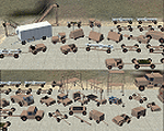
I made these objects at the request of a user who wanted something he could use in desert or arid military airfields. This is essentially an abbreviated set of my green vehicles with a repaint into the pink/tan desert colors currently used by the U.S. military. As with all my work the emphasis is on Frame-Rates and not microscopic reality so squint a little and pretend. PLEASE READ THE INSTALLATION NOTES CAREFULLY.
| Filename: | Sand_Ground_Service_Vehicle_Library.zip |
| License: | Freeware, limited distribution |
| Added: | 27th April 2014, 05:35:17 |
| Downloads: | 1,373 |
| Author: | John Stinstrom |
| Size: | 779.12 KB |
© 2001-2026 AVSIM Online
All Rights Reserved
Privacy Policy |