
Where Flight Simulation Enthusiasts Gather from Around the World!
AVSIM Library - Search Results

| Category: Flight Simulator 2004 - Scenery | |
| Whitefish 58S in Montana US |

|
Images related to this file:
File Description:
I have made this because I downloaded and tried the Glacier Park scenery by Blue Sky Scenery and then discovered that the runway for Whitefish was wrongly aligned and headed off across the adjacent railroad tracks. This would be inconvenient if you had to wait for a train to pass before landing so I fixed that and added a couple of buildings. That's it, nothing more complicated than that. If I find some more airfields in this area with similar problems then I'll do more of the same. Whitefish is 3 or so miles north of Glacier Park International at 3,066 feet ASL and around 35 miles south of the Canadian border. There are no large towns close by; the nearest would be Missoula, which is 90 miles further south.
| Filename: | Whitefish_58S_in_Montana_US.zip |
| License: | Freeware, limited distribution |
| Added: | 23rd May 2010, 02:05:52 |
| Downloads: | 194 |
| Author: | Roger Wensley |
| Size: | 826.52 KB |
| Category: Flight Simulator 2004 - Scenery | |
| Iles de la Madeleine CYGR in Quebec Canada |
|
Images related to this file:
File Description:
The Iles de la Madeleine are a group of spit islands linked by bridges in the Gulf of St Lawrence. They are east of New Brunswick, north of Cape Breton Island, west of the Island of Newfoundland, and south of the mainland coast of Quebec. On a southwest to northeast axis they are 40 miles in length and the airport CYGR is pretty much at the midpoint of the southern line of islands. Take a look at the overhead from FS9 to see what I mean. CYGR has two runways, one is aligned 08-26 and is just under 4,400 feet long and 150 feet wide with lighting and PAPI at both ends. The second is aligned 16-34 and is 3,600 feet long and 150 feet wide, without lights or PAPI. Both are asphalt. The apron is not huge, and a newish (in 2010) hangar was built with separate access to the 16-34 runway. There are daily flights by Air Canada and Pascan Aviation included in the AI. The AI also includes some boats and a ferry, and I first used these with my Dutch Harbor scenery, so if you have that already.... This scenery also includes Cindy Hook, a small boat harbour just 2 miles southwest of the airport, and the larger harbour at Cap aux Meules a further 3 miles away that accommodates the daily ferry trips, along with fishing boats etc. Also included here is a further addition to the Homer PAHO scenery in the shape of a boat that is included in the Homer Spit harbour. Just add the contents of the scenery folder to the Homer scenery folder of your Homer installation, and the texture folder contents to the Homer texture folder. This is hopefully the last PAHO addition, and again apologies. If you find an error email me please, and note that my email address has been changed to rogwens at Gmail dot com.
| Filename: | Iles_de_la_Madeleine_CYGR_in_Quebec_Canada.zip |
| License: | Freeware, limited distribution |
| Added: | 28th July 2021, 17:02:18 |
| Downloads: | 188 |
| Author: | Roger Wensley |
| Size: | 26.7 MB |
| Category: Flight Simulator 2004 - Scenery | |
| Gananoque CNN8 in Ontario, Canada |
|
Images related to this file:
File Description:
Gananoque is an ex-RCAF airfield 20 miles east of Kingston and Lake Ontario and 5 miles north of the Thousand Islands area of the St. Lawrence River and the US border. The airfield was a relief landing field for Kingston during WW2 and opened in 1940 with the classic triangle of runways. It closed in 1945 and is now a sky diving centre, still with the original single hangar and control tower. Fuel is no longer sold there so the only reason to pass by is as part of a visit to the Thousand Islands area, or perhaps look at the Canso (Canadian name for the PBY Catalina) which I understand is in the hangar. Unfortunately, when I turned up there was nobody there. The runways and the taxiways and the apron are all still usable but in what can only be called a state of random disrepair. Centre lines and signage are luxuries. I have included a photo with runway headings indicated.
| Filename: | Gananoque_CNN8_in_Ontario_Canada.zip |
| License: | Freeware, limited distribution |
| Added: | 22nd March 2012, 17:27:11 |
| Downloads: | 284 |
| Author: | Roger Wensley |
| Size: | 3.2 MB |
| Category: Flight Simulator 2004 - Scenery | |
| Boulder (KBDU) / Longmont / Loveland, Colorado, Photo-Scenery (FS9 & FSX) |
|
Images related to this file:
File Description:

Boulder is situated where the Rocky Mountains meet the Great Plains. Just west of the city are imposing slabs of sedimentary stone tilted up on the foothills, known as Flatirons. Located at the base of the foothills is Boulder's main campus of the University of Colarado which is clearly visible from the sky. Longmont is home of the Denver ARTCC (Air Route Traffic Control Center) which controls all flights in the upper airspace of most of Colorado and parts of adjoining states. To explore the scenery depart from Boulder (KBDU) and head northeast. Extends my Rocky Mountain Park scenery to the east and my Denver scenery to the north. Provides another 3.500 sq km in 4.7m/pix quality. High resolution versions for FS9 and FSX (much sharper, but larger and multiple downloads) are available at www.blueskyscenery.com/GNB_East.html . The screenies are taken from the high-res versions, so expect this version to be slightly more blurry. YourDonation@Work: Dedicated to Senges and Eric.
| Filename: | Boulder_KBDU__Longmont__Loveland_Colorado_PhotoSce.zip |
| License: | Freeware, limited distribution |
| Added: | 28th December 2009, 20:14:09 |
| Downloads: | 2,384 |
| Author: | Gottfried Razek - blueskyscenery.com |
| Size: | 94.26 MB |
| Category: Flight Simulator 2004 - Scenery | |
| Sunnyvale Air Station circa 1933 |
|
Images related to this file:
File Description:

FS2004 Scenery for Sunnyvale Air Station circa 1933. Known for 75 years as Moffett Field Naval Air Station, this unique site started life as Sunyvale Field (then Air Station) and was planned as the west coast base of the new Dirigible U.S.S. Macon.
The Macon was a new direction for airships in that it carried a squadron of fighter/scout aircraft and would provide for the U.S. Navy a 'carrier in the sky'. To provide for this new queen of the skies a new base was created with a unique hangar, for many years the largest free-standing wood construction in world.
This scenery attempts to capture Sunnyvale as it was first opened in 1933. I have taken a few liberties like adding in full grown trees that were part of the original master plan but I believe you will find this base captures the spirit of the original. Scenery contains custom FSDS and Gmax models as well as period AI from J.R. Lucariny (F9C SParrowhawk) and a custom repaint of the default Ford Trimotor by Ed Moore and Gary Smith.
| Filename: | Sunnyvale_Air_Station_circa_1933.zip |
| License: | Freeware, limited distribution |
| Added: | 2nd April 2012, 11:51:11 |
| Downloads: | 436 |
| Author: | John Stinstrom |
| Size: | 6.59 MB |
| Category: Flight Simulator 2004 - Scenery | |
| Legnano scenery - Italy |
|
Images related to this file:
File Description:
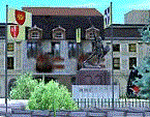
Homage to my town, scenery built mainly with existing objects, buildings by sintax and few experiments by GMax. It DOES NOT include any airport, but represents some pictures of Legnano town
Informations: Legnano is a town in north of Italy (approx 25 kmt NW Milan, ref coordinates N45 35.98 E8 54.59), reachable from Casorezzo ultralight airport (closest one) or all the near others of Milan area.
Here was done in 1176 the historical fight of the Alliance Lombarda's city-states against Federico Barbarossa German imperator. Legnano is also well known for his metallurgical and textile industries story.
Contents: rev.1 : down town square with municipal Palazzo Malinverni and S. Magno basilica, skyscraper, one of Olona river's bridges, G. Mari football stadium, Alberto da Giussano circus with related monument, encircled by the eight quarter's flags, F. Tosi and Manifattura industrial buildings, Rail station, external parking and glass building
rev.2 : Courthouse building with Teresa's face bronze statue and some more buidings, Palio hystorical figurants inside the stadium, Carroccio and Alberto da Giussano rider, Small goods train on railroad; S. Magno belltower reviewed, red sky-lights on top of skyscraper and chimney, Chimney smoke
| Filename: | Legnano_scenery__Italy.zip |
| License: | Freeware |
| Added: | 27th March 2011, 02:55:40 |
| Downloads: | 648 |
| Author: | Aldo Della Vedova |
| Size: | 6.83 MB |
| Category: Flight Simulator 2004 - Scenery | |
| Ferndale 53U in Montana US |
|
Images related to this file:
File Description:
I have made this because I downloaded and tried the Glacier Park photo land-class scenery by Blue Sky Scenery and then rediscovered that the airfield runways are not correctly positioned or aligned in FS9. So I corrected the Ferndale runway and while I was there also added 33 hangars and some parked planes. Of course, as all I know about the hangars is the colour of the roof this isn't up to total realism. It is, however, better than nothing and as I have a large stock of hangars from other sceneries not much effort was involved.
Ferndale is an "airpark" type of airfield where folks build their houses and hangers around the field, plus it also has a bunch of hangars; it is the "bunch" that I have replicated, as I have no idea at all what the houses look like. The field is 20 miles southeast of Glacier Park International at 3,060 feet ASL and around 55 miles south of the Canadian border. There are no large towns close by; the nearest would be Missoula, which is some 70 miles further south.
| Filename: | Ferndale_53U_in_Montana_US.zip |
| License: | Freeware, limited distribution |
| Added: | 29th May 2010, 17:54:14 |
| Downloads: | 291 |
| Author: | Roger Wensley |
| Size: | 2.26 MB |
| Category: Flight Simulator 2004 - Scenery | |
| Sulphur Creek Ranch ID74 private airfield in Idaho USA |
|
Images related to this file:
File Description:
This airfield is in the mountains of Idaho, around 30 miles south of Johnson Creek 3U2 which was the third in the series to be posted. Sulphur Creek Ranch is a privately owned airfield, serving the "Ranch", which translates into "restaurant-bar-lodge-and-holiday-cabins". The field is at 5,744 feet ASL, and the runway is 2,920 feet long and aligned 10-28. It is a single-ended runway, with 28 used for landing and 10 for take offs; this is down to a large chunk of mountain occupying the sky at the western end of the runway. The AI planes comply with this single runway concept and the only snag is that you cannot announce a landing as there is no runway offered for you to select for landing in the AI procedure. When taking off runway 10 is offered and you can announce take off. The land used by the ranch is mostly flat, and with a slant approach on finals and a late turn it is fairly straightforward. The largest landark is the man-made lake. Morgan Ranch 02ID is nearby and the grass area has been modified down in size as per reality. The buildings have been omitted as they are not adjacent to the runway and not visible, and I have no information on them.
| Filename: | Sulphur_Creek_Ranch_ID74_private_airfield_in_Idaho.zip |
| License: | Freeware, limited distribution |
| Added: | 25th May 2017, 17:54:33 |
| Downloads: | 164 |
| Author: | Roger Wensley |
| Size: | 6.21 MB |
| Category: Flight Simulator 2004 - Scenery | |
| Lechfeld, v2 |
|
Images related to this file:
File Description:
This airbase, located about 35 NM in the west of Munich (Bavaria, South Germany),
is the homebase of JaBoG32 riding the Tornado PA200. The German flight check
department GMFS, using C-47 in the early days and thereafter Hawker-Siddeley 748
as well as HS-125 for periodic recalibration of the radar- and navigational
equipment at civil and military airfields, was also on the base till 1994.
After the final decision was made not to establish commercial air traffic although
it had been discussed for a long time period, I reworked the airbase completely.
Among other objects, 38 hardened shelters for combat aircraft have been emplaced.
The included AI-Package contains: Lockheed F-104E GAF, Panavia Tornado PA200 GAF,
Mikoyan MiG-29 GAF, Douglas C-47 GAF, Canberra B.20 GAF, Boeing E3A Nato, Boeing
KC-135 USAF and an aircraft.cfg for the MS Learjet 45.
Several F104's, Tornadoes and MiGs perform touch and goes in the local area,
a Nato E3A leaves IFR to Geilenkirchen (ETNG), an USAF KC-135 routes IFR to
Decimomannu (LIED), a Canberra B.20 (was used for high altitude validations) goes
IFR to Cologne (EDDK) high in the sky and a Learjet shoots IFR to Bremen (EDDW) per
attached flight plan.
Lago's FSE is required in order to see most of the emplaced buildings /objects.
Lets get ready to rumble, but keep in mind, don't argue with the flight checkers
if they are on duty.
| Filename: | Lechfeld_v2.zip |
| License: | Freeware |
| Added: | 12th April 2011, 13:26:46 |
| Downloads: | 1,418 |
| Author: | Klaus Jone |
| Size: | 5.43 MB |
| Category: Flight Simulator 2004 - Scenery | |
| Steamboat Springs (KSBS), Flat Tops Wilderness Area, Colorado - Photo-Scenery |
|
Images related to this file:
File Description:

Steamboat Springs (KSBS), Flat Tops Wilderness Area, Colorado, Photo-Scenery (FS9 & FSX)
The Flat Tops Wilderness Area, which is the second largest wilderness area in Colorado, is named for its many flat topped mountains that are clearly visible from the sky. Trappers Lake, located in the north of the area inspired Arthur Carhart, a US Forest Service official, to initiate a plea for Wilderness preservation as early as 1919. Finally in 1975, three years before his death in 1978, the Flat Tops were designated a wilderness area. No wonder he found the area so entrancing: Behind Trappers Lake loom majestic volcanic cliffs, and beyond them a vast subalpine terrain reluctantly yields to alpine tundra with an average elevation of about 10.000 feet. More than 100 lakes dot the country above and below numerous flat-topped cliffs. Steamboat Springs is an internationally known winter resort destination.
To explore the scenery depart from Steamboat Springs Airport (KSBS) or Yampa Valley Airport (KHDN) and head south. High resolution versions of this scenery for FS9 and FSX (much sharper, but larger and multiple downloads) are available at www.blueskyscenery.com/GNB_West2.html . The screenies are taken from the high-res versions, so expect this version to be slightly more blurry. Thanks to Joop Mak for providing custom AFCADs that correct airport layouts so that they align with the photo-textures! They are available at www.blueskyscenery.com/AFCADs.html . YourDonation@Work: Dedicated to James.
| Filename: | Steamboat_Springs_KSBS_Flat_Tops_Wilderness_Area_C.zip |
| License: | Freeware, limited distribution |
| Added: | 26th April 2010, 17:53:25 |
| Downloads: | 1,302 |
| Author: | Gottfried Razek - blueskyscenery.com |
| Size: | 91.57 MB |
© 2001-2026 AVSIM Online
All Rights Reserved
Privacy Policy |