
Where Flight Simulation Enthusiasts Gather from Around the World!
AVSIM Library - Search Results

| Category: Flight Simulator 2004 - Scenery | |
| New Night Textures - Newark Liberty Intl (KEWR) |

|
Images related to this file:
File Description:
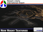
Some time ago, I purchased the Newark Liberty Intl (KEWR) by ImagineSim, but the night textures did not seem realistic. I set out to try to make them more so. This is the result of that work. Many of the scenery's night textures have been updated. The cargo areas for FedEx, UPS and UNITED Cargo now look much more realistic. The Marriott Hotel, the centerpiece of the airport and this scenery, looks considerably more realistic, as well as the terminals and the Continental Hanger and maintenance area. One of the nice unexpected results of this change is the light splash effect around the terminals; it definitely outlines the terminal area well. For those who own this scenery, I hope this enhances your flight experiences in and out of KEWR. For those who do not yet own this, but enjoy or would like to fly in and out of KEWR, it is now considered a legacy product by ImagineSim. As a result, the price was cut considerably and for a few shillings and this update, you'll have a nice addition to the airports in your FS2004 environment. I dedicate this work to all the controllers of VATSIM NYARTCC. I hope this brings more traffic your way. I want to thank ImagineSim for giving me permission to release these textures. See Readme.txt for installation instructions.
| Filename: | New_Night_Textures__Newark_Liberty_Intl_KEWR.zip |
| License: | Freeware, limited distribution |
| Added: | 27th October 2012, 03:48:59 |
| Downloads: | 2,292 |
| Author: | Jeffrey S. Bryner, Imagine Simulation |
| Size: | 1.97 MB |
| Category: Flight Simulator 2004 - Scenery | |
| Hazyview Airfield, Hazyview, South Africa |
|
Images related to this file:
File Description:
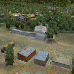
Hazyview is one of the gateway towns to the Kruger National Park and is located just to the West of Phabeni Gate, one of the main gates to use if you are travelling to Skukuza. The airfield in Hazyview is also called Numbi Airfield due to the location of the Numbi Hotel right next to the airfield.
Hazyview airfield is not included in the default scenery of FS2004. With this package, it has been faithfully produced in Gmax with photoreal textures on all the buildings and a photoreal ground as well. Even the Lowveld mall to the North of the airfield and right on the approach to Rwy 19 as well as the Building supplies store to the south and on approach to Rwy 01 is inlcuded with custom models and textures. Likewise, the buildings to the West of the runway (right at the edge of the runway) and the brickyard at the Northern end is modeled with custom models and textures. The two large cellphone antennas are also present in the airport scenery and custom made.
In real life, the runway is quite sloped and this was also recreated in the scenery under the limitations FS2004 presents with regards to non-flat airports.
The grass runway is aligned 01/19 and only 820m long. Take-off is on Rwy 01, with landings on Rwy 19.
| Filename: | Hazyview_Airfield_Hazyview_South_Africa.zip |
| License: | Freeware, limited distribution |
| Added: | 4th February 2022, 14:57:40 |
| Downloads: | 143 |
| Author: | Kobus van Wyk |
| Size: | 17.07 MB |
| Category: Flight Simulator 2004 - Scenery | |
| Tongass Remote Airfield (RATR) - for "Tongass Fjords" (FS9) |
|
Images related to this file:
File Description:
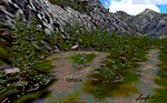
"Tongass Remote Airfield" (RATR) Alaskan scenery (Fictitious)
Tongass Remote Airfield is for Flight Simulator 2004 and for the "Tongass Fjords" (FS9) addon by Holger Sandmann & Bill Womack . You must have "Tongass Fjords" (FS9) for this to work.
Field history and description:
In the early days this area was well known to prospectors and hunters. A small mine was established and later abandoned. Around the late 40���¢��������s a crew was contracted to clear a small landing area to gain easier access for hunters and campers. Due to the extreme remoteness of this area that clearing took several years. The last phase was the approach, clearing by hand a descending glide slope through just the tops of the tall trees. There is now just enough room for a very experienced pilot to get in and out of this field. The airfield is 26 miles north of Petersburg Alaska (PAPG). This is a tricky narrow approach with a left hand dogleg and then an immediate right hand dogleg turn just before the final approach. Not much time to set up your approach, also, it's a very short runway. For experienced pilots only, and make sure that your life insurance is up to date. See enclosed Maps and info. Good luck.
| Filename: | Tongass_Remote_Airfield_RATR__for_Tongass_Fjords_F.zip |
| License: | Freeware, limited distribution |
| Added: | 11th February 2010, 00:49:22 |
| Downloads: | 625 |
| Author: | Jay Langham |
| Size: | 3.51 MB |
| Category: Flight Simulator 2004 - Scenery | |
| HLLQ El Beida/Labraq |
|
Images related to this file:
File Description:
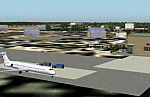
Googly scenery for HLLQ El Beida/Labraq - a joint civilian and military airport
near the north coast of Libya that is poorly provided for in Flight Simulator
2004. These scenery files add taxiways, aprons, buildings and other airport
features, so that you and your "AI" traffic can land, taxi, park and take off
in a realistic manner.
The city of Al Beida, or Al Bayda' or El Beda or Al Baidhah (depending on who
you are) has achieved its own airport status by using the end of a dead runway
at Labraq Air Base. In turn the airbase has contracted to use the opposite end
of the runway as its base of activity. The city is served by jets of Libyan
Airways and turboprop craft of Air One Nine and Ghadames Air Transport.
The scenery does not purport to be ultra-accurate. Based on high-detail satellite
imagery from Google Earth, the layout is proportionally correct but the added
airport features, such as buildings, are built from default Microsoft objects
and add-on libraries so will not look like the real thing.
You are not obliged to download and install any additional scenery libraries,
but to enjoy this scenery in its entirety, you may wish to. It will work fine,
with or without. [File re-uploaded at request of AVSIM]
| Filename: | HLLQ_El_BeidaLabraq.zip |
| License: | Freeware |
| Added: | 28th May 2010, 20:42:26 |
| Downloads: | 1,288 |
| Author: | John Hinson |
| Size: | 73.79 KB |
| Category: Flight Simulator 2004 - Scenery | |
| SKMD Medellin/Enrique Olaya Herrera, Colombia |
|
File Description:
Googly scenery for Medellin/Enrique Olaya Herrera (ICAO: SKMD, IATA: EOH). This
centrally located airport, named after the 1930 president of Colombia, was once
the only airport for the city of Medellin but most international flights are now
concentrated on the new international airport inconveniently situated 24 miles
away. Nevertheless the airport is very busy with domestic, charter and private
traffic and is regularly served by scheduled services of Aerolínea de Antioquia,
AIRES, Easyfly and SATENA. There are many charter operators based or serving
serving this airport, including Aexpa, Heliandes, Sarpa, Helicol and TAC; these
are mostly smaller aircraft or helicopter operations.
Remarkably for such an important airport, Microsoft have only provided a runway
at this airport in Flight Simulator 2004 and this scenery seeks to redress the
situation so that you and your "AI" traffic can use the airport realistically.
The scenery does not purport to be ultra-accurate. Based on high quality
satellite imagery from Google Earth, the layout is proportionally correct but the
added airport features, such as buildings, are built from default Microsoft objects
and add-on libraries so will not look exactly like the real thing.
You are not obliged to download and install any additional scenery libraries,
but to enjoy this scenery in its entirety, you may wish to. It will work fine,
with or without.
| Filename: | SKMD_MedellinEnrique_Olaya_Herrera_Colombia.zip |
| License: | Freeware |
| Added: | 6th December 2008, 10:22:40 |
| Downloads: | 2,568 |
| Author: | John Hinson |
| Size: | 388 KB |
| Category: Flight Simulator 2004 - Scenery | |
| CYPE - Peace River - Northwest Alberta, Canada |
|
Images related to this file:
File Description:
The Peace River flows east from the Rockies, joining up with the Slave River to empty into Great Slave Lake. The town is on both banks close to a bend, 245 miles northwest of Edmonton. The population is 7,000 and the surrounding area is either farmland or forest and used for winter sports; Peace River hosted the 2004 Alberta Winter Games. The airport is just over 3 miles west of the town. The runway is 5,000 feet of wide asphalt (150 feet) aligned 04/22, lit, and with PAPI. There is a second runway to the south of the main runway, 1,900 feet of grass and aligned 08/26. The apron is to the north of the runway at the eastern end and is large; there is a purpose-built terminal building, plus other hangar buildings along taxiway C that extends westward from the apron. The airport gives the impression that it is under-used; there are no long lines of parked planes waiting for the weekend and few scheduled flights. These are mainly (totally?) by Sunwest Home Aviation, but unfortunately nobody has made the textures for Sunwest and my talents do not run in that direction so I have made believable substitutions. There is also a small but obstinate AI difficulty, described in the notes.
| Filename: | CYPE__Peace_River__Northwest_Alberta_Canada.zip |
| License: | Freeware, limited distribution |
| Added: | 10th November 2013, 23:56:22 |
| Downloads: | 335 |
| Author: | Roger Wensley |
| Size: | 10.83 MB |
| Category: Flight Simulator 2004 - Scenery | |
| Scenery Objects - Rwy 12 scenery Level 2 |
|
File Description:
[File re-uploaded at request of AVSIM] This pack contains the standard scenery objects for the Rwy12 scenery generation program by Israel Roth and Seev Kahn and is specifically issued for the benefit of the end users of my add-on scenery series, although there is no reason why it will not work equally well with any other sceneries designed using this software. Most other designers have stated that the end user MUST download the massive 45 MB full program but this is not only pointless and unnecessary, it is not in accordance with the recommendations of Israel and Seev. Furthermore, the obligatory automatic installation programme is flawed and only works correctly if you have Flight Simulator 2004 installed to the default directory.
This pack of scenery objects addresses all of these issues, and all of my scenery sets will work with or without it - with three possible levels of scenery detail:
Level 1 - the airport scenery will only use Microsoft's default scenery objects (no extras require to be installed).
Level 2 - the airport scenery will additionally display all standard Rwy 12 scenery objects (Fedex vehicles, static GA aircraft, people and trees.
Level 3 - the airport scenery will additionally display third-party Rwy 12 objects.
The latter will require separate download and installation will be detailed in my scenery sets.
| Filename: | Scenery_Objects__Rwy_12_scenery_Level_2.zip |
| License: | Freeware |
| Added: | 20th June 2010, 10:35:15 |
| Downloads: | 12,948 |
| Author: | Israel Roth, Seev Kahn; compiled by John Hinson |
| Size: | 2.83 MB |
| Category: Flight Simulator 2004 - Scenery | |
| Bethel PABE in southwest Alaska |
|
Images related to this file:
File Description:
There are four main northwestern Alaska towns which have good airports and are serviced by Alaska Airlines. From these airports local flights connect to nearby villages, "nearby" in Alaska meaning up to 200 miles away. The northernmost is Barrow. Southwest of Barrow is Kotzebue, then Nome, and the furthest south is this one, Bethel. The town of Bethel has a population of just over 6,000 and is 50 miles from the sea on the Kuskowim River, that splits and forks into many tributaries. Bethel Airport is close to the town and provides the only contact with the rest of Alaska, as there is no connecting highway system. There are scheduled flights by Alaska Airlines, ERA (now called Ravn) and Grant Aviation, plus others such as Ryan Air. There are cargo flights by Everts, Northern, and Lynden, and redistribution onwards to nearby villages by the smaller locally-based planes; all of these are included in the AI. There are two main runways, one just under 6,400 feet and another just under 3,900 feet, both of them aligned 19-1. The third runway is around 1,800 feet and mainly gravel, aligned 11-29. Parking at PABE is on three aprons, the northern for smaller commercial planes of Grant, ERA, Ryan etc, the central for larger planes of Alaska, Northern, Everts, and Lynden, and the southern for a large collection of GA; each apron has further hangars for maintenance companies and smaller operators. There is also another separate apron for the local military and Coastguard. There is not much photographic information available for PABE, and I have never been there; as a result it was impossible to make detailed photographic textures for some of the buildings. However, for most hangars I have made textures of at least the right colour etc based on the information I assembled and if it is green with white trim and side windows then that is how it now appears here. The exceptions are the Alaska Airlines terminal building which has complicated curved elements, and the two military hangars and workshops where I had to settle for an Alaska terminal building from another airport and the same for the military. There are numerous small villages in the vicinity of Bethel, all of them being beside either a river tributary or the coast. There are two Google Earth screenshots to show the villages that are served by the flights from Bethel and that are (mostly) included in the AI. Some of these airfields were not included in FS9 but AI will still operate in and out of Bethel. The smaller area screenshot shows the villages that are close to Bethel, and of these eight I have so far made six and they are included in this post: Napaskiak PKA, Napakiak WNA, Kwethluk KWT, Atmautluak 4A2, Nunapitchuk 16A, and Kasigluk Z09. I will work my way through the rest of the area.
| Filename: | Bethel_PABE_in_southwest_Alaska.zip |
| License: | Freeware, limited distribution |
| Added: | 8th March 2019, 00:37:58 |
| Downloads: | 309 |
| Author: | Roger Wensley |
| Size: | 32.02 MB |
| Category: Flight Simulator 2004 - Scenery | |
| Sioux Lookout CYXL in northern Ontario, Canada, updated |
|
Images related to this file:
File Description:
This greatly modifies my previous post of Sioux Lookout; it is stand-alone and does not require you to have the 2009 version. The AI provided with the post complements what was included with Dryden (March 2013). Sioux Lookout is in northern Ontario, 40 miles east of Dryden, and 145 miles northwest of Thunder Bay. The town is on the northeastern shore of a lake that I don't know the name of (I've been there, but has anyone COUNTED how many lakes Canada has?). It has a population of around 5,000. The main businesses are lumber, tourism, and health care. The airport is immediately adjacent to the northeastern corner of the town, and has 5,300' of asphalt which is aligned 16-34. There are two taxiways which curve and climb up to the apron which is 20 or 30 feet higher. When you taxi on them the knowledge that in reality you would be climbing makes sense of the curved routing. The apron is large and a mixture of asphalt and gravel. I did not make the terminal building and I have no photo or even a recollection of what it looks like, so you should first install Northwest Ontario Airports by Eric O'Link as he has a terminal building for CYXL that might be how it looks; some of his airfields collide with other and newer versions and I have kept only his CYXL and CYPL bgl's.
| Filename: | Sioux_Lookout_CYXL_in_northern_Ontario_Canada_upda.zip |
| License: | Freeware, limited distribution |
| Added: | 19th March 2013, 19:23:24 |
| Downloads: | 405 |
| Author: | Roger Wensley |
| Size: | 5.08 MB |
| Category: Flight Simulator 2004 - Scenery | |
| CYKF – Kitchener / Waterloo, Ontario, Canada Version 3.0 |
|
File Description: I have now overhauled the CYKF Airport and made it the lively place it is today. I used the Canada Flight Supplement and my real life knowledge of the airport as this is where I do my flight training.
After seeing the traffic in my Southwestern Ontario addon, CYKF 2.1 looked a little bare in comparison, so added more parking and traffic. There are now 35 parking spots and 2 gates. All parking spots and gates have been assigned codes, which like the airline codes for the larger airports will tell the GA aircraft where to park. I organized the different aprons into parking areas. The Waterloo Wellington flight centre is referred to as “North” parking. There are 3 other parking areas as well as the gates. Traffic includes weekly scheduled aircraft that will fly up to the cottage or down south on the weekend etc.
• 35 parking spots, 2 gates
• Extended runway 25/07 and added the new taxiway and renamed the others
• Changed the landclass for the runway 25/07 extension
• Updated the airport in AFCAD for AI to use the runway 25/07 extension
• Added 22 AI flightplans to the 3 already there. AI will model real life training and commercial operations of the airport
• AI use proper Canadian registration codes
• Tested the files to make sure it operates correctly including AI
| Filename: | CYKF__Kitchener__Waterloo_Ontario_Canada_Version_3.zip |
| License: | Freeware, limited distribution |
| Added: | 14th November 2003, 19:39:31 |
| Downloads: | 2,751 |
| Author: | David Voogd |
| Size: | 1.06 MB |


© 2001-2026 AVSIM Online
All Rights Reserved
Privacy Policy |