
Where Flight Simulation Enthusiasts Gather from Around the World!
AVSIM Library - Search Results

| Category: Flight Simulator 2004 - Scenery | |
| Durham Tees Valley Airport |

|
File Description:
Situated in the UK, Durham Tees Valley Airport is a relatively small Regional Airport serving the North East with various European holiday destinations, Internal Domestic flights, and also has 2 General Aviation Clubs and Parking. Originally an RAF base, (as are most UK airports) It was used as an RCAF Bomber Command Station during WW2 with Lancaster's, Halifax's and Whitley's, then a Fighter Station after the war with Hunters, Javelins and English Electric Lightning’s. It was passed into civil hands in 1964 when the RAF left, Teesside Airport (as it was then know) was born.
| Filename: | Durham_Tees_Valley_Airport.zip |
| License: | Freeware, limited distribution |
| Added: | 10th June 2005, 16:56:21 |
| Downloads: | 7,073 |
| Author: | Stephen Legg |
| Size: | 8.63 MB |
| Category: Flight Simulator 2004 - Scenery | |
| Hay River - Merlyn Carter Airport NT |
|
Images related to this file:
File Description:
This scenery is the Hay River (CYHY)NT, Canada Airport located on the Southern side of Great Slave Lake. This small busy airport is an important part of the moving of freight and passengers to the North. During the spring and fall when the ice roads are not passable and the waterways cannot be used these Northern airports are vital to get the essential into Northern communities. Buffalo Airways is a great user of this airport for moving freight and passengers as well as operating a fleet of fire fighting tankers.
| Filename: | Hay_River__Merlyn_Carter_Airport_NT.zip |
| License: | Freeware, limited distribution |
| Added: | 28th April 2012, 03:32:22 |
| Downloads: | 1,083 |
| Author: | Flight Ontario - Al Gay |
| Size: | 26.09 MB |
| Category: Flight Simulator 2004 - Scenery | |
| Khasab International Airport, Musandam, Oman , version 2.0 |
|
Images related to this file:
File Description:

Khasab International Airport, is located in the far north of Oman. It is known for it's very tight approach, with a turn on final approach that comes close to Kai Tak. Situated within an hour flying time from both Muscat and Dubai, it is ideal for short flights with turboprops.The airport was opened as an Air Base in the mid-70s and has now also been in use for a couple of years for commercial flights. This is the FS2004 version. The FSX version will be available separately.
| Filename: | Khasab_International_Airport_Musandam__Oman__versi.zip |
| License: | Freeware |
| Added: | 11th February 2010, 13:20:33 |
| Downloads: | 3,601 |
| Author: | OryxSim |
| Size: | 7.19 MB |
| Category: Flight Simulator 2004 - Scenery | |
| Aberdeenshire |
|
File Description:
Scenery mods for the Aberdeenshire area of Scotland to be used with separate upload of Peterhead area. Includes revised North and South Esk and Ythan estuaries, and assorted lochs and lochans. Designed to be compatible with payware "Roads and Rivers of Europe" but will work to some extent without it. Also includes Hatton farm air-strip (X6HA) and an AF2 file. If you have RWY12 installed then this scenery mod will also give you Glens of Foudland windfarm and Sullom Voe oil storage tanks. Editvoicepack for "Hatton" included.
| Filename: | Aberdeenshire.zip |
| License: | Freeware |
| Added: | 28th March 2006, 03:24:55 |
| Downloads: | 2,269 |
| Author: | Paul Davidson |
| Size: | 1.72 MB |
| Category: Flight Simulator 2004 - Scenery | |
| Sultan Ismail Petra Airport - Kota Bharu, Malaysia |
|
Images related to this file:
File Description:

Sultan Ismail Petra Airport is located in north Malaysia and this is the much requested FS9 version. This has been a bit of a challenge due to the poor imagery of the area but we have certainly pushed the limits to bring you the best possible rendition of the airfield. Features include:
- Realistic ground image.
- High definition ground detailing.
- Illuminated taxiway centre light effect.
- Precision placed trees and vehicles.
- 3D approach lights.
- Low poly 3D grass.
- Customised AFCAD for improved AI.
- Realistic airport terminal building.
| Filename: | Sultan_Ismail_Petra_Airport__Kota_Bharu_Malaysia.zip |
| License: | Freeware, limited distribution |
| Added: | 25th July 2016, 20:13:45 |
| Downloads: | 1,562 |
| Author: | Mark Piccolo - Soarfly Concepts |
| Size: | 24.6 MB |
| Category: Flight Simulator 2004 - Scenery | |
| Zion National Park North, Cedar Breaks National Monument, Cedar City (KCDC), Utah, Photo-Scenery (FS9 & FSX) |
|
Images related to this file:
File Description:
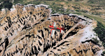
Cedar Breaks National Monument is a large amphitheater cliff in bright colors of red, orange and purple.
It lies east of Cedar City in the northern region of the scenery. The cliff was formed by erosion thru wind,
water and ice. Today erosion continues with a pace of about 2 inches every 5 years. Although it is called
Cedar Breaks, there are no cedars growing there but juniper trees. For a scenic flight to Cedar Breaks
National Monument best depart from Cedar City Regional Airport (KCDC) and head east. The scenery extends
south to Zion National Park and covers a large part of Zion Canyon and the Kolob Canyons area.
Zion National Park is another place where erosion of the Colorado Plateau formed the most beautiful colorful
stone formations of unique and wonderful shapes. There are nine different layers of stone visible in the park.
Most of them consist of sandstone. But there is also limestone, gypsum, siltstone, shale, clay and mudstone.
The Virgin River cut a spectacular and famous canyon thru Zion Park that is as narrow as 20ft and up to 2000ft tall.
High resolution versions of this scenery for FS9 and FSX (much sharper, but larger and multiple downloads)
are available at www.blueskyscenery.com/CNY_South2West5.html . The screenies are taken from the high-res versions,
so expect this version to be slightly more blurry.
Thanks to Joop Mak for providing a custom AFCADs that correct airport layouts so that they align with the photo-textures!
They are available here: www.blueskyscenery.com/AFCADs.html . YourDonation@Work: Dedicated to Richard, P.J. and Felix.
| Filename: | Zion_National_Park_North_Cedar_Breaks_National_Mon.zip |
| License: | Freeware, limited distribution |
| Added: | 14th March 2010, 00:30:28 |
| Downloads: | 1,564 |
| Author: | Gottfried Razek - blueskyscenery.com |
| Size: | 97.13 MB |
| Category: Flight Simulator 2004 - Scenery | |
| Dutch Harbour PADU in Alaska PLUS AI Air & Sea |
|
Images related to this file:
File Description:
This is a revised and much-added-to update of my earlier Dutch Harbor post, adding more Air & Sea AI. It is complete in itself and does not require you to have previously installed the original. New parking is for a civilian freighter, a Coast Guard C-130, and Coast Guard helicopters that fly from St Paul Island.
There is also a daily flight from Dutch Harbor to Akutan that will be by the amphibious Goose as there is no land runway at Akutan [more posts follow].
The official airport name is Unalaska, but a seat booked with airlines will be to Dutch Harbor, known from the tv series as a fishing centre with major fish and crab processing plants. In town the largest company is Unisea, taking up all of what was once Expedition Island and the adjacent shoreline. The out-of-town expansion is taking place along the shore of Captains Bay to the southwest, and here the largest is Westward with the uniform green roof for the plant and the residential buildings for seasonal workers.
The airport has just over 3,900 feet of 100 feet wide asphalt, aligned 30/12, lit, and between sea and hill with two aprons at the southeast end. There is no control tower at the airport, so don't be surprised when you are required to contact Cold Bay USAF for landing permission. Runway 30 has at its threshold a road; when a plane is landing or taking off traffic is stopped by barriers and lights. To encourage full use of the runway the fence is made up of plastic rods that bend on impact instead of chainlink topped with barbed wire that will turn a light plane upside down.
| Filename: | Dutch_Harbour_PADU_in_Alaska_PLUS_AI_Air__Sea.zip |
| License: | Freeware, limited distribution |
| Added: | 7th August 2012, 20:56:03 |
| Downloads: | 1,529 |
| Author: | Roger Wensley |
| Size: | 13.4 MB |
| Category: Flight Simulator 2004 - Scenery | |
| Alaska South Slope 4; Selawik PASK |
|
Images related to this file:
File Description:
There are four main northwestern Alaska towns which are serviced by Alaska Airlines, and from which local flights spread out. The northernmost is Barrow. Southwest of Barrow is Kotzebue, then Nome, and the furthest south is Bethel. This series is for the flights from and around Kotzebue, mostly on the South Slope of the Brooks Range of mountains. There will be further additions. Selawik is a village (population now around 760) around 75 miles east of Kotzebue on three of the delta islands of the Selawik River where it flows into Selawik Lake. The delta forms part of the Selawik National Wildlife Refuge for migratory birds. The airfield is just next to the village, with two runways, 3,450 feet of lit gravel aligned 03-21 and 3,100 feet of gravel aligned 09-27. There are scheduled flights by Era (now renamed Ravn) and by Bering Air, both of them originating in Kotzebue and routing east to Noorvik, Kiana, Selawik, etc, and then back again. The AI includes these flights along with Everts Air and GA.
| Filename: | Alaska_South_Slope_4_Selawik_PASK.zip |
| License: | Freeware, limited distribution |
| Added: | 9th October 2016, 04:17:52 |
| Downloads: | 212 |
| Author: | Roger Wensley |
| Size: | 4.34 MB |
| Category: Flight Simulator 2004 - Scenery | |
| Juneau, Alaska |
|
File Description:
A complete redesign of the airport for Juneau, Alaska (JNU, PAJN).
Version 1.0
This is a GPS position accurate layout of the runways (land and water), taxiways and signs, ramp, roads, buildings and nearby navaids.
The buildings are very close to accurate scale with close to accurate color.
There's parking spaces for small, medium and large general aviation aircraft, military cargo aircraft (Coast Guard C-130's and AK-NG aircraft park here), parking at the terminal for 737 and MD80 size aircraft and helicopter landing pads.
Also included is a terrain BGL for the immediate area. This is by far the largest file in the download, but is critical to accurately depict the surrounding terrain (see EORold and EORnew for a comparison).
Many details are yet to be added, but this is a good starting point.
| Filename: | Juneau_Alaska.zip |
| License: | Freeware, limited distribution |
| Added: | 17th August 2006, 13:48:08 |
| Downloads: | 6,030 |
| Author: | Russ Pagenkopf |
| Size: | 2.98 MB |
| Category: Flight Simulator 2004 - Scenery | |
| The Grenadines Islands Airports V1.1 for use with Antilles 2004 |
|
Images related to this file:
File Description:
This is a self-contained version V1.1 of the airports in the Grenadines chain of islands that I have already posted, modified for use with the Antilles 2004 scenery. I originally made them for stock FS9. The list is Hewanora, Saint Vincent, Bequia, Mustique, Canouan, Union Island, Carriacou, and Maurice Bishop International at the southern end of Grenada. The notes for V1.1 contain some information that should have been included in the first posting. The replacement scenery bgl's include some fixes to Antilles 2004 sea levels where the sea was climbing a hill, additional town landclass for the area close to the airport in Grenada as St Georges now stretches out along the coast, and some revisions to my airports where I found that installing on a second computer gave a slightly different and unsatisfactory result, in particular TVSB on Bequia.
| Filename: | The_Grenadines_Islands_Airports_V11_for_use_with_A.zip |
| License: | Freeware, limited distribution |
| Added: | 7th July 2013, 05:28:12 |
| Downloads: | 571 |
| Author: | Roger Wensley |
| Size: | 17.05 MB |
© 2001-2026 AVSIM Online
All Rights Reserved
Privacy Policy |