
Where Flight Simulation Enthusiasts Gather from Around the World!
AVSIM Library - Search Results

| Category: Flight Simulator 2004 - Scenery | |
| Paul Farm Field CF16 in Ontario, Canada |

|
Images related to this file:
File Description:
Paul Field is on the south side of Highway 174, four miles east of Hawkesbury Windover Field and five miles west of the town of Hawkesbury; the town is on the south bank of the Ottawa River approximately midway between Ottawa and Montreal. I first saw the field when I was on the way to Windover a few years ago. I asked some old timers at Windover who the grass strip belonged to and they said "Paul". It may not be what Paul calls it, but it's the only name I know it by. Probably Paul doesn't call it anything, it's just the field where he keeps his plane. There is a grass runway approximately north-south and 2,000 feet long, and two hangars which look to be an old one and a new one. In real life the runway isn't so north-south as it lines up with the farm fields alignment which is of course in FS is auto-generated and not actuality-accurate.
| Filename: | Paul_Farm_Field_CF16_in_Ontario_Canada.zip |
| License: | Freeware, limited distribution |
| Added: | 6th February 2010, 02:36:49 |
| Downloads: | 291 |
| Author: | Roger Wensley |
| Size: | 997.17 KB |
| Category: Flight Simulator 2004 - Scenery | |
| Fronconia NH 1B5 |
|
File Description:
This is my first attempt at making any kind of scenery for Flight Simulator. I live in Boston and love getting up into the White Mountains both in Summer and in Winter, so I decided to use my ultimate power of MSFS Eminent Domain and evicted the owners of this small private field right in the heart of the Presidential Range in order to create a fictionalized Pilot's home. It's nothing fancy, but it is a nice base for VFR flights throughout the region. We don't have the drastic vertical topography as many other places around the world here in New England, but I guarantee you that we have some of the prettiest, especially in the fall.
I hope you enjoy, and if you have any problems please e-mail me at [email protected]
Thanks,
John Combs
| Filename: | Fronconia_NH_1B5.zip |
| License: | Freeware |
| Added: | 28th June 2004, 16:05:56 |
| Downloads: | 489 |
| Author: | John Combs |
| Size: | 175.3 KB |
| Category: Flight Simulator 2004 - Scenery | |
| Burwash CYDB in Yukon Territory Canada |
|
Images related to this file:
File Description:
Burwash Landing is a very small village in the Yukon Territory, Canada, situated amid the Rocky Mountains at the northern end of Kluane Lake and some 30 miles from Silver City. The airfield, called just "Burwash" in the Nav Canada listing, is 2 miles northwest of the village and adjacent to the Alaska Highway. The runway is 5,000 feet of lit gravel aligned 10-19 and 130 feet wide, with VASI at each end. The date of this scenery is, as usual, around 2010. There is a company based at the airfield called Rocking Star Adventures, which is engaged in the same activity as the other companies at Haines Junction and Silver City, ie taking tourists around the glaciers of Kluane National Park. The park is very imressive from the air. The Ai was included with the Haines Junction post.
| Filename: | Burwash_CYDB_in_Yukon_Territory_Canada.zip |
| License: | Freeware, limited distribution |
| Added: | 22nd January 2022, 21:57:47 |
| Downloads: | 119 |
| Author: | Roger Wensley |
| Size: | 11.24 MB |
| Category: Flight Simulator 2004 - Scenery | |
| Gjoa Haven CYHK, on King William Island, Nunavut, Canada, |
|
Images related to this file:
File Description:
Gjoa Haven is a village of 1,200 or so inhabitants at N 68 38 W 95 51 on the southeast corner of King William Island, around 155 miles north of the Arctic Circle. It's Inuit name is Uqsuqtuuq; the Gjoa Haven name was given by the Norwegian explorer Roald Amundsen when he spent two years there from 1903 to 1905 during his exploration of the northwest passage from east to west. His boat was called Gjoa and the cove was named Gjoa Harbour, in Norwegian. The village has been added in this scenery with approximately the right shape; though the coastline with Ultimate Terrain does have the small cove that serves as a harbor the coast shape is wrong. The airfield runway is 4,400 feet of gravel 100 feet wide at 154 feet above sea level. There is no LL100 available, only JetA1, delivered once a year by ship along with all the other requirements of the town. There is also a nearby CAM-B remotely operated defence radar station with its three protective domes. The old terminal building is still there, albeit repainted and spruced up, along with the far larger and newer one alongside it.
One of the screen shots shows Gjoa Haven as it appears for at least 8 months of the year, with snow on the ground and sea ice all around. If you want the ice then download my recent post of All Canada frozen lakes, rivers, and the northern seas, reversible with an untick in the FS scenery library.
| Filename: | Gjoa_Haven_CYHK_on_King_William_Island_Nunavut_Can.zip |
| License: | Freeware, limited distribution |
| Added: | 19th February 2011, 15:42:51 |
| Downloads: | 550 |
| Author: | Roger Wensley |
| Size: | 2.68 MB |
| Category: Flight Simulator 2004 - Scenery | |
| UK missing Navaids and Northsea NDB's |
|
File Description:
FS2004 missed a few UK Navaids. I have made up this BGL file to include them and also added some NDB's for the North Sea. The UK navaids have been checked and the civil ones are listed in the UK air pilot as current. The other naviads taken from an older official reference but I was unable to check their current status. A txt file has been included giving their Lat/Long, Freqs and Idents.
| Filename: | UK_missing_Navaids_and_Northsea_NDBs.zip |
| License: | Freeware |
| Added: | 31st August 2003, 00:31:47 |
| Downloads: | 2,130 |
| Author: | Ron King |
| Size: | 5.81 KB |
| Category: Flight Simulator 2004 - Scenery | |
| 0JER Estate |
|
File Description:
0JER is a private airport and estate located on the The North Shore of Lake Superior in Northern Wisconsin. Any plane from light single engine to a heavy 747 can land on its 10,000ft runway. Parking for 4 heavy jets and 2 for med or smaller. 2 Hangers, control tower, mansion. Enjoy landing your private BBJ at your own private estate and airport in a beautiful location. Requires that you have RWY12.
| Filename: | 0JER_Estate.zip |
| License: | Freeware |
| Added: | 4th December 2008, 23:38:11 |
| Downloads: | 419 |
| Author: | Jeremy Hoveland |
| Size: | 7.24 KB |
| Category: Flight Simulator 2004 - Scenery | |
| Imperial War Museum, Duxford |
|
Images related to this file:
File Description:

IWM Duxford, UK. Just about the definitive representation of the Imperial War Museum, Duxford you could wish for.
Includes comprehensive photo-realistic buildings and structures on both the north and south sides of the airfield, photo ground tiles and it is fully customisable from a quite day through to an optional air show add-on. Complete with a package of 20 custom built classic AI aircraft. By Airfield Construction Group (ACG).
| Filename: | Imperial_War_Museum_Duxford.zip |
| License: | Freeware, limited distribution |
| Added: | 5th November 2011, 19:56:08 |
| Downloads: | 5,078 |
| Author: | John Young, Stephen Legg, ACG |
| Size: | 59.02 MB |
| Category: Flight Simulator 2004 - Scenery | |
| Multinational Force and Observers |
|
Images related to this file:
File Description:
This project brings to life the Multinational Force and Observers North Camp at El Gorah AB (HEGR) and South Camp near Sharm El-Sheikh. Included are scenery for both camps, FS9 tested flight plans as well as FS9 and FSX repaints for the UH-60s of the US Army Task Force Sinai 1st Support Battalion using John Youngs AI UH-60. Please see the readme file for a list of required scenery libraries.
| Filename: | Multinational_Force_and_Observers.zip |
| License: | Freeware |
| Added: | 1st October 2015, 08:36:28 |
| Downloads: | 314 |
| Author: | Brent Newman |
| Size: | 4.79 MB |
| Category: Flight Simulator 2004 - Scenery | |
| Pittsburgh KPIT / PIT, version 1.1 |
|
Images related to this file:
File Description:

Thank you for downloading my scenery. This file contains a complete remake for Pittsburgh Int'l Airport. It includes remodeled and repositioned terminals, jetways, and vehicles. All terminals have accurate parking assignments per the PIT website as a feature of the included AFCAD. This scenery was built using Abacus' EZ-Scenery program.
Update:
Version 1-1 fixes a small error which eliminated several taxiway signs on the North side of the airport.
| Filename: | Pittsburgh_KPIT__PIT_version_11.zip |
| License: | Freeware |
| Added: | 30th May 2010, 10:26:36 |
| Downloads: | 7,696 |
| Author: | William Morgan, FRFSTUDIO.NET |
| Size: | 1.86 MB |
| Category: Flight Simulator 2004 - Scenery | |
| Valle D'Aosta part 2 (West), Alps, Italy, Photo Real |
|
Images related to this file:
File Description:
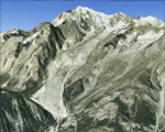
The scenery covers the western portion of the Valle D'Aosta, North Italy, Alps. The Photo Real Scenery is wide for around 2100 squared Kms. The airport of Aosta (ICAO code LIMW) is found inside the scenery (see map). The complete scenery of the valley was divided in 2 parts to fit the 100Mb file space limit: part 2 (this file) and part 1 (est side see AVSIM library - valle_aosta_est_vfr.zip). For FSX and FS9.
| Filename: | Valle_DAosta_part_2_West_Alps_Italy_Photo_Real.zip |
| License: | Freeware |
| Added: | 2nd June 2010, 13:22:39 |
| Downloads: | 14,697 |
| Author: | Fulvio Mazzokan |
| Size: | 58.15 MB |
© 2001-2026 AVSIM Online
All Rights Reserved
Privacy Policy |