
Where Flight Simulation Enthusiasts Gather from Around the World!
AVSIM Library - Search Results

| Category: Flight Simulator 2004 - Scenery | |
| Essex County Airport (KCDW) |

|
Images related to this file:
File Description:
FS2004 Scenery - Essex County Airport (IATA: CDW, ICAO: KCDW, FAA LID: CDW) is a public airport located two miles (3 km) north of the central business district of Caldwell, a borough of northwestern Essex County in the U.S. state of New Jersey. It is owned by the Essex County Improvement Authority. The airport has two asphalt runways, 4/22 and 10/28. Created by John B. Loney, Jr.
| Filename: | Essex_County_Airport_KCDW.zip |
| License: | Freeware, limited distribution |
| Added: | 4th April 2012, 03:26:13 |
| Downloads: | 456 |
| Author: | John B. Loney, Jr. |
| Size: | 19.69 MB |
| Category: Flight Simulator 2004 - Scenery | |
| TLPC - George F. L. Charles Airport - Saint Lucia |
|
Images related to this file:
File Description:
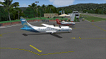
George F. L. Charles Airport IATA: SLU, ICAO: TLPC - is the smaller of two airports in Saint Lucia, the other being Hewanorra International Airport. It is located 2 km (1.2 mi) north of Castries, the capital city. George F. L. Charles Airport is managed by the Saint Lucia Air and Seaports Authority (SLASPA). Its runway runs parallel to a pristine beach, Vigie Beach, which is a popular tourist attraction.
| Filename: | TLPC__George_F_L_Charles_Airport__Saint_Lucia.zip |
| License: | Freeware |
| Added: | 25th August 2013, 21:18:44 |
| Downloads: | 1,310 |
| Author: | Delblond Christian |
| Size: | 9.6 MB |
| Category: Flight Simulator 2004 - Scenery | |
| Real Terrain: New Mexico |
|
File Description:
Now included with the download is a map that shows the highest and lowest points of New Mexico. Also included is a sectional map of New Mexico, split into the north and south half of the state. Whats new to this release of Real Terrain is manual install. Due to requests, I have not made a Auto Installer. For more infor mation Please go to my website realterrain.bravehost.com.
| Filename: | Real_Terrain_New_Mexico.zip |
| License: | Freeware, limited distribution |
| Added: | 7th May 2004, 06:47:14 |
| Downloads: | 2,676 |
| Author: | David P Smith |
| Size: | 55.73 MB |
| Category: Flight Simulator 2004 - Scenery | |
| MMQT Queretaro, Qro. Mexico, Ing. Fernando Espinoza Gutierrez |
|
Images related to this file:
File Description:
New MMQT, Final version, updated and with AFCAD, thanks to John Hinson.This is the new MMQT airport, its about 10 nautical miles to the north of the older MMQT, larger runway, the airport its about 20 minutes by car from Queretaro city, Look at VOR 113.00,Enjoy the new addon scenery MMQT Queretaro International Airport, Mexico, the old one MMQT is closed now... Any comments please email me.
| Filename: | MMQT_Queretaro_Qro_Mexico_Ing_Fernando_Espinoza_Gu.zip |
| License: | Freeware |
| Added: | 31st May 2010, 11:49:18 |
| Downloads: | 2,555 |
| Author: | Arturo Garcia XE1AT |
| Size: | 1.12 MB |
| Category: Flight Simulator 2004 - Scenery | |
| EDCP Peenemunde Military Airfield, Germany |
|
Images related to this file:
File Description:
Peenemünde Airfield, Germany. The airfield Peenemunede is the one field of a row of military airfield sceneries of the former NVA. In the scenery are included the airfield and the technical supplies. The airfield was put into operation in 1961 in duty of the NVA. He accommodated the 9th fighter wing with Mig-21 and MiG-23. It is located along the Baltic Sea north of Peenemünde, Germany.
| Filename: | EDCP_Peenemunde_Military_Airfield_Germany.zip |
| License: | Freeware |
| Added: | 8th August 2011, 16:45:21 |
| Downloads: | 1,015 |
| Author: | Volker Loew, Rolf-Uwe Hochmuth, Frithjof Koch |
| Size: | 6.43 MB |
| Category: Flight Simulator 2004 - Scenery | |
| Canadian and Northern USA Winter Flying |
|
File Description:
This is an expanded version of a previous post a year ago, and stretches from east of Quebec City through Quebec, Ontario, and Manitoba, and now also through Saskatchewan, and into Alberta (past Calgary). There is also a northern area roughly centered on Hudson Bay. The exact coverages are given in the notes. All rivers and lakes within the area will "freeze" and allow ski planes to land, or even wheeled planes come to that. And it is not permanent, when you want to go back to floats just "untick" it in the FS library, and it will melt. The area covered crosses into the US too, down to around 45 degrees north, so that means most of Montana, all of North Dakota, half of Minnesota, and some of Wisconsin, Michigan etc. It seemed silly to stop at the border. Ultimate Terrain is highly recommended, so that there will actually be the right lakes and rivers ready to freeze.
| Filename: | Canadian_and_Northern_USA_Winter_Flying.zip |
| License: | Freeware |
| Added: | 26th May 2008, 13:24:29 |
| Downloads: | 669 |
| Author: | Roger Wensley |
| Size: | 354.86 KB |
| Category: Flight Simulator 2004 - Scenery | |
| Calcinate del Pesce, Italy |
|
Images related to this file:
File Description:
Calcinate del Pesce is a small gliders airport placed on Varese lake, approx 25 miles north-west Milan Italy, closed to the Prealpi hills. North of the hills around you can find towers and observer of Campo dei Fiori meteo station. The airport is also base of Elilombarda, helicopter-rescue. Contents: Grass runway placed approx on the real coordinates, with ILS and taxi ways; five different hangars and fast food on the entrance; 10 gliders parked on the ground, several glider boxes all around the airport; a lot of trees around the scenery and lights on parking, gliders and road areas; wind sign, static Cessna, fuel station, people and cars; bird storm floating in the air; complete fences on all the airport perimeter with opening gate; two helicopters on ground and a Coca Cola balloon; small pier in the lake with dinghy; Varese open footbal stadium, close sport building and cathedral (fiction); Campo dei Fiori fantasy scenery with observe and comunication towers
| Filename: | Calcinate_del_Pesce_Italy.zip |
| License: | Freeware |
| Added: | 16th February 2011, 15:34:22 |
| Downloads: | 767 |
| Author: | Aldo Della Vedova |
| Size: | 12.28 MB |
| Category: Flight Simulator 2004 - Scenery | |
| Yellowknife Floats CEN9 - Northwest Territories, Canada |
|
Images related to this file:
File Description:
Yellowknife float base is on the shore of Yellowknife Bay, which is on the north side of Great Slave Lake. The float base is on two sides of Latham Island and the promontory that reaches out to it, which is where the town of Yellowknife was originally founded, and float planes land either in Back Bay (to the west) or in East Bay (guess where?). Where the south end of the island meets the promontory there are two inlets and two companies; Air Tindi in the eastern part and North Airways in the western. These two companies have bespoke buildings. I have used other buildings from other sceneries to model the "feel" of the original Yellowknife and the docks along the shore. One thing I could not do, and that was to recreate at its correct height "the rock", which is the raised centre of the promontory; FS9 resisted terrain readjustments beyond a certain point.
| Filename: | Yellowknife_Floats_CEN9__Northwest_Territories_Can.zip |
| License: | Freeware, limited distribution |
| Added: | 1st February 2012, 23:53:17 |
| Downloads: | 917 |
| Author: | Roger Wensley |
| Size: | 12.38 MB |
| Category: Flight Simulator 2004 - Scenery | |
| CWCP - Cape Parry - Northwest Territories, Canada |
|
Images related to this file:
File Description:
This is a DEW line Main Station on the shore of the Canadian mainland at the far northern tip of Cape Parry. It is 60 miles north of Paulatuk, which is at the base of the Parry Peninsula, and 120 miles south of Sachs Harbour on Banks Island. The station ceased operations in 1989 and a North Warning System automated station was opened in the same year; the NWS station is not shown in this scenery as I have no information regarding it's location or layout. The runway is just over 5,000 feet of gravel 150 feet wide, aligned 037T at an elevation of 119 feet ASL. There is a large apron with a large hangar and a small shelter building for passengers. There are of course no lights, signage, or windsock. The station is up on the hill at 210 feet ASL. This is one of the more interesting stations in terms of size and complexity.
| Filename: | CWCP__Cape_Parry__Northwest_Territories_Canada.zip |
| License: | Freeware, limited distribution |
| Added: | 25th December 2012, 19:07:24 |
| Downloads: | 302 |
| Author: | Roger Wensley |
| Size: | 1.61 MB |
| Category: Flight Simulator 2004 - Scenery | |
| Maniwaki CYMW in Ontario Canada |
|
Images related to this file:
File Description:
Maniwaki airfield is seven miles south of the town of Maniwaki and some 60 miles north of Ottawa, up the Gatineau River. There is a generous 5,000 feet of runway 03/21 that is 150 feet wide and in bad condition, so bad that there are now almost no markings of any sort (even a centre line, the apron has more paint than the runway!) and the whole lot is going to be redone next summer. The apron is large, and in the summer accomodates two Bombardier CL 415 fire fighting amphibians, which is why there is a large access platform loitering on the apron. There are only five hangars on the field with another one tucked into the trees behind a house. The hangars and the office/cafe building have been modelled specifically for this field. There are further buildings to the north which are not actually on the airfield and which house fire department personnel.
| Filename: | Maniwaki_CYMW_in_Ontario_Canada.zip |
| License: | Freeware, limited distribution |
| Added: | 14th February 2010, 23:12:27 |
| Downloads: | 505 |
| Author: | Roger Wensley |
| Size: | 4.56 MB |
© 2001-2026 AVSIM Online
All Rights Reserved
Privacy Policy |