
Where Flight Simulation Enthusiasts Gather from Around the World!
AVSIM Library - Search Results

| Category: Flight Simulator 2004 - Scenery | |
| Idaho County S80 Airport |

|
File Description:
Another small airport in beautiful Idaho. Near the mountains but not in them, this airport offers easy access and 24 hour operation. The airport NOTAM mentions skydiving activity, so I'm guessing the large circular dirt area is a landing target for the skydivers. All aprons were redrawn and buildings replaced according to better match Google Earth images. The landclass was modified to reduce the nearby city to a more realistic size and replace the farmland surrounding the airport.
This scenery was designed for Ultimate Terrain and may or may not work with the default scenery.
| Filename: | Idaho_County_S80__Airport.zip |
| License: | Freeware |
| Added: | 27th July 2008, 11:51:45 |
| Downloads: | 494 |
| Author: | Sidney Schwartz |
| Size: | 651.96 KB |
| Category: Flight Simulator 2004 - Scenery | |
| Emsdale CNA4 & Emsdale South fields in Ontario, Canada |
|
Images related to this file:
File Description:
Emsdale is on Hwy 11 about midway between North Bay and Lake Simcoe. A mile north of the town is Emsdale airfield CNA4, with two grass runways that are 12/30 2,500 feet long, and 17/35 2,000 feet long. There is only one hangar, no fuel, and in general there does not appear to be a lot of action. "Grass" may be a generous description of the runway surface, particularly for 12/30.
The second field is two miles southwest of Emsdale and privately owned. It has 2,700 feet or so of asphalt runway and a parallel grass runway (which is short at under 800 feet, plus a hangar at the north end!). There are six buildings, between hangars and office or club house and that about sums up all I know about it. If anyone knows more about this field please let me know.
| Filename: | Emsdale_CNA4__Emsdale_South_fields_in_Ontario_Cana.zip |
| License: | Freeware |
| Added: | 3rd February 2010, 15:35:35 |
| Downloads: | 390 |
| Author: | Roger Wensley |
| Size: | 1.91 MB |
| Category: Flight Simulator 2004 - Scenery | |
| Torrey, Box-Death Hollow Wilderness, Aquarius Plateau, Utah, Photo-Scenery (FS9 & FSX) |
|
Images related to this file:
File Description:
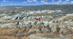
The southern part of this region covers the Box-Death Hollow Wilderness, with its vertical gray-orange walls of Navajo sandstone. Then comes the Aquarius Plateau which is the highest timbered plateau in North America with Boulder Mountain. In the north you'll find the little town of Torrey, which is just eight miles west of Capitol Reef National Park. Extends my Grand Staircase Escalante scenery to the north.
High resolution versions of this scenery for FS9 and FSX (much sharper, but larger and multiple downloads) are available at www.blueskyscenery.com/CNY_SouthWest3.html . The screenies are taken from the high-res versions, so expect this version to be slightly more blurry.
Thanks to Joop Mak for providing a custom AFCADs that correct airport layouts so that they align with the photo-textures! They are available here: www.blueskyscenery.com/AFCADs.html . YourDonation@Work: Dedicated to Ralf-Peter, Jon and Laurent.
| Filename: | Torrey_BoxDeath_Hollow_Wilderness_Aquarius_Plateau.zip |
| License: | Freeware, limited distribution |
| Added: | 3rd April 2010, 00:52:09 |
| Downloads: | 1,200 |
| Author: | Gottfried Razek - blueskyscenery.com |
| Size: | 93.79 MB |
| Category: Flight Simulator 2004 - Scenery | |
| New York City Default Bridges and Objects v2.0 |
|
File Description:
I originally planned on "fixing" the George Washington Bridge, which was inadvertantly "sunk" by FSG's 38m mesh, and ended up repositioning and scaling a whole bunch of other default bridges and objects within about 50 miles of NYC. This addon was designed and tested for use with FS 9.1, FSG 38m mesh (available here at AVSIM), and Freeflow NE, UT/USA and USA Roads. It should also work with other road and water packages. I did not create any new scenery, I only repositioned default objects to their correct locations.
This should be the final version for a while. This version was tested with and adds compatibility for Megascenery NY and Aerosoft's Manhattan scenery. I also removed a few more objects that were placed in the water, and moved back to land a bunch of cranes around KEWR that were in the water.
Fixed stuff: All inappropriately placed NYC and Newark bridges (major, not autogen) up to Bear Mountain in the north and south to about the Verrazanno; Belmont Racing track; Shea Stadium; Meadowlands Stadium; World's Fair Tower; US Open Stadium. Added Meadowlands Race track and a few bridges around Newark, moved cranes around KEWR back to land, removed several objects in the water.
| Filename: | New_York_City_Default_Bridges_and_Objects_v20.zip |
| License: | Freeware |
| Added: | 10th November 2005, 16:48:46 |
| Downloads: | 6,556 |
| Author: | Thomas Perry |
| Size: | 558.69 KB |
| Category: Flight Simulator 2004 - Scenery | |
| Canavese photoreal scenery |
|
File Description:
The scenery cover an area of 1200 km^2 in Piemonte, north of Italy. The scenery center is Ivrea, world famous for the Olivetti industries. The 60% of the entire area is covered with autogen. No seasonal texture.
| Filename: | Canavese_photoreal_scenery.zip |
| License: | Freeware |
| Added: | 2nd December 2005, 00:21:14 |
| Downloads: | 5,588 |
| Author: | Michele Sempronio |
| Size: | 28.92 MB |
| Category: Flight Simulator 2004 - Scenery | |
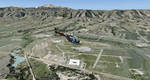
| PAAQ - Palmer Muni - Anchorage, Alaska - USA |
|
Images related to this file:
File Description:
Palmer PAAQ is in Alaska, some 40 miles northeast of Anchorage on the north side of Knik Arm and beside the west bank of the Matanuska River. It is for both GA and commercial aircraft. There are two apron areas, north and south, separated by the east-west runway. The north apron is for the Forestry Service planes and for resident GA tie-down places and hangars, along with maintenance facilities; the southern end of the north apron is for itinerant aircraft. The south apron is almost entirely for commercial companies and again maintenance. The main runway is just under 6,000 feet long, aligned L16-R34 and asphalted and lit, as is the parallel taxiway A. There is also a shorter and parallel runway that is grass and which receives no winter maintenance. The second main runway is 3,600 feet long and aligned 09-27, asphalt and lit and with a parallel taxiway B, also lit. The airport is undergoing a process of upgrading, which explains the varied colours (and age) of resurfaced taxiways. There are adjustment bgl's for two other neighbourhood airstrips, Toad Lake 24AK and Wolf Track 9AK8, which I just discovered buried in nearby holes in the ground; I also revised their runway surfaces.
| Filename: | PAAQ__Palmer_Muni__Anchorage_Alaska__USA.zip |
| License: | Freeware, limited distribution |
| Added: | 4th November 2014, 00:01:43 |
| Downloads: | 446 |
| Author: | Roger Wensley |
| Size: | 22.35 MB |
| Category: Flight Simulator 2004 - Scenery | |
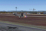
| KILM - Wilmington International Airport - Wilmington, North Carolina (USA) |
|
File Description:
Wilmington International Airport for FS9
John B. Loney, Ray Lunning and Michael Verlin
This Airport started out to be a simple stand alone rendering of the public terminal at KILM. Michael and I entered into a correspondence about this when it became evident that Ray Lunning had designed KILM as a complete airport in 2007. This ended in a collaboration by the three authors. Ray Lunning graciously agreed to allow the use of his original files. Michael Verlin contributed additional input and testing to complete the integration of the various components.
As usual, I welcome any comments. I will try to answer as many as I can.
E-Mail: Website:
[email protected] www.lfssd.net
Have fun and enjoy.
| Filename: | KILM__Wilmington_International_Airport__Wilmington.zip |
| License: | Freeware, limited distribution |
| Added: | 19th August 2013, 17:01:00 |
| Downloads: | 835 |
| Author: | John B. Loney, Ray Lunning and Michael Verlin |
| Size: | 3.18 MB |
| Category: Flight Simulator 2004 - Scenery | |
| Colorado Springs North, Colorado, Photo-Scenery (FS9 & FSX) |
|
Images related to this file:
File Description:
This region covers the area between Denver and Colorado Springs. It extends my Denver scenery to the south.
Just north of Colorado Springs you can see the widespread United States Air Force Academy which, with it's
many buildings, covers a huge area of 18.000 acres. The Academy Airfield (KAFF) which lays in the northeastern
corner of the area is used for training cadets in airmanship courses, including parachute training,
soaring and powered flight.
High resolution versions of this scenery for FS9 and FSX (much sharper, but larger and multiple downloads)
are available at www.blueskyscenery.com/GNB_South2East.html . The screenies are taken from the high-res versions,
so expect this version to be slightly more blurry. YourDonation@Work: Dedicated to Robin and Raymond.
| Filename: | Colorado_Springs_North_Colorado_PhotoScenery_FS9__.zip |
| License: | Freeware, limited distribution |
| Added: | 3rd February 2010, 02:09:59 |
| Downloads: | 2,186 |
| Author: | Gottfried Razek - blueskyscenery.com |
| Size: | 96.91 MB |
| Category: Flight Simulator 2004 - Scenery | |
| Prudhoe Bay area on Alaska North Slope US |
|
Images related to this file:
File Description:
The Prudhoe Bay area of the Alaska north slope is dominated by all the equipment and machinery that is necessary for the extraction of oil and its transfer by the pipeline that reaches south to Valdez. Prudhoe Bay airport is now closed, and its replacement just to the south is Deadhorse PASC, with numerous storage, maintenance, and accomodation areas immediately to the north of the apron, and others adjacent to the road between the two. The runway is just under 6,500 feet with approach lights at both ends and ILS on 04 (true heading of 75 degrees). This scenery reflects the overall situation in 2011 and oil production facilities and buildings are included here. The airport buildings and those close to the airport are replicas of the real life buildings; while as distance increases the accuracy fades somewhat there are everywhere replica trucks and cross country vehicles that are true to life. Deadhorse handles around 7,000 passengers per month as staff are rotated in and out on Alaska Air and ERA flights and by oil company private flights. There are also freight flights to complement the trucking effort up the Dalton Highway. The Alaska Airlines terminal building and ERA (the red buildings nearby) are at one end of the apron, while at the other end is a very large and new green terminal, storage, hangar building built by the airport authority. All of the airport components, runways, taxiways, and aprons, are built up on a gravel base to raise them above the surrounding terrain that floods with melting snow, freezes, or dries out, according to the seasons. There are other new airstrips included here that serve the oil industry. Around 33 miles to the east is Badami PABP airport servicing a subsiduary oil producing area, with 5,000 feet of gravel runway. Some 28 miles to the west of Deadhorse is Ugnu-Kuparuk UBW with just over 6,000 feet of gravel (gravel in 2011, it is now asphalted) servicing oil production by Conoco Phillips, which uses 737's to fly staff in and out. A further 32 miles west is Alpine AK15 with 5,400 feet of gravel and also served by the Conoco Phillips 737's. To the south of Alpine and connected by road is the village of Nuiqsut. To the north of Alpine and reachable only by air in the delta of the Sagavanirktok River is CD-3, an oil collection and pump station area with another gravel runway of 3,000 feet. Other airstrips that were prviously posted are now updated, Nuiqsut and Oliktok. I experimented, but decided against trying to reproduce the several hundred miles of pipelines. The are new AI aircraft, and there are notes regarding downloading. There is a new "cement" texture (not its name, but used as that by SBuilder) for the built up gravel bases. It is slightly darker than the original but not so much that any previous use will be spoilt. You may wish to download my "Alaska Frozen Rivers and Lakes" which freezes lakes and the northern sea and makes them landable on wheels.
| Filename: | Prudhoe_Bay_area_on_Alaska_North_Slope_US.zip |
| License: | Freeware, limited distribution |
| Added: | 19th December 2017, 00:38:06 |
| Downloads: | 583 |
| Author: | Roger Wensley |
| Size: | 28.54 MB |
| Category: Flight Simulator 2004 - Scenery | |
| Cameri and Turbigo sceneries (rev. 3) - north Italy |
|
Images related to this file:
File Description:
The following files are required by this file:
http://library.avsim.net/esearch.php?DLID=163723&UploadID=&Name=&FileName=&Author=&CatID=root
http://library.avsim.net/esearch.php?DLID=186350&UploadID=&Name=&FileName=&Author=&CatID=root
This scenery includes a global review of the previous Sceneries of Cameri Military airport (rev.2 Oct 2011), Cameri Museum (rev. 2 Oct 2011), Cameri Babini (rev. 2 oct 2011), Turbigo power station (rev. 2 Sep 2011 and update rev. 2.1 Oct 2014). All the above ARE NOW INCLUDED in this new unique scenery. Contents: Terrain in new version photo-realistic multi-seasons/night; adapted to Western Europe special elevation meshes; cover area of over 120 sqkm from Bellinzago-Oleggio (NW) to Magnago-Bienate (NE), from Novara (SW) to Cuggiono-Inveruno (SE); all the terrain has been restorated with 3D buildings, either through autogen that with specific dedicated objects (by GMax) and with significant addition of library objects ("dva51" and other existings). This scenery (located on the final approach to the Milan Malpensa international airport) includes the Cameri's Mil Airport with the Babini closed Army area and the planes of the Historical Museum of the airport; it is also included the thermoelectric power station of Turbigo. All the buildings are placed to recreate cities and villages covered in the photo-realistic terrain, including Bellinzago, Bienate, Buscate, Caltignaga, Cameri, Castano Primo, Castelletto Ticino, Cuggiono, Galliate, Inveruno, Magnago, Malvaglio, Nibbia, Novara, Oleggio, Pernate, Robecchetto, Romentino, Sant'Anna, San Pietro Mosezzo, Turbigo , Vanzaghello, and the covered Turin-Milan highway.
Details of the new buildings for the care and maintenance to F35 completely recreated, as obtainable from the current satellite view.
It REQUIRES the use of the following, to be downloaded separately :
- the libraries dva51 - the system of vegetations TreePlanter - the West Europe Meshes of Daniele Lanfranchi. See the Readme file. Enjoy!
Videos available here:
https://dl.dropboxusercontent.com/u/38829151/FS9/Cameri_Turbigo_v3%20shots.WMV
http://youtu.be/yVI2KeJKS5o
http://youtu.be/oKa0e_5kxIk
| Filename: | Cameri_and_Turbigo_sceneries_rev_3__north_Italy.zip |
| License: | Freeware |
| Added: | 21st January 2015, 21:32:36 |
| Downloads: | 990 |
| Author: | Aldo Della Vedova, Daniele Lanfranchi and Gian Mario Verga |
| Size: | 103.7 MB |
© 2001-2026 AVSIM Online
All Rights Reserved
Privacy Policy |