
Where Flight Simulation Enthusiasts Gather from Around the World!
AVSIM Library - Search Results

| Category: Flight Simulator 2004 - Scenery | |
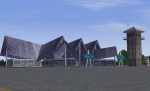
| Shaktoolik 2C7 in Alaska |

|
Images related to this file:
File Description:
Shaktoolik is a coastal village 35 miles north of Unalakleet, with a fishing population of around 250. It was originally established inland on the Shaktoolik River but moved to the coast in 1933. Due to storms and erosion it was again moved in 1967, to its current location 2 miles further north. Confusingly, what is called "New Shaktoolik 38A" was in fact only "new" in 1967 and has since been replaced by "Shaktoolik 2C7" further north, built on wider land with a longer gravel runway of 4,000 feet. 38A is still visible but unusable, with the sheds being used for other purposes. There are flights from Unalakleet, included in the AI here as a further modification to the Bethel PABE AI. A note here about my scenery making. This is post number 500 and there will not be many more to follow this as I am almost at the end of the photos I either took or found for scenery purposes. There is a limit to what can be located online and I have already been making use of the little there is; eg Unalakleet. So, if you are near an airport (preferably Canadian or Alaskan) and have a camera..... Let me know.
| Filename: | Shaktoolik_2C7_in_Alaska.zip |
| License: | Freeware, limited distribution |
| Added: | 27th July 2019, 21:00:56 |
| Downloads: | 105 |
| Author: | Roger Wensley |
| Size: | 4 MB |
| Category: Flight Simulator 2004 - Scenery | |
| Northern Canada Mining CYOA & CHB3 in Canada |
|
Images related to this file:
File Description:
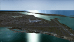
These are two airfields in northern Canada, serving two mining operations. The furthest north is Hope Bay CHB3 in Nunavut. It is in a sheltered inlet less than 3 miles from the northern mainland coast and around 65 miles southwest of Cambridge Bay. The owner is Hope Bay Mining Ltd, and their operation mines gold out of a tunnel rather than open cast. The airfield is incorporated into the road that leads north to the sea; traffic is halted by traffic lights when a flight is expected. The runway is 3,000 feet of gravel aligned 01-19 and with PAPI at both ends.
The second airfield serves the Ekati diamond mine and is some 265 miles southwest of Hope Bay, in the Northwest Territories. Ekati was the first Canadian diamond mine and is 195 miles northeast of Yellowknife and less than 20 miles north of a later mine, Diavik (by Sid and Pete). CYOA reflects the relative value of the two mining operations and is far better equipped than Hope Bay. It can be described as an airport while Hope Bay remains an airfield. The runway is 6,400 feet of gravel aligned 36-18 with PAPI and strobe approach lights at both ends. The scale of the mining operation can only be described as huge.
| Filename: | Northern_Canada_Mining_CYOA__CHB3_in_Canada.zip |
| License: | Freeware, limited distribution |
| Added: | 11th August 2018, 22:59:06 |
| Downloads: | 216 |
| Author: | Roger Wensley |
| Size: | 8.24 MB |
| Category: Flight Simulator 2004 - Scenery | |
| Bakdusan Aero (R007) |
|
File Description:
Beakdusan Aero located top of the Beakdu Mountain(North Korea)
| Filename: | Bakdusan_Aero_R007.zip |
| License: | Freeware |
| Added: | 23rd July 2004, 23:05:28 |
| Downloads: | 597 |
| Author: | Hyun Pil Kim |
| Size: | 1.08 KB |
| Category: Flight Simulator 2004 - Scenery | |
| Fourth of July Fireworks |
|
File Description:
This scenery will add Fourth of July Fireworks to the following cities:
Columbus, Boston, Philadelphia, New York, Washington DC, Atlanta, Orlando, Tampa, Miami, Key West, Chicago, St Louis, Seattle, Portland, San Francisco, Oakland, Los Angeles, San Diego, Pittsburgh, Buffalo, Cleveland, Detroit, Phoenix, Albuquerque, Dallas, Houston, Kansas City, Milwaukee, Denver, Salt Lake City, and Nashville.
| Filename: | Fourth_of_July_Fireworks.zip |
| License: | Freeware |
| Added: | 23rd January 2006, 04:32:32 |
| Downloads: | 2,835 |
| Author: | Gregg Wolfram |
| Size: | 51.35 KB |
| Category: Flight Simulator 2004 - Scenery | |
| FYAR Arandis, Namibia |
|
File Description:
Based on googleEarth and fotos. Ez-scenery and rwy12 objects included. Includes the airport, as well as landclass for the town of Arandis and a textured area to represent the uranium mine east-south-east of the airport. Roads in the vicinity have been added and adjusted. Compatible with Holger Sandmann's Namibia LOD9 Terrain mesh (namibia_ne.zip, namibia_nw.zip, namibia_se.zip, namibia_sw.zip, namibia_cp.zip) as well as his namibia_scenery_updates.zip, all found at avsim.com.
| Filename: | FYAR_Arandis_Namibia.zip |
| License: | Freeware |
| Added: | 4th January 2009, 12:17:39 |
| Downloads: | 876 |
| Author: | Detlev J. Rohmer |
| Size: | 7.41 MB |
| Category: Flight Simulator 2004 - Scenery | |
| NY61 - Eagle Nest Seaplane Base |
|
File Description:
Eagle Nest Seaplane (NY61), located on Blue Mountin Lake / Eagle Lake Extention. Small Private Seaplane Dock located in the picturesque Adirondack mountains. Used for sightseeing and boating and fishing tours located throughout the Adirondacks and one of many lake seaplane locations. Uses photoreal textures. Requires Free Flow NewEngland. By EdGeneer Cox
| Filename: | NY61__Eagle_Nest_Seaplane_Base.zip |
| License: | Freeware |
| Added: | 18th June 2008, 09:21:53 |
| Downloads: | 305 |
| Author: | EdGeneer Cox |
| Size: | 250.71 KB |
| Category: Flight Simulator 2004 - Scenery | |
| Matelica 2012 |
|
Images related to this file:
File Description:
FS2004 scenery of the Italian City Matelica.
Located in Central Italy, near Camerino and Fabriano, Matelica is a little city sorrounded by hills and mountains. Hope you enjoy it. KIA ORA All!!!
Requires Central European Vegetation Library 1.0 Created by Laszlo Varju. You can find it on AVSIM
| Filename: | Matelica_2012.zip |
| License: | Freeware, limited distribution |
| Added: | 24th February 2012, 21:46:43 |
| Downloads: | 330 |
| Author: | Andrea Reani |
| Size: | 37 MB |
| Category: Flight Simulator 2004 - Scenery | |
| Pyrenees Soaring Scenery V.1 |
|
File Description:
FS2004 Pyrenees Soaring Scenery V.1
These files adds some thermals to default Microsoft scenery to Pyrenees Mountains Region,Spain and France Border.
It brings feasibility to long distance flight East-West direction over Pyrenees.
It is freeware.
By Francisco Vargas.
12-22-2005 - Volta Redonda,Brazil
E-mail:[email protected]
| Filename: | Pyrenees_Soaring_Scenery_V1.zip |
| License: | Freeware |
| Added: | 2nd December 2005, 17:49:05 |
| Downloads: | 977 |
| Author: | Francisco Augusto Vargas Carneiro |
| Size: | 330.29 KB |
| Category: Flight Simulator 2004 - Scenery | |
| Dominican Republic |
|
Images related to this file:
File Description:
Fully detailed scenery VFR. It contains 13 airports, 102 cities and little cities located in the perimeter of the coast. Many hotels and holiday centers, Punta Cana, Playa Bavaro, Puerto Plata
| Filename: | Dominican_Republic.zip |
| License: | Freeware |
| Added: | 11th March 2010, 19:57:24 |
| Downloads: | 8,183 |
| Author: | Toni Agramont |
| Size: | 13.33 MB |
| Category: Flight Simulator 2004 - Scenery | |
| KOTH (North Bend, OR) |
|
Images related to this file:
File Description:
This file updates KOTH to October, 2011 standards. Major changes from the default scenery include extending runway 04/22, closing 16/34, adding a commercial ramp, as well as correcting taxiways.
| Filename: | KOTH_North_Bend_OR.zip |
| License: | Freeware |
| Added: | 31st October 2011, 08:28:12 |
| Downloads: | 574 |
| Author: | Austin Gastineau |
| Size: | 1.49 MB |
© 2001-2026 AVSIM Online
All Rights Reserved
Privacy Policy |