
Where Flight Simulation Enthusiasts Gather from Around the World!
AVSIM Library - Search Results

| Category: Flight Simulator 2004 - Scenery | |
| Death Valley Badwater landclass |

|
File Description:
FS2004 Death Valley Badwater landclass
(works probably in FS2002 too)
A small landclass addon for Death Valley,
California.
Badwater is the lowest place in USA and there
is a white, dry saltlake across the bottom
of the valley.
I used EZ-landclass and year-around snow
for this, it stays white even in the
hottest sun !
| Filename: | Death_Valley_Badwater_landclass.zip |
| License: | Freeware |
| Added: | 8th October 2005, 22:39:50 |
| Downloads: | 1,897 |
| Author: | Per Kruuse |
| Size: | 121.16 KB |
| Category: Flight Simulator 2004 - Scenery | |
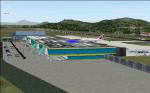
| Naples Capodichino LIRN 2006 v1.4 |
|
Images related to this file:
File Description:
This file contains the Napoli Capodichino LIRN 2006 v1.4 airport for FS2004. The scenery was created by Gianni Mantellini (Napulevola.it vice-CEO) using GMax, photorealistic/hand-made texture and full custom programming techniques. Very frame-rate friendly. For any kind of support please write a mail to [email protected] or post a question on forum.napulevola.it. Powered by www.napulevola.it. Enjoy!
| Filename: | Naples_Capodichino_LIRN_2006_v14.zip |
| License: | Freeware |
| Added: | 9th December 2011, 14:18:49 |
| Downloads: | 4,472 |
| Author: | Gianni Mantellini - Napulevola |
| Size: | 8.71 MB |
| Category: Flight Simulator 2004 - Scenery | |
| Bangor International Airport Maine V3 |
|
File Description:
An accurate and detailed scenery featuring modern buildings mixed with the historical remains of the old Dow air base. This version updates the cetral tower area and makes other improvements. Includes AFCAD2 for AI and alternative static aircraft. Also included is Rok Dolenec's KC-135E repainted in "Maineiac" colours for use as an AI or flyable aircraft.
| Filename: | Bangor_International_Airport_Maine_V3.zip |
| License: | Freeware |
| Added: | 5th March 2006, 02:17:08 |
| Downloads: | 9,518 |
| Author: | John Young |
| Size: | 3.93 MB |
| Category: Flight Simulator 2004 - Scenery | |
| Karipur VOCL |
|
Images related to this file:
File Description:
Karipur-VOCL for FS2004.
This contains the Airport of Calicut, Kerala, India
Karipur is a new International airport in Kozhikode or Calicut.
It handles planes to Middle East and Domestic.
This file contains the real airport.
Requeres South India Mesh and EZ library for small objects
to show up.
Terminal made in gmax and small objects added with EZ.
| Filename: | Karipur_VOCL.zip |
| License: | Freeware, limited distribution |
| Added: | 1st October 2010, 17:44:35 |
| Downloads: | 1,162 |
| Author: | Anstin Antony |
| Size: | 2.21 MB |
| Category: Flight Simulator 2004 - Scenery | |
| Boundary Bay CZBB - Traffic |
|
Images related to this file:
File Description:
This traffic file is for Boundary Bay, and has five planes making touch and goes at this airfield with its five training companies. The planes are FS standard Cessna 172 (2 of them) and Cessna 182 and Piper Cherokee, and a Piper Super Cub which can be downloaded from Avsim. For the Cub look for the pa18_v3 zip by J. E. Narcijo and install it; I presume you know how to do that.
There are new scenery bgl's as I have added more parking spots for AI. The pic shows a Cessna 150, but that you won't be able to download as it is a custom texture of the plane that I learnt to fly on at Rockcliffe Flying Club in Ottawa. You should already have installed my Boundary Bay post (boundary_bay.zip).
| Filename: | Boundary_Bay_CZBB__Traffic.zip |
| License: | Freeware, limited distribution |
| Added: | 13th May 2011, 15:14:44 |
| Downloads: | 554 |
| Author: | Roger Wensley |
| Size: | 950.48 KB |
| Category: Flight Simulator 2004 - Scenery | |
| Inuvik CYEV update in Northwest Territories, Canada |
|
Images related to this file:
File Description:
This is a revised version of Inuvik CYEV, with slightly improved building textures, some more add-ons around the buildings, new lighting for runway and apron, new signage, night textures for the terminal and tower, apron floodlights (by Sidney Schwartz) and landclass textures for the town. There is also new AI which gets rid of the porpoising First Air B737 and replaces it with a turboprop, and also links together Inuvik, Tuktoyaktuk, and Sachs Harbour; there is an Aklak Air DC3 flight (Kenn Borek under a diferent name) that leaves Inuvik at 1500GMT and does the round trip to Tuk, Sachs, Tuk, and then back to Inuvik. Aklavik, Sachs Harbour, and Tuktoyaktuk will be posted and should also be installed; there are linked scenery and AI improvements for all in the four posts.
| Filename: | Inuvik_CYEV_update_in_Northwest_Territories_Canada.zip |
| License: | Freeware, limited distribution |
| Added: | 14th May 2012, 17:18:26 |
| Downloads: | 614 |
| Author: | Roger Wensley |
| Size: | 6.62 MB |
| Category: Flight Simulator 2004 - Scenery | |
| Prudhoe Bay area on Alaska North Slope US |
|
Images related to this file:
File Description:
The Prudhoe Bay area of the Alaska north slope is dominated by all the equipment and machinery that is necessary for the extraction of oil and its transfer by the pipeline that reaches south to Valdez. Prudhoe Bay airport is now closed, and its replacement just to the south is Deadhorse PASC, with numerous storage, maintenance, and accomodation areas immediately to the north of the apron, and others adjacent to the road between the two. The runway is just under 6,500 feet with approach lights at both ends and ILS on 04 (true heading of 75 degrees). This scenery reflects the overall situation in 2011 and oil production facilities and buildings are included here. The airport buildings and those close to the airport are replicas of the real life buildings; while as distance increases the accuracy fades somewhat there are everywhere replica trucks and cross country vehicles that are true to life. Deadhorse handles around 7,000 passengers per month as staff are rotated in and out on Alaska Air and ERA flights and by oil company private flights. There are also freight flights to complement the trucking effort up the Dalton Highway. The Alaska Airlines terminal building and ERA (the red buildings nearby) are at one end of the apron, while at the other end is a very large and new green terminal, storage, hangar building built by the airport authority. All of the airport components, runways, taxiways, and aprons, are built up on a gravel base to raise them above the surrounding terrain that floods with melting snow, freezes, or dries out, according to the seasons. There are other new airstrips included here that serve the oil industry. Around 33 miles to the east is Badami PABP airport servicing a subsiduary oil producing area, with 5,000 feet of gravel runway. Some 28 miles to the west of Deadhorse is Ugnu-Kuparuk UBW with just over 6,000 feet of gravel (gravel in 2011, it is now asphalted) servicing oil production by Conoco Phillips, which uses 737's to fly staff in and out. A further 32 miles west is Alpine AK15 with 5,400 feet of gravel and also served by the Conoco Phillips 737's. To the south of Alpine and connected by road is the village of Nuiqsut. To the north of Alpine and reachable only by air in the delta of the Sagavanirktok River is CD-3, an oil collection and pump station area with another gravel runway of 3,000 feet. Other airstrips that were prviously posted are now updated, Nuiqsut and Oliktok. I experimented, but decided against trying to reproduce the several hundred miles of pipelines. The are new AI aircraft, and there are notes regarding downloading. There is a new "cement" texture (not its name, but used as that by SBuilder) for the built up gravel bases. It is slightly darker than the original but not so much that any previous use will be spoilt. You may wish to download my "Alaska Frozen Rivers and Lakes" which freezes lakes and the northern sea and makes them landable on wheels.
| Filename: | Prudhoe_Bay_area_on_Alaska_North_Slope_US.zip |
| License: | Freeware, limited distribution |
| Added: | 19th December 2017, 00:38:06 |
| Downloads: | 583 |
| Author: | Roger Wensley |
| Size: | 28.54 MB |
| Category: Flight Simulator 2004 - Scenery | |
| Legnano scenery - Italy |
|
Images related to this file:
File Description:
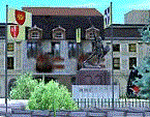
Homage to my town, scenery built mainly with existing objects, buildings by sintax and few experiments by GMax. It DOES NOT include any airport, but represents some pictures of Legnano town
Informations: Legnano is a town in north of Italy (approx 25 kmt NW Milan, ref coordinates N45 35.98 E8 54.59), reachable from Casorezzo ultralight airport (closest one) or all the near others of Milan area.
Here was done in 1176 the historical fight of the Alliance Lombarda's city-states against Federico Barbarossa German imperator. Legnano is also well known for his metallurgical and textile industries story.
Contents: rev.1 : down town square with municipal Palazzo Malinverni and S. Magno basilica, skyscraper, one of Olona river's bridges, G. Mari football stadium, Alberto da Giussano circus with related monument, encircled by the eight quarter's flags, F. Tosi and Manifattura industrial buildings, Rail station, external parking and glass building
rev.2 : Courthouse building with Teresa's face bronze statue and some more buidings, Palio hystorical figurants inside the stadium, Carroccio and Alberto da Giussano rider, Small goods train on railroad; S. Magno belltower reviewed, red sky-lights on top of skyscraper and chimney, Chimney smoke
| Filename: | Legnano_scenery__Italy.zip |
| License: | Freeware |
| Added: | 27th March 2011, 02:55:40 |
| Downloads: | 648 |
| Author: | Aldo Della Vedova |
| Size: | 6.83 MB |
| Category: Flight Simulator 2004 - Scenery | |
| North Haledon Lite |
|
File Description:
This is Chopper Friendly scenery, folks. It wasn't designed to be flown over at 10,000 feet - although, if you like to fly heavy iron into the major New York/New Jersey airports, you'll notice that it replaces the terrain elevation of Northern New Jersey with all the hills and valleys that the default scenery left out. No, this is interactive scenery. Built to be explored low and slow.
Want to perfect your landing skills in a huge playground of rooftops, irregular terrain, and tight spaces? This is the place. You won't find any unlandable surfaces or false crashes here - just hundreds of places to touch down ranging from beginner, through expert, to downright sick!
This is the lite version, designed for people who are having trouble with the frame rates of the full version. I've thinned out the houses and trees, and removed the buildings South of Oldham Pond - but managed to keep most of the interesting places to land. In the tests I've done, there was about a 20 percent frame rate increase on average compared to the full version, with nearly a 45 percent increase in the most framerate-hostile areas.
| Filename: | North_Haledon_Lite.zip |
| License: | Freeware, limited distribution |
| Added: | 1st June 2006, 04:48:01 |
| Downloads: | 656 |
| Author: | Mick Posch |
| Size: | 11.38 MB |
| Category: Flight Simulator 2004 - Scenery | |
| Kenmore Village Field CF08 near Ottawa in Ontario, Canada |
|
Images related to this file:
File Description:
Kenmore Village Field is in Ontario, at the northwest corner of the village of Kenmore. Kenmore is around 13 miles southeast of Ottawa airport and 3 miles east of Bank Farm Field. The village doesn't appear in FS as it is too small, but I have recreated it based on the roads that show in Ultimate Terrain. There is a grass runway 09/27 (actually 086/266) that is 3,100 feet long, and the grass is good, and with lights. The field is owned by a gentleman in his mid 70's who sold his plane five years ago and less than two years later discovered that he really didn't want to give up flying; he then went out and bought another slightly older and cheaper version of the one he sold. The house is in a direct line with the runway approach from the east; try to miss it. There is a large hangar and workshop behind the house and to the north of the runway center line, and a second older hangar on the same side a bit further along, both modeled specifically for this.
| Filename: | Kenmore_Village_Field_CF08_near_Ottawa_in_Ontario_.zip |
| License: | Freeware, limited distribution |
| Added: | 9th February 2010, 13:39:57 |
| Downloads: | 394 |
| Author: | Roger Wensley |
| Size: | 10.69 MB |
© 2001-2026 AVSIM Online
All Rights Reserved
Privacy Policy |