
Where Flight Simulation Enthusiasts Gather from Around the World!
AVSIM Library - Search Results

| Category: Flight Simulator 2004 - Scenery | |
| Wilgrove Airpark (8A6) |

|
Images related to this file:
File Description:
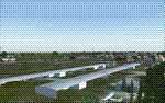
Wilgrove Airpark (8A6) is a small GA airport located just east of Charlotte, NC. It is often forgotten by pilots in Flightsimulator, yet it is a very busy place in the real-world, due to it's huge popularity with student and weekend GA pilots. There has never been a really good, accurate representation of this little gem created for the flightsim, so I decided to try my hand at it. This is my very first scenery project, and I hope you enjoy it. It was designed with ADE9X, and it requires RWY12 and EZ-Scenery objects extensively,(not included) so you will need to download these freeware scenery libraries prior to installation of this package for the Wilgrove Airpark scenery to display properly. - Glenn Mullis
| Filename: | Wilgrove_Airpark_8A6.zip |
| License: | Freeware, limited distribution |
| Added: | 22nd September 2010, 16:59:32 |
| Downloads: | 278 |
| Author: | Glenn Mullis |
| Size: | 4.4 MB |
| Category: Flight Simulator 2004 - Scenery | |
| Marshall Islands |
|
File Description:
Basic scenery and AFCAD files to create 21 new airstrips in the Republic of the Marshall Islands, and to add facilities to 12 of the default FS9 Marshall Island airports. Also 2 sets of AI flightplans for Air Marshall Islands.
New airstrips: AIC Airuk/Airok, AIM Ailuk, AUL Aur, BII Eneu (Bikini Atoll), EBN Ebadon, EAL Elenak, EBO Ebon, EJT Enajet/Enijet/Enejit, JAT Jabwot/Jabot, JEJ Jeh, KBT Kaben/Kapen, LIK Likiep, LML Lae, LOF Loen, MJE Majkin, NMU Namu, RNP Rongelap, TBV Tabal, UJE Ujae, WJA Woja, WTO Wotho.
Afcads for FS9 airports: 1Q9 Mili, N55 Jaluit, PKMA Enewetak, PKRO Dyess/Roi-Namur, Q30 Mejit, N36 Wotje, 3N1 Taora/Maloelap, N18 Tinak, N20 Ine, Q51 Kili, 3N0 Namorik/Namdrik, 03N Utirik.
| Filename: | Marshall_Islands.zip |
| License: | Freeware |
| Added: | 12th September 2005, 12:18:51 |
| Downloads: | 2,849 |
| Author: | Adrian Wright |
| Size: | 438.48 KB |
| Category: Flight Simulator 2004 - Scenery | |
| Santa Monica (SMO) High Resolution Airport Area Ground Scenery |
|
File Description:
This package contains high resolution ground scenery for the traffic pattern area of Santa Monica (SMO). Normal flight simulator scenery has a resolution of approximately 4.7 meters/pixel. That's OK at higher altitudes but leads to very blurry ground textures when flying low - e.g. in the traffic pattern. My high resolution airport area sceneries have a resolution 1.2 meters/pixel. This results in much more detail and a more realistic experience of "being there".
This scenery gives best results when combined with my "Southern-" and "Northern Los Angeles" standard resolution ground sceneries, available here:
Southern Los Angeles: http://library.avsim.net/esearch.php?CatID=fs2004scen&DLID=89921
Northern Los Angeles: http://library.avsim.net/esearch.php?CatID=fs2004scen&DLID=89911
For more information please visit: http://n330dg.batcave.net
| Filename: | Santa_Monica_SMO_High_Resolution_Airport_Area_Ground_Scenery.zip |
| License: | Freeware, limited distribution |
| Added: | 23rd August 2006, 22:08:43 |
| Downloads: | 7,973 |
| Author: | Gottfried Razek |
| Size: | 17.96 MB |
| Category: Flight Simulator 2004 - Scenery | |
| Aeropuerto Central Ciudad Real. LEDQ |
|
File Description:
This airport is not working yet. Central Ciudad Real Airport (previously known as Don Quijote Airport and South Madrid Airport) is an airport currently under construction in South Ciudad Real (Spain). The airport is waiting for AENA grant the necessary permissions to operate. The Central Ciudad Real airport (IATA code: CQM, ICAO code: LEDQ) is un private airport located in Ciudad Real province, between Ciudad Real and Puertollano. Is the first private international airport of Spain and it has a surface of 1234,45 hectare. The AFCAD file is property of the autor: Jesus Ramirez de ARellano Carmona. [email protected]. With his authorization for to use his file i made modifications adding objects to scenery with the program rwy12 object placer.
| Filename: | Aeropuerto_Central_Ciudad_Real_LEDQ.zip |
| License: | Freeware |
| Added: | 14th November 2008, 14:44:33 |
| Downloads: | 897 |
| Author: | Jose Ramos Ruiz |
| Size: | 466.91 KB |
| Category: Flight Simulator 2004 - Scenery | |
| 1963 La Paz Bolivia El Alto Airport Scenery |
|
File Description:
El Alto International Airport (IATA: LPB, ICAO: SLLP) is an international airport located in El Alto, near the city of La Paz, Bolivia; it serves national and international air traffic. At an altitude of 13,325 ft (4,061 m), it is one of the highest international airports in the world. The facility served as a focus city for the former Lloyd Aereo Boliviano, Bolivia's national air carrier, and is a hub for Aerosur, the country's only significant private airline. This scenery takes El Alto back to circa 1963, and with AI traffic from www.calclassic.com will be populated with everything from C-46 meat haulers to C-124 Globemasters. GMAX terminal by Jaap de Baare, local landclass by Tom Gibson, and almost everything else by Harry Biard.
| Filename: | 1963_La_Paz_Bolivia_El_Alto_Airport_Scenery.zip |
| License: | Freeware, limited distribution |
| Added: | 2nd May 2008, 02:26:42 |
| Downloads: | 3,913 |
| Author: | Harry Biard, Jaap de Baare, and Tom Gibson |
| Size: | 270.99 KB |
| Category: Flight Simulator 2004 - Scenery | |
| Asia Pacific 1962 Scenery |
|
Images related to this file:
File Description:

This scenery package contains the major airports for the Pacific Islands, China, and the Asian portion of the Pacific Rim as they were circa 1962, based upon material and photographs Mike has gathered. Major airports have been detailed with custom GMAX objects, and many other smaller airports/strips have been backdated by providing parking spots, correcting runway lengths, and removing the irritating strobes, taxi lines, and other features that did not normally exist during the 1950s and early 1960s. Cities/countries/islands covered include Fiji, Polynesia, Guam, Midway, Taipei, Korea, Philippines, New Guinea, China, and North Korea, among many others. Much of the rest of Asia has been already been covered by the Indochina 1962 scenery package, and is required for this package as well.
| Filename: | Asia_Pacific_1962_Scenery.zip |
| License: | Freeware, limited distribution |
| Added: | 23rd January 2012, 20:15:44 |
| Downloads: | 4,856 |
| Author: | Mike Stevens, Wolfgang Gersch, Tom Gibson |
| Size: | 12.24 MB |
| Category: Flight Simulator 2004 - Scenery | |
| FS9 Allakaket 6A8 in Alaska |
|
Images related to this file:
File Description:
Allakaket is on the Koyukuk River in Alaska, 40 miles southwest of Bettles. The population is just over 100, with a school that was opened in 1957 for both Allakaket and the nearby Alatna on the other side of the river. There was a very serious flood in 1964 with almost all of the village being underwater, and this resulted in the establishment of an additional housing area further inland and explains the thinly scattered housing in the original village site. The airfield was established in 1978 and has a gravel runway aligned 5-23 (or 05-23 if you are not American) that is just over 4,500 feet in length. Both the runway and the taxiway are marked with lit cones. The village airfield is served by Wright Air and Warbelows Air, both of them being based in Fairbanks and included in the revised AI for PANN that is included here. There are occasional other larger freight flights as required as there is no road access to the village and the river is too shallow to allow large freight barges; hence the runway length.
A note here about my scenery making. There will not be many more to follow this as I am almost at the end of the photos I either took or found for scenery purposes, plus I expect to move on from FS9 at some point during next year.
| Filename: | FS9_Allakaket_6A8_in_Alaska.zip |
| License: | Freeware, limited distribution |
| Added: | 23rd November 2019, 20:29:35 |
| Downloads: | 122 |
| Author: | Roger Wensley |
| Size: | 3.78 MB |
| Category: Flight Simulator 2004 - Scenery | |
| Waterfalls - Québec Short Hops |
|
File Description:
These files contain a few animated waterfalls effects spread over the Province of Québec. Most are near one of my sceneries. Others, I picked out while flying VFR. Also included are a couple of terrain fixes.
| Filename: | Waterfalls__Qubec_Short_Hops.zip |
| License: | Freeware |
| Added: | 11th June 2004, 00:00:52 |
| Downloads: | 1,992 |
| Author: | Leon Louis |
| Size: | 88.75 KB |
| Category: Flight Simulator 2004 - Scenery | |
| Trelew Naval Air Station - Argentina |
|
Images related to this file:
File Description:
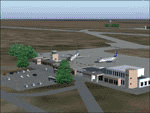
The Almirante Zar NAS is the operational base of the 6th Naval Air Square of the
Argentine Navy. The scenery includes the representation of both commercial and military platforms, as well as all their complementary buildings.
| Filename: | Trelew_Naval_Air_Station__Argentina.zip |
| License: | Freeware |
| Added: | 12th February 2010, 11:04:39 |
| Downloads: | 1,387 |
| Author: | Ramon Sola |
| Size: | 2.14 MB |
| Category: Flight Simulator 2004 - Scenery | |
| Bobzin, Germany |
|
File Description:
FS2004/AROE/Flight One Ultimate Terrain Europe Scenery-update of a small airfield near Hagenow/Mecklenburg/Germany in the former GDR. It used to be an airfield of the Agriculture Division of the East German Interflug.
| Filename: | Bobzin_Germany.zip |
| License: | Freeware |
| Added: | 18th April 2006, 22:15:53 |
| Downloads: | 1,958 |
| Author: | Uwe Schweitzer |
| Size: | 924.64 KB |
© 2001-2026 AVSIM Online
All Rights Reserved
Privacy Policy |