
Where Flight Simulation Enthusiasts Gather from Around the World!
AVSIM Library - Search Results

| Category: Flight Simulator 2004 - Scenery | |
| EDCP Peenemunde Military Airfield, Germany |

|
Images related to this file:
File Description:
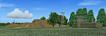
Peenemünde Airfield, Germany. The airfield Peenemunede is the one field of a row of military airfield sceneries of the former NVA. In the scenery are included the airfield and the technical supplies. The airfield was put into operation in 1961 in duty of the NVA. He accommodated the 9th fighter wing with Mig-21 and MiG-23. It is located along the Baltic Sea north of Peenemünde, Germany.
| Filename: | EDCP_Peenemunde_Military_Airfield_Germany.zip |
| License: | Freeware |
| Added: | 8th August 2011, 16:45:21 |
| Downloads: | 1,016 |
| Author: | Volker Loew, Rolf-Uwe Hochmuth, Frithjof Koch |
| Size: | 6.43 MB |
| Category: Flight Simulator 2004 - Scenery | |
| CYQU - Grande Prairie, Alberta, Canada |
|
Images related to this file:
File Description:
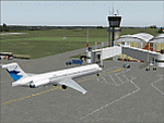
Grande Prairie is at 2,195 feet asl, 65 miles southeast of Dawsons Creek, 90 miles southwest of Peace River and around 60 miles east of the Rockies. The town has a population of 55,000 and growing. The airport is just to the west of the town and was originally a military base, built during WW2. The two runways are 07-25 and 11-29 and when one is the active runway then the other is used as a taxiway. AI in FS9 doesn't like this, and just stops at the first hold short without ever reaching the active runway. I have found a way to overcome this and AI will now use taxiway A and whichever runway is inactive to feed to and from both ends of the active runway. The vertical red tanks are for de-icing fluid; de-icing is carried out before take-off in the winter. The industrial area to the southeast is now larger than I have made it, but I kept it to this minimum size to keep frame rates down. All the buildings are modeled specifically for CYQU. The AI includes Westjet, Air Canada Jazz, and others as listed. The GA AI uses only FS9 standard aircraft.
| Filename: | CYQU__Grande_Prairie_Alberta_Canada.zip |
| License: | Freeware, limited distribution |
| Added: | 9th May 2014, 10:05:40 |
| Downloads: | 670 |
| Author: | Roger Wensley |
| Size: | 18.33 MB |
| Category: Flight Simulator 2004 - Scenery | |
| LFBT Tarbes/Lourdes-Pyrenees, France |
|
Images related to this file:
File Description:
Googly scenery for LFBT Tarbes - a normally quiet airport that just sees a few
domestic flights a day but bursts into life for those of the the Catholic faith to
participate in the pilgrimage to Lourdes. At these times it is served by a
regular stream of charter flights and the airport can handle aircraft as large
as the Boeing 747. The only scheduled flights are between here and Paris, normally operated by Canadair CRJ700 craft worked by Brittany Air International on behalf of Air France, but a huge range of charter operators - mostly from Italy, Ireland, Belgium, the
United Kingdom and Germany - may be seen here at times and although seasonal this
traffic represents 80% of the airport's entire annual activity.
The scenery does not purport to be ultra-accurate. Based on less-than-perfect
satellite imagery from Google Earth, the layout is proportionally correct but the
added airport features, such as buildings, are built from default Microsoft objects
and add-on libraries so will not look exactly like the real thing. You are not obliged to download and install any additional scenery libraries, but to enjoy this scenery in its entirety, you may wish to. It will work fine, with or without.
[File re-uploaded at the request of AVSIM]
| Filename: | LFBT_TarbesLourdesPyrenees_France.zip |
| License: | Freeware |
| Added: | 4th May 2010, 15:02:30 |
| Downloads: | 7,811 |
| Author: | John Hinson |
| Size: | 73 KB |
| Category: Flight Simulator 2004 - Scenery | |
| Fort Good Hope CZGH - Northwest Territories, Canada |
|
Images related to this file:
File Description:
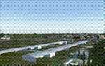
This is the second in a series of airfields that follow that early access route to the Canadian northern shore, the Mackenzie River. At the far northern end of the river there are Tuktoyaktuk, Inuvik, and Fort McPherson, all posted. Fort Good Hope is at 268 feet ASL and on the east bank of the Mackenzie, 180 miles southeast of Fort McPherson and 100 miles west of Great Bear Lake. The town has a population of around 560, and the main sources of income are from the traditional trapping and hunting. The airport is a mile south of the town, and has almost 4,000 feet of gravel runway. There are scheduled flights to the town by North Wright; I also have two AI GA flights and a Buffalo Airways delivery trip that hops north and south from field to field.
| Filename: | Fort_Good_Hope_CZGH__Northwest_Territories_Canada.zip |
| License: | Freeware, limited distribution |
| Added: | 4th July 2014, 21:03:03 |
| Downloads: | 276 |
| Author: | Roger Wensley |
| Size: | 3.08 MB |
| Category: Flight Simulator 2004 - Scenery | |
| Ontario Small Fields in Canada: #6 Nixon CNX8 |
|
Images related to this file:
File Description:
This is the sixth in a series of small airfields in southern Ontario Canada, Nixon CNX8, an airfield 20 miles south of Brantford and 10 miles north of Lake Erie, just west of the small town of Simcoe. It was not included in FS9 as it did not exist then; I do not know when it was first registered, but it was prior to April 2010 (the date of the oldest copy of the Canada Flight Supplement that I have with me). The airfield has a grass runway of 2,800 feet aligned 12/30, unlit. The owner has a small crop-spraying business, and there are also hangars rented to local plane owners. Fuel and oil is available.
This scenery post is not necessarily complete in itself and presumes you are adding it to the series of Ontario Small Fields.
| Filename: | Ontario_Small_Fields_in_Canada_6_Nixon_CNX8.zip |
| License: | Freeware, limited distribution |
| Added: | 27th October 2015, 12:11:48 |
| Downloads: | 145 |
| Author: | Roger Wensley |
| Size: | 5.41 MB |
| Category: Flight Simulator 2004 - Scenery | |
| Fuerstenfeld (LOGF), Austria |
|
File Description:
Fuerstenfeld (LOGF) is a small airfield east of Graz, Austria. This scenery consists of custom made objects and is only an adapted version of my FS2002-scenery. This scenery is compatible with "Austria Professional FS2004".
| Filename: | Fuerstenfeld_LOGF_Austria.zip |
| License: | Freeware |
| Added: | 27th February 2006, 14:26:42 |
| Downloads: | 2,587 |
| Author: | Harald Kraft |
| Size: | 2.55 MB |
| Category: Flight Simulator 2004 - Scenery | |
| SKPE Matecana International Airport |
|
File Description:
Matecana International Airport (Spanish: Aeropuerto Internacional de Matecana) (IATA: PEI, ICAO: SKPE) is an airport located in the city of Pereira, Colombia. It connects the Risaralda department of Colombia. It also serves the cities of Armenia, Cartago, and Manizales in emergency situations.
This file has the right coordenates and characteristics of the airport.
| Filename: | SKPE_Matecana_International_Airport.zip |
| License: | Freeware |
| Added: | 22nd October 2011, 23:58:03 |
| Downloads: | 726 |
| Author: | Anwar Gonzalez |
| Size: | 8.58 KB |
| Category: Flight Simulator 2004 - Scenery | |
| OASG - Sheberghan Airfield - Jowzjan, Afghanistan |
|
File Description:
Sheberghan Airfield (ICAO: OASG) is located in the Jowzjan Province in the northwest part of Afghanistan. The airfield is located in a plain adjacent to a river, 17 nautical miles (31 km) northeast of Sheberghan, 12 nautical miles (22 km) west of Aqchah, and 40 nautical miles (74 km) east of Andkhoy.
| Filename: | OASG__Sheberghan_Airfield__Jowzjan_Afghanistan.zip |
| License: | Freeware |
| Added: | 11th November 2014, 18:02:50 |
| Downloads: | 273 |
| Author: | Billy Guo |
| Size: | 222.96 KB |
| Category: Flight Simulator 2004 - Scenery | |
| EGMD - Lydd Airport - Lydd, England ** UPDATED VERSION ** |
|
File Description:
Lydd Airport (IATA: LYX, ICAO: EGMD) is located 1.2 NM (2.2 km; 1.4 mi) northeast of the town of Lydd and 12 NM (22 km; 14 mi) south of Ashford in the District of Shepway within Kent, England. It is also known as London Ashford Airport, which officially only refers to its operator.
| Filename: | EGMD__Lydd_Airport__Lydd_England___UPDATED_VERSION.zip |
| License: | Freeware |
| Added: | 16th December 2014, 17:38:41 |
| Downloads: | 463 |
| Author: | Billy Guo |
| Size: | 397.57 KB |
| Category: Flight Simulator 2004 - Scenery | |
| Wilgrove Airpark (8A6) |
|
Images related to this file:
File Description:
Wilgrove Airpark (8A6) is a small GA airport located just east of Charlotte, NC. It is often forgotten by pilots in Flightsimulator, yet it is a very busy place in the real-world, due to it's huge popularity with student and weekend GA pilots. There has never been a really good, accurate representation of this little gem created for the flightsim, so I decided to try my hand at it. This is my very first scenery project, and I hope you enjoy it. It was designed with ADE9X, and it requires RWY12 and EZ-Scenery objects extensively,(not included) so you will need to download these freeware scenery libraries prior to installation of this package for the Wilgrove Airpark scenery to display properly. - Glenn Mullis
| Filename: | Wilgrove_Airpark_8A6.zip |
| License: | Freeware, limited distribution |
| Added: | 22nd September 2010, 16:59:32 |
| Downloads: | 278 |
| Author: | Glenn Mullis |
| Size: | 4.4 MB |
© 2001-2026 AVSIM Online
All Rights Reserved
Privacy Policy |