
Where Flight Simulation Enthusiasts Gather from Around the World!
AVSIM Library - Search Results

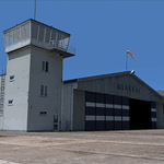
| Category: Flight Simulator 2004 - Scenery | |
| Saglek CYSV in northern Labrador, Newfoundland Canada |

|
Images related to this file:
File Description:
Kangiqsualujjuaq is in northern Quebec on the east side of Ungava Bay, and the rocky coastline stretches north from there for 130 miles before turning sharply to head south as the Atlantic shore of Labrador. On this shore and 120 miles almost due east of Kangiqsualujjuaq is Saglek, once a US radar base as part of the DEW line, and then a Canadian base with a Long Range Radar sited 1,200 feet above the airstrip on the top of the vertical cliff. The airstrip is still in use today as an access to the Torngat Mountains Canadian National Park area further north, with organised summer camps and walks etc and helicopter relays from airstrip to campsites. Saglek closes the gap between my post of Kangiqsualujjuaq and the string of airfields further south on the Labrador coast, such as Nain, Davis Inlet, Hopedale, Makkovik, and Postville etc. These have all been made by Flight Ontario and posted along with the Goose Bay Air Base, which also functions as a civil airport.
| Filename: | Saglek_CYSV_in_northern_Labrador_Newfoundland_Cana.zip |
| License: | Freeware, limited distribution |
| Added: | 17th August 2017, 17:11:29 |
| Downloads: | 162 |
| Author: | Roger Wensley |
| Size: | 3.86 MB |
| Category: Flight Simulator 2004 - Scenery | |
| Minstrel Island CAX7 float base in British Columbia, Canada |
|
Images related to this file:
File Description:
This is the third in a series of new and renovated float bases in BC. Minstrel Island is on the south side of Knight Inlet and 25 miles west of Knight Inlet Lodge (the previous post in this series). There is a resort on the island, though it is hidden from the air by the trees. Fuel and oil are both available at the dock, and there is a 17 feet tidal range, which would be interesting of it could be replicated in FS. The AI is an adaptation of that for CF36 and involves a GA Cessna, and a Seair Beaver flying from Campbell River to Knight Inlet Lodge via Minstrel Island. Again, because of large hills the landing of the AI may or may not take place, depending on wind direction and whether or not they fly into solid rock before landing. Take off and departure will take place. Ultimate Terrain Alaska/Canada would be a definite plus to get the water in the right shape and place. This scenery will not work without it.
| Filename: | Minstrel_Island_CAX7_float_base_in_British_Columbi.zip |
| License: | Freeware, limited distribution |
| Added: | 3rd January 2017, 15:38:57 |
| Downloads: | 224 |
| Author: | Roger Wensley |
| Size: | 3.54 MB |
| Category: Flight Simulator 2004 - Scenery | |
| EPGO Goraszka 2010 - The Airshow Challenge |
|
Images related to this file:
File Description:
EPGO Goraszka 2010 - The Airshow Challenge is a freeware, extremely detailed scenery of a general aviation airport located 12nm (20km) south-east of Warsaw downtown and Warsaw Frederic Chopin International Airport, Poland. EPGO Goraszka airfield was built in 1994 and currently belongs to a General Aviation company, which offers aero-taxi flights, air transport and special flights (air photo, patrol) and airport services. The airport has a 800m-long runway and a lightened helipad, which can be used by helicopters of up to 5700kg weight. General Aviation's fleet includes Antonov AN-2, PZL-104 Wilga 80, Bell 407 and 427. Since 1996 the International Air Picnic Goraszka is organized every year by the "Polish Eagles" foundation created on initiative of Zbigniew Niemczycki.
The scenery is equipped with an automatic installer. Currently we support a safe, manual way of adding new sceneries to the Scenery Library in Flight Simulator. This is just one thing users need to do for themselves. Detailed instructions will be given during the installation process.
Scenery features:
-Compatible with FS2004 only
-Highest level of accuracy in geographic positioning, modeling and texturing
-Incredibly high quality photoreal textures of all airport buildings. Textures are based on over 300 real world -photographs made for this project.
-Hundreds of 3D objects like tents, exhibitions, airport buildings and surrounding buildings
-Life in the airport: people and cars will enhance your feelings
-AI traffic, animations and effects, designed specifically for FS2004
-Some buildings include interior (control tower)
-High quality aerial photos of the airport surroundings (5 seasons + night) with autogen and water mask
-Ultra high quality aerial photos of the airport (with seasons)
-Plain airport scenery with no airshow objects available too (details in the manual)
-Product includes manual and airport charts in PDF format
EPGO Goraszka 2010 - The Airshow Challenge scenery is compatible with almost every payware add-on, including Ultimate Terrain Eastern Europe and Warsaw Photo Scenery by Simdesign.
Scenery by Drzewiecki Design - www.drzewiecki-design.net
| Filename: | EPGO_Goraszka_2010__The_Airshow_Challenge.zip |
| License: | Freeware |
| Added: | 14th July 2010, 09:49:07 |
| Downloads: | 3,752 |
| Author: | Drzewiecki Design - Stanislaw Drzewiecki, Jakub Paczek |
| Size: | 132.03 MB |
| Category: Flight Simulator 2004 - Scenery | |
| Maurice Bishop TGPY on Grenada in the Caribbean |
|
Images related to this file:
File Description:
Grenada island is 17 miles south of the southernmost island of the Grenadines, Carriacou; there are some smaller islands between the two. Grenada is 18 miles long and around 8 miles wide, has an estimated population of 110,000, and produces a very large part of the world's annual nutmeg harvest. The capital, St Georges, is by far the largest town and is at the southern end of the island, with the airport close by.
The airport is now called Maurice Bishop, but for some years was called Point Salines. The runway is just over 9,000 feet long and oriented 10/28. Point Salines replaced Pearl Airport, which is on the east coast 12 miles northeast of St Georges and was difficult to expand as the runway had mountains at one end and the sea at the other. Pearl is now closed; it is included here but only as a visual landmark with "closed" markings. There are regular international flights from North America and Europe, some of which are seasonal only (Air Canada for instance) and local connecting flights by LIAT and SVG. I retained the default control tower as it is some distance away. In real life it is also some distance away and on a hill northwest of the terminal. Which is why I did not take photos from which I would have made the real one. The hill does not feature in FS9.
| Filename: | Maurice_Bishop_TGPY_on_Grenada_in_the_Caribbean.zip |
| License: | Freeware, limited distribution |
| Added: | 11th June 2013, 23:28:17 |
| Downloads: | 825 |
| Author: | Roger Wensley |
| Size: | 7.38 MB |
| Category: Flight Simulator 2004 - Scenery | |
| Monterey Academy CA66 California Scenery |
|
File Description:
This is a scenery upgrade for Monterey Academy Airstrip, California (CA66). This is part Seven of a
series of small airstrip and minor airfield scenery enhancements which are based on real world data
from Google Earth.
Changes to default include an AFCAD file that covers some of the buildings that seem to be
associated with the airstrip, Landclass change to reflect the fact that the strip lies in agricultural
ground rather that the scrubland the default has it in. Note that the buildings are used to appear
the same as they do from directly above rather than a genuine representation of what is probably
there. So from ground level it will look a lot different to the real thing should you be familiar with it!
This is due to the limited number of buildings available ATM.
Also My screenshots are using Flight1 Ground Environment textures, so your land may look different
if you have the default terrain.
Thanks to Jon "Scruffyduck" Masterson for tutorials on LC and scenery design.
Built using EZ_Scenery, Lee Swordy's AFCAD and SBuilder. You must have rwy12 and EZ scenery
libraries installed for the buildings to show, both libraries of objects are free
EZ Library is available from this URL http://www.abacuspub.com/pub/AbacusEZLibraries.exe
rwy12 from Avsim and additional EZ Custom libraries from Avsim also, search under Scenery design.
| Filename: | Monterey_Academy_CA66_California_Scenery.zip |
| License: | Freeware |
| Added: | 25th March 2006, 23:10:11 |
| Downloads: | 589 |
| Author: | Kim Gowney |
| Size: | 250.98 KB |
| Category: Flight Simulator 2004 - Scenery | |
| Alaska South Slope 11; Brevig Mission KTS |
|
Images related to this file:
File Description:
There are four main northwestern Alaska towns which are serviced by Alaska Airlines, and from which local flights spread out. The northernmost is Barrow. Southwest of Barrow is Kotzebue, then Nome, and the furthest south is Bethel (not yet made). This is the fourth in a series for local flights from Nome, and it is on the coast around 50 miles east of Wales, and 60 miles northwest of Nome. There are two other airfields around a large lagoon that is almost totally enclosed from the sea, and Brevig Mission is on the northern shore, just 12 miles northeast of the already-posted Port Clarence. Brevig Mission has a populaton that has risen to 390 in recent years. Tollef Brevik was a Lutheran missionary who was both a pastor and teacher for the Inuit in the area from 1894 onward, travelling from community to community but based in Teller, 6 miles southeast. the village now called Brevig Mission was founded at a later date (unknown to me) and took his name. The airstrip is just east of the village, with two gravel runways; 11-29 which is 3,600 feet of gravel and 04-22 which is 2,600 feet and with PAPI on 22. The AI is the usual for this area, Bering and ERA with some GA and cargo by Everts.
| Filename: | Alaska_South_Slope_11_Brevig_Mission_KTS.zip |
| License: | Freeware, limited distribution |
| Added: | 25th October 2016, 20:52:56 |
| Downloads: | 198 |
| Author: | Roger Wensley |
| Size: | 2.55 MB |
| Category: Flight Simulator 2004 - Scenery | |
| Port Blair Airport / India |
|
Images related to this file:
File Description:

I am a novice with Airport scenery design. I hope FS enthusiasts would appreciate my work.
Port Blair is the capital of the Andaman and Nicobar Islands, a union territory of India situated in the Bay of Bengal. It is an airport located 2 km (1.2 mi) south of Port Blair and is the main airport of the Andaman and Nicobar Islands.
| Filename: | Port_Blair_Airport__India.zip |
| License: | Freeware |
| Added: | 5th July 2019, 17:31:43 |
| Downloads: | 300 |
| Author: | Tushar Deshpande |
| Size: | 1008.78 KB |
| Category: Flight Simulator 2004 - Scenery | |
| Timberline Lodge V1.0 |
|
File Description:
Timberline Lodge-gmax version1.0 for FS2004. This scenery focuses on Timberline Lodge (National Historic Landmark) located on Mt. Hood, Oregon and includes a helipad with night lighting effects. On June 11, 1936, at the brutal height of the Great Depression, ground was broken for a project unique in America. Timberline Lodge was built entirely by hand, inside and out, by unemployed craftspeople hired by the Federal Works Projects Administration. The building is a tribute to their skills and a monument to a government which responded not only to the physical needs of its people in a desperate time, but also to the needs of their spirits. Additional scenery elements complied with FS Scenery Creator 1.5
| Filename: | Timberline_Lodge_V10.zip |
| License: | Freeware |
| Added: | 18th October 2003, 20:54:51 |
| Downloads: | 1,432 |
| Author: | M. Allen Richards |
| Size: | 1.07 MB |
| Category: Flight Simulator 2004 - Scenery | |
| The Calgary Tower |
|
File Description:
Accurate scale model of Calgary's world famous Calgary Tower. Highly detailed day and night textures with high resolution DXT bitmaps for maximum realism. The model features lights on the upper deck and railings on the roof. Flashing beacon on top of the Radio antenna. The Olympic Torch is included below the antenna. Flame does not turn on... yet. The low resolution version is included in Sydney Swartz's
Calgary City scenery package. The tower is located exacty at its real world coordinates and is exactly 625 Feet or 191 Meters high at the top of the spire as it is in the real world. I hope you all enjoy this model. This ones for you Calgary.
| Filename: | The_Calgary_Tower.zip |
| License: | Freeware, limited distribution |
| Added: | 31st January 2006, 04:47:47 |
| Downloads: | 2,062 |
| Author: | Rick Milne |
| Size: | 1.68 MB |
| Category: Flight Simulator 2004 - Scenery | |
| LOD10 (38-m) Glacier Bay National Park, Alaska |
|
File Description:
This LOD10 (38-m) add-on mesh of Glacier Bay National Park and the adjacent Lynn Canal area between Juneau and Skagway (N58-60 W134-138) is an optional (!) upgrade of gl_bay_1.zip (by Holger Sandmann and Jim Keir). It adds more detail to the mountainous areas and allows to locally override other installed Alaska add-on meshes without having to deactivate them. The USGS NED seamless digital elevation data used for this mesh have a 2-arcsec (~60-m) resolution. Thus, the compilation as LOD10 (38-m) will reveal all terrain details contained in the source data. Please read the gl_bay_1.zip read-me file for further information about the special features of the Glacier Bay Project.
| Filename: | LOD10_38m_Glacier_Bay_National_Park_Alaska.zip |
| License: | Freeware, limited distribution |
| Added: | 16th February 2004, 03:40:57 |
| Downloads: | 8,593 |
| Author: | Holger Sandmann |
| Size: | 24.98 MB |
© 2001-2026 AVSIM Online
All Rights Reserved
Privacy Policy |