
Where Flight Simulation Enthusiasts Gather from Around the World!
AVSIM Library - Search Results

| Category: Flight Simulator 2004 - Scenery | |
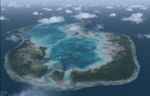
| Huahine Airport, French Polynesia, NTTH, Fare |

|
File Description:
This is an all new airport on the Island of Huahine in French Polynesia, just a short hop from Bora Bora. It is located in the Society Islands of French Polynesia which contain 98% of the areas population, with Tahiti being the main area of commerce, and urban center. This scenery includes the terminal, and a few rustic hangars and storage facilities. This Island like most in the area is supported by the tourist industry, and they are known for being the most beautiful and romantic Islands in the world. As with all of the airports in this area, this one will be greatly enhanced with the terrain mesh from Rolf Keibel and Johnathan Applegate, under the name FPSIMESH.zip. Afcad by Ray Smith is also included in this file.
| Filename: | Huahine_Airport_French_Polynesia_NTTH_Fare.zip |
| License: | Freeware |
| Added: | 7th May 2004, 12:44:33 |
| Downloads: | 11,738 |
| Author: | Bill Melichar |
| Size: | 2.72 MB |
| Category: Flight Simulator 2004 - Scenery | |
| Glacier Bay National Park, Alaska |
|
File Description:
Add-on meshes can greatly improve the detail of the FS terrain but often conflict with the inaccurate placement of the other default FS landscape elements, particularly in coastal and mountainous areas. This project showcases new methods and software that allow for semi-automated development of FS landscapes from accurate source data. The files completely replace the default FS landscape of Southeast Alaska's Glacier Bay National Park and the adjacent Lynn Canal area between Juneau and Skagway (N58-60 W134-138), including shorelines, islands, and lakes, as well as glaciers, landclass, man-made features, and a LOD9 (76-m) terrain mesh. Optional AI floatplane traffic at four seaplane bases is included. A LOD10 (38-m) mesh of the same area is available as a separate optional download. FS2002 users please use fs8glbay.zip instead.
| Filename: | Glacier_Bay_National_Park_Alaska.zip |
| License: | Freeware, limited distribution |
| Added: | 16th February 2004, 03:40:31 |
| Downloads: | 17,192 |
| Author: | Holger Sandmann, Jim Keir |
| Size: | 10.43 MB |
| Category: Flight Simulator 2004 - Scenery | |
| CYQR 2015 - Regina International Airport - Groome Field |
|
Images related to this file:
File Description:

Regina International Airport can trace its history back to 1919, when Regina airport became the first registered "air harbour" in Canada. This virtual model of CYQR represents the airport as it was in spring of 2015. CYQR airport is the gateway to southern Saskatchewan, Canada and is situated in Regina, which is the provincial capital. The airport is served by Air Canada, Air Canada Express, Westjet, Westjet Encore, West Wind Aviation, Express Air, Sunwing, Air Transat, Cargojet and Delta Airlines. The airport is named for Roland Groome, who was the first registered pilot in Canada.
This scenery was constructed with GMAX and includes detailed models of all buildings on the airport property. The scenery also includes the major landmark buildings of the City of Regina and those on the Runway approaches.
| Filename: | CYQR_2015__Regina_International_Airport__Groome_Fi.zip |
| License: | Freeware, limited distribution |
| Added: | 12th August 2015, 00:51:35 |
| Downloads: | 2,808 |
| Author: | Gregory Putz |
| Size: | 183.45 MB |
| Category: Flight Simulator 2004 - Scenery | |
| Doha International Airport (OTBD) - (AIRAC update May 2012) |
|
Images related to this file:
File Description:

This is a very simple rendition of Doha airport as of May 2012 with default and library objects. It updates my previous version of this scenery with recent changes implemented as of AIRAC1205:
- Runway designator changed to 15/33
- New aprons and parking stands
- Many other features and fixes
All taxiways, aprons, parkings are perfectly accurate according to airport charts and personal experience. Buildings and airport objects are placed according to real life but are not themselves a real depiction. I have used default objects as well as library objects found on the Internet. If anyone downloading this airport has knowledge on how to create custom buildings and objects to improve the scenery, please let me know, I'll be happy to share photos of the real thing for you.
| Filename: | Doha_International_Airport_OTBD__AIRAC_update_May_.zip |
| License: | Freeware, limited distribution |
| Added: | 12th May 2012, 23:09:38 |
| Downloads: | 5,280 |
| Author: | Frederic Revol |
| Size: | 6.79 MB |
| Category: Flight Simulator 2004 - Scenery | |
| French Polynesia Tuamotu Archipelago 2006 Part A |
|
Images related to this file:
File Description:
These files improve specific scenerys (Tuamotu Archipelago) of FS2004.
The archiperago scattered in the northeast of Tahiti island is composed of 78 islands.
I reproduced the 55 islands in the archipelago as add-on senery.
They are islands like a beautiful necklace sprinkled in the tropical ocean.
Tuamotu2006A includes the islands from Mataiva (the west edge of the archipelago)
to 144 West of the whole archipelago because of the file size.
When the "Tuamotu2006B" (fpta2k6b.zip) scenery is installed together with this Tuamotu2006A,
the huge Tuamotu Archipelago including all of "The Chain Islands" will appear.
| Filename: | French_Polynesia_Tuamotu_Archipelago_2006_Part_A.zip |
| License: | Freeware, limited distribution |
| Added: | 3rd December 2011, 23:53:28 |
| Downloads: | 8,533 |
| Author: | Kazuo Kawamura |
| Size: | 93.63 MB |
| Category: Flight Simulator 2004 - Scenery | |
| Coal Harbour CAQ3 float base in British Columbia, Canada |
|
Images related to this file:
File Description:
This is number eight in a series of new and renovated float bases in BC. Coal Harbour is in a sheltered cove off Holberg Inlet on the northwest coast of Vancouver Island, close to the village and 10 miles southwest of the Port Hardy float base. There is 100LL fuel and oil available. Due to the deep fjords that run into Vancouver Island from the west coast Coal Harbour is actually closer to the east coast than it is to the west coast. The tortuous route in through Quatsino Sound and Rupert Sound shelters the waters of Holberg Inlet from the stormy seas of the west coast, and fishing boats take advantage of this. The floatplane dock is to the south of the large (and old) hangar, adjacent to the southern end of the fixed dock where the ramp bridge descends to the floating docks. The video makes it clearer. The AI is a further adaptation of the CF36 AI and involves Beavers and Otters as listed in the AI folder. Due to the surrounding hills there may be some interference with AI aircraft, depending on the wind direction, though I have watched succesful Beaver and Otter landings. Amid the hills there is a very large hole in the ground to the east. The village name suggests it may have been for coal but though in fact there was a coal mine, that was a much smaller and unsuccesful venture; this particular scene of enthusiastic digging was for copper, until 1996. The main claim to fame of Coal Harbour was that it was the last whaling station in North America, using the buildings that were part of the RCAF float plane patrol base during WW2. One downloader reported a texture problem with Port McNeill, to which we found a solution. As he was the only person to email me I am going to presume that nobody else had the problem.
| Filename: | Coal_Harbour_CAQ3_float_base_in_British_Columbia_C.zip |
| License: | Freeware, limited distribution |
| Added: | 25th January 2017, 00:29:05 |
| Downloads: | 225 |
| Author: | Roger Wensley |
| Size: | 7.79 MB |
| Category: Flight Simulator 2004 - Scenery | |
| Peru and Bolivia Thermals |
|
File Description:
A set of thermals that include the complete Andean Territory of Bolivia and Peru
| Filename: | Peru_and_Bolivia_Thermals.zip |
| License: | Freeware |
| Added: | 30th August 2005, 13:15:55 |
| Downloads: | 742 |
| Author: | Alejandro Villa |
| Size: | 3.49 MB |
| Category: Flight Simulator 2004 - Scenery | |
| Monterey Academy CA66 California Scenery |
|
File Description:
This is a scenery upgrade for Monterey Academy Airstrip, California (CA66). This is part Seven of a
series of small airstrip and minor airfield scenery enhancements which are based on real world data
from Google Earth.
Changes to default include an AFCAD file that covers some of the buildings that seem to be
associated with the airstrip, Landclass change to reflect the fact that the strip lies in agricultural
ground rather that the scrubland the default has it in. Note that the buildings are used to appear
the same as they do from directly above rather than a genuine representation of what is probably
there. So from ground level it will look a lot different to the real thing should you be familiar with it!
This is due to the limited number of buildings available ATM.
Also My screenshots are using Flight1 Ground Environment textures, so your land may look different
if you have the default terrain.
Thanks to Jon "Scruffyduck" Masterson for tutorials on LC and scenery design.
Built using EZ_Scenery, Lee Swordy's AFCAD and SBuilder. You must have rwy12 and EZ scenery
libraries installed for the buildings to show, both libraries of objects are free
EZ Library is available from this URL http://www.abacuspub.com/pub/AbacusEZLibraries.exe
rwy12 from Avsim and additional EZ Custom libraries from Avsim also, search under Scenery design.
| Filename: | Monterey_Academy_CA66_California_Scenery.zip |
| License: | Freeware |
| Added: | 25th March 2006, 23:10:11 |
| Downloads: | 589 |
| Author: | Kim Gowney |
| Size: | 250.98 KB |
| Category: Flight Simulator 2004 - Scenery | |
| Alaska South Slope 11; Brevig Mission KTS |
|
Images related to this file:
File Description:
There are four main northwestern Alaska towns which are serviced by Alaska Airlines, and from which local flights spread out. The northernmost is Barrow. Southwest of Barrow is Kotzebue, then Nome, and the furthest south is Bethel (not yet made). This is the fourth in a series for local flights from Nome, and it is on the coast around 50 miles east of Wales, and 60 miles northwest of Nome. There are two other airfields around a large lagoon that is almost totally enclosed from the sea, and Brevig Mission is on the northern shore, just 12 miles northeast of the already-posted Port Clarence. Brevig Mission has a populaton that has risen to 390 in recent years. Tollef Brevik was a Lutheran missionary who was both a pastor and teacher for the Inuit in the area from 1894 onward, travelling from community to community but based in Teller, 6 miles southeast. the village now called Brevig Mission was founded at a later date (unknown to me) and took his name. The airstrip is just east of the village, with two gravel runways; 11-29 which is 3,600 feet of gravel and 04-22 which is 2,600 feet and with PAPI on 22. The AI is the usual for this area, Bering and ERA with some GA and cargo by Everts.
| Filename: | Alaska_South_Slope_11_Brevig_Mission_KTS.zip |
| License: | Freeware, limited distribution |
| Added: | 25th October 2016, 20:52:56 |
| Downloads: | 198 |
| Author: | Roger Wensley |
| Size: | 2.55 MB |
| Category: Flight Simulator 2004 - Scenery | |
| Maurice Bishop Intl (TGPY) |
|
Images related to this file:
File Description:

"Maurice Bishop" is the new name of Grenada island airport, the old was "Point Salines"
"TGPY_Maurice Bishop Intl" is the Scenery of the International Airport of Grenada Carribean Island.
| Filename: | Maurice_Bishop_Intl_TGPY.zip |
| License: | Freeware |
| Added: | 10th December 2013, 23:57:26 |
| Downloads: | 1,995 |
| Author: | Delblond Christian |
| Size: | 12.58 MB |
© 2001-2026 AVSIM Online
All Rights Reserved
Privacy Policy |