
Where Flight Simulation Enthusiasts Gather from Around the World!
AVSIM Library - Search Results

| Category: Flight Simulator 2004 - Scenery | |
| RN River Class Frigates /Destroyer Escorts |

|
Images related to this file:
File Description:
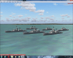
FS2004 Royal Navy River Class Frigates/Destroyer Escorts, for static use. Intended as stand alone or escort vessels for Carriers. All six vessels are provided, Derwent, Paramatta, Stuart, Yarra, Swan, and Torrens, depicting the vessels at various stages in their life.
A separate Rwy12 file is provided.
By Mike Hudson.
| Filename: | RN_River_Class_Frigates__Destroyer_Escorts.zip |
| License: | Freeware |
| Added: | 15th October 2015, 17:48:20 |
| Downloads: | 158 |
| Author: | Mike Hudson |
| Size: | 4.83 MB |
| Category: Flight Simulator 2004 - Scenery | |
| CYPE - Peace River - Northwest Alberta, Canada |
|
Images related to this file:
File Description:
The Peace River flows east from the Rockies, joining up with the Slave River to empty into Great Slave Lake. The town is on both banks close to a bend, 245 miles northwest of Edmonton. The population is 7,000 and the surrounding area is either farmland or forest and used for winter sports; Peace River hosted the 2004 Alberta Winter Games. The airport is just over 3 miles west of the town. The runway is 5,000 feet of wide asphalt (150 feet) aligned 04/22, lit, and with PAPI. There is a second runway to the south of the main runway, 1,900 feet of grass and aligned 08/26. The apron is to the north of the runway at the eastern end and is large; there is a purpose-built terminal building, plus other hangar buildings along taxiway C that extends westward from the apron. The airport gives the impression that it is under-used; there are no long lines of parked planes waiting for the weekend and few scheduled flights. These are mainly (totally?) by Sunwest Home Aviation, but unfortunately nobody has made the textures for Sunwest and my talents do not run in that direction so I have made believable substitutions. There is also a small but obstinate AI difficulty, described in the notes.
| Filename: | CYPE__Peace_River__Northwest_Alberta_Canada.zip |
| License: | Freeware, limited distribution |
| Added: | 10th November 2013, 23:56:22 |
| Downloads: | 332 |
| Author: | Roger Wensley |
| Size: | 10.83 MB |
| Category: Flight Simulator 2004 - Scenery | |
| Chelsea Dams on the Gatineau River |
|
Images related to this file:
File Description:
The Chelsea Dams are on the Gatineau River, just north of Rockcliffe airfield. I have used the plural as while there is only one dam as such, there is a second generating station just south of the dam; so "it" is more generally called "the Chelsea Dams". The dams mark the point where, if you are flying south down the Gatineau River towards Rockcliffe, you should be either below 1,500 feet or talking to the Ottawa control tower. While not a reporting point as noted in the supplement notes about flying vfr in the Ottawa area the dams are still the natural reporting point when approaching Rockcliffe and announcing landing intentions. Plus they are a visible landmark from way off, so here they are.
| Filename: | Chelsea_Dams_on_the_Gatineau_River.zip |
| License: | Freeware, limited distribution |
| Added: | 14th February 2010, 23:11:15 |
| Downloads: | 255 |
| Author: | Roger Wensley |
| Size: | 879.08 KB |
| Category: Flight Simulator 2004 - Scenery | |
| Bar River CPF2 in Ontario, Canada |
|
Images related to this file:
File Description:
Bar River is an airfield in Ontario, some 20 miles east of Sault Ste Marie. It is owned and operated by Springer Aerospace, an aircraft maintenance company. They specialise in turboprop aircraft and carry out work for several northern airlines plus private owners; they also have a paintshop and have painted planes for a number of airlines including Air Canada. There used to be two runways but one is now only a taxiway and the one remaining is aligned 36-18 and 4,415 feet long. Adjacent to this runway is "the ditch", a 2,000 feet long water runway; there is no way put of the ditch except by fork lift or by take off. In the winter a number of float planes are stored on the airfield for maintenance until the flying season opens again. There are no runway or taxiway lights, and no signage. There is a windsock.
| Filename: | Bar_River_CPF2_in_Ontario_Canada.zip |
| License: | Freeware, limited distribution |
| Added: | 14th August 2018, 21:31:58 |
| Downloads: | 115 |
| Author: | Roger Wensley |
| Size: | 18.44 MB |
| Category: Flight Simulator 2004 - Scenery | |
| Hay River - Merlyn Carter Airport NT |
|
Images related to this file:
File Description:
This scenery is the Hay River (CYHY)NT, Canada Airport located on the Southern side of Great Slave Lake. This small busy airport is an important part of the moving of freight and passengers to the North. During the spring and fall when the ice roads are not passable and the waterways cannot be used these Northern airports are vital to get the essential into Northern communities. Buffalo Airways is a great user of this airport for moving freight and passengers as well as operating a fleet of fire fighting tankers.
| Filename: | Hay_River__Merlyn_Carter_Airport_NT.zip |
| License: | Freeware, limited distribution |
| Added: | 28th April 2012, 03:32:22 |
| Downloads: | 1,083 |
| Author: | Flight Ontario - Al Gay |
| Size: | 26.09 MB |
| Category: Flight Simulator 2004 - Scenery | |
| Guangdong Pearl River Delta Landclass - China |
|
File Description:
These are landclass files of the Pearl River Delta area, located in the south of China's Guangdong province.
This area is one of the biggest metropolitan areas (or megacity) in the world today, and as it was poorly represented in FS2004, I decided to 'map' it using EZ-landclass and images from Google Maps.
The area that was mapped stretches as far north as the New Bayiun Airport, all the way to the islands south of Hong Kong, and to the mountain ranges east and west of the Delta; with big cities included being: Guangzhou, Foshan, Dongguan, Jiangmen, Huizhou, Shenzen, Zhongshan, Zuhai, Macau & Hong Kong.
Only tested in FS9 but should work in FSX as well.
| Filename: | Guangdong_Pearl_River_Delta_Landclass__China.zip |
| License: | Freeware |
| Added: | 17th April 2016, 19:11:40 |
| Downloads: | 486 |
| Author: | Leonardo Santos |
| Size: | 6.92 KB |
| Category: Flight Simulator 2004 - Scenery | |
| St. Louis Downtown Heilport |
|
File Description:
The Helipad Owned by Bi-State which is right on the river front near the Arch Grounds. Code MO7. Made with AFCAD.
| Filename: | St_Louis_Downtown_Heilport.zip |
| License: | Freeware |
| Added: | 19th April 2008, 15:31:56 |
| Downloads: | 263 |
| Author: | Timothy McDonnell |
| Size: | 1.11 KB |
| Category: Flight Simulator 2004 - Scenery | |
| KPDX Plateau Flatten |
|
File Description:
This small file will improve the elevation problem between the Columbia River and KPDX for users of FSGenesis 38m mesh and Ultimate Terrain USA.
| Filename: | KPDX_Plateau_Flatten.zip |
| License: | Freeware, limited distribution |
| Added: | 2nd September 2005, 08:17:10 |
| Downloads: | 1,407 |
| Author: | Dan Reynolds |
| Size: | 1.21 KB |
| Category: Flight Simulator 2004 - Scenery | |
| Masterton, New Zealand |
|
File Description:
NZMS - Hood Aerodrome - Masterton - New Zealand.
For FS2004.
Made to fit Christian Stock's NZ 20-mesh and Topo;
aka. "Mountains of New Zealand" and "Roads and Rivers of New Zealand".Don't know what it would be like with the 75-mesh - probably hopeless with default scenery.
This is not meant to be accurate, but is a fairly true representation.
It's meant to give you the "feel" of being there.
| Filename: | Masterton_New_Zealand.zip |
| License: | Freeware |
| Added: | 4th July 2008, 23:35:17 |
| Downloads: | 502 |
| Author: | Godfrey Tier |
| Size: | 2.49 MB |
| Category: Flight Simulator 2004 - Scenery | |
| PAKN - King Salmon - Alaska, US V1 |
|
Images related to this file:
File Description:
This is the final version, complete in itself and incorporating the two modifications posted separately. King Salmon is a town with a population of just under 400, on the north bank of the Naknek River and 15 miles from the sea. The airport is adjacent to the town and was originally an airforce base; the military hangars on the airport are still usable. The airport, with its long runway (11-29 and 8,500 feet with an ILS, and a second runway 18-36 and 4,000 feet) is a transportation hub for the area in general and in particular for the salmon industry. Along the Naknek River there are numerous canneries and there are also fishing lodges on the river and nearby lakes; to speed up transportation to the lodges there are float bases on the river to the south of the airport. King Salmon has three tiers of scheduled flights: Alaska Air direct from Anchorage in a 737 (passengers and cargo), PenAir (Saab turboprop) as part of their flights up and down the peninsula, and Grant Air serving nearby small towns. There are also PenAir flights, both scheduled and unscheduled, in smaller aircraft (Piper Navajo for instance) to smaller airports for the fishing season, plus cargo flights in larger aircraft by the lowest bidder (Everts and Northern). To complete the mix the AI includes a pair of F15s. The runways cross (see the airport diagram) so read the notes re long taxi routes. There is AI for PAKN, plus revised AI made for Dutch Harbor which includes flights by PenAir to King Salmon, plus revised parking for Dutch Harbor with new replacement bgls to cater for more flights. There is also AI for the float bases on the river; I have made two runways separated into two float bases for river AI, called King Salmon Floats and King Salmon River; more AI for these will be added when other scenery along the river is made. Just land according to the wind and taxi to whatever dock takes your fancy.
| Filename: | PAKN__King_Salmon__Alaska_US_V1.zip |
| License: | Freeware, limited distribution |
| Added: | 11th April 2015, 06:20:40 |
| Downloads: | 502 |
| Author: | Roger Wensley |
| Size: | 23.67 MB |
© 2001-2026 AVSIM Online
All Rights Reserved
Privacy Policy |