
Where Flight Simulation Enthusiasts Gather from Around the World!
AVSIM Library - Search Results

| Category: Flight Simulator 2004 - Scenery | |
| Modified SRTM Relief 76 m for Czech Republic |

|
File Description:
This Czech Republic terrain mesh 76 m (LOD9) is made from the 3arc-sec SRTM. Small voids in the source data were filled by the interpolation. Both the primary processing of the 3arc-sec data and the rendering of the terrain in the FS cause flattening and simplifying of the real shape of the terrain. This phenomenon was partially compensated by the sharpening of the source data. Made by the programs Surfer (Golden Software) and MS Terrain SDK 2000 and 2002. The relief covers the area N51.1523 E011.9531 to N48.5156 E018.9844 in the boundaries of the LOD9 quadrants. This scenery contains only the elevation data. The other elements of the basic terrain as the landclass, locally used airborne photos, vector roads, rivers and lakes are available in different sceneries by other authors and they are continuously developed.
| Filename: | Modified_SRTM_Relief_76_m_for_Czech_Republic.zip |
| License: | Freeware |
| Added: | 22nd December 2003, 21:25:07 |
| Downloads: | 6,720 |
| Author: | Vladimir Stoje |
| Size: | 20.81 MB |
| Category: Flight Simulator 2004 - Scenery | |
| Mary River CMR2 on Baffin Island in Nunavut Canada |
|
Images related to this file:
File Description:
This is a very early version of an airfield in Nunavut built to serve an iron ore mine some 100 miles south of Pond Inlet on Baffin Island. In 2004 the airstrip was just being built, with a very basic camp set up for the construction crew who then went on to develop the roads etc in the immediate area. The original plan was for an opencast mine, with ore being transported south on a new (and expensive) railroad link to a new port on the south shore of Baffin Island. This plan was later changed to a (much cheaper) road to Milne Inlet, north of Mary River. And there my story rests, as although production has now started I have no further information about the operating mine. Nolinor currently flies regular supply flights into the camp; the AI here is for the early days. The gravel runway is 4,800 feet long and 150 feet wide, aligned 124T-304T as all runway headings in the north are given as true rather than the unreliable magnetic, which would be 12-30. Runway lighting and PAPI was installed early on and is included here; signage is not and the apron is the early version.
| Filename: | Mary_River_CMR2_on_Baffin_Island_in_Nunavut_Canada.zip |
| License: | Freeware, limited distribution |
| Added: | 18th August 2018, 02:57:19 |
| Downloads: | 134 |
| Author: | Roger Wensley |
| Size: | 4.82 MB |
| Category: Flight Simulator 2004 - Scenery | |
| SSJA Joaçaba, Brazil |
|
Images related to this file:
File Description:
Googly scenery for SSJA Joaçaba - a small domestic airport
in the state of Santa Caterina, Brazil, that is poorly provided for in Flight
Simulator 2004. These scenery files add taxiways, aprons, buildings and other
airport features, so that you and your "AI" traffic can land, taxi, park and
take off in a realistic manner.
The small but prosperous city of Joaçaba was originally established in 1917 as
Cruzeiro and later known as Limeira and Cruzeiro do Sol, but in 1943 adopted
the current name following the introduction of legislation prohibiting cities
in Brazil using the same name - not a bad idea really. Joaçaba has a high
quality medical centre serving the state of Santa Caterina and a renowned
university which both bring traffic to the airport which is served by mainly
by LET410 aircraft of local airline NHT Linhas Aéreas.
The scenery does not purport to be ultra-accurate. Based on high-detail satellite
imagery from Google Earth, the layout is proportionally correct but the added
airport features, such as buildings, are built from default Microsoft objects
and add-on libraries so will not look exactly like the real thing.
[File re-uploaded at request of AVSIM]
| Filename: | SSJA_Joaccedilaba_Brazil.zip |
| License: | Freeware |
| Added: | 14th May 2010, 04:47:22 |
| Downloads: | 1,263 |
| Author: | John Hinson |
| Size: | 65.83 KB |
| Category: Flight Simulator 2004 - Scenery | |
| VGCB Cox's Bazar, Bangladesh |
|
File Description:
Googly scenery for VGCB Cox's Bazar, Bangladesh, a small domestic airport
serving the fishing town of the same name in the Bay of Bengal, to the
south of Chittagong. It boasts extensive sandy beaches which has allowed
tourism development. The unusual name comes from Captain Hiram Cox of the
British East India Company who was appointed Superintendent of the outpost
in the late 1700s. The airport, which was originally a Pakistan Air Force
base, sees domestic flights (mostly to/from Dhaka) operated by Hawker
Siddeley 748s, de Havilland Dash 8s and Fokker Fellowship aircraft of Biman
Bangladesh Airlines, GMG Airlines, United Airways and Zoom Airlines.
Flight Simulator 2004 has made no provision for traffic with only a runway
provided and this scenery seeks to redress the situation.
The scenery does not purport to be ultra-accurate. Based on high quality
satellite imagery from Google Earth, the layout is proportionally correct but the
added airport features, such as buildings, are built from default Microsoft objects
and add-on libraries so will not look exactly like the real thing.
You are not obliged to download and install any additional scenery libraries,
but to enjoy this scenery in its entirety, you may wish to. It will work fine,
with or without.
| Filename: | VGCB_Coxs_Bazar_Bangladesh.zip |
| License: | Freeware |
| Added: | 14th April 2008, 21:13:08 |
| Downloads: | 1,348 |
| Author: | John Hinson |
| Size: | 67.71 KB |
| Category: Flight Simulator 2004 - Scenery | |
| VGEG Chittagong/Shah Amanat International, Bangladesh |
|
Images related to this file:
File Description:

Googly scenery for VGEG Chittagong/Shah Amanat International (known as M A
Hannan until 2005) - an important airport in Bangladesh that is poorly provided
for in Flight Simulator 2004. These scenery files add taxiways, aprons,
buildings and other airport features, including the military area at the north
end and the general aviation ramps, so that you and your "AI" traffic can land,
taxi, park and take off in a realistic manner.
The city of Chittagong and its port are served regularly by jets ranging in size
from the Fokker 28 to the Douglas DC10 from operators like Air Arabia, Air Asia,
Biman Bangladesh Airlines, Oman Air, Thai Airways International, and turboprops of
GMG Airlines, United Airways and Zoom Airways.
The scenery does not purport to be ultra-accurate. Based on high-detail satellite
imagery from Google Earth, the layout is proportionally correct but the added
airport features, such as buildings, are built from default Microsoft objects
and add-on libraries so will not look like the real thing.
You are not obliged to download and install any additional scenery libraries,
but to enjoy this scenery in its entirety, you may wish to. It will work fine,
with or without.
[File re-uploaded at request of AVSIM]
| Filename: | VGEG_ChittagongShah_Amanat_International_Banglades.zip |
| License: | Freeware |
| Added: | 14th May 2010, 05:10:02 |
| Downloads: | 3,076 |
| Author: | John Hinson |
| Size: | 71.7 KB |
| Category: Flight Simulator 2004 - Scenery | |
| RAF Middleton St. George |
|
Images related to this file:
File Description:

Representative scenery of RAF Middleton St. George in County Durham.
The airfield began its life as Royal Air Force Station Goosepool, and in 1941 became RAF Middleton St. George. The aerodrome opened as a Bomber Command station in 1941. In 1943 it was allocated to No. 6 Group, Royal Canadian Air Force. A sub-station was located at RAF Croft, Yorkshire. Squadrons based here include: 76 Squadron, which flew Halifaxes, 78 Squadron, which flew Whitleys, 419 Squadron RCAF, which flew Wellingtons, Halifaxes, and Lancasters, 420 Squadron RCAF, which flew Wellingtons, and 428 Squadron RCAF, which flew Wellingtons, Halifaxes, and Lancasters.
After the war, the aerodrome served various squadrons and units including No. 13 Operational Training Unit (OTU), No. 2 Air Navigation School, No. 4 Flight Training School, 226 OCU and squadrons that used Meteors, Hunters, Javelins and Lightnings.
The RAF left the station in 1964, but the aerodrome was reopened in 1966 as a civil airport. The airfield was named Teesside International Airport in the 1960s, and was renamed Durham Tees Valley Airport in 2004.
This scenery has been made using various scenery libraries, mainly from MAIW. Full listing in the docs.
| Filename: | RAF_Middleton_St_George.zip |
| License: | Freeware, limited distribution |
| Added: | 22nd June 2014, 18:31:59 |
| Downloads: | 1,179 |
| Author: | Brian Clarke; Daryl Payne |
| Size: | 3.84 MB |
| Category: Flight Simulator 2004 - Scenery | |
| HCMI Berbera, Somalia |
|
Images related to this file:
File Description:
Googly scenery for HCMI Berbera, Somalia - an airport largely overlooked in
Flight Simulator 2004 with just a runway and tower provided at what is actually
the country's largest airport. At one time it had two active runways and a
strong military presence but today activity is limited to occasional
civilian flights. These scenery files add taxiways, aprons, buildings and
other airport features (and remove the non-existent tower that Microsoft
put there) so that you and your "AI" traffic can land, taxi, park and take
off in a realistic manner. This desert-surrounded airport is served three times per week by Douglas DC-9 jets of Kenyan airline African Express Airways.
The scenery does not purport to be ultra-accurate. Based on high-detail satellite
imagery from Google Earth, the layout is proportionally correct but the added
airport features, such as buildings, are built from default Microsoft objects
and add-on libraries so will not look like the real thing.
You are not obliged to download and install any additional scenery libraries,
but to enjoy this scenery in its entirety, you may wish to. It will work fine,
with or without. [File re-uploaded at request of AVSIM]
| Filename: | HCMI_Berbera_Somalia.zip |
| License: | Freeware |
| Added: | 29th May 2010, 09:26:33 |
| Downloads: | 1,317 |
| Author: | John Hinson |
| Size: | 62.07 KB |
| Category: Flight Simulator 2004 - Scenery | |
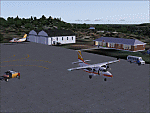
| Cape Verde Islands Domestic Airports |
|
Images related to this file:
File Description:
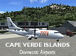
Googlyafcads and simple scenery for five airports in the Cape Verde Islands, all
of which are served by regular domestic flights of TACV - Transportes Aereos de
Cabo Verde. Each of these has been "overlooked" by Microsoft in Flight Simulator
2004 and are provided with nothing other than a runway. These scenery files add
aprons, taxiways, buildings and other airport features to Flight Simulator's bland
representation and allow you and "AI" traffic to land, taxi, park and take off
in a realistic manner.
The airports represented are: GVBA Rabil, GVMA Maio, GVSF Sao Filipe, GVSN Preguica and GVSV Sao Pedro.
The scenery does not purport to be ultra-accurate. Based on high-detail satellite
imagery from Google Earth (except Sao Filipe), the layout is proportianally correct
but the added airport features, such as buildings, are built from default Microsoft
objects and add-on libraries so will not look like the real thing. Sao Filipe is
largely imaginary owing to poor quality of the satellite image, but has been created
to be similar to other airports of like size.
You are not obliged to download and install any additional scenery libraries,
but to enjoy this scenery in its entirety, you may wish to. It will work fine,
with or without.
[File re-uploaded at request of AVSIM]
| Filename: | Cape_Verde_Islands_Domestic_Airports.zip |
| License: | Freeware |
| Added: | 15th June 2010, 01:00:46 |
| Downloads: | 6,994 |
| Author: | John Hinson |
| Size: | 84.1 KB |
| Category: Flight Simulator 2004 - Scenery | |
| WIKD/WIOD Tanjung Pandan/Buluh Tumbang/H.A.S. Hanandjoeddin, Indonesia |
|
File Description:
Googly scenery for WIKD/WIOD Tanjung Pandan/Buluh Tumbang/H.A.S. Hanandjoeddin,
Indonesia, based on Google Earth satellite data. It is a small domestic airport
serving the island of Belitung, located about 17 miles from the main town of the
island - Tandjungpandan. The island produces mainly tin and pepper but there are
some beaches that are generating tourist traffic too.
Flight Simulator 2004 has made no provision for any traffic at this airport and
this scenery seeks to redress the situation. The airport sees daily scheduled
traffic operated by Batavia Air and Sriwijaya Air.
The scenery does not purport to be ultra-accurate. Based on poor quality
satellite imagery from Google Earth, the layout is proportionally correct but the
added airport features, such as buildings, are built from default Microsoft objects
and add-on libraries so will not look exactly like the real thing.
You are not obliged to download and install any additional scenery libraries,
but to enjoy this scenery in its entirety, you may wish to. It will work fine,
with or without.
The ICAO code for this airport has recently changed from WIKD to WIOD. The included
files allow you to either retain the old code or optionally change the airport to
use the new one.
| Filename: | WIKDWIOD_Tanjung_PandanBuluh_TumbangHAS_Hanandjoed.zip |
| License: | Freeware |
| Added: | 22nd February 2008, 09:19:27 |
| Downloads: | 1,773 |
| Author: | John Hinson |
| Size: | 64.96 KB |
| Category: Flight Simulator 2004 - Scenery | |
| EHAM - Moving Traffic v0.5 |
|
File Description:
This project contains moving traffic around Schiphol Airport (EHAM). There are 4 types of cars and more than 10 colour schemes.
With this project there is just 1 problem:
Traffic will only appear in the first half of the hour. This time is the time of FS, not your system time. After 30 minutes of traffic all cars will disappear. The next 30 minutes it's rather quiet. This means a traffic density of zero. After this 30 minute period, it's rush (half)hour again. This repeats itself.
We don't know the problem yet, but any help is welcome. Some minor problems will be fixed later. This version (v0.5) is the release version because we don't want you to wait any longer.
We hope you'll enjoy this addon in spite of this problem. For other projects or updates: ProjectX
| Filename: | EHAM__Moving_Traffic_v05.zip |
| License: | Freeware |
| Added: | 22nd April 2005, 15:51:58 |
| Downloads: | 5,957 |
| Author: | Paul Koopman, André Koopman, ProjectX |
| Size: | 462.81 KB |
© 2001-2026 AVSIM Online
All Rights Reserved
Privacy Policy |