
Where Flight Simulation Enthusiasts Gather from Around the World!
AVSIM Library - Search Results

| Category: Flight Simulator 2004 - Scenery | |
| UUEE Moscow Sheremetyevo 2015 DEMO |

|
Images related to this file:
File Description:
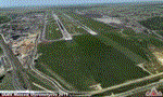
UUEE MOSCOW SHEREMETYEVO 2015 DEMO is a scenery of UUEE Sheremetyevo airport in Moscow, Russia, fully compatible with FS2004.
This product is a fully functional DEMO version of the commercial payware product. Most objects are modelled as in the full version but covered with low resolution textures. Using this free demo ensures no problems with online (VATSIM, IVAO, multiplayer etc.) flying in case some users use the payware scenery and some don't.
Moscow is the capital city and the most populous federal subject of Russia. The city is a major political, economic, cultural and scientific center in Russia and in Eastern Europe. Sheremetyevo International Airport (SVO/UUEE) is an international airport located in Khimki, Moscow Oblast. It is a hub for passenger operations of the Russian international airline Aeroflot, and is one of the three major airports that serve Moscow, along with Domodedovo International Airport and Vnukovo International Airport
The product is equipped with an automatic installer, which means that the scenery will be automatically added to the Flight Simulator Scenery Library. Please uninstall all previous versions of this airport you may have installed before. Please make also sure that no duplicated AFCAD files are installed.
Enjoy your virtual flying with Drzewiecki Design!
| Filename: | UUEE_Moscow_Sheremetyevo_2015_DEMO.zip |
| License: | Commercial demo |
| Added: | 4th April 2016, 21:52:46 |
| Downloads: | 847 |
| Author: | Drzewiecki Design |
| Size: | 13.68 MB |
| Category: Flight Simulator 2004 - Scenery | |
| Exploring Our World - Part 2 - Easter Island, Chile - SCIP - a complete makover. |
|
File Description:
Exploring Our World - Part 2 - Easter Island, Chile. In part two of this new series you will find a complete makeover of Easter Island which MS virtually ignored. Designed to compliment the fine Mataveri International Airport by Daniel Rojas (scip_o7.zip at Flightsim.com), this package includes Mesh and adjusted coastlines by John Young. John has also provided a new Afcad which removes unrealistic pushback starts. A new landclass file by John Burford adds the villages near the airport and more realistic ground treatments. You will also find numerous scenery enhancements using objects from the RWY12 and EZ Scenery libraries. Francisco Vargas has contributed a set of Thermals which soaring fans will enjoy. Of special interest is the use of AI Volkswagens, as taxi's driving around the airport and AI Helicopters that take visiting tourists on sightseeing tours. The AI Volkswagens have been provided by Ranier Girbig and are used with his permission. Easter Island, home of the mysterious head statues (Moai) has many new and exciting things just waiting for you to explore. Even the small adjacent Moto Nui Island, which MS forgot, has been added. This is the second of a series exploring lesser known parts of our FS world. Please unzip (using folders option) to a temporary folder and follow the documentation very carefully to assure a proper installation. ......
| Filename: | Exploring_Our_World__Part_2__Easter_Island_Chile__.zip |
| License: | Freeware |
| Added: | 13th July 2006, 03:22:45 |
| Downloads: | 6,691 |
| Author: | David "Opa" Marshall and friends |
| Size: | 6.7 MB |
| Category: Flight Simulator 2004 - Scenery | |
| Union Island TVSU in the Grenadines, eastern Caribbean Version 1.1 |
|
Images related to this file:
File Description:
This is a self-contained version 1.1 that modifies the terrain flattens around the airport. I found that suddenly, and for no apparent reason, the Lesser Antilles mesh and my flattens were at war and creating hills within the airport boundary. If you are not having problems then you do not need this.
Union Island is in the southern tail of the chain of islands known as St Vincent and the Grenadines, between Canouan and Carriacou. Union is another small island, 3.5 miles long and at its widest 1.5 miles wide; the resident population is around 3,000, mostly in the two towns Clifton and Ashton. The airport is at the eastern end of the island, and has been extended into the sea on landfill. The runway is now around 2,480 feet long, aligned 08 (and with the southeast trade winds it is unlikely that you will find yourself using 26) and with a displaced threshold of 530 feet due to the hill to the west. The terminal is adjacent to a rather small apron; there is parking on the grass north of the taxiway. There are connecting flights by SVG to Barbados and the other islands and these are reflected in the AI. The airport has no lighting, and flights are obliged to land and depart in daylight hours only, outside of which the airport is closed.
| Filename: | Union_Island_TVSU_in_the_Grenadines_eastern_Caribb.zip |
| License: | Freeware, limited distribution |
| Added: | 16th June 2013, 18:46:33 |
| Downloads: | 526 |
| Author: | Roger Wensley |
| Size: | 2.02 MB |
| Category: Flight Simulator 2004 - Scenery | |
| CD KnettishallFS9 |
|
Images related to this file:
File Description:
Description:
From June 1943 to August 1945, the 560th, 561st, 562nd and 563rd Bombardment Squadrons of the 388th Bombardment Group with B-17's, flew 331 missions (including 19 Aphrodite missions from Fersfeld) losing 179 B-17s. On 6 September 1943, the 388th lost 11 B-17's on a mission to Stuttgart including all the aircraft of the 563rd BS. The airfield was not used again and sold off in 1957.
This add-on is not compatible with VFR scenery. Sorry for that.
Included in the download is an AI traffic BGL file that makes this base come to life. To get this file working, you must have the Wings of Power Heavy Bombers and Jets add on installed. You must also have downloaded the two repaint set for the B-17 done by my friend Chuck Lawsen. This last file can be found here at Avsim, it�s called: wop_388_b17.zip This project is as always dedicated to all the brave young men that contributed to the effort of getting Europe out of the claws of a dark, perhaps the darkest period in modern history, but this time it is especially dedicated to 1st Lt. Ralph M. Reese, co-pilot 562nd Sqd., and of course all the brave men of the 388th.
Enjoy!
Cees Donker
| Filename: | CD_KnettishallFS9.zip |
| License: | Freeware |
| Added: | 10th May 2010, 05:26:25 |
| Downloads: | 425 |
| Author: | Cees Donker |
| Size: | 1.12 MB |
| Category: Flight Simulator 2004 - Scenery | |
| Kindley Field Bermuda 1955-1962 |
|
File Description:
Kindley Field, on the British Overseas Territory of Bermuda, was built as a joint RAF/USAAF facility during the Second World War. Subsequently the RAF area became the civilian terminal while Kindley Air Force Base was operated by the USAF between 1948 and 1970. It was primarily a staging post between the US and Western Europe for land-based planes unable to cross the Atlantic non-stop, very like Ernest Harmon in Newfoundland and the civilian Gander, and like Harmon it closed when the jet age made such bases redundant. Prior to that it hosted no combat units, but the 59th and then 53rd Weather Reconnaissance Squadrons, the 'Hurricane Hunters', were based there, and also from 1 February 1956 to 15 June 1963 the 303rd ARS Stratotankers were present to support Strategic Air Command and other refueling requirements. After 1970 it became a US Navy facility primarily concerned with tracking Soviet submarines, and was closed at the end of the Cold War. This scenery represents Kindley between 1955 and 1962 and has custom made scenery by Dan French and ai military traffic by Al Von Pingel to add to the downloadable California Classic civilian and MATS traffic available at Tom Gibson's site. Like Harmon and Gander, it was one of the most important airfields of its time.
| Filename: | Kindley_Field_Bermuda_19551962.zip |
| License: | Freeware |
| Added: | 3rd December 2022, 13:10:38 |
| Downloads: | 143 |
| Author: | Ken Lawson, Al Von Pingel, Dan French |
| Size: | 30.31 MB |
| Category: Flight Simulator 2004 - Scenery | |
| Lanseria International Airport (FALA), Johannesburg, South Africa |
|
Images related to this file:
File Description:
Lanseria international airport is Johannesburg's second international airport and mostly cater to private jets, low cost airlines and many private general aviation and flightschool aircraft. It is a privately owned airport and can accomodate aircraft up to the size of a Boeing 757-300. This airport has seen John Travolta use it with his Boeing 707, the Hilton family with a private Boeing 757 and even the USAF have landed their C-17 Globemasters at the airport when Air Force one came here in the past with the latter landing at AFB Waterkloof.
This package started out as a conversion of the wonderfull FSX scenery of the airport by Lee Hall and converted with permission from the original author. It quickly expanded however to a project that now additionally includes photoreal ground textures that changes with seasons, many added fences and gates around the airport, inclusion of the shaded parking areas with parked cars, static airplanes (RWY12 and EZ scenery libraries needed to see this) as well as numerous objects around the airport and apron made by myself in Gmax to give the airport some FS9 life.
Also included is the wonderfull "apron light splashes" by Hans Günther Schnell who kindly gave me permission to use it for the night times.
I have also included a local mesh for the area for users of FSGlobal 2010 to eliminate the extreme elevation anomoly around the airport.
| Filename: | Lanseria_International_Airport_FALA_Johannesburg_S.zip |
| License: | Freeware, limited distribution |
| Added: | 11th August 2023, 16:03:37 |
| Downloads: | 272 |
| Author: | Kobus van Wyk, Lee Hall |
| Size: | 37.64 MB |
| Category: Flight Simulator 2004 - Scenery | |
| Aasiaat BGAA on the west coast of Greenland |
|
Images related to this file:
File Description:
I wrote that Qikiqtarjuaq, on the east coast of Baffin Island, was the jumping off airfield for ferry flights for small planes from Canada to Europe via Greenland. Aasiaat is the airfield in Greenland that they jump to, 300 miles across the Davis Strait. The airfield is on the northern coast of Aasiaat Island, and the town of the same name is just two miles to the west. The runway is 2,600 feet of asphalt almost 100 feet wide and lit, at 74 feet ASL, aligned 12/30, with the apron and terminal building at the western end. Air Greenland run regular flights with a Dash-7 or 8, & Twin Otters, and the markings for the taxiway and parking spot in front of the terminal are exactly as they were six years ago. I have seen video since then that has further taxiway and parking spot markings added in, but I like the simplicity of the original. Unfortunately, given the limitations of FS and the single runway and simple taxiway routing there was no way to replicate both the parking facing away from the terminal AND the "through" taxiing to complete the circle back to the runway; after parking correctly the AI Air Greenland Dash-8 will reverse before heading out to take off. There is both JetA and 100LL fuel available. The surrounding area is rocky, and there is no grass around the runway; the airfield has compacted gravel instead.
| Filename: | Aasiaat_BGAA_on_the_west_coast_of_Greenland.zip |
| License: | Freeware, limited distribution |
| Added: | 26th March 2012, 11:01:16 |
| Downloads: | 690 |
| Author: | Roger Wensley |
| Size: | 2.73 MB |
| Category: Flight Simulator 2004 - Scenery | |
| Maurice Bishop TGPY on Grenada in the Caribbean |
|
Images related to this file:
File Description:
Grenada island is 17 miles south of the southernmost island of the Grenadines, Carriacou; there are some smaller islands between the two. Grenada is 18 miles long and around 8 miles wide, has an estimated population of 110,000, and produces a very large part of the world's annual nutmeg harvest. The capital, St Georges, is by far the largest town and is at the southern end of the island, with the airport close by.
The airport is now called Maurice Bishop, but for some years was called Point Salines. The runway is just over 9,000 feet long and oriented 10/28. Point Salines replaced Pearl Airport, which is on the east coast 12 miles northeast of St Georges and was difficult to expand as the runway had mountains at one end and the sea at the other. Pearl is now closed; it is included here but only as a visual landmark with "closed" markings. There are regular international flights from North America and Europe, some of which are seasonal only (Air Canada for instance) and local connecting flights by LIAT and SVG. I retained the default control tower as it is some distance away. In real life it is also some distance away and on a hill northwest of the terminal. Which is why I did not take photos from which I would have made the real one. The hill does not feature in FS9.
| Filename: | Maurice_Bishop_TGPY_on_Grenada_in_the_Caribbean.zip |
| License: | Freeware, limited distribution |
| Added: | 11th June 2013, 23:28:17 |
| Downloads: | 824 |
| Author: | Roger Wensley |
| Size: | 7.38 MB |
| Category: Flight Simulator 2004 - Scenery | |
| FS2004 Scenery--Goose Bay Canadian Forces Base and US Air Base. Goose Bay Canadian Forces Base and US Air Base (CYYR), Newfoundland and Labrador, Canada, 1955-62. |
|
File Description:
Goose Bay Canadian Forces Base and US Air Base (CYYR), Newfoundland and Labrador, Canada, 1955-62. Originally built to facilitate the transport of US aircraft to Europe during the Second World War, during the Cold War Goose Bay was a base of major importance. Like nearby Gander it was a vital refuelling point for transatlantic crossings, but also along with the recently released Ernest Harmon Air Base (CYJT) an important part of the defences against the threat of Soviet bombers carrying muclear weapons attacking the USA via the North Pole. F-89 Scorpions and then F-102 Delta Daggers were based there, and this download includes F-89s especially made for this scenery by David Wooster. Flight plans are provided for 1955, 1957, 1959 and 1962, doing much to recreate this significant Cold War base as it really was; many of the aircraft which passed through Goose at that time are provided for.
This file is an update to the scenery issued in October 2021, made necessary by the discovery of new information as a result of further historical research. There have also been changes to the ADE and traffic files intended to improve the performance of both, and to the navaids too. Instructions are included for those installing from scratch and those updating our previous version, and there have been improvements to the clarity of the instructions for the downloading and installation of the ai aircraft.
There will be no further updates.
| Filename: | FS2004_SceneryGoose_Bay_Canadian_Forces_Base_and_U.zip |
| License: | Freeware |
| Added: | 25th December 2021, 19:00:49 |
| Downloads: | 281 |
| Author: | Al Von Pingel, Dan French, Bill Douglas, Ken Lawson |
| Size: | 50.25 MB |
| Category: Flight Simulator 2004 - Scenery | |
| CYYQ - Churchill Port & York Factory - Northern Manitoba, Canada |
|
Images related to this file:
File Description:
The main part of this scenery installs the Port of Churchill and the grain silos. Churchill CYYQ has been made by Sidney Schwartz, and this also adds AI and slightly modifies his parking to make a space big enough for Buffalo's C46. Churchill is in northern Manitoba, on the Churchill River where it empties into Hudson Bay. The town is accesible by air, by boat (once the winter ice melts) and most importantly by rail from the south. Grain from the Canadian prairies is hauled north and stored in Churchill for export to Europe by a sea route that is significantly shorter than any other, and there is a grain carrier included in the AI. Today there are perhaps 810 people living in Churchill, a slowly declining number. There are also a number of impressive polar bears. There was another port south of Churchill, but it was never completed, never connected to a railroad track, and never used. It was called Port Nelson, and was at the mouth of the Nelson River. Nearby, on the Hayes River, there is an old trading post called York Factory, built in 1684 and preserved as part of the living history of the north of Canada. The second scenery is for this, and for the nearby tourist camp called Silver Goose Lodge, which as the name suggests is for hunters. The large grassy area alongside the fort was for the trappers to camp on when they all arrived in early summer to trade the furs for goods.
| Filename: | CYYQ__Churchill_Port__York_Factory__Northern_Manit.zip |
| License: | Freeware, limited distribution |
| Added: | 23rd July 2014, 02:26:04 |
| Downloads: | 542 |
| Author: | Roger Wensley |
| Size: | 3.69 MB |
© 2001-2026 AVSIM Online
All Rights Reserved
Privacy Policy |