
Where Flight Simulation Enthusiasts Gather from Around the World!
AVSIM Library - Search Results

| Category: Flight Simulator 2004 - Scenery | |
| Replacement Overcast Water Texture |

|
File Description:
The default milky "white/green" texture is highly unrealistic in very grey overcast conditions such as we often find here in Europe. The replacement texture will change this to a more convincing "blue/grey" cast. Version 2 has a darker blue/grey than my version 1 and presents a more realistic colour and in particular it's much improved in "dark overcast" conditions. Version 2 also offers better transitions from "overcast" conditions to "clear" conditions. It should be understood the default "milky green - overcast water texture" colour is dependant on the display settings. The replacement texture supplied will only work on DX9 compliant video cards. You must be able to move the "Water Effects" slider all the way to the right! If not then don't install them as you won't be able to see them!
| Filename: | Replacement_Overcast_Water_Texture.zip |
| License: | Freeware |
| Added: | 22nd December 2003, 21:08:19 |
| Downloads: | 1,055 |
| Author: | Peter Wilding |
| Size: | 668.32 KB |
| Category: Flight Simulator 2004 - Scenery | |
| BFU Brooks |
|
File Description:
With BFU Brooks, BFU enters the faraway bush country of northern Alaska. Located at Coldfoot in the southern foothills of the Brooks mountains, this base will cater to the needs of visitors to the area, and of sportsmen who indulge in hunting and fishing. This scenery package consists of three sceneries: our new northern base BFU Brooks, Moose Camp and Moose Lodge. The camp sits in the mountains on a small lake, whereas the lodge is situated on the shore of a large lake. Visitors are flown into Coldfoot from Fairbanks, then on to the camp or lodge as desired. Moose Camp and Moose Lodge will not show on the GPS, and of course do not have an NDB or similar to guide you. You'd better start in the camp/lodge, and fly toward Coldfoot to get to know the area. The sceneries have only been tested with the default mesh.
| Filename: | BFU_Brooks.zip |
| License: | Freeware |
| Added: | 30th September 2003, 15:17:31 |
| Downloads: | 5,313 |
| Author: | Naji Chehabeddine |
| Size: | 2.96 MB |
| Category: Flight Simulator 2004 - Scenery | |
| Kerkira Airport Enhancement |
|
File Description:
This is old scenery which has been updated for FS2004 and enhances the visual environment of Ionian sea island airport of Kerkira, also known as Corfu. Its part of my “Greek Airfields” package that currently is not fully compatible with FS2004 since MS decided to move the airports in Greece and elsewhere to adjacent positions and ASD, which I use for placing these objects, is not compatible with FS2004. Here you will find airport & terrain enhancements for Hellenic airport of Kerkira LGKR that make it look closer to the real one; hotels, runway turning bay, perimeter fences, windsocks, radio antennae, new approach radar antenna to the southwest and most importantly, an exclusion of autogen scenery that is wrongfully generated on each side of the runway. A big difference is attributed to Babis Peribolas’s Kerkira mesh terrain that is included in this scenery. Scenery includes the necessary ASD 2.1 textures.
| Filename: | Kerkira_Airport_Enhancement.zip |
| License: | Freeware, limited distribution |
| Added: | 4th September 2003, 02:23:06 |
| Downloads: | 12,173 |
| Author: | Kyprianos Biris |
| Size: | 1.94 MB |
| Category: Flight Simulator 2004 - Scenery | |
| Argyle International Airport, Saint Vincent |
|
Images related to this file:
File Description:
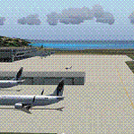
This is a scenery created by me of the soon to be completed Argyle International Airport on the island nation of Saint Vincent and the Grenadines. This scenery was created as a pet project of mine out of personal love for the project. The airport was created using only default scenery objects and the only thing that was changed was the type and direction of the turning point at the RWY04 end. I'm sharing this so FS2004 simmers can see what the airport will be like on completion. The scenery is 100% customizable to suit your preference. All I ask is that you don't change the actual airport design. I hope that this will bring you hours and hours of flying fun.
Important: This scenery requires the full RWY12 Scenery Library including the Gate Markings SS files. Also the Lesser Antilles Mesh is required.
| Filename: | Argyle_International_Airport_Saint_Vincent.zip |
| License: | Freeware |
| Added: | 22nd December 2013, 21:57:40 |
| Downloads: | 528 |
| Author: | Cilbert Campbell |
| Size: | 6.8 KB |
| Category: Flight Simulator 2004 - Scenery | |
| Revised East Vancouver Islands - compatible with vicenh05 |
|
File Description:
These files are a revision of the default Vancouver Island shorelines and landclass textures from Chemainus to Campbell River, British Columbia. Included are the islands from the Southern Gulf Islands to Texada Island and inland to Cowichan Lake. Most of the smaller lakes within 20 km of the shoreline have been redrawn as well. In this version shorelines have been revised to match Jon Patch & Holger Sandman's vicenh05.zip. As well major corrections for the shorelines in LOD5 area 117-114, Comox, have been made so that the shorelines now conform to the 38.2m mesh and to Vern Opperman's CFB - Comox version 042. Shoreline types are changed to look more like the Pacific Northwest courtesy of Holger Sandman's who made his shoreline textures for vicenh05 available. Also in this version no roads are included since complete British Columbia roads in bcroadsys.zip are now available.
| Filename: | Revised_East_Vancouver_Islands__compatible_with_vi.zip |
| License: | Freeware, limited distribution |
| Added: | 8th October 2005, 20:17:46 |
| Downloads: | 3,925 |
| Author: | Harvey Janszen |
| Size: | 346.85 KB |
| Category: Flight Simulator 2004 - Scenery | |
| Bora Bora Airport, French Polynesia, NTTB |
|
File Description:
The Bora Bora airport is located on one of the Motus, which surround the Island of Bora Bora. The Motus are raised coral reefs which act as break waters, and create the beautiful turquoise lagoons which surround the French Polynesian Islands. This scenery is a complete remake of the original, and is now much more accurate as to what the airport looks like. It contains the main terminal, a fire station attached to the tower with fuel tanks, open air hangar structures, two helipads, and wood stairs taking you down to the boat docks where you are transported to the main island. This is one of the most unique French Polynesian Islands with it's beautiful and interesting mountain structure. Using the terrain mesh by Rolf Keibel and John Applegate will tremendously enhance this part of the world in FS. It is available at Flightsim under the name fpsimesh.zip. Afcad by Ray Smith is also included.
| Filename: | Bora_Bora_Airport_French_Polynesia_NTTB.zip |
| License: | Freeware |
| Added: | 25th April 2004, 01:39:17 |
| Downloads: | 19,350 |
| Author: | Bill Melichar |
| Size: | 3.11 MB |
| Category: Flight Simulator 2004 - Scenery | |
| Exploring Our World - Part 1. Canaima Park - Canaima Airport (SCVN) - Angel Falls, Venezuela |
|
Images related to this file:
File Description:

Exploring Our World - Part 1. Canaima Park - Canaima Airport (SCVN) - Angel Falls, Venezuela. Visit the worlds highest waterfall (16 times higher than Niagara) - one of the Natural Wonders of the World!
This new package features David Maldonado's excellent Mesh of Canaima Park in Venezuela and a very special "animated" depiction of Angel Falls by Ron Jeffers. The Canaima Airport has been enhanced using EZ Scenery libraries. There is also an optional Lago sound file created by Lou Frost. A brief history of Angel Falls along with a suggested tour of the area is included. You will also find a flight plan for use with the FSNavigator program. This is the first of a projected series exploring lesser known parts of our FS world. Please unzip (using folders option) to a temporary folder and follow the instructions very carefully.
This project was compiled for your flying enjoyment by David "Opa" Marshall.
| Filename: | Exploring_Our_World__Part_1_Canaima_Park__Canaima_.zip |
| License: | Freeware |
| Added: | 31st October 2009, 10:36:18 |
| Downloads: | 3,254 |
| Author: | David "Opa" Marshall |
| Size: | 3.22 MB |
| Category: Flight Simulator 2004 - Scenery | |
| Canlaon Volcano Eruption Scenery |
|
File Description:
Canlaon Volcano is located at the center of Negros Island,Philippines.The twin-peaked massif of Canlaon Volcano (aka Mt. Kanlaon) rises 2,465 meters above the island of Negros just 40-km southwest of the capital Bacolod.This file will add the crater to Canlaon Volcano and will enhance the Landclass surrounding the crater.The crater is real with water.This also adds Visual Effects such as steam,volcanic ashes and lava that will erupt every now and then.Ash falls will fall in the vulnerable surrounding villages of Pula, Malaiba, and Lumanao.The last volcanic activity of Canlaon Volcano recorded by Phivolcs was on June 1-18,2003.
Fly from Bacolod City(RPVB)to Tagbilaran City(RPVT)or Mactan(RPVM) and pass through the highest point of the Island of Negros and behold the beauty of the Canlaon Volcano eruption.
Special steam,ash,and lava effects are visible at daytime and at nighttime.The new Philippine Mesh by Jacques Marie is recommended for achieving realistic topography.You may find it here at avsim,too.
| Filename: | Canlaon_Volcano_Eruption_Scenery.zip |
| License: | Freeware |
| Added: | 10th December 2003, 22:41:38 |
| Downloads: | 3,876 |
| Author: | Ver Walter L. Gulfan |
| Size: | 5.04 KB |
| Category: Flight Simulator 2004 - Scenery | |
| Ontario Small Fields in Canada: #04 Stoney Point (Le Cunff) CRML V1 |
|
Images related to this file:
File Description:
This is the fourth in a series of small airfields in southern Ontario, Canada. It is Stoney Point (Le Cunff) CRML, a field near a small town (Stoney Point) close to Lake St Clair. The airfield has a grass runway of 2,250 feet, aligned 18/36; with trees around the house gardens between road and runway the south threshold is displaced by 250 feet. The markers approximately show the touchdown point north of the runway end. Le Cunff is the family name of the owners, included to differentiate between this and another Stoney Point field, CRJ2. I found the default FS9 airfield at the correct elevation of 625 feet, but sitting on a plateau, despite my Genesis Mesh. This looked so unreal that I have revised this to an incorrect lower elevation of 580. So if you find the airfield sitting in a hole in your installation you now know the reason. Let me know, with a screenshot please.
| Filename: | Ontario_Small_Fields_in_Canada_04_Stoney_Point_Le_.zip |
| License: | Freeware, limited distribution |
| Added: | 29th July 2015, 16:08:32 |
| Downloads: | 146 |
| Author: | Roger Wensley |
| Size: | 1.6 MB |
| Category: Flight Simulator 2004 - Scenery | |
| FS2004 Ernest Harmon Air Force Base and Stephenville Airport CYJT |
|
File Description:
FS2004 Scenery--Ernest Harmon Air Force Base and Stephenville Airport (CYJT), Newfoundland, 1957-62. Originally built to facilitate the transport of US aircraft to Europe during the Second World War, during the Cold War Harmon was the biggest US base outside the USA. Like nearby Gander it was a vital refuelling point for transatlantic crossings, but also an important part of the defences against the threat of Soviet bombers carrying muclear weapons attacking the USA via the North Pole. F-89 Scorpions and then F-102 Delta Daggers were based there, and this download includes F-89s especially made for this scenery by David Wooster. It also has custom landclass adjustments by Al Von Pingel and many custom buildings by Dan French. Flight plans are provided for 1957, 1959 and 1962, doing much to recreate this significant Cold War base as it really was. By Al Von Pingel, Dan French and Ken Lawson.
| Filename: | FS2004_Ernest_Harmon_Air_Force_Base_and_Stephenvil.zip |
| License: | Freeware |
| Added: | 10th October 2021, 17:08:19 |
| Downloads: | 210 |
| Author: | Al Von Pingel, Dan French and Ken Lawson |
| Size: | 23.96 MB |
© 2001-2026 AVSIM Online
All Rights Reserved
Privacy Policy |