
Where Flight Simulation Enthusiasts Gather from Around the World!
AVSIM Library - Search Results

| Category: Flight Simulator 2004 - Scenery | |
| Sitterdorf (LSZV) for Suisse 2004 |

|
File Description:
New airport for Suisse 2004. Works for FS2002 and fully compatible with FS2004. Includes 2 airport files depending of the mesh you use. Please read the doc. Features usual goodies of Suisse 2004 : seasonal textures, smoke effect, VAC chart, integrated ground texture, etc. Sitterdorf is a small private airfield far East of Switzerland. It has 2 minicars tracks and a small fun park.
| Filename: | Sitterdorf_LSZV_for_Suisse_2004.zip |
| License: | Freeware |
| Added: | 7th March 2004, 17:27:39 |
| Downloads: | 7,067 |
| Author: | Daniel Gauthier |
| Size: | 5.88 MB |
| Category: Flight Simulator 2004 - Scenery | |
| NZ Rural Airstrips Vs4 |
|
Images related to this file:
File Description:

This replaces my previous rural strips sceneries. A series of rural airstrips, (some with sloping runways), based on actual locations around New Zealand. This batch adds strips to the northern area of New Zealand's South Island. You must have Christian Stock's NZ mesh in the form of "Mountains of New Zealand" and topo in the form of "Lakes and Rivers of New Zealand".
| Filename: | NZ_Rural_Airstrips_Vs4.zip |
| License: | Freeware |
| Added: | 1st May 2010, 07:33:37 |
| Downloads: | 381 |
| Author: | Godfrey Tier |
| Size: | 2.67 MB |
| Category: Flight Simulator 2004 - Scenery | |
| Roxburgh Aerodrome - NZRX |
|
Images related to this file:
File Description:
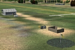
Situated between Dunedin and Queenstown, New Zealand. An important centre during the Central Otago goldrush of the 1860s, in more recent times Roxburgh has relied on a mixture of livestock and
stone fruit production. Roxburgh Trotting Club.
Made for Christian Stock's NZ mesh in the form of "Mountains of New Zealand" and topo in the form of "Lakes and Rivers of New Zealand".
| Filename: | Roxburgh_Aerodrome__NZRX.zip |
| License: | Freeware |
| Added: | 12th January 2011, 02:59:10 |
| Downloads: | 273 |
| Author: | Godfrey Tier |
| Size: | 1.28 MB |
| Category: Flight Simulator 2004 - Scenery | |
| Hamilton City 2006 V1 |
|
File Description:
Hamilton City 2006 V1 is a photo real city adding over 30 odd custom built buildings for the Hamilton city area and a heliport at the Waikato hospital
this can be used with or without add ons such as robin corns godzone hamilton realnz photoreal landclass,best used with real hamilton and with a good mesh but not nessesary ,
enjoy..
| Filename: | Hamilton_City_2006_V1.zip |
| License: | Freeware |
| Added: | 11th December 2006, 03:23:21 |
| Downloads: | 1,712 |
| Author: | Mike Allen-Andrews |
| Size: | 3.26 MB |
| Category: Flight Simulator 2004 - Scenery | |
| Quebec sceneries Enhancements Update |
|
File Description:
Enhanced sceneries and mesh update of the province of Quebec, Canada. Must be used with
Scenes_du_Quebec_2k4.zip and qc09_2K4a.zip, qc09_2K4b.zip, qc09_2K4c.zip,
qc09_2K4d.zip files (AVSIM files library).Installation procedure in INSTALLATION_SETUP.txt.
Mise � jour et nouvelles sc�¨nes de la province de Qu�©bec. Pour utiliser cette mise � jour, il faut obligatoirement avoir d�©j� install�© les sc�¨nes du Qu�©bec contenues dans Scenes_du_Quebec_2k4.zip (sur AVSIM). Inclus aussi une mise � jour des �©l�©vations de terrain (mesh - lod09) de la province de Qu�©bec (qc09_2K4a.zip, qc09_2K4b.zip, qc09_2K4c.zip, qc09_2K4d.zip sur AVSIM). L'installation des fichiers est d�©crite dans INSTALLATION_SETUP.txt.
| Filename: | Quebec_sceneries_Enhancements_Update.zip |
| License: | Freeware, limited distribution |
| Added: | 1st November 2009, 06:49:03 |
| Downloads: | 4,759 |
| Author: | Gilles Gauthier |
| Size: | 6.81 MB |
| Category: Flight Simulator 2004 - Scenery | |
| New Terrain Mesh of the Province of Quebec in LOD09 (1/4) |
|
File Description:
The files in this package contain terrain mesh files of the province of Quebec (N45 to N53) to be used with my Quebec enhanced sceneries for FS2004 (Scenes_du_Quebec_2k4.zip). The public data sources are the Shuttle Radar Topography Mission (SRTM-3, 90m) and the Canadian Digital Elevation Data (CDED - 0.75s/arc - 23m). (QC09_2k4a.zip to QC09_2k4d.zip - 4 parts)
***********************
Les fichiers de ces archives contiennent les donnees d'elevation de terrain (mesh files - lod09), pour FS2004, du territoire de la province de Quebec sous le 53ieme degre de latitude nord. Ils ont ete crees pour etre utilises avec mes nouvelles scenes du Quebec contenues dans Scenes_du_Quebec_2k4.zip. Les donnees sources sont du domaine public et proviennent de la Shuttle Radar Topography Mission (SRTM-3, 90m) et des donnees numerique d'elevation du Canada (DNEC - 0.75s/arc -23 m). (QC09_2k4a.zip to QC09_2k4d.zip - 4 parties)
| Filename: | New_Terrain_Mesh_of_the_Province_of_Quebec_in_LOD09_14.zip |
| License: | Freeware, limited distribution |
| Added: | 27th January 2010, 18:10:18 |
| Downloads: | 8,915 |
| Author: | Gilles Gauthier |
| Size: | 23.76 MB |
| Category: Flight Simulator 2004 - Scenery | |
| New Terrain Mesh of the Province of Quebec in LOD09 (2/4) |
|
File Description:
The files in this package contain terrain mesh files of the province of Quebec (N45 to N53) to be used with my Quebec enhanced sceneries for FS2004 (Scenes_du_Quebec_2k4.zip). The public data sources are the Shuttle Radar Topography Mission (SRTM-3, 90m) and the Canadian Digital Elevation Data (CDED - 0.75s/arc - 23m). (QC09_2k4a.zip to QC09_2k4d.zip - 4 parts)
***********************
Les fichiers de ces archives contiennent les donnees d'elevation de terrain (mesh files - lod09), pour FS2004, du territoire de la province de Quebec sous le 53ieme degre de latitude nord. Ils ont ete crees pour etre utilises avec mes nouvelles scenes du Quebec contenues dans Scenes_du_Quebec_2k4.zip. Les donnees sources sont du domaine public et proviennent de la Shuttle Radar Topography Mission (SRTM-3, 90m) et des donnees numerique d'elevation du Canada (DNEC - 0.75s/arc -23 m). (QC09_2k4a.zip to QC09_2k4d.zip - 4 parties)
| Filename: | New_Terrain_Mesh_of_the_Province_of_Quebec_in_LOD0.zip |
| License: | Freeware, limited distribution |
| Added: | 1st November 2009, 06:47:09 |
| Downloads: | 4,627 |
| Author: | Gilles Gauthier |
| Size: | 27.78 MB |
| Category: Flight Simulator 2004 - Scenery | |
| New Terrain Mesh of the Province of Quebec in LOD09 (3/4) |
|
File Description:
The files in this package contain terrain mesh files of the province of Quebec (N45 to N53) to be used with my Quebec enhanced sceneries for FS2004 (Scenes_du_Quebec_2k4.zip). The public data sources are the Shuttle Radar Topography Mission (SRTM-3, 90m) and the Canadian Digital Elevation Data (CDED - 0.75s/arc - 23m). (QC09_2k4a.zip to QC09_2k4d.zip - 4 parts)
***********************
Les fichiers de ces archives contiennent les donnees d'elevation de terrain (mesh files - lod09), pour FS2004, du territoire de la province de Quebec sous le 53ieme degre de latitude nord. Ils ont ete crees pour etre utilises avec mes nouvelles scenes du Quebec contenues dans Scenes_du_Quebec_2k4.zip. Les donnees sources sont du domaine public et proviennent de la Shuttle Radar Topography Mission (SRTM-3, 90m) et des donnees numerique d'elevation du Canada (DNEC - 0.75s/arc -23 m). (QC09_2k4a.zip to QC09_2k4d.zip - 4 parties)
| Filename: | New_Terrain_Mesh_of_the_Province_of_Quebec_in_LOD0.zip |
| License: | Freeware, limited distribution |
| Added: | 27th January 2010, 18:15:12 |
| Downloads: | 7,495 |
| Author: | Gilles Gauthier |
| Size: | 29.35 MB |
| Category: Flight Simulator 2004 - Scenery | |
| New Terrain Mesh of the Province of Quebec in LOD09 (4/4) |
|
File Description:
The files in this package contain terrain mesh files of the province of Quebec (N45 to N53) to be used with my Quebec enhanced sceneries for FS2004 (Scenes_du_Quebec_2k4.zip). The public data sources are the Shuttle Radar Topography Mission (SRTM-3, 90m) and the Canadian Digital Elevation Data (CDED - 0.75s/arc - 23m). (QC09_2k4a.zip to QC09_2k4d.zip - 4 parts)
***********************
Les fichiers de ces archives contiennent les donnees d'elevation de terrain (mesh files - lod09), pour FS2004, du territoire de la province de Quebec sous le 53ieme degre de latitude nord. Ils ont ete crees pour etre utilises avec mes nouvelles scenes du Quebec contenues dans Scenes_du_Quebec_2k4.zip. Les donnees sources sont du domaine public et proviennent de la Shuttle Radar Topography Mission (SRTM-3, 90m) et des donnees numerique d'elevation du Canada (DNEC - 0.75s/arc -23 m). (QC09_2k4a.zip to QC09_2k4d.zip - 4 parties)
| Filename: | New_Terrain_Mesh_of_the_Province_of_Quebec_in_LOD0.zip |
| License: | Freeware, limited distribution |
| Added: | 27th January 2010, 18:17:08 |
| Downloads: | 7,854 |
| Author: | Gilles Gauthier |
| Size: | 20.94 MB |
| Category: Flight Simulator 2004 - Scenery | |
| Coolangatta International |
|
File Description:
Coolangatta Airport(YBCG) aka Gold Coast Airport, Queensland, AUSTRALIA.
This is an expanding and busy airport servicing all capitals and regional centres within Australia as well as international flights to New Zealand. The GA area is also busy particularly when international events such as Indy are being staged.
This revised scenery now works perfectly with Ross Cassey's excellent SE Qeensland landclass. Included is a subset of Ross's landclass with an extra landclass of my own extending the South Gold Coast suburbs. If you do not have the full version of Ross's SEQ landclass you should make it your next download - it brings new dimensions to this area. Full night lighting is included and I recommend you try a night flight the Gold Coast looks very realistic with the new land classes. A new control tower has been added with rotating night time beacon.
AFCAD files and AI traffic files are included.
| Filename: | Coolangatta_International.zip |
| License: | Freeware |
| Added: | 5th February 2004, 16:32:00 |
| Downloads: | 8,987 |
| Author: | John Ross |
| Size: | 10.23 MB |
© 2001-2026 AVSIM Online
All Rights Reserved
Privacy Policy |