
Where Flight Simulation Enthusiasts Gather from Around the World!
AVSIM Library - Search Results

| Category: Flight Simulator 2004 - Scenery | |
| PHNL - Honolulu Intl - Hawaii, USA |

|
Images related to this file:
File Description:
This is a total remake of the Honolulu Intl airport except for the Hickham AFB side. Parking is included for the military side but no buildings at the present time. That is for a later project. All buildings were were designed using Instant Object Studio and using ADE9 for the layout. Would like to thank Sidney Schwartz for allowing me to use his textures and buildings with this scenery. Also, the other scenery designers, Lars Hoyer, Steve Ziegler, Dennis Waggoner, Kevin Wynn, Matthew Tomkins for their libraries used to make this scenery. Plus any others I may not have mentioned. See the readme file for additional libraries needed to complete the scenery. This is my first scenery to build for upload so hopefully everyone will enjoy.
| Filename: | PHNL__Honolulu_Intl__Hawaii_USA.zip |
| License: | Freeware |
| Added: | 13th October 2014, 16:20:15 |
| Downloads: | 4,050 |
| Author: | Johnny Alford |
| Size: | 18.97 MB |
| Category: Flight Simulator 2004 - Scenery | |
| KSBA New JUN08 AFCAD w/ Al Wheeler's objects |
|
File Description:
Contemporary KSBA, Santa barbara Municiple Airport scenery as of June 2008 with Scenery object by Al Wheeler.With wheeler's scenery objects, this scenery is packed individually, ready to use by itself. Installtion guide included. Changes included: 1) New taxiway M, K & P
2) original Alpha 07 end curve became P and A extended to the end of rwy 25
but the length of 25 did not change becuse it is "moved forward"
3) J and G near 25 is widen
4) 3 Helipads
5) Grass sides
6) closed link on the end of A and D
7) added taxi signs, you will never get lost a gain
hope you like it and log in to KSBA in vatsim - By James Luen
| Filename: | KSBA_New_JUN08_AFCAD_w_Al_Wheelers_objects.zip |
| License: | Freeware |
| Added: | 16th June 2008, 19:43:14 |
| Downloads: | 1,864 |
| Author: | James Luen |
| Size: | 5.46 MB |
| Category: Flight Simulator 2004 - Scenery | |
| Beaver Creek CYXQ in Yukon Territory, Canada |
|
Images related to this file:
File Description:
Beaver Creek is located at mile 1202 of the Alaska Highway, just east of the Alaska/Yukon border. The populaton is around 100 and the main employment is with the Border Agency, the White River First Nation, or with local tourist lodges. The airfield is a mile north of the town and close to the Canadian border post, which is included in the scenery. It was built by Jack Stalberg in the 1960's, and I have no further information beyond the fact that he loved to fly. The airport serves as an "airport of entry", though it is restricted in hours of opening and in the size of aircraft that it can handle; up to a maximum of only 15 seats. The single runway is 3,745 feet long and 100 feet wide, gravel, aligned 13-31 in FS9, lit, and with vasi at both ends. Righthand circuits for runway 13. There is a 340 feet threshold displacement to runway 31, which is of course unmarked on a gravel runway. The terminal building was recently reclad; I don't like it, but they didn't consult me. The ai reflects the sort of traffic the airfield gets; ie brief paperwork stopovers for GA or small charter flights into Canada from Alaska, usually in the mornings.I have adjusted the local scenery terrain levels to remove adjacent hills that I believe do not exist in real life but are part of the Northern Canada terrain mesh that I have installed. If you do not have this mesh you may find that the scenery works fine for you without the API flatten that is included here. The airfield is at 2,129 feet ASL.
| Filename: | Beaver_Creek_CYXQ_in_Yukon_Territory_Canada.zip |
| License: | Freeware, limited distribution |
| Added: | 28th January 2019, 06:19:20 |
| Downloads: | 177 |
| Author: | Roger Wensley |
| Size: | 4.68 MB |
| Category: Flight Simulator 2004 - Scenery | |
| Fort Nelson CYYE in British Columbia, Canada |
|
Images related to this file:
File Description:
Fort Nelson is close to the Peace River in the northeast corner of British Columbia, around 70 miles from the northern border, 90 from the eastern border, and 80 miles east of the Rockies. The wartime construction of the Alaska Highway actually started from Fort Nelson, as there was already a road from Fort St John (which is close to Dawson Creek) north to Fort Nelson. The airfield was part of this construction effort and after the wartime ferrying of planes to Russia it was used by the US Army Air Force and then by the Canadian Air Force. Fort Nelson flourished with the oil and gas exploration of the 1950's and the following years, and this continued to grow until the collapse of the oil price in 2014.
The town of Fort Nelson became the capital of the Northern Rockies Regional District when it was founded in 2009, and as a result the official name of the Fort Nelson airport is the Northern Rockies Regional Airport. The date for this scenery is around 2016, by which time the economic fortunes of the town were in decline. Five times per day flights by Central Mountain Air were starting to be reduced in number to the current (in 2022) one per day and none on Sunday; in the AI included here there are two flights per day. The main resident users of the airport are four helicopter companies, the helicopters presumably used for maintenance trips to whatever parts of the oil and gas fields that are still in use in the surrounding area.
There are two runways, the main one is aligned 03-21, 6,400 feet long and 200 feet wide, with ILS at the southern end and PAPI at the northern. The second runway (a narrower rebuild on a previously existing runway) is aligned 07-25 and 77 feet wide, and is without any lights. These are the alignments as per the original build of FS9 and not as per the approximate 2016 date of the buildings; I had a problem at a very late stage in making this scenery which prevented me from continuing with some final details.
On YouTube there is a series of posts by Angle of Attack showing the preparation and then the flight of an old Cessna 172 from Homer to Oshkosh for the installation of modern instruments. Interesting for me as they visit or fly over airfields I have made (Homer, Merrill, Tok Junction, Burwash, Silver City, Haines Junction, Watson Lake, Fort Nelson, and Grande Prairie) but in the winter so it all looks very different.
| Filename: | Fort_Nelson_CYYE_in_British_Columbia_Canada.zip |
| License: | Freeware, limited distribution |
| Added: | 23rd January 2022, 20:11:18 |
| Downloads: | 188 |
| Author: | Roger Wensley |
| Size: | 28.35 MB |
| Category: Flight Simulator 2004 - Scenery | |
| FREEflow Bermuda v1.3 |
|
File Description:
FREEflow Bermuda is a FREE scenery addon for Microsoft Flight Simulator: ACOF which will transform the Islands of Bermuda. Features include: Land class scenery which accurately reflects vegetation and population of the Islands of Bermuda. Water class scenery which properly reflects vibrant tropical reefs of Bermuda. Completely new ocean coasts, bays, and ponds accurately placed using Landsat imagery. All new detailed Bermuda International Airport (TXKF) with accurate AFCAD. Accurately placed, custom GMax models for many landmarks in Bermuda, including both lighthouses and many historic buildings. All major roads, highways and bridges. AI surface traffic including a custom designed ferry system with accurate scheduling, and many others. A configuration utility to tailor this scenery to your system and personal preferences. v1.3 adds taxiway signs to TXKF and addresses a number of minor problems.
| Filename: | FREEflow_Bermuda_v13.zip |
| License: | Freeware, limited distribution |
| Added: | 7th October 2005, 18:38:50 |
| Downloads: | 13,351 |
| Author: | FS-FREEflow (Scott Gridley, Joe Watson, Jim Campisi, Ron Jeffers, Bob Brown, Barry Wells) |
| Size: | 19.77 MB |
| Category: Flight Simulator 2004 - Scenery | |
| Emerald Lake |
|
File Description:
"Emerald Lake" (YEWA), Queensland, Australia.
Emerald Lake is the international headquarters and home base for EastWest Airlines VA and is situated 18 kilometres from Emerald. Emerald Lake is nestled on the foreshores of Lake Maraboon, Queensland's second largest lake. It is 265 km west of Rockhampton and 900km from Brisbane. The lake is a massive 15000 hectares surface area.
Emerald Lake consists of two ILS runways 13000’ & 6000’ a space-age international and domestic terminal cluster using 8 Skyways, super sized hangars to accommodate future super jets, a flying club, cargo division, RFDS Base and a fully manned tower, a water runway and amphibian base.
There is a resort, a marina, residential area (under construction) on the shores of the lake adjacent to the airport and connected by a road network.
| Filename: | Emerald_Lake.zip |
| License: | Freeware |
| Added: | 2nd January 2006, 21:31:42 |
| Downloads: | 1,544 |
| Author: | Gregg Kirkwood |
| Size: | 4.83 MB |
| Category: Flight Simulator 2004 - Scenery | |
| City of Edmonton |
|
File Description:
Addon scenery project for City of Edmonton, Alberta, Canada, for FS2004. This is a FREEWARE project, created by Brian Sturton, and with special thanks to Joel Gill and Her Majesty the Queen for the included rail.bgl file. Transforms the generic dull scenery around CYXD airport, into a detailed replica of the actual city. Features include a detailed representation of the downtown area, along with most other major structures that would be visible from the air; reflective "glass" buildings; more accurate rendition of West Edmonton Mall (compared to my earlier offering); reworked landclass and elevation values, which permit a nicer rendition of the river valley, as well as the urban areas south of the river; repositioned river sections; bridges; refineries to the east of the city; outlying towns; major roads, and modifications to CYEG and CYYC.
| Filename: | City_of_Edmonton.zip |
| License: | Freeware, limited distribution |
| Added: | 7th May 2006, 03:03:44 |
| Downloads: | 6,418 |
| Author: | Brian Sturton |
| Size: | 5.65 MB |
| Category: Flight Simulator 2004 - Scenery | |
| One Hundred Mile House CAV3, British Columbia, Canada |
|
Images related to this file:
File Description:
One Hundred Mile House is eight miles south of 108 Mile Airport in BC and this version HAS THE MISSING TEXTURES! It is also 75 miles northwest of Kamloops. The runway 08/26 is 1,900 feet long and asphalt (except in the winter, when it is described as "snow"; there is also a note about limited winter maintenance) and almost in the middle of town. The apron is at the eastern (town) end of the runway and on the south side of this there is a large pond which attracts ducks and other water birds. Try to avoid the geese, they can weigh 14lb and come through the prop AND the perspex and up close have dark brown eyes; I speak from an experience 50 feet above the Rockcliffe runway.
| Filename: | One_Hundred_Mile_House_CAV3_British_Columbia_Canad.zip |
| License: | Freeware, limited distribution |
| Added: | 8th February 2010, 09:50:00 |
| Downloads: | 810 |
| Author: | Roger Wensley |
| Size: | 4.02 MB |
| Category: Flight Simulator 2004 - Scenery | |
| Bank Farm Farm Field CF09 near Ottawa in Ontario, Canada |
|
Images related to this file:
File Description:
Bank Farm field is in Ontario and around 11 miles south and a bit east of Ottawa airport, just west of Bank Street that wriggles its way south out of Ottawa. There is a grass runway 08/26 (actually 085/265) that is 2,600 feet long, and the grass could not possibly be better. A small (and old) hangar is now only used to house the farm owner's Cessna 172 during the winter. There is a large (and also old) barn and the house is right on the approach to the runway from the east; approach 08 between the barn and the house and straightens it out on very short finals.
The hangar, barn, and house are modeled specifically for this scenery, as was the log pile.
| Filename: | Bank_Farm_Farm_Field_CF09_near_Ottawa_in_Ontario_C.zip |
| License: | Freeware, limited distribution |
| Added: | 9th February 2010, 13:36:59 |
| Downloads: | 403 |
| Author: | Roger Wensley |
| Size: | 4.13 MB |
| Category: Flight Simulator 2004 - Scenery | |
| Mormon Range, Enterprise, Beryl (UT82), Utah, Photo-Scenery |
|
Images related to this file:
File Description:
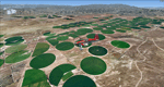
Mormon Range, Enterprise, Beryl (UT82), Utah, Photo-Scenery (FS9 & FSX)
This scenery covers the area of just north of St. George (KSGU) north along the Mormon Range and Enterprise to Beryl (UT82). It completes the southwestern corner of Utah and paves our way into Nevada. High resolution versions of this scenery for FS9 and FSX (much sharper, but larger and multiple downloads)are available at www.blueskyscenery.com/CNY_South2West6.html . The screenies are taken from the high-res versions, so expect this version to be slightly more blurry.
Thanks to Joop Mak for providing a custom AFCADs that correct airport layouts so that they align with the photo-textures! They are available at www.blueskyscenery.com/AFCADs.html . YourDonation@Work: Dedicated to Jean Pierre, Konrad and Juan.
| Filename: | Mormon_Range_Enterprise_Beryl_UT82_Utah_PhotoScene.zip |
| License: | Freeware, limited distribution |
| Added: | 27th March 2010, 11:38:48 |
| Downloads: | 1,371 |
| Author: | Gottfried Razek, blueskyscenery.com |
| Size: | 97.45 MB |


© 2001-2026 AVSIM Online
All Rights Reserved
Privacy Policy |