
Where Flight Simulation Enthusiasts Gather from Around the World!
AVSIM Library - Search Results

| Category: Flight Simulator 2004 - Scenery | |
| Torrey, Box-Death Hollow Wilderness, Aquarius Plateau, Utah, Photo-Scenery (FS9 & FSX) |

|
Images related to this file:
File Description:
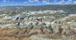
The southern part of this region covers the Box-Death Hollow Wilderness, with its vertical gray-orange walls of Navajo sandstone. Then comes the Aquarius Plateau which is the highest timbered plateau in North America with Boulder Mountain. In the north you'll find the little town of Torrey, which is just eight miles west of Capitol Reef National Park. Extends my Grand Staircase Escalante scenery to the north.
High resolution versions of this scenery for FS9 and FSX (much sharper, but larger and multiple downloads) are available at www.blueskyscenery.com/CNY_SouthWest3.html . The screenies are taken from the high-res versions, so expect this version to be slightly more blurry.
Thanks to Joop Mak for providing a custom AFCADs that correct airport layouts so that they align with the photo-textures! They are available here: www.blueskyscenery.com/AFCADs.html . YourDonation@Work: Dedicated to Ralf-Peter, Jon and Laurent.
| Filename: | Torrey_BoxDeath_Hollow_Wilderness_Aquarius_Plateau.zip |
| License: | Freeware, limited distribution |
| Added: | 3rd April 2010, 00:52:09 |
| Downloads: | 1,202 |
| Author: | Gottfried Razek - blueskyscenery.com |
| Size: | 93.79 MB |
| Category: Flight Simulator 2004 - Scenery | |
| Anchorage Ted Stevens Int'l Airport - PANC v1.1 |
|
Images related to this file:
File Description:
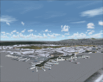
Scenery enhancement for Anchorage Int'l Airport (PANC). Adds Terminal C, made to look as close to real as possible given the tools we had. Replaces all the default jetways with more realistic ones. Replaces stock buildings with hangars and buildings that more closely resemble the real thing. Redoes the AFCAD for proper parking and ramp shape. This scenery makes extensive use of the EZ Scenery libraries and Rwy12 libraries listed in the "Required Library Files Lists" folder. (This was originally just a re-upload of the original file, but we realized (3 years later) that we forgot to include Jim Vile's PANC_ILS files tht he'd permitted us to use. That's been fixed. So most of this scenery is the original, but includes Jim's work as well. ALSO, as we'll be viewing the recent terminal upgrades in late May of 2010, there may be an update coming out soon after.)
| Filename: | Anchorage_Ted_Stevens_Intl_Airport__PANC_v11.zip |
| License: | Freeware, limited distribution |
| Added: | 8th April 2010, 00:05:03 |
| Downloads: | 2,982 |
| Author: | Rob Diebold, Craig Dightman |
| Size: | 2.54 MB |
| Category: Flight Simulator 2004 - Scenery | |
| 1962 and 1965 Tokyo Haneda Airport Scenery |
|
File Description:
This scenery represents the international airport of Tokyo in the 1960's, Haneda. This package also removes the modern airport of Narita. There are two versions of the airport in this package, 1962 and 1965. Today, Tokyo International Airport (known to locals as Haneda) is consistently among the five busiest airports in the world. In the early 1960s, it was the only international airport serving the economic recovery of the Japanese capital. The entire airport was upgraded extensively between 1961 and 1964 in preparation for the Tokyo Olympics in October of '64. By 1965, a longer runway 15/33, expanded terminal, and improved ground transportation links were all in use at Haneda (these changes are reflected in the '62 and '65 versions). Terminal and ground details by Aaron Seymour, JAMCO/JAL hangars and AFCAD files by Tom Gibson. Thanks to Wolfgang Gersch for the parking area.
| Filename: | 1962_and_1965_Tokyo_Haneda_Airport_Scenery.zip |
| License: | Freeware, limited distribution |
| Added: | 5th October 2008, 20:43:08 |
| Downloads: | 3,845 |
| Author: | Aaron Seymour and Tom Gibson |
| Size: | 1.04 MB |
| Category: Flight Simulator 2004 - Scenery | |
| Kerkira Airport Enhancement |
|
File Description:
This is old scenery which has been updated for FS2004 and enhances the visual environment of Ionian sea island airport of Kerkira, also known as Corfu. Its part of my “Greek Airfields” package that currently is not fully compatible with FS2004 since MS decided to move the airports in Greece and elsewhere to adjacent positions and ASD, which I use for placing these objects, is not compatible with FS2004. Here you will find airport & terrain enhancements for Hellenic airport of Kerkira LGKR that make it look closer to the real one; hotels, runway turning bay, perimeter fences, windsocks, radio antennae, new approach radar antenna to the southwest and most importantly, an exclusion of autogen scenery that is wrongfully generated on each side of the runway. A big difference is attributed to Babis Peribolas’s Kerkira mesh terrain that is included in this scenery. Scenery includes the necessary ASD 2.1 textures.
| Filename: | Kerkira_Airport_Enhancement.zip |
| License: | Freeware, limited distribution |
| Added: | 4th September 2003, 02:23:06 |
| Downloads: | 12,174 |
| Author: | Kyprianos Biris |
| Size: | 1.94 MB |
| Category: Flight Simulator 2004 - Scenery | |
| Kasba Lake CJL8 Northwest Territories Canada |
|
Images related to this file:
File Description:
This is a sixth airfield with links to Lake Athabasca, which is in Alberta and Saskatchewan. Kasba Lake is some 135 miles northeast of Stony Rapids and is in the Northwest Territories. The airfield is owned and run by and for Kasba Lake Lodge and it is one of several fishing vacation spots that are serviced by flights from Stony Rapids. It is these flights to the north that explain the number of regular scheduled flights into Stony Rapids from the south. The Kasba Lake Lodge has docks for boats and also for clients that want to arrive in their own floatplanes. The ai is for both Kasba Lake and Obre Lake and replaces the porpoising plane that I had used for Obre Lake. Norilor flies the weekend package-deal-long-distance delivery flights for Kasba Lake direct from Winnipeg, and now also for Obre Lake.
| Filename: | Kasba_Lake_CJL8_Northwest_Territories_Canada.zip |
| License: | Freeware, limited distribution |
| Added: | 9th August 2018, 14:21:17 |
| Downloads: | 149 |
| Author: | Roger Wensley |
| Size: | 2.48 MB |
| Category: Flight Simulator 2004 - Scenery | |
| Revised East Vancouver Islands - compatible with vicenh05 |
|
File Description:
These files are a revision of the default Vancouver Island shorelines and landclass textures from Chemainus to Campbell River, British Columbia. Included are the islands from the Southern Gulf Islands to Texada Island and inland to Cowichan Lake. Most of the smaller lakes within 20 km of the shoreline have been redrawn as well. In this version shorelines have been revised to match Jon Patch & Holger Sandman's vicenh05.zip. As well major corrections for the shorelines in LOD5 area 117-114, Comox, have been made so that the shorelines now conform to the 38.2m mesh and to Vern Opperman's CFB - Comox version 042. Shoreline types are changed to look more like the Pacific Northwest courtesy of Holger Sandman's who made his shoreline textures for vicenh05 available. Also in this version no roads are included since complete British Columbia roads in bcroadsys.zip are now available.
| Filename: | Revised_East_Vancouver_Islands__compatible_with_vi.zip |
| License: | Freeware, limited distribution |
| Added: | 8th October 2005, 20:17:46 |
| Downloads: | 3,927 |
| Author: | Harvey Janszen |
| Size: | 346.85 KB |
| Category: Flight Simulator 2004 - Scenery | |
| Dawson Creek CYDQ in British Columbia, Canada |
|
Images related to this file:
File Description:
Dawson Creek is at 2,148 feet asl just east of the Rocky Mountains, less than 10 miles west of the BC/Alberta border. The Peace River, 25 miles north of Dawson Creek, links the two sides of the Rockies, winding through peaks that reach up almost to 8,000 feet. The population grew when the Northern Alberta Railway was extended to Dawsons Creek in 1932, and grew even more more when the Alaska Highway was built in 1942 and Dawsons Creek was where it started from. The airport is just to the east of the town. The runway is 5,000 feet of wide asphalt (150 feet) aligned 06/24, lit, and with PAPI and approach lights. There is a water runway to the north of the main runway with the same alignment, separately designated as Dawson Creek CBD3. The two operate as one; traffic for both use the mandatory frequency of 122.2 and talk to one controller in one control tower. However, in FS9 the ATC for two separately designated airfields operates as if they are nowhere near each other and near misses are the result. I have put them both in un-manned tower mode so you will announce your position and intentions and select your own parking spots etc. There is in reality a lack of apron markings but I have marked the positions of both gates. The apron is not large so there is only one other apron parking spot (see the traffic cone) and most parking is either next to one of the hangars or on the grass. The aprons vary from asphalt, to concrete, onwards to gravel, and then further onwards to some gravel amid the bare dirt; I have replicated this variation as far as FS9 permits. The buildings are bespoke from photos. The AI includes Central Mountain Air with two daily scheduled flights and Northern Cariboo as one of the airlines that occasionally runs charter flights in CYDQ. There are also private GA flights, and float plane flights into and out of CBD3.
| Filename: | Dawson_Creek_CYDQ_in_British_Columbia_Canada.zip |
| License: | Freeware, limited distribution |
| Added: | 22nd November 2013, 23:31:40 |
| Downloads: | 652 |
| Author: | Roger Wensley |
| Size: | 16.65 MB |
| Category: Flight Simulator 2004 - Scenery | |
| Twin Lakes Airstrips in British Columbia Canada |
|
Images related to this file:
File Description:
There are three grass airstrips within sight of each other from the air at Twin Lakes in BC, which is between the close junction of Elkin Lake and Vedan Lake. The two lakes are similarly shaped and sized and in the same narrow valley between high ground that runs north-south; hence the name. Elkin is to the north, and Vedan is to the south. Twin Lakes CAG4 is on the strip of land between the two lakes and it is unclear to me who it belongs to etc. It is not in the Nav Canada copy that I have with me which is from 2010, and the online version does not cover grass strips. It is probably owned by whoever lives in the house next to the red hangar. The runway is 3,600 feet of grass aligned 14-32 at 3,945 feet ASL. Chaunigan Lake Lodge CF83 is over to the northwest from Twin Lakes by around 2 miles or so and as the name suggests it services the Lodge of that name, which is on the northeast corner of Chaunigan Lake. The runway is 2,600 feet of grass aligned 02-20 at 4,900 feet ASL. You might want to read about altitude power reductions for the take off. Elkin Creek Guest Ranch CBL9 is at the southern end of Vedan Lake and serves the ranch. This appears to be another high-budget operation and the runway is 3,670 feet of grass aligned 36-18 at 3,999 feet ASL. I have posted this as three separate airstrips, but I suggest that you add these to your "BC airfields" folder as previously suggested. Up to you. If you find a defect, email me. Ignore the post of Chilanko Lodge posted today. I requested Avsim to delete it but it seems they didn't read the email. It was originally posted as a correction for the original post of the three posted here.
| Filename: | Twin_Lakes_Airstrips_in_British_Columbia_Canada.zip |
| License: | Freeware, limited distribution |
| Added: | 21st November 2020, 23:29:09 |
| Downloads: | 125 |
| Author: | Roger Wensley |
| Size: | 25.39 MB |
| Category: Flight Simulator 2004 - Scenery | |
| RAF Woodvale, EGOW |
|
File Description:
Back in January 2001 Danny Rowland of the AI Scenery Club released a freeware scenery of RAF Woodvale for use in FS2000. The files included in this zip will enable users to install this fine piece of scenery within FS2004 with all facilties working for AI traffic to inhabit RAF Woodvale.
This zip includes; AF2 file for Woodvale, fully tested flightplans, amended FS2004 default bgl file to prevent AI Traffic floating above ground level, especially for for users of Eddie Denney's freeware UK SRTM Mesh Scenery, I have not tested the scenery with the FS2004 default terrain mesh which I don't use.
Also included are screenshots of RAF UAS Bulldog aircraft "thrashing" the circuit at Woodvale, and full instructions of how to set this up for yourself, with locations of freeware aircraft and zip file names for you to download to achieve this.
Thanks once more to Danny Rowland for his Woodvale scenery, which incidentally does not show it's age when used in FS2004.
| Filename: | RAF_Woodvale_EGOW.zip |
| License: | Freeware, limited distribution |
| Added: | 11th March 2004, 20:45:52 |
| Downloads: | 1,425 |
| Author: | Bill Hughes |
| Size: | 202.42 KB |
| Category: Flight Simulator 2004 - Scenery | |
| Christchurch, UK circa 1944 |
|
File Description:
Christchurch began its existance in 1926 when a field known as Burrys field near Mudeford, Christchurch UK was used for pleasure flights.In 1935 airfield became known as Bournemouth Airport. Christchurch Airfield was therefore the original Bournemouth Airport. In the early March of 1944, the USAAF arrived as the 509th, 510th and 511th Fighter Squadrons of the 405th Fighter Group. The squadrons flew P47 aircraft on raids over occupied France. All the 405th units left for airfields in occupied France shortly after D-Day. Production of Mosquitos, Horsa Gliders and the Oxford was undertaken here during war time and post war the Airspeed Ambassador and the DH Sea Vixen. Hurn is now "Bournemouth Airport". Christchurch was closed in 1964 and after some years the site developed for housing. Regretably there is no Memorial to the airmen who flew from here or any reminder of their sacrifice. Many people I have met who live on what was the airfield have no idea that it ever existed!
| Filename: | Christchurch_UK_circa_1944.zip |
| License: | Freeware |
| Added: | 19th July 2008, 13:09:24 |
| Downloads: | 728 |
| Author: | Kit Yardley |
| Size: | 5.14 MB |
© 2001-2026 AVSIM Online
All Rights Reserved
Privacy Policy |