
Where Flight Simulation Enthusiasts Gather from Around the World!
AVSIM Library - Search Results

| Category: Flight Simulator 2004 - Scenery | |
| California Central Coast Revision #3 |

|
Images related to this file:
File Description:
This is revision #3 to CCCOASTX.ZIP for FS2004 uploaded and dated 4/18/06 and only applies
to that version of my California Central Coast Scenery. Rev 3 includes several SBP modifications to reflect current and pending real world construction projects. Also revised "T" hangars at several airports, added distance signs on IFR runways at SBP, SMX, SBA and some minor PRB building graphics revisions. CCCOASTX.ZIP, CCCXREV1.ZIP, CCCXREV2.ZIP and CCCXFIX.ZIP required. Al Wheeler 11/3/06.
Note: This is a re-upload to replace the original ZIP that was corrupted by the Avsim hack.
| Filename: | California_Central_Coast_Revision_3.zip |
| License: | Freeware |
| Added: | 31st May 2010, 14:46:17 |
| Downloads: | 1,989 |
| Author: | Al Wheeler |
| Size: | 1.44 MB |
| Category: Flight Simulator 2004 - Scenery | |
| Project Mexico Real LOD10 File 8 of 11 |
|
Images related to this file:
File Description:
File 8th of 11 of a Terrain Mesh that covers the entirety of Mexican Territory and related bordering U.S., Guatemala and Belice areas, part of the "Proyecto M�©xico Real" project, compiled at LOD10 (1.24 arcseconds in latitude and 1.65 arcseconds in longitude) resolution from INEGI data. Intended to enhance the virtual flying experience complementing the LOD8 and LOD9 versions compiled from the same data. Compatible backwards with Flight Simulator 2000, Flight Simulator 2002 and Combat Flight Simulator 2. Refer to the file contents about the cover area to this compressed file. (Re-upload due to AVSIM hack)
| Filename: | Project_Mexico_Real_LOD10_File_8_of_11.zip |
| License: | Check within download |
| Added: | 29th August 2010, 04:15:59 |
| Downloads: | 1,172 |
| Author: | Juan Jose Galvan Bautista |
| Size: | 73.7 MB |
| Category: Flight Simulator 2004 - Scenery | |
| Project Mexico Real LOD10 File 5 of 11 |
|
Images related to this file:
File Description:
Re-upload. File 5th of 11 of a Terrain Mesh that covers the entire Mexican Territory and related areas bordering the U.S., Guatemala and Belize areas. Part of the "Proyecto M�©xico Real" project, compiled at LOD10 (1.24 arcseconds in latitude and 1.65 arcseconds in longitude) resolution from INEGI data. Intended to enhance the virtual flying experience complementing the LOD8 and LOD9 versions compiled from the same data. Compatible backwards with Flight Simulator 2000, Flight Simulator 2002 and Combat Flight Simulator 2. Refer to the file contents about the cover area to this compressed file.
| Filename: | Project_Mexico_Real_LOD10_File_5_of_11.zip |
| License: | Check within download |
| Added: | 7th August 2010, 22:08:10 |
| Downloads: | 3,015 |
| Author: | Juan Jose Galvan Bautista |
| Size: | 73.08 MB |
| Category: Flight Simulator 2004 - Scenery | |
| Project Mexico Real LOD10 File 7 of 11 |
|
Images related to this file:
File Description:
File 7th of 11 of a Terrain Mesh that covers the entirety of Mexican Territory and related bordering U.S., Guatemala and Belice areas, part of the "Proyecto Mexico Real" project, compiled at LOD10 (1.24 arcseconds in latitude and 1.65 arcseconds in longitude) resolution from INEGI data. Intended to enhance the virtual flying experience complementing the LOD8 and LOD9 versions compiled from the same data. Compatible backwards with Flight Simulator 2000, Flight Simulator 2002 and Combat Flight Simulator 2. Refer to the file contents about the cover area to this compressed file. (Re-upload due to AVSIM hack)
| Filename: | Project_Mexico_Real_LOD10_File_7_of_11.zip |
| License: | Check within download |
| Added: | 23rd August 2010, 00:40:35 |
| Downloads: | 2,864 |
| Author: | Juan Jose Galvan Bautista |
| Size: | 74.25 MB |
| Category: Flight Simulator 2004 - Scenery | |
| Project Mexico Real LOD10 File 2 of 11 |
|
Images related to this file:
File Description:
File 2nd of 11 of a Terrain Mesh that covers the entirety of Mexican Territory and related bordering U.S., Guatemala and Belice areas, part of the "Proyecto M�©xico Real" project, compiled at LOD10 (1.24 arcseconds in latitude and 1.65 arcseconds in longitude) resolution from INEGI data. Intended to enhance the virtual flying experience complementing the LOD8 and LOD9 versions compiled from the same data. Compatible backwards with Flight Simulator 2000, Flight Simulator 2002 and Combat Flight Simulator 2. Refer to the file contents about the cover area to this compressed file. (Re-upload due to AVSIM hack)
| Filename: | Project_Mexico_Real_LOD10_File_2_of_11.zip |
| License: | Check within download |
| Added: | 7th June 2010, 08:52:32 |
| Downloads: | 3,315 |
| Author: | Juan Jose Galvan Bautista |
| Size: | 76.38 MB |
| Category: Flight Simulator 2004 - Scenery | |
| Project Mexico Real LOD10 File 9 of 11 |
|
Images related to this file:
File Description:
File 9th of 11 of a Terrain Mesh that covers the entirety of Mexican Territory and related bordering U.S., Guatemala and Belice areas, part of the "Proyecto Mexico Real" project, compiled at LOD10 (1.24 arcseconds in latitude and 1.65 arcseconds in longitude) resolution from INEGI data. Intended to enhance the virtual flying experience complementing the LOD8 and LOD9 versions compiled from the same data. Compatible backwards with Flight Simulator 2000, Flight Simulator 2002 and Combat Flight Simulator 2. Refer to the file contents about the cover area to this compressed file. (Re-upload due to AVSIM hack)
| Filename: | Project_Mexico_Real_LOD10_File_9_of_11.zip |
| License: | Check within download |
| Added: | 29th August 2010, 23:24:57 |
| Downloads: | 1,195 |
| Author: | Juan Jose Galvan Bautista |
| Size: | 76.35 MB |
| Category: Flight Simulator 2004 - Scenery | |
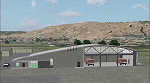
| Oostwold Airport (EHOW) Version 1.0 |
|
Images related to this file:
File Description:
This packet contains a completely new (build from the ground up) scenery of the Oostwold airport (unofficial ICAO-code EHOW) in the North-east part of Groningen, The Netherlands. The scenery is made up to date with the situation at the airport up to end of 2010. The new mess building is present as well the improved taxiway (new asphalt). Besides the airport this scenery adds also some farms, factory and other buildings within the circuit area of the airport. Charts of the airport are included.
Scenery is compatible with FS2004 (FS9) default scenery OR NL2000 scenery version 3.0SE.
| Filename: | Oostwold_Airport_EHOW_Version_10.zip |
| License: | Freeware, limited distribution |
| Added: | 8th January 2011, 19:03:19 |
| Downloads: | 878 |
| Author: | Marcel Ritzema |
| Size: | 4.06 MB |
| Category: Flight Simulator 2004 - Scenery | |
| Queensland2 Soaring Scenery |
|
File Description:
FS2004 Queensland2 Soaring Scenery
These files adds some thermals to default Microsoft Scenery ,over below Regions:
1.Nebo Airstrip
Coordinates:
S 21* 42´ 14´´ - E 148* 41´138´´ - Elevation - 655ft
2.Ilbilbie City -
Coordinates:
S 21* 42´19´´ - E 149* 21´27´´ - Elevation - 120ft
3.Eungella Hang Glider Site
Coordinates:
S 21* 7´52´´ - W 148* 29´36´´ - Elevation - 2,200ft
4.Flights for 3 above sites are found at option: Tool Bar(Screen Top of FS9) - choose Flights and Select a Flight(Soaring over Nebo,Ilbilbie or Eungella).
It is freeware.
Goods flights and better landings
By Francisco Vargas.
E-mail:[email protected]
| Filename: | Queensland2_Soaring_Scenery.zip |
| License: | Freeware |
| Added: | 13th November 2005, 23:14:33 |
| Downloads: | 243 |
| Author: | Francisco Augusto Vargas Carneiro |
| Size: | 204.84 KB |
| Category: Flight Simulator 2004 - Scenery | |
| Colorado 2, Soaring Scenery_Upload |
|
File Description:
FS2002/2004 Colorado 2, Soaring Scenery.
This file came about because I wanted some lifts to keep gliders over Colorado Region, to soaring flights from Larkspur City to Colorado Springs City,Colorado,USA and so on.
It adds some ridge lifts to default Microsoft scenery
And it will be useful to everybody who wants begin primary and advanced glider flight instruction.
The lift begins 900 feet above ground level and the lift field is a North-South line which begins near Larkspur City North of Colorado Springs City
Installation:
Unzip MIcrosoft Simulator9.zip file inside Microsoft Games folder
Good flights end better Landings.
| Filename: | Colorado_2_Soaring_Scenery_Upload.zip |
| License: | Freeware |
| Added: | 9th March 2006, 03:55:21 |
| Downloads: | 414 |
| Author: | Francisco Augusto Vargas Carneiro |
| Size: | 93.82 KB |
| Category: Flight Simulator 2004 - Scenery | |
| KMSN Madison Reg-Truax ANG Retro |
|
File Description:
This is a retro scenery covering the late 50s early 60s with Civil, USAF and ANG aircraft stationed there during this period which is my interest. DeltaDart has provided period Squadron Textures for most of the aircraft included in this scenery including the F89 Scorpion, F-86L SabreDogs, and the F-102 Delta Dagger. Individual traffic files included for 1955, 1957. 1959 and 1962, all with various aircraft from each covered year. This scenery is meant to be used in the Calclassic environment by Tom Gibson and the Calclassic community though it will work on its own. By Al Von Pingel.
| Filename: | KMSN_Madison_RegTruax_ANG_Retro.zip |
| License: | Freeware |
| Added: | 8th February 2023, 05:31:17 |
| Downloads: | 96 |
| Author: | Al Von Pingel |
| Size: | 29.47 MB |
© 2001-2026 AVSIM Online
All Rights Reserved
Privacy Policy |