
Where Flight Simulation Enthusiasts Gather from Around the World!
AVSIM Library - Search Results

| Category: Flight Simulator 2004 - Scenery | |
| Budd Lake Airfield |

|
File Description:
FS2004 Scenery - This is another retro scenery I found interesting enough to design for your flying enjoyment.Budd Lake Airfield,Budd Lake, NJ was apparently opened at some point between 1945-49, as it was not depicted at all on the 1945 NY Sectional Chart nor on the 1947 USGS topo map.
The earliest depiction of the airfield which has been located was on the 1949 NY Sectional Chart. The airport began business shortly after WW2. The property owner's son wanted a place close to home where he could learn to fly & keep his airplane. Created with Instant Scenery by John B. Loney, Jr.
| Filename: | Budd_Lake_Airfield.zip |
| License: | Freeware, limited distribution |
| Added: | 2nd January 2009, 01:54:04 |
| Downloads: | 235 |
| Author: | John B. Loney, Jr. |
| Size: | 2.82 MB |
| Category: Flight Simulator 2004 - Scenery | |
| UK FarmStrips nonVFR |
|
File Description:
This mod removes the autogen scenery from the UK FARMSTRIPS runways if not using VFR PHOTO SCENERY.
These files serve only to compliment Gerry Winskill's work, not alter or modify it in any way.
It misses the point of Gerry's work really as it flattens the runways a bit, but there's nothing we can do about that... it just allows you to fly with regular autogen on maximum. Because of this though, elevations may differ slightly to those using VFR scenery and the default UK FARMSTRIPS...in online multiplayer for example.Requires UK FARMSTRIPS vol 1 to 3 by Gerry Winskill
| Filename: | UK_FarmStrips_nonVFR.zip |
| License: | Freeware |
| Added: | 8th April 2009, 12:36:01 |
| Downloads: | 251 |
| Author: | Paul Leaver |
| Size: | 836.68 KB |
| Category: Flight Simulator 2004 - Scenery | |
| Emergency Services Incident # 2010-001 |
|
Images related to this file:
File Description:
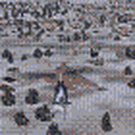
This is a series of missions called Emergency Services. All mission are flown using the Bell 206B JetRanger Helicopter. You may be flying for Fire Rescue, Medical Rescue or for the Police. Each mission is given an incident number. You will be required to navigate to these incident using the navigation charts or street maps. Print the maps prior to your flight. You will be given the coodinates during your briefing. You will need to plot your own course to each destination.
In this mission you will be flying for Fire Rescue. Your incident number is 2010-001
| Filename: | Emergency_Services_Incident__2010001.zip |
| License: | Freeware |
| Added: | 20th January 2010, 01:37:59 |
| Downloads: | 339 |
| Author: | David J Crandall |
| Size: | 4.77 MB |
| Category: Flight Simulator 2004 - Scenery | |
| Old Rhinebeck Aerodrome |
|
File Description:
Old Rhinebeck, the living museum of antique aviation, located at NY94 in Rhinebeck NY. Included are all the buildings and hangars at the field. Photoreal ground textures for the Rock City area surrounding ORA. All lakes streams, and rivers were hand edited for accuracy. Hand placed autogen and trees to match the ground textures. Special effects that make crowds of people appear during show times, and a few easter eggs as well. Mesh compliled from clean 1 arc sec SRTM data. Afcad is AI ready for your flightplans. All Gmax 3d models, and optimized textures for smooth performance.
happy flyin.
| Filename: | Old_Rhinebeck_Aerodrome.zip |
| License: | Freeware, limited distribution |
| Added: | 4th December 2005, 03:32:41 |
| Downloads: | 4,616 |
| Author: | Joe Binka |
| Size: | 38.57 MB |
| Category: Flight Simulator 2004 - Scenery | |
| Military Cargo Objects Library |
|
Images related to this file:
File Description:
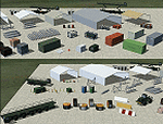
This object library was created to provide various cargo-type items as well as related vehicles and objects that would be found on loading ramps and aprons. I originally created this library for the exclusive use of the MAIW group and it has been upgraded several times. As the library has had wide distribution (and is now becoming somewhat dated) I am now offering it for general public use as a stand alone library. This is an expanded version of this library and there will be no further versions released. Library should be FSX compatible but has not been fully tested.
| Filename: | Military_Cargo_Objects_Library.zip |
| License: | Freeware, limited distribution |
| Added: | 1st May 2014, 03:43:27 |
| Downloads: | 1,820 |
| Author: | John Stinstrom |
| Size: | 875.66 KB |
| Category: Flight Simulator 2004 - Scenery | |
| California Central Coast Revision #3 |
|
Images related to this file:
File Description:
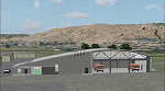
This is revision #3 to CCCOASTX.ZIP for FS2004 uploaded and dated 4/18/06 and only applies
to that version of my California Central Coast Scenery. Rev 3 includes several SBP modifications to reflect current and pending real world construction projects. Also revised "T" hangars at several airports, added distance signs on IFR runways at SBP, SMX, SBA and some minor PRB building graphics revisions. CCCOASTX.ZIP, CCCXREV1.ZIP, CCCXREV2.ZIP and CCCXFIX.ZIP required. Al Wheeler 11/3/06.
Note: This is a re-upload to replace the original ZIP that was corrupted by the Avsim hack.
| Filename: | California_Central_Coast_Revision_3.zip |
| License: | Freeware |
| Added: | 31st May 2010, 14:46:17 |
| Downloads: | 1,989 |
| Author: | Al Wheeler |
| Size: | 1.44 MB |
| Category: Flight Simulator 2004 - Scenery | |
| Project Mexico Real LOD10 File 8 of 11 |
|
Images related to this file:
File Description:
File 8th of 11 of a Terrain Mesh that covers the entirety of Mexican Territory and related bordering U.S., Guatemala and Belice areas, part of the "Proyecto M�©xico Real" project, compiled at LOD10 (1.24 arcseconds in latitude and 1.65 arcseconds in longitude) resolution from INEGI data. Intended to enhance the virtual flying experience complementing the LOD8 and LOD9 versions compiled from the same data. Compatible backwards with Flight Simulator 2000, Flight Simulator 2002 and Combat Flight Simulator 2. Refer to the file contents about the cover area to this compressed file. (Re-upload due to AVSIM hack)
| Filename: | Project_Mexico_Real_LOD10_File_8_of_11.zip |
| License: | Check within download |
| Added: | 29th August 2010, 04:15:59 |
| Downloads: | 1,172 |
| Author: | Juan Jose Galvan Bautista |
| Size: | 73.7 MB |
| Category: Flight Simulator 2004 - Scenery | |
| Project Mexico Real LOD10 File 5 of 11 |
|
Images related to this file:
File Description:
Re-upload. File 5th of 11 of a Terrain Mesh that covers the entire Mexican Territory and related areas bordering the U.S., Guatemala and Belize areas. Part of the "Proyecto M�©xico Real" project, compiled at LOD10 (1.24 arcseconds in latitude and 1.65 arcseconds in longitude) resolution from INEGI data. Intended to enhance the virtual flying experience complementing the LOD8 and LOD9 versions compiled from the same data. Compatible backwards with Flight Simulator 2000, Flight Simulator 2002 and Combat Flight Simulator 2. Refer to the file contents about the cover area to this compressed file.
| Filename: | Project_Mexico_Real_LOD10_File_5_of_11.zip |
| License: | Check within download |
| Added: | 7th August 2010, 22:08:10 |
| Downloads: | 3,015 |
| Author: | Juan Jose Galvan Bautista |
| Size: | 73.08 MB |
| Category: Flight Simulator 2004 - Scenery | |
| Project Mexico Real LOD10 File 7 of 11 |
|
Images related to this file:
File Description:
File 7th of 11 of a Terrain Mesh that covers the entirety of Mexican Territory and related bordering U.S., Guatemala and Belice areas, part of the "Proyecto Mexico Real" project, compiled at LOD10 (1.24 arcseconds in latitude and 1.65 arcseconds in longitude) resolution from INEGI data. Intended to enhance the virtual flying experience complementing the LOD8 and LOD9 versions compiled from the same data. Compatible backwards with Flight Simulator 2000, Flight Simulator 2002 and Combat Flight Simulator 2. Refer to the file contents about the cover area to this compressed file. (Re-upload due to AVSIM hack)
| Filename: | Project_Mexico_Real_LOD10_File_7_of_11.zip |
| License: | Check within download |
| Added: | 23rd August 2010, 00:40:35 |
| Downloads: | 2,864 |
| Author: | Juan Jose Galvan Bautista |
| Size: | 74.25 MB |
| Category: Flight Simulator 2004 - Scenery | |
| Project Mexico Real LOD10 File 9 of 11 |
|
Images related to this file:
File Description:
File 9th of 11 of a Terrain Mesh that covers the entirety of Mexican Territory and related bordering U.S., Guatemala and Belice areas, part of the "Proyecto Mexico Real" project, compiled at LOD10 (1.24 arcseconds in latitude and 1.65 arcseconds in longitude) resolution from INEGI data. Intended to enhance the virtual flying experience complementing the LOD8 and LOD9 versions compiled from the same data. Compatible backwards with Flight Simulator 2000, Flight Simulator 2002 and Combat Flight Simulator 2. Refer to the file contents about the cover area to this compressed file. (Re-upload due to AVSIM hack)
| Filename: | Project_Mexico_Real_LOD10_File_9_of_11.zip |
| License: | Check within download |
| Added: | 29th August 2010, 23:24:57 |
| Downloads: | 1,195 |
| Author: | Juan Jose Galvan Bautista |
| Size: | 76.35 MB |
© 2001-2026 AVSIM Online
All Rights Reserved
Privacy Policy |