
Where Flight Simulation Enthusiasts Gather from Around the World!
AVSIM Library - Search Results

| Category: Flight Simulator 2004 - Scenery | |
| HCMM - Mogadishu International Airport, Mogadishu/Petrella, Somalia |

|
Images related to this file:
File Description:
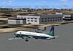
Googly scenery for HCMM Mogadishu/Petrella, the capital airport of Somalia.
Astonishingly, in Flight Simulator 2004 this international airport is depicted as little
more than a runway! Whilst in the real world the airport can hardly be
described as busy, it is served by the country's sole airline - Jubba
Airways, with their wonderful Ilyushin IL-18, and many African and Eastern
European operators call by with cargo flights. In fact, the vast proportion of
the aircraft seen here are Russian-built.
These scenery files add aprons, taxiways, buildings and other airport features to Flight Simulator's limited representation and allow "AI" traffic to land, taxi, park and take off in a realistic manner. But do watch out for cars on the runway and taxiways as they
appear to be regularly used as a by-pass to the perils of driving through the city!
The scenery does not purport to be ultra-accurate. Based on high-detail satellite
imagery from Google Earth, the layout is proportionally correct but the added
airport features, such as buildings, are built from default Microsoft objects
and add-on libraries so will not look exactly like the real thing.
You are not obliged to download and install any additional scenery libraries,
but to enjoy this scenery in its entirety, you may wish to. It will work fine,
with or without. [File re-uploaded at request of AVSIM]
| Filename: | HCMM__Mogadishu_International_Airport_MogadishuPet.zip |
| License: | Freeware |
| Added: | 28th May 2010, 20:46:31 |
| Downloads: | 2,790 |
| Author: | John Hinson |
| Size: | 61.51 KB |
| Category: Flight Simulator 2004 - Scenery | |
| Maurice Bishop TGPY on Grenada in the Caribbean |
|
Images related to this file:
File Description:
Grenada island is 17 miles south of the southernmost island of the Grenadines, Carriacou; there are some smaller islands between the two. Grenada is 18 miles long and around 8 miles wide, has an estimated population of 110,000, and produces a very large part of the world's annual nutmeg harvest. The capital, St Georges, is by far the largest town and is at the southern end of the island, with the airport close by.
The airport is now called Maurice Bishop, but for some years was called Point Salines. The runway is just over 9,000 feet long and oriented 10/28. Point Salines replaced Pearl Airport, which is on the east coast 12 miles northeast of St Georges and was difficult to expand as the runway had mountains at one end and the sea at the other. Pearl is now closed; it is included here but only as a visual landmark with "closed" markings. There are regular international flights from North America and Europe, some of which are seasonal only (Air Canada for instance) and local connecting flights by LIAT and SVG. I retained the default control tower as it is some distance away. In real life it is also some distance away and on a hill northwest of the terminal. Which is why I did not take photos from which I would have made the real one. The hill does not feature in FS9.
| Filename: | Maurice_Bishop_TGPY_on_Grenada_in_the_Caribbean.zip |
| License: | Freeware, limited distribution |
| Added: | 11th June 2013, 23:28:17 |
| Downloads: | 825 |
| Author: | Roger Wensley |
| Size: | 7.38 MB |
| Category: Flight Simulator 2004 - Scenery | |
| St. George (KSGU) / Mesquite (67L), Utah/Nevada, Photo-Scenery (FS9 & FSX) |
|
Images related to this file:
File Description:
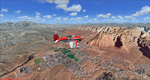
Covers the area between St. George, Utah and Mesquite, Nevada. To the north of St. George
the Pine Valley Mountains with their foothills of scenic red sandstone loom over the city.
St. George Municipal Airport (KSGU) is mostly used for general aviation but is also served by SkyWest Airlines
on behalf of Delta Connection. Because of it's location on a mesa this airport can't be expanded and so a new
airport is currently being built southeast of the city at the site of an abandoned airfield. The opening
is expected in 2011. To the south of the city make sure, you don't miss the Virgin River Gorge where the
Virgin River winds thru a long winding canyon in the transition zone between the red rocks of southern Utahs
Colorado Plateau and Nevadas Mojave Desert. Shortly afterwards you reach Mesquite which is situated just
west of the Arizona stateline. Like nearly all Nevada cities near the stateline Mesquite is home to several
Casinos. Mesquite Airport (67L) lies just north of the city.
High resolution versions of this scenery for FS9 and FSX (much sharper, but larger and multiple downloads)
are available at www.blueskyscenery.com/CNY_South3West6.html . The screenies are taken from the high-res versions,
so expect this version to be slightly more blurry. Thanks to Joop Mak for providing custom AFCADs that
correct airport layouts so that they align with the photo-textures! They are available at www.blueskyscenery.com/AFCADs.html .
YourDonation@Work: Dedicated to Werner, Ralf-Peter and Nels.
| Filename: | St_George_KSGU__Mesquite_67L_UtahNevada_PhotoScene.zip |
| License: | Freeware, limited distribution |
| Added: | 24th March 2010, 19:41:43 |
| Downloads: | 1,653 |
| Author: | Gottfried Razek - blueskyscenery.com |
| Size: | 95.58 MB |
| Category: Flight Simulator 2004 - Scenery | |
| FS2004 Scenery--Goose Bay Canadian Forces Base and US Air Base. Goose Bay Canadian Forces Base and US Air Base (CYYR), Newfoundland and Labrador, Canada, 1955-62. |
|
File Description:
Goose Bay Canadian Forces Base and US Air Base (CYYR), Newfoundland and Labrador, Canada, 1955-62. Originally built to facilitate the transport of US aircraft to Europe during the Second World War, during the Cold War Goose Bay was a base of major importance. Like nearby Gander it was a vital refuelling point for transatlantic crossings, but also along with the recently released Ernest Harmon Air Base (CYJT) an important part of the defences against the threat of Soviet bombers carrying muclear weapons attacking the USA via the North Pole. F-89 Scorpions and then F-102 Delta Daggers were based there, and this download includes F-89s especially made for this scenery by David Wooster. Flight plans are provided for 1955, 1957, 1959 and 1962, doing much to recreate this significant Cold War base as it really was; many of the aircraft which passed through Goose at that time are provided for.
This file is an update to the scenery issued in October 2021, made necessary by the discovery of new information as a result of further historical research. There have also been changes to the ADE and traffic files intended to improve the performance of both, and to the navaids too. Instructions are included for those installing from scratch and those updating our previous version, and there have been improvements to the clarity of the instructions for the downloading and installation of the ai aircraft.
There will be no further updates.
| Filename: | FS2004_SceneryGoose_Bay_Canadian_Forces_Base_and_U.zip |
| License: | Freeware |
| Added: | 25th December 2021, 19:00:49 |
| Downloads: | 282 |
| Author: | Al Von Pingel, Dan French, Bill Douglas, Ken Lawson |
| Size: | 50.25 MB |
| Category: Flight Simulator 2004 - Scenery | |
| Smith Mountain Lake, two private seaports - Virginia, USA |
|
Images related to this file:
File Description:
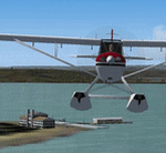
Smith Mountain Lake scenery is made to blend with autogen scenery (default). VA48 & 7VA7 seaports are left default so one may add their own AFCAD & AI traffic. Included is an EZ-landclass SmithMtnLake.bgl, its' EZL & RAW files (source files) so one may edit the area using EZ-landclass that's available as freeware download. Another distinction besides a very popular vacation lake is American Electric Powers' hydro-electric dam.
| Filename: | Smith_Mountain_Lake_two_private_seaports__Virginia.zip |
| License: | Freeware |
| Added: | 11th July 2015, 11:24:40 |
| Downloads: | 184 |
| Author: | Rick Connolly |
| Size: | 14.93 MB |
| Category: Flight Simulator 2004 - Scenery | |
| Kaluga (Grabtsevo) Airport UUBC for Light Scenery by Rulexy |
|
Images related to this file:
File Description:
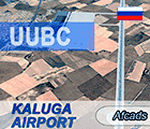
This is an updated afcad of the Kaluga (Grabtsevo) Airport (IATA: KLF, ICAO: UUBC) by Rulexy (Alexey Rubtsov) for his Light Scenery for FS2004. Added turn bays, changed runway numbers and ILS, and removed a nonexistent runway. IMPORTANT: Light Scenery and LS Addon 2 by Rulexy are required and should be installed prior to installing the afcad.
You can evaluate the airport in this video (taxi & takeoff):
https://youtu.be/wzkX9Oj5zD4
| Filename: | Kaluga_Grabtsevo_Airport_UUBC_for_Light_Scenery_by.zip |
| License: | Freeware |
| Added: | 28th November 2017, 05:22:57 |
| Downloads: | 58 |
| Author: | Gene Churumov |
| Size: | 236.24 KB |
| Category: Flight Simulator 2004 - Scenery | |
| Durango-La Plata County (KDRO) |
|
File Description:
FS2004 Scenery-Durango-La Plata County Airport (KDRO)serves Durango and La Plata County in Colorado and is owned by Durango City/La Plata County. The paved runway extends for 9201 feet. The facility is at an elevation of 6685 feet at a distance of about 10 miles from Durango. Created with EZ Scenery and Lago FSE. EZ Scenery libraries required. Lago optional. By John B. Loney, Jr.
| Filename: | DurangoLa_Plata_County_KDRO.zip |
| License: | Freeware |
| Added: | 18th December 2006, 03:45:44 |
| Downloads: | 1,622 |
| Author: | John B. Loney, Jr. |
| Size: | 590.29 KB |
| Category: Flight Simulator 2004 - Scenery | |
| Guadalupe Mountains National Park (Version 2) SRTM30_1ArcSec Terrain Mesh |
|
File Description:
This 38m terrain mesh is centered in the 'Panhandle' region of Western Texas.
Coverage area: From West 104.5° to West 105° and North 31.7° to North 32.2°.
It includes Guadalupe Mountains National Park and the surrounding mountains
of Lincoln National Forest. Version 2 replaces my former release of 'Guadalupe_Mountains_SRTM30.zip' which covered a too large area and had some scenery anomalies (craters). The new version now fixes these errors.
| Filename: | Guadalupe_Mountains_National_Park_Version_2_SRTM30.zip |
| License: | Freeware, limited distribution |
| Added: | 28th December 2003, 18:33:52 |
| Downloads: | 2,062 |
| Author: | Andreas Trawny |
| Size: | 1.27 MB |
| Category: Flight Simulator 2004 - Scenery | |
| Moffett Federal Airfield - *FIX* |
|
Images related to this file:
File Description:
Some users of my Moffett Federal Airfield scenery (KNUQ_JS3.zip) may find that the P-3 Orions do not appear. This is due to a typographical error in the aircraft.cfg file. Just drop the attached file into your "JKAI_P-3C Moffett" folder and overwrite the extisting file. Sorry for the trouble and thanks to Voorink for letting me know of the error and again to Michael Pearson for some awesome reapints.
| Filename: | Moffett_Federal_Airfield__FIX.zip |
| License: | Freeware, limited distribution |
| Added: | 23rd August 2014, 11:13:39 |
| Downloads: | 794 |
| Author: | John Stinstrom |
| Size: | 4.65 KB |
| Category: Flight Simulator 2004 - Scenery | |
| Murfreesboro Municipal - KMBT |
|
Images related to this file:
File Description:
FS2004 Scenery-Murfreesboro Municipal Airport (KMBT) serves Murfreesboro and Rutherford County and is owned by the City Of Murfreesboro. The paved runway extends for 3898 feet. The facility is at an elevation of 615 feet at a distance of about 2 miles from Murfreesboro. Created entirely with EZ Scenery. EZ Scenery library objects required. New AFCAD file and AI traffic from Traffic Tools included. By John B. Loney, Jr.
| Filename: | Murfreesboro_Municipal__KMBT.zip |
| License: | Freeware, limited distribution |
| Added: | 3rd June 2010, 00:43:34 |
| Downloads: | 817 |
| Author: | John B. Loney, Jr. |
| Size: | 1.09 MB |
© 2001-2026 AVSIM Online
All Rights Reserved
Privacy Policy |